Radtechwxman
-
Posts
2,481 -
Joined
-
Last visited
Content Type
Profiles
Blogs
Forums
American Weather
Media Demo
Store
Gallery
Everything posted by Radtechwxman
-
Definitely best Delta has looked. Even when it was high end cat 4. Eye popping on infrared and visible
-
Not saying you're wrong because that's a distinct and likely possibility. All comes down to what it does tomorrow. Just was saying it's a possibility, what I said. Very odd hurricane. It has maintained very impressive convection but has lacked to really get a strong defined core likely because of the shear.
-
I have a degree in meteorology. I understand man. I'm talking about it getting stronger the next day or so in the more favorable conditions. If you end up with a stronger storm in the short term, you will likely have it landfall stronger. Yes it has plenty working against it as it nears landfall but a well formed core of a strong hurricane just won't instantly degrade. Yes there will be weakening but with a larger circulation developing as were already seeing. That won't break down as fast as Delta did prior to landfall in Yucatan when the circulation was much smaller. It all depends on what happens while the environment is ripe for intensification
-
NHC hitting the weakening pretty hard prior to landfall. Based on it's organization tonight, I think it could overachieve current intensity forecasts
-
Oof. New advisory has Delta down to 85mph. Man model guidance has been all over for this. NHC forecasting a high end cat 2 to low end cat 3 landfall now
-
Seems like when shear is forecasted it doesn't pan out and when it isn't forecasted it appears. Delta looks very rough now. Cloud tops have remained very cold but inner core is just so sloppy. Can't recall a high end cat 4 ever with no eye visible
-
This is the ugliest 145mph hurricane I ever laid my eyes on via satellite. Lol. I'm shocked the winds went up. Only in 2020. Despite it being disorganized in the inner core, it still has took advantage of the great environment conditions.
-
Yea if someone showed me the current IR satellite loop and ask me to guess intensity I definitely wouldn't be saying cat 4. Curious if the pressure has come up more and if the winds are lower. Cloud tops still very cold but organization is poor.
-
That's a valid point. Not often you see a pressure rise correspond with a decent uptick in winds
-
140mph now. So obviously still undergoing rapid intensification. Pressure actually came up though which is odd
-
I'm shocked Jim said that. Pretty ballsy. Time and organization are working against something that low. Shocked how strong it is given overall satellite presentation. The CDO is impressive though. Getting more symmetrical and wrapping and VERY cold cloud tops
-
My exact thought. I think 140 is too low given current trends
-
Jesus. This is the craziest RI I seen since Wilma in the Atlantic
-
THE EYE
-
Beta looks like a pile of crap on satellite. Shear and dry air are taking its toll. Wonder if Beta can pull a 2020 and shock us all. My bets are no on this one
-

Central/Western Medium-Long Range Discussion
Radtechwxman replied to andyhb's topic in Central/Western States
Seems like after the middle of next week most models push the ridge to the Midwest and it is still pretty stout. I do like the big trough digging into the west and the ridge to the east causes very slow movement of that trough and likely multiple days of severe potential. What I don't like and something that could change is how the upper level winds really back as they get squashed against the ridge. Would prefer to see the ridge a little more east and a bit less amplified -
I don't blame Thompson. That was a terrible outlook by Broyles. This is how it should have looked last night. Mentioned potential upgrade to in further outlooks
-
Yea he is being very conservative which is unlike him. Tornadoes were definitely worth mentioning. Slight risk areas should be bigger to especially up north
-
Central/Western Medium-Long Range Discussion
Radtechwxman replied to andyhb's topic in Central/Western States
Storm mode is my main concern. Looks like things could grow upscale fast with strong forcing and high instability. I haven't looked to see how strong the capping is -
Central/Western Medium-Long Range Discussion
Radtechwxman replied to andyhb's topic in Central/Western States
Very well said. Pretty abnormal to see upper levels winds like that this south in late June. The instability/shear combo is impressive esp in southern KS on Sun. But the strong forcing makes me think you could see a lot of storms fire and get messy quick. But man if anything can stay discrete it will be tornadofest. OFB Sat in OK could get interesting -
Central/Western Medium-Long Range Discussion
Radtechwxman replied to andyhb's topic in Central/Western States
Right. I'm shocked. I can't chase but still like discussing the threat -
Central/Western Medium-Long Range Discussion
Radtechwxman replied to andyhb's topic in Central/Western States
This thread is anomalously quiet for the weekend severe potential -
Central/Western Medium-Long Range Discussion
Radtechwxman replied to andyhb's topic in Central/Western States
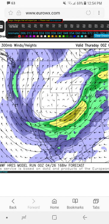
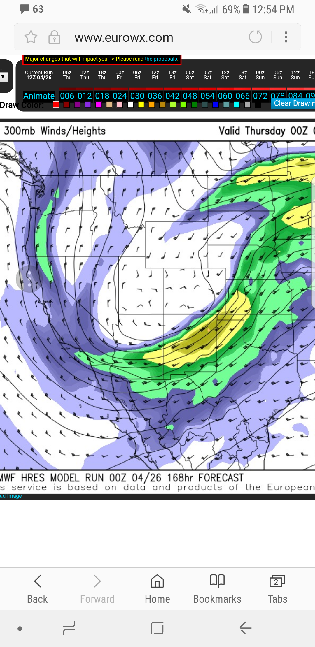
I just figured it out. My apologies. Was kinda confusing at first. I'm new to the site. But it has a bar up top showing the progress and shows the run at the bottom. I swear I'm not an idiot. Just had a blonde moment. Lol -
Central/Western Medium-Long Range Discussion
Radtechwxman replied to andyhb's topic in Central/Western States
Then why in the corner does it say 12z Thurs current run?? Where it says valid 0z Thurs is actually the time frame I'm looking at. Wed night -
Central/Western Medium-Long Range Discussion
Radtechwxman replied to andyhb's topic in Central/Western States
Hopefully won't get in trouble for posting this. Winds aloft not looking as westerly as before. Jet has more amplitude this time around and not as flat