

cyclone77
-
Posts
17,686 -
Joined
-
Last visited
Content Type
Profiles
Blogs
Forums
American Weather
Media Demo
Store
Gallery
Posts posted by cyclone77
-
-
8 hours ago, CheeselandSkies said:
SPC mentions it, too (Saturday Day5 highlight for NE/w IA is pretty gutsy in August IMO). 06Z GFS has any potential for Sunday way east of us.
12z Euro still looking pretty nice. Nice little vort max rolling in around peak heating. Hope the Euro is on the right track.
")
-
 2
2
-
-
New Euro shows a pretty decent severe threat Sunday/Sunday night from WI/IL points east. Next thing to watch for sure.
-
1
-
-
1 hour ago, OrdIowPitMsp said:
Had no idea there was smoke in the region today. Considering myself lucky the sky looks like this here.

That sugar maple looks a little young to be crapping out already.
Deep blue skies here as well, with some towers going up. A few isolated downpours have popped up in the heat of the day.
-
Today's near 70 degree dews feel like fresh canadian air compared to yesterday's oppressive lower 80s.
-
3
-
-
A moderate risk would definitely have worked out quite well this evening. Fairly dense population of severe reports showing up as the evening progresses.
-
Today's 0.66" brings us up to about 4.5" for July. The drought is a distant memory now.
-
Today's 96 at MLI was the 28th day AOA 90 this year.
-
1
-
-
55 MPH quality gust front. Enough to be entertaining and don't have to worry about a massive cleanup.

Heavy rains arriving now. Temp has crashed over 20 degrees.
-
1
-
-
Sirens going off here with the emergency notification blasting everyone's phones. Good shot at 70-80mph from the looks of things, especially just north.
-
2
-
-
1 minute ago, SchaumburgStormer said:
One of the few times I am happy to be missed at the moment. Nearly an inch this morning plus some serious dumping later tonight will be enough. Going to be some 6+” totals somewhere in the metro
Yeah this flash flood threat is definitely pretty high end. These storms are lined up parallel with the swath of highest PWs, north of 2". Some seriously high totals I'm afraid for some peeps.
-
On 7/27/2023 at 6:30 PM, cyclone77 said:
Ready 2b derechoed

-
2
-
 1
1
-
-
Dew up to 84 at Sterling. Think that's legit too as it doesn't seem to usually have a high bias, and there's a lot of farmland around this whole area.
-
Marshalltown Iowa ASOS just gusted to 93mph.
-
Pretty tough conditions IMBY currently with 95/81/117. The corn is a sweatin'.
-
Thunder crashing woke me up around 4am. Picked up a few tenths which pushes us up over the 4" mark for July.
Looking forward to the action later today/this evening.
-
2
-
-
8 minutes ago, MNstorms said:
This storm has constant flickering. Seeing probably 5-10 a second. Not sure if I've seen so much lightning.

Yeah that's a very prolific lightning producer to be sure.
-
Heat index in Peoria is still 104 with the new midnight ob (86/82). The wind is nearly calm too so it would not be a good night to be out camping or having a bonfire lol.
EDIT: Still 104 heat index at 1am ob.

-
 1
1
-
-
2 minutes ago, Chinook said:
for those who like insane CAPE
.gif.771f6bf674127f85ae7d6bf1eb9f91cb.gif)
The ILX sounding near Springfield IL had over 6600J/kg on this evening's sounding.
-
On 7/24/2023 at 10:38 PM, cyclone77 said:
DVN has 100 in the point for Thu at MLI, 99 on Friday.
We still haven't made a run at an 80 degree dewpoint yet, which is kind of unusual. Looking like there's a good chance we won't make it this year.
Spoke too soon about this lol. 2nd day in a row with a 78 dew. Good chance we hit 80 tomorrow. Nice pool of 80-83 dews lurking just to the south/southwest.
-
1
-
-
Ready 2b derechoed
-
3
-
 2
2
-
-
MLI hit 96 today which ties for the hottest to date so far. Morning clouds in the wake of the convection knocked a degree or two off the potential today.
-
Dewpoint up to 78, the highest of the summer so far.
Picked up 0.13" this morning, up to 3.82" for July.
-
Nice area of elevated action heading this way, putting out a lot of strokes. Ready for some rumbles before baking this afternoon. Gonna be sweating like Patrick Ewing in the 4th quarter lol.
-
1
-
2
-
-
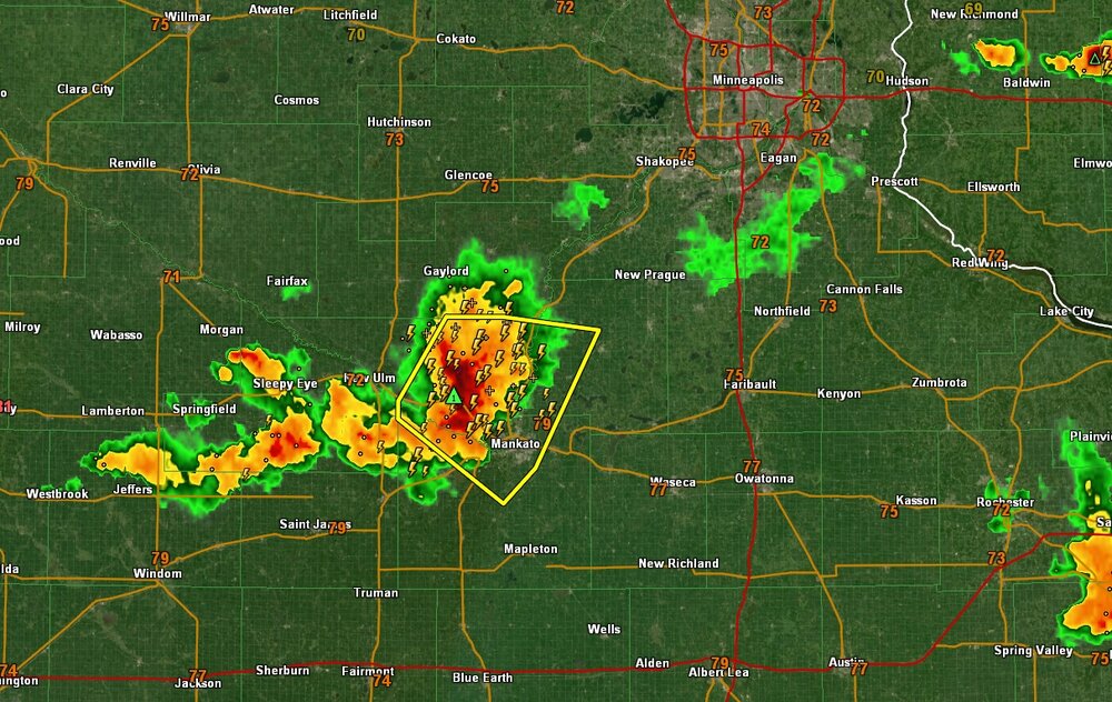
Minneapolis run of bad luck with regards to action is about to end. Nice well organized severe bow echo taking dead aim on the metro.
-
2
-

2023 Short/Medium Range Severe Weather Discussion
in Lakes/Ohio Valley
Posted
Hopefully the new day4 introduces a risk area, and it looks like this.