nwohweather
-
Posts
3,818 -
Joined
-
Last visited
Content Type
Profiles
Blogs
Forums
American Weather
Media Demo
Store
Gallery
Everything posted by nwohweather
-

Pre-Christmas (Dec 21-23rd) Winter Storm Part 2
nwohweather replied to Chicago Storm's topic in Lakes/Ohio Valley
The rare last minute improvement for the region. Still if you go off the models verbatim it's 7-10" on the GFS and 2-4" on the NAM, not great disagreement this close to snowfall -
Pre-Christmas (Dec 21-23rd) Winter Storm Part 2
nwohweather replied to Chicago Storm's topic in Lakes/Ohio Valley
I don’t think I’ve ever seen it snow at that temperature before to be honest, have to admit I think the coldest I’ve ever seen snow fall was around 10° -
Pre-Christmas (Dec 21-23rd) Winter Storm Part 2
nwohweather replied to Chicago Storm's topic in Lakes/Ohio Valley
Well for maybe the first time ever, the trend is our friend in Toledo -
Pre-Christmas (Dec 21-23rd) Winter Storm Part 2
nwohweather replied to Chicago Storm's topic in Lakes/Ohio Valley
10 MB as well -
Pre-Christmas (Dec 21-23rd) Winter Storm Part 2
nwohweather replied to Chicago Storm's topic in Lakes/Ohio Valley
Crazy to see the latest trends on the models, I'd throw up Blizzard Warnings for all of IWX at this point and probably all the way over to Jackson and possibly even Ann Arbor. I think you almost have to be over dramatic here considering the importance of this time of year during travel and the fact that this storm is a combo of a high end tropical storm wind with snow. For NW Ohio at the moment it seems like a safe call to go with 5-8" for the counties west of I-75 and 3-5" for everywhere to the east. This thing absolutely gets ripping late Thursday and by early Friday morning the entire region is shut down probably until Sunday morning. -
Pre-Christmas (Dec 21-23rd) Winter Storm
nwohweather replied to Chicago Storm's topic in Lakes/Ohio Valley
What an absolute snowstorm for Northern IN & Michigan. 25-35 mph winds sustained during the height of the snow with gusts as high as 60 mph possible. Could see some unreal drifts and places paralyzed for at least a week -
Pre-Christmas (Dec 21-23rd) Winter Storm
nwohweather replied to Chicago Storm's topic in Lakes/Ohio Valley
Looks like a solid 2-4” for Toledo with 3-6” around Defiance and the western border counties. It’s going to be pure awesomeness to see that front roll through with that amount of cold and wind. Good time to be in Northern IN, NE Illinois, and really all of Michigan and Wisconsin. True definition of a blizzard in every sense, would not be shocked to see severe thunderstorm level gusts when this thing really begins to bomb out -
Winter 2022/23 Medium/Long Range Discussion
nwohweather replied to Chicago Storm's topic in Lakes/Ohio Valley
It’s beginning to look a lot like Christmas… -
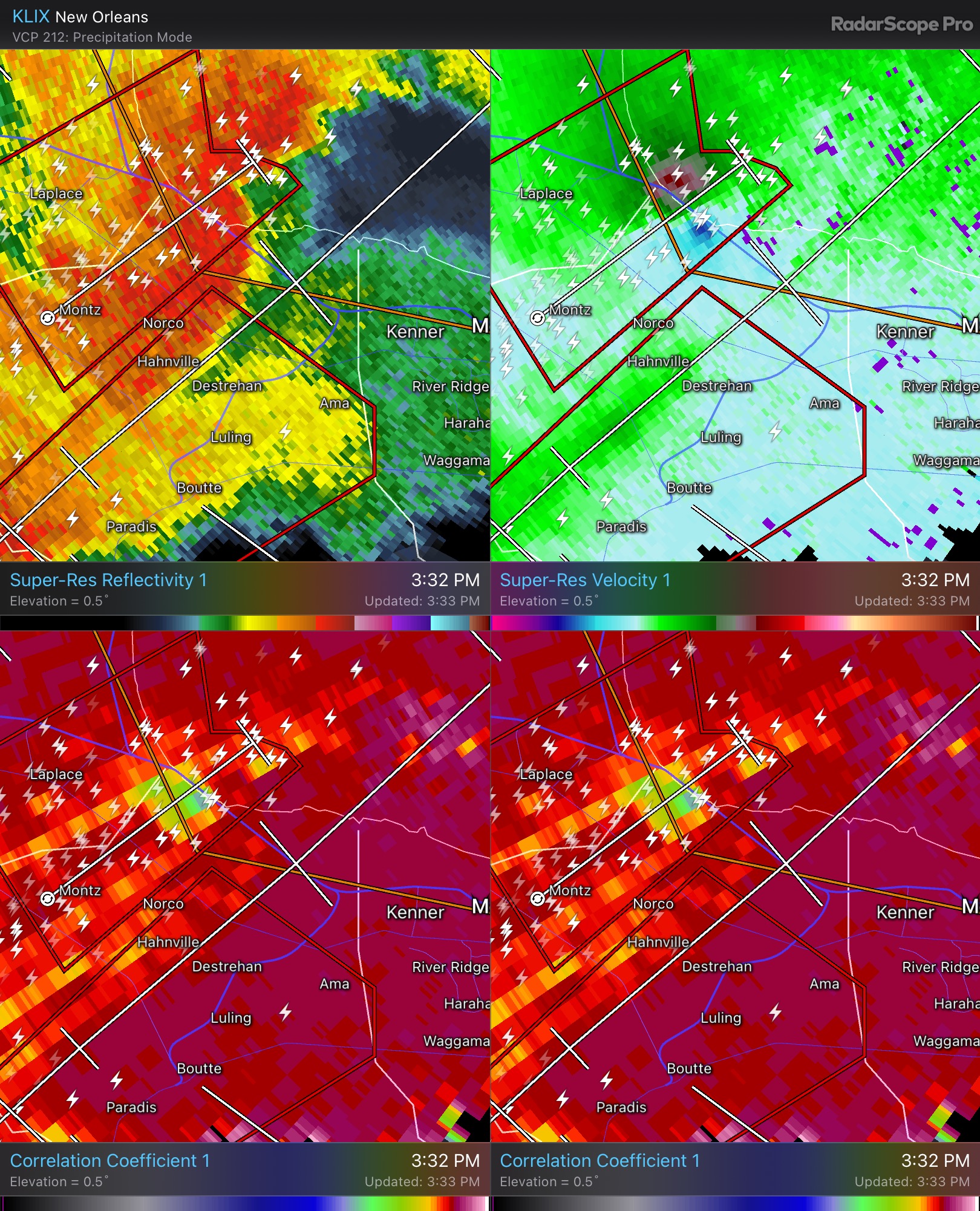
Furiously scanning Twitter at the moment. Looks like a solid tornado from the few videos posted. Heavily rain wrapped though, this definitely isn’t Oklahoma
-
Tornado Emergency has to be going up soon
-
Oh my God that thing is heading straight for the city
-
Noticeably higher amounts of instability, helicity and ground scraping cloud levels in that area. I’d definitely stay the hell off the causeway right now
-
Damn just west of Kenner. Very densely populated just to the east

-
I think we're about 2 hours away from primetime. I'd like the SRH to build a little more and the dewpoints to creep up a bit
-
11/29/22 MDT Outlook Issued -- Regional outbreak possible.
nwohweather replied to CryHavoc's topic in Central/Western States
Definitely wasn’t an all time day but still we’re at 17 tornadoes for the day and more than likely an EF3 east of Columbus AFB -
Most people in the central and western thread
-
11/29/22 MDT Outlook Issued -- Regional outbreak possible.
nwohweather replied to CryHavoc's topic in Central/Western States
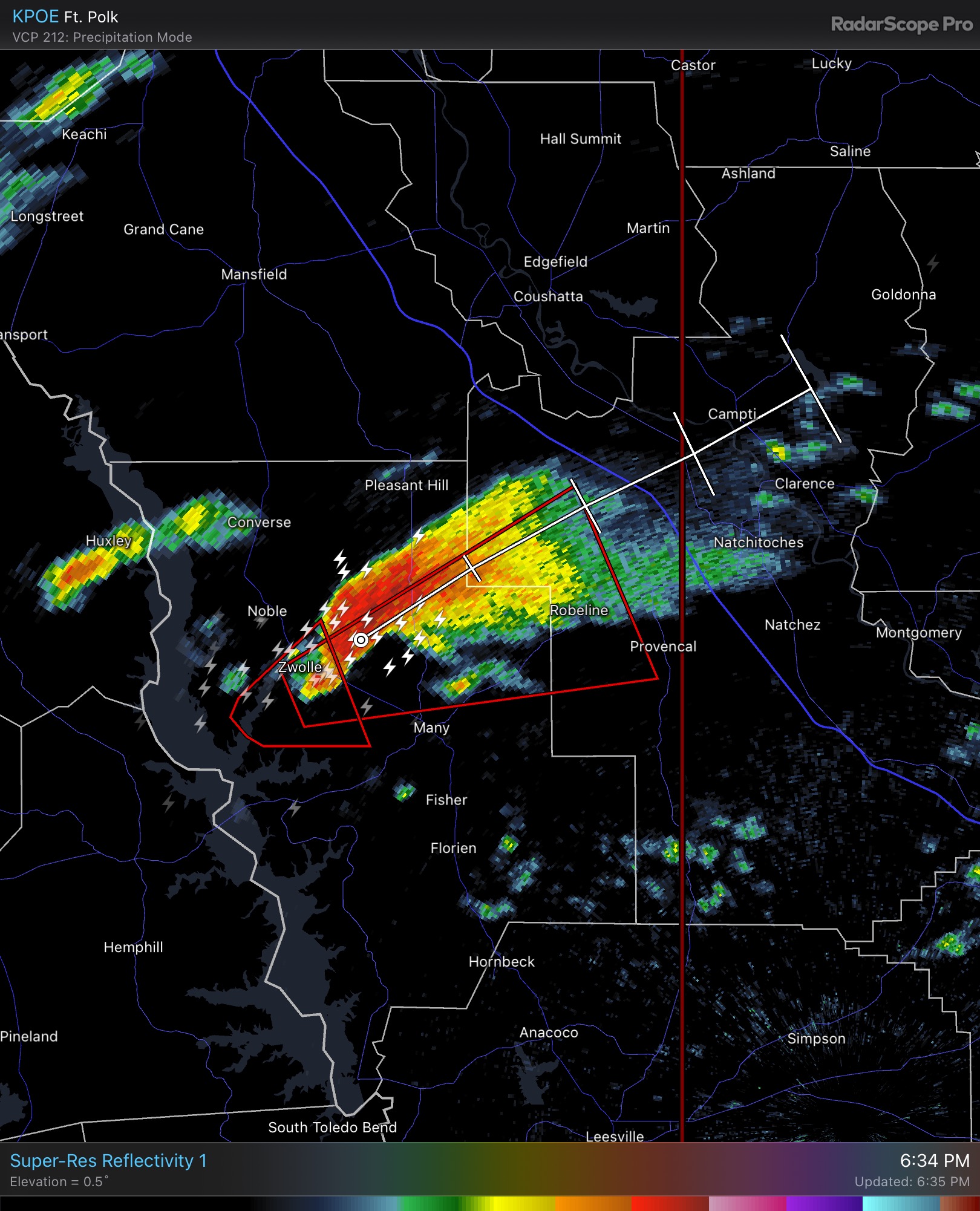
Wow look at the form on this one west of Natchitoches. Great environment as well with ample instability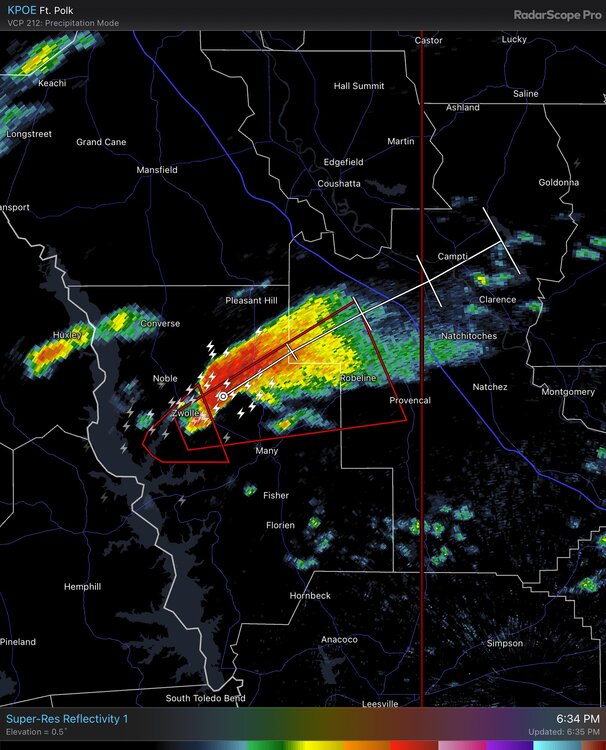
-
11/29/22 MDT Outlook Issued -- Regional outbreak possible.
nwohweather replied to CryHavoc's topic in Central/Western States
To me it almost looks like even though the storm mode is messy there is simply such good dynamics everything is going to spin as much as it can. I’m interested to see if anyone can get a pic of that Bassfield tornado -
11/29/22 MDT Outlook Issued -- Regional outbreak possible.
nwohweather replied to CryHavoc's topic in Central/Western States
If the storm mode could clean up a bit today could get really dicey, they all have that look for sure but no clean inflow at this time. Watching the one south of Jackson closely -
Would we be able to merge threads as this is sort of a cross regional situation?
-
11/29/22 MDT Outlook Issued -- Regional outbreak possible.
nwohweather replied to CryHavoc's topic in Central/Western States
Jesus, essentially a 4/27/11 redux on that model, just a state to the left -
11/29/22 MDT Outlook Issued -- Regional outbreak possible.
nwohweather replied to CryHavoc's topic in Central/Western States
First one in 20 months if it happens -
11/29/22 MDT Outlook Issued -- Regional outbreak possible.
nwohweather replied to CryHavoc's topic in Central/Western States
Now saying this... "Multiple rounds of severe thunderstorms -- some capable of long-tracked tornadoes with EF3+ damage potential -- will be possible this afternoon into tonight over parts of the lower Mississippi Valley region and Mid-South." Two things that really stick out to me is the lapse rates (pretty high for the mid South) and very high SRH. You're going to see some strong updrafts over there today with quick storm motions, just a perfect combo for long track tornadoes. -
11/29/22 MDT Outlook Issued -- Regional outbreak possible.
nwohweather replied to CryHavoc's topic in Central/Western States
I’ve noticed this too. To be fair my western Ohio self has seen too many tornadoes and derechos to not love severe weather. What concerns me with this event is you have a strong deepening low giving us a jet that is going to be absolutely howling. As long as lapse rates don’t get too bad we could see some serious tornadoes tomorrow -
Dear God it's 72° at my house right now, my body may shut down As I mentioned before I wouldn't be shocked to see something to 2017 where it was a clipper train for the 1st half of the month and had a few snowstorms on the back half. Heck on the 28th we got down to -8° at Toledo Express