USCAPEWEATHERAF
-
Posts
8,736 -
Joined
-
Last visited
Content Type
Profiles
Blogs
Forums
American Weather
Media Demo
Store
Gallery
Everything posted by USCAPEWEATHERAF
-
 A lot of signs point to a potentially damaging wind event, right now parameters are not as supportive as we want, but models show storm potential as a monster low makes it path across ME into the Gulf of Maine. Could be quite strong winds in convection and then the backside of the low could deliver very cold air and winds off the ocean. Also, our prayers go out for Jefferson City, MO residents and everyone who has gone through these tornadoes yesterday and this morning.
 -
Hey everyone, I am in the workings of creating a creative business that focuses on ideas and making them into stories to tell the world. I am focused on working on a novel and get that published first. I have a partner now. Not official yet, but in the process of working the kinks out. We are going to make a novel series and perhaps make movies after each novel in the franchise that now has a name, "The Awakening Dawn" series. Each of the three novels has titles now, they are still working titles, and are subject to change. 'The Awakening Dawn" 9Book one), "From Dawn Until Dusk" (Book Two), "The End of the Awakening" (Book Three). These novels will continue the story of the main characters, Jack Irving (25 year old hurricane specialist), Abi Acheson/Irving (Jack's fiancee in book one and wife throughout the rest of the story), Michael Reed (Jack's best friend since Kindergarten) and Marie Givens (Mike's girlfriend and wife later on and bosses daughter in book one). Secondary characters who appear in every novel: Jack's family members: Daniel Irving (Brother), Sarah Irving (sister, unsure her future), Siobhan Irving (Jack's youngest sister), Edith Irving (Jack's mother, dies from pancreatic cancer in book one), William Irving (Jack's father, lives in all three books). Other characters include Abi's best friend and secretary, USAF Reserve 53rd WRS hurricane hunter pilot Major/Lt. Colonel Brooks Carter and his crew. And others... Next project and potential big-time franchise novel/movie series... 'The Terroristic Behavior Series" This is a story about a duel between a CIA trained assassin turned into terror suspect who terrorizes the US's world interests, many mysteries exist and are unraveled as the story goes on as former terror expert and ghost hunter, FBI special agent Sebastian Jenkins who is recently divorced and has three children. He is hired by the FBI again or transferred to GHOST PROTOCOL. He is hunting a person the government of the US considers a ghost. The story lasts three novels and shows potential to become a big-time movie franchise. Characters include Carter Avril - ghost, and Sebastian Jenkins Ghosthunter. Still a work in progress in terms of character development and story development. There are other individual projects considered as well that could provide to the workload. This is for the far future to determine. James Warren Nichols/Kyle Bass
-
"The Awakening Dawn" Novel Update
USCAPEWEATHERAF posted a blog entry in Once a legend always a legend
Working on a new draft should be done within a month's time, getting better at telling the story I want to tell. -
Yeah a perfect night of slop snow, sleet and rain all combined for a total accumulation of coating of snow. Our best storm so far this season is 4" of snow.
-
Sleet has started after a coating of wet snow.
-
No but what I mean is that normally storms pre-event have pressures quite high north of the low like over 1020mb
-
The surface center of our storm is broad and low, around 1008mb over a large area, and as low as 1006mb over the GA/SC border.
-
Also there pressure field all over the East Coast is quite low, around 1019mb here in Harwich.
-
Rain, likely. I think the storm track is still uncertain until the storm hits the coastline. Right now the greatest pressure falls/3 hours is just off the NE North Carolina coast, right off of Cape Elizabeth, NC, of around 5mb/3 hours
-
While I need to be more objective, this storm is getting colder on observations down south. I think we should lean towards a colder scenario across SNE. Does that mean Harwich sees more snow than 3-5", I don't know yet.
-
Our storm center is strengthening, down to 1004.9mb, over the NE GA and NW SC border looks southeast of the models.
-
35F/30F, Harwich, MA
-
Perhaps a Coastal Storm on March 2nd for SNE????
USCAPEWEATHERAF replied to USCAPEWEATHERAF's topic in New England
I should have stayed with a max of 10" not gone and increased it to 16" -
Perhaps a Coastal Storm on March 2nd for SNE????
USCAPEWEATHERAF replied to USCAPEWEATHERAF's topic in New England
I'm heading to bed, waking up in a few hours to check on the storm's progress. Hopefully, the GFS is right with this storm. -
Perhaps a Coastal Storm on March 2nd for SNE????
USCAPEWEATHERAF replied to USCAPEWEATHERAF's topic in New England
I wouldn't worry about that unless the 00z GFS comes in agreement. -
Perhaps a Coastal Storm on March 2nd for SNE????
USCAPEWEATHERAF replied to USCAPEWEATHERAF's topic in New England
Yes but the greatest pressure fall couplet, is over Norfolk, and SE Virginia. -
Perhaps a Coastal Storm on March 2nd for SNE????
USCAPEWEATHERAF replied to USCAPEWEATHERAF's topic in New England
Be patient, the main development is just getting underway, between 3-6z is when the low really starts to take off right off the Delmarva. -
Perhaps a Coastal Storm on March 2nd for SNE????
USCAPEWEATHERAF replied to USCAPEWEATHERAF's topic in New England
Greatest pressure falls as of this hour are over Norfolk and the SE Virginia region, not over Cape Hatteras, NC, that means the low may be developing further northward. -
Perhaps a Coastal Storm on March 2nd for SNE????
USCAPEWEATHERAF replied to USCAPEWEATHERAF's topic in New England
I would say around 3-6z tongiht is when the crucial part of the surface low development and track come into play as the convection matures off the coast, that is when the models pivot the low more northward then eastward. Patience everyone, soon the satellite will look like its supposed to with the low moving up the coast. -
Perhaps a Coastal Storm on March 2nd for SNE????
USCAPEWEATHERAF replied to USCAPEWEATHERAF's topic in New England
There is good news on satellite imagery, the line of thunderstorms east of NC are actually developing much closer to the coast of Cape Hatteras. -
Perhaps a Coastal Storm on March 2nd for SNE????
USCAPEWEATHERAF replied to USCAPEWEATHERAF's topic in New England
Scott if it helps any, the precipitation in bands is moving NNEward -
Perhaps a Coastal Storm on March 2nd for SNE????
USCAPEWEATHERAF replied to USCAPEWEATHERAF's topic in New England
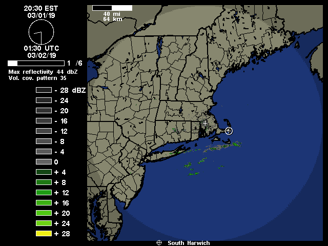
Yeah I can barely stay awake right now, I need to be awake for when the snow starts up tonight. Bands already moving past ACK, but ACK is not reporting any precipitation, not sure what the official observations say, Brian can you check that out when you get a chance. -
Perhaps a Coastal Storm on March 2nd for SNE????
USCAPEWEATHERAF replied to USCAPEWEATHERAF's topic in New England
No the EURO and GFS have been quite steadfast, unless you are talking about heavy snow potential areas west of I95 corridor. I think Hartford, CT is in trouble and less confidence. -
Perhaps a Coastal Storm on March 2nd for SNE????
USCAPEWEATHERAF replied to USCAPEWEATHERAF's topic in New England
I agree. They were a step in the right direction and so was the 2z HRRR model run, they are slowing down the progress of the storm. -
Perhaps a Coastal Storm on March 2nd for SNE????
USCAPEWEATHERAF replied to USCAPEWEATHERAF's topic in New England
Low-level bands developing out ahead of the main storm, down in NC.