SnowGoose69
-
Posts
16,752 -
Joined
-
Last visited
Content Type
Profiles
Blogs
Forums
American Weather
Media Demo
Store
Gallery
Everything posted by SnowGoose69
-
Depends, it may be hooking somewhat hard at LF so I think if it comes in over SRQ its probably missing metro TB, if it comes in N of metro Sarasota then definitely it could hit eastern side of the metro
-
ICON ticked back north again
-
The biggest concern for Tampa so far is the HAFS-A/B and HWRF still take this in over Clearwater or north and they were fairly close in the last storm
-
My memory has gotten really bad. I probably want to forget that week since for a good day all the models had it hitting New York City then in one shot they all moved south
-
Isabel i believe never came close to its initial peak strength. I was working that week and recall it made it back to maybe a a weak 3 but that was all
-
I’ve never seen a cat 4 or 5 have a second peak after an ERC higher than the first from what I remember. It’s probably happened at some point but it’s rare
-
Euro landfall looks like around St Pete beach
-
Its a small storm so an ERC which appears likely in the next 18-24 hours likely takes it to a 2-3, it may then strengthen again slightly but probably remains a 3, it should then get impacted by shear. I think it comes in between 110-130mph
-
I don't think we see that significant of a track error, it'll probably make deviations E once it feels the impact of the land mass and miss. I could see it coming within 20-30 miles but not moving onshore
-
The shear direction continues to be problematic based on storm movement. I am not sure 25kts at shear from 215 is going to be enough to have a meaningful weakening impact
-
What I never understood about small storms with small eyes is why they rapidly strengthen but that they seem to weaken way more following ERCs than big storms do. You’d think it would be the opposite of that but you think of Patricia or Opal those things straight up got killed by ERCs. Then again both also made landfall soon after so we don’t really know if they had another day or two over water what might have happened
-
No big change on 18Z Euro, directly into Tampa
-
HAFS B looks as if it'll take a south jog this run, storm noticeably has expanding wind field as its approaching coast
-
I'd think it definitely would not have enough time, we can assume an ERC happens or shear to some degree knocks it down close enough to landfall it likely peaks awhile before coming ashore
-
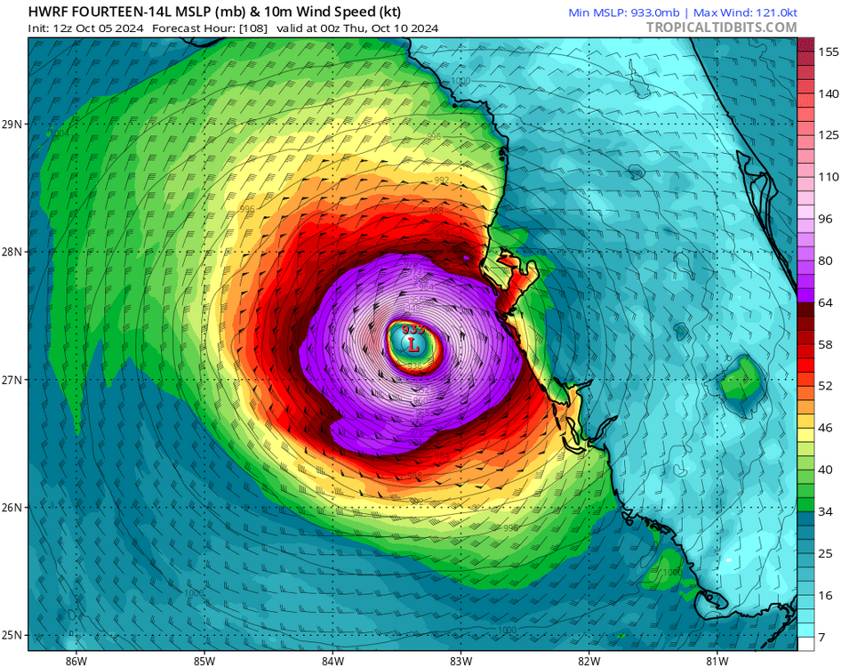
The HWRF is still north of Tampa by 20-40 miles
-
Which is just unrealistic in my mind, either the strongest point is too strong or the weakening is probably overdone
-
The ICON was remarkably good with the track of Helene, it was overall a bit too far SE at this range but in the final 72 was close
-
As far as wind damage the ideal location for this to come in probably is around Venice or N of Crystal River. Once inland of those 2 locations you have to go for miles for any significant pop centers. As far as surge, you'd be bringing bad surge into Tampa on the N track and into Charlotte Harbor on the S track
-
The north side of Helene didn’t have too extensive an area of big winds. It was mostly on the SE side. This storm it shouldn’t be as bad since it’s not going to be moving as fast. Places like Palm Beach and Fort Lauderdale might be the biggest beneficiaries if this comes in over Sarasota or just south. With Helene they’d have seen 80 mph gusts. They should be 45-55 based on 925 winds on the globals with this which shouldn’t be a problem outside shutting down all 3 airports as that’s a 70-80 degree crosswind from 200-210
-
I think it’s still likely landfall ends up down near Sarasota or a tad south of that. We should see models move that way next 24 hours. Part of that reasoning is they are showing a harder SE movement next day or so
-
-
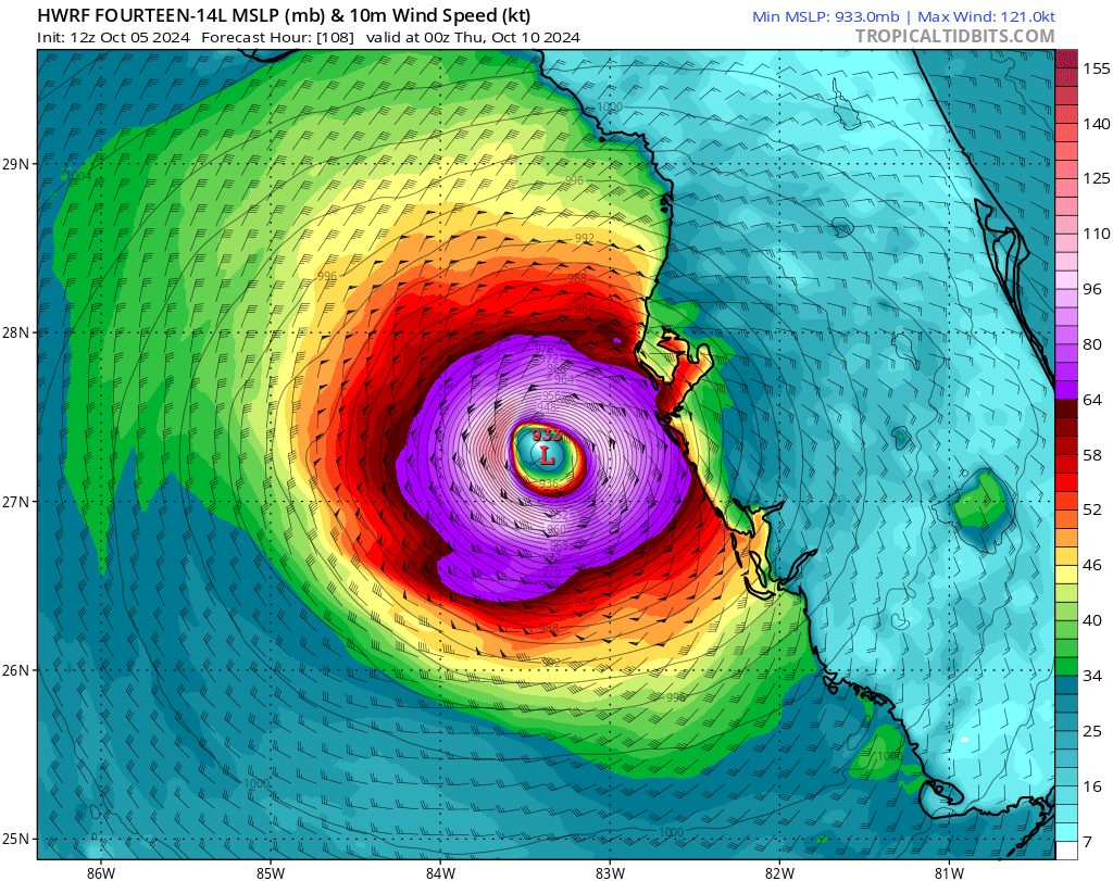
HWRF directly into Tampa at 933mb
-
I guess the good news with those HMON/HAFS tracks is the population is way lower where they bring the storm in
-
06z Euro is much slower than the 00Z but it may have ended up close to the same location of landfall in the end
-
GA I think had more in Irma and Zeta, about 1.2 and 1.1 but that was sort of skewed by the fact ATL metro was impacted, this time they likely account for under 200K of those outages