SchaumburgStormer
-
Posts
5,690 -
Joined
-
Last visited
Content Type
Profiles
Blogs
Forums
American Weather
Media Demo
Store
Gallery
Everything posted by SchaumburgStormer
-

1/8-1/10 Potential Winter Storm
SchaumburgStormer replied to Thundersnow12's topic in Lakes/Ohio Valley
GFS tossing more drool worthy stuff for IL. I would love to get this one, like the old times, where the NAM is throwing us just stupid clown maps within 24 hours. But again, we’ve seen this game before. If we follow the multi-season trend, we have about 48 more hours of model enjoyment before every post becomes “south/flatter/weaker”. -
1/8-1/10 Potential Winter Storm
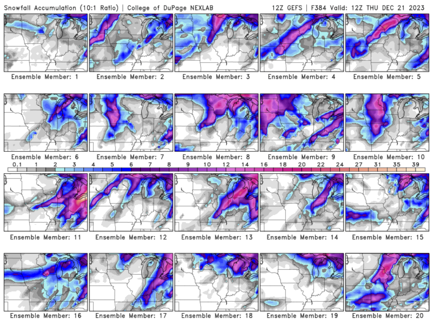
SchaumburgStormer replied to Thundersnow12's topic in Lakes/Ohio Valley
Pretty good representation of all the OP run solutions we have seen over the past few days. -
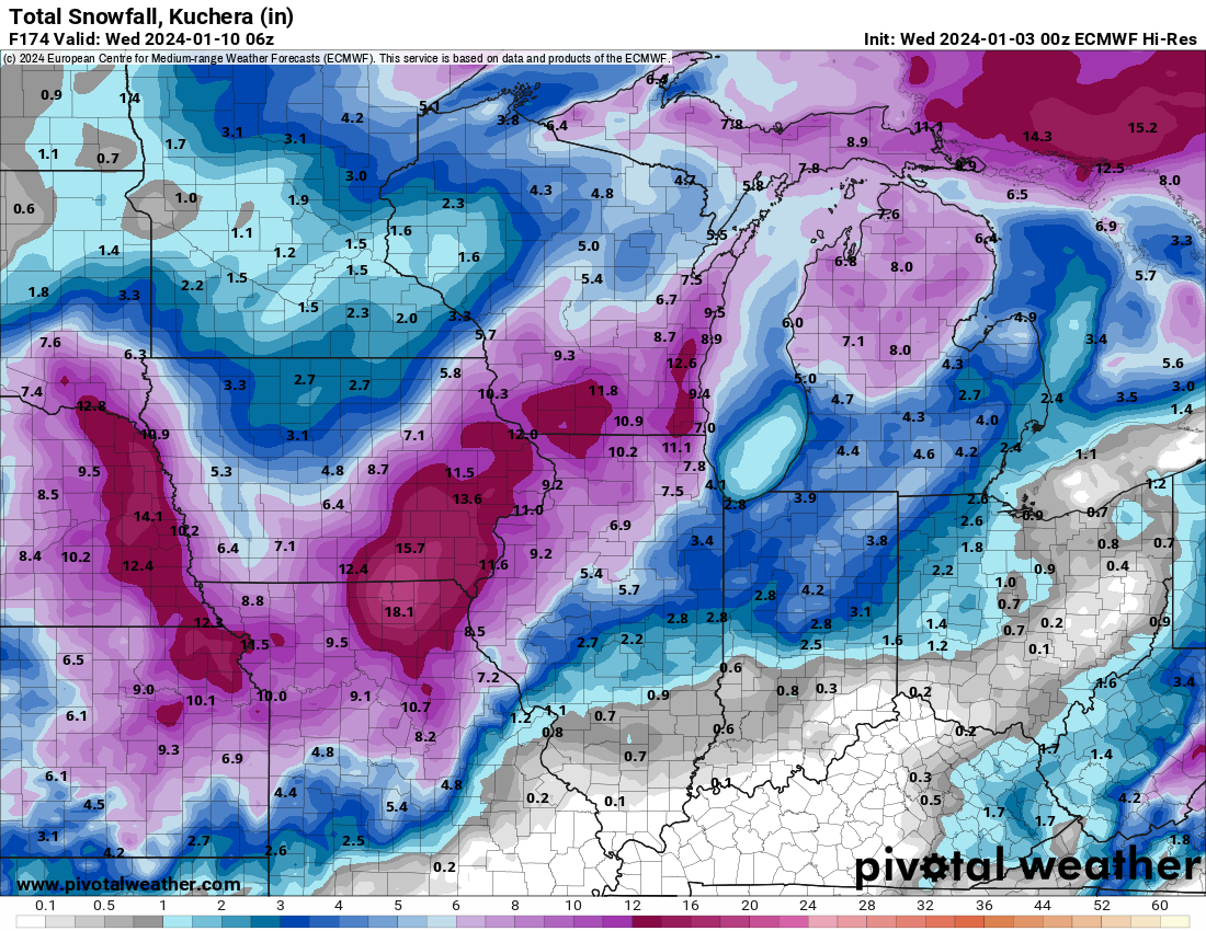
1/8-1/10 Potential Winter Storm
SchaumburgStormer replied to Thundersnow12's topic in Lakes/Ohio Valley
Euro would have alek posting the eurythmics while SE Iowa to NW IL get smoked. Most of LOT would do solid. Models have been rug pulling for so long that it’s tough to buy in at this range, agreement or not. edit- forgot the image
-
Winter '23-'24 Piss and Moan/Banter Thread
SchaumburgStormer replied to IWXwx's topic in Lakes/Ohio Valley
Was CRUSHED with 1.7” out of that WSW -
Winter 2023/24 Medium/Long Range Discussion
SchaumburgStormer replied to Chicago Storm's topic in Lakes/Ohio Valley
Top notch. Appreciate the insight as always. Nice break to the “warm” and “ban him” bickering. -
December 2023 General Discussion
SchaumburgStormer replied to michsnowfreak's topic in Lakes/Ohio Valley
Made it down to 12 last night. With the recent "warmth" the air had a bit more bite than expected when I walked outside today. -
Winter '23-'24 Piss and Moan/Banter Thread
SchaumburgStormer replied to IWXwx's topic in Lakes/Ohio Valley
2015-2016 was abysmal if I recall correctly. Was the first of 2 back to back sub-20" winters, and I don't think I got my first inch of snow until late January. -
December 2023 General Discussion
SchaumburgStormer replied to michsnowfreak's topic in Lakes/Ohio Valley
No, they died in 2015 -
December 2023 General Discussion
SchaumburgStormer replied to michsnowfreak's topic in Lakes/Ohio Valley
Minus the stomach bug, this sounds glorious. Tons of snow, packers losing -
Winter 2023/24 Medium/Long Range Discussion
SchaumburgStormer replied to Chicago Storm's topic in Lakes/Ohio Valley
No... When we are ready for Spring to arrive we will get stuck with an extra month of shitty winter weather. April snowiest month incoming. -
The rug pull of all rug pulls. Models are seemingly worse at 120 hrs than they were a few years ago. GFS "improvements" have really turned it into a steaming shit pile.
-
Winter '23-'24 Piss and Moan/Banter Thread
SchaumburgStormer replied to IWXwx's topic in Lakes/Ohio Valley
Already up to 10” of GFS imaginary snow. -

-

-
Seems like both the GFS and Euro are wanting to take the low right over the CWA. Cold air ends up late to the party. Ensembles are still all over the freaking place with some well north and some well south. Could be in worse positioning as this one gets dialed in.
-
Winter 2023/24 Medium/Long Range Discussion
SchaumburgStormer replied to Chicago Storm's topic in Lakes/Ohio Valley
You know, a casual 250 mile shift between runs. I wouldn't get too excited about anything... And until I see something that changes it, I am riding the "weaker, south, strung out" multi-year trend. -
Winter 2023/24 Medium/Long Range Discussion
SchaumburgStormer replied to Chicago Storm's topic in Lakes/Ohio Valley
Yeah the 00z Euro was pretty wild locally, GFS well east with the system. -
December 2023 General Discussion
SchaumburgStormer replied to michsnowfreak's topic in Lakes/Ohio Valley
Ready for my 217” of fantasy GFS snow this season -
November 2023 General Discussion
SchaumburgStormer replied to cyclone77's topic in Lakes/Ohio Valley
Creeping northward…
-
November 2023 General Discussion
SchaumburgStormer replied to cyclone77's topic in Lakes/Ohio Valley
The “storm” Saturday night into Sunday looks a bit juicier than I was expecting. With nowhere to go this weekend will be nice to see some flakes. -
Winter 2023-24 Longrange Discussion
SchaumburgStormer replied to michsnowfreak's topic in Lakes/Ohio Valley
FYP. -
November 2023 General Discussion
SchaumburgStormer replied to cyclone77's topic in Lakes/Ohio Valley
ILX with a fantastic write up https://storymaps.arcgis.com/stories/b13d60d65c434d63a915cc7a88afa6fd -
Fall 2023 Medium/Long Range Discussion
SchaumburgStormer replied to Chicago Storm's topic in Lakes/Ohio Valley
Definitely looks like we switch right into more winter like temps early next week. -
November 2023 General Discussion
SchaumburgStormer replied to cyclone77's topic in Lakes/Ohio Valley
Top notch weather for November on tap for today. Yesterday was not terrible either, but some sunshine would have gone a long way. Was able to finish the winter lawn/garden clean out, which I had been putting off for some time.