SchaumburgStormer
-
Posts
5,847 -
Joined
-
Last visited
Content Type
Profiles
Blogs
Forums
American Weather
Media Demo
Store
Gallery
Everything posted by SchaumburgStormer
-

4/25-4/28 Severe and Heavy Rain Threat
SchaumburgStormer replied to Geoboy645's topic in Lakes/Ohio Valley
Rain wrapped too. -
4/25-4/28 Severe and Heavy Rain Threat
SchaumburgStormer replied to Geoboy645's topic in Lakes/Ohio Valley
Yikes, she’s chewing.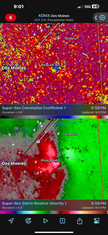
-
4/25-4/28 Severe and Heavy Rain Threat
SchaumburgStormer replied to Geoboy645's topic in Lakes/Ohio Valley
-
4/25-4/28 Severe and Heavy Rain Threat
SchaumburgStormer replied to Geoboy645's topic in Lakes/Ohio Valley
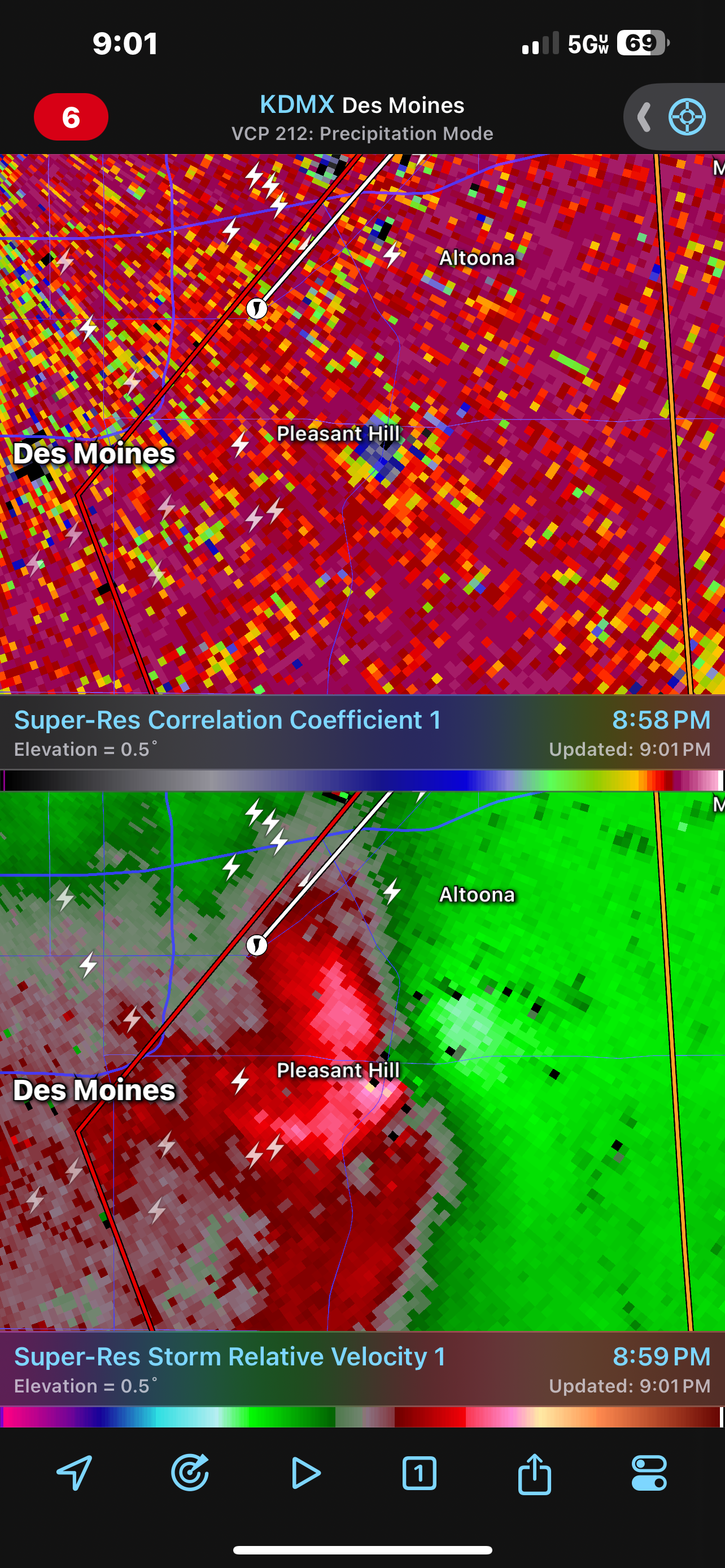
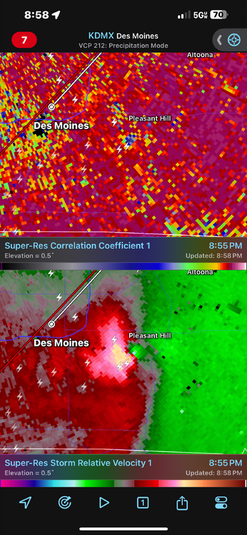
TOG east of Des Moines -
4/25-4/28 Severe and Heavy Rain Threat
SchaumburgStormer replied to Geoboy645's topic in Lakes/Ohio Valley
Storm near Osceola looks nasty -
April 2024 General Discussion
SchaumburgStormer replied to PositiveEPOEnjoyer's topic in Lakes/Ohio Valley
Yep dropped to 26 IMBY. Wasn’t expecting it to go quite that low -
April 16-17 Severe Weather Event
SchaumburgStormer replied to nwohweather's topic in Lakes/Ohio Valley
At least 1 tor confirmed in central IL last night thus far -
April 2024 General Discussion
SchaumburgStormer replied to PositiveEPOEnjoyer's topic in Lakes/Ohio Valley
Its nice to be back at the time of the year where a "cold" shot still leaves us in the upper 50's for highs. -
April 16-17 Severe Weather Event
SchaumburgStormer replied to nwohweather's topic in Lakes/Ohio Valley
Rocking some pretty solid wind gusts in that area as well -
April 16-17 Severe Weather Event
SchaumburgStormer replied to nwohweather's topic in Lakes/Ohio Valley
Blanket tornado warning on that big line on S IL. -
April 2024 General Discussion
SchaumburgStormer replied to PositiveEPOEnjoyer's topic in Lakes/Ohio Valley
Planted a bunch of peas over the weekend, can use the rain and if we avoid the frost over the weekend that would be golden -
April 16-17 Severe Weather Event
SchaumburgStormer replied to nwohweather's topic in Lakes/Ohio Valley
Whole lot of “meh” so far -
Spring 2024 Medium/Long Range Discussion
SchaumburgStormer replied to IWXwx's topic in Lakes/Ohio Valley
This cool down appears to be moderating as we get closer as well. Getting into the season where full sun will push you to overperform by 2-3 degrees. -
April 2024 General Discussion
SchaumburgStormer replied to PositiveEPOEnjoyer's topic in Lakes/Ohio Valley
Extended looks to be seasonal or slightly above. No significant cold to speak of, green up will be off to the races. -
4/2-4/3 Significant Late-Season Snowstorm (WI/MI)
SchaumburgStormer replied to Geoboy645's topic in Lakes/Ohio Valley
Snow globing, but melting on contact now. -
4/1-4/2 severe threat (southern portion of subforum)
SchaumburgStormer replied to largetornado's topic in Lakes/Ohio Valley
Things seem to be “meh” across Illinois so far this evening -
4/1-4/2 severe threat (southern portion of subforum)
SchaumburgStormer replied to largetornado's topic in Lakes/Ohio Valley
Another storm west of STL looking nasty too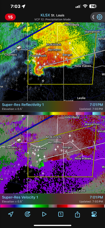
-
March 2024 General Discussion
SchaumburgStormer replied to MazooWeather's topic in Lakes/Ohio Valley
9" report coming out of Rockford within the band -
March 2024 General Discussion
SchaumburgStormer replied to MazooWeather's topic in Lakes/Ohio Valley
You guys can keep it. Once we get that first hit of spring my "snow weenie switch" turns off. -
2024 Short/Medium Range Severe Weather Discussion
SchaumburgStormer replied to Chicago Storm's topic in Lakes/Ohio Valley
Reports of some big hail NW of STL -
Severe Weather 3-13 through 3-16-24
SchaumburgStormer replied to cheese007's topic in Central/Western States
PDS warning, then the new one upstream is “radar indicated rotation”. They can probably update that, it is for sure producing -
Severe Weather 3-13 through 3-16-24
SchaumburgStormer replied to cheese007's topic in Central/Western States
This thing is probably picturesque. Awesome radar presentation.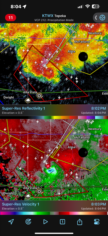
-
2024 Short/Medium Range Severe Weather Discussion
SchaumburgStormer replied to Chicago Storm's topic in Lakes/Ohio Valley
Pretty awesome radar signature out in Kansas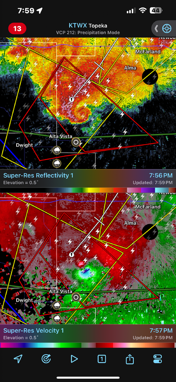
-
2024 Short/Medium Range Severe Weather Discussion
SchaumburgStormer replied to Chicago Storm's topic in Lakes/Ohio Valley
Yeah, seems for the good ones at this time of year we are tracking the front northwards waiting for it to get hung up along I-80, lol -
March 2024 General Discussion
SchaumburgStormer replied to MazooWeather's topic in Lakes/Ohio Valley
For sure. All it takes is a 2 week stretch of below normal precip and above normal temps and suddenly we are getting creeped on by the brown on the map