SchaumburgStormer
-
Posts
5,847 -
Joined
-
Last visited
Content Type
Profiles
Blogs
Forums
American Weather
Media Demo
Store
Gallery
Everything posted by SchaumburgStormer
-
Tons of lightning in the core. This thing will be strengthening through landfall.
-
The east side of this storm is going to be catastrophic for a lot of people. Unbelievable intensification we are seeing
-
Bombs away. Once those hot towers got wrapped around we are picking up in intensity quickly.
-
We’ve seen time and time again where we have sig pressure drops in between recon passes. Certainly can be a quick process.
-
Seems like we have been consistently surprised lately but intensity of RI. Wouldn’t shocked me to see this one go high end once we flush that dry air out and hit diurnal max
-
Forward speed and size of this thing is going to really surprise some folks far inland.
-
Yep, should be off to the races this evening. Minimal land interaction really has this one looking much better already than I thought it would a few days ago.
-

September 2024 General Discussion
SchaumburgStormer replied to Geoboy645's topic in Lakes/Ohio Valley
Looks like a good soaker incoming this morning. 2" on the month after being shut out for the first 3 weeks. -
September 2024 General Discussion
SchaumburgStormer replied to Geoboy645's topic in Lakes/Ohio Valley
got .44" of much needed rain overnight. Wont put a dent in the drought, but nice to knock the dust down. -
September 2024 General Discussion
SchaumburgStormer replied to Geoboy645's topic in Lakes/Ohio Valley
Looks like windows open weather tomorrow through Monday. Love it. -
September 2024 General Discussion
SchaumburgStormer replied to Geoboy645's topic in Lakes/Ohio Valley
Better get them furnaces rolling.
-
Cooking - 94/83/120
- 231 replies
-
- 2
-

-

-
- absolute trainwreck?
- abandon all hope?
- (and 1 more)
-
Spring/Summer '24 Banter and Complaint Thread
SchaumburgStormer replied to IWXwx's topic in Lakes/Ohio Valley
Tough for me to complain about a summer that has been dominated by mid-70's to low-80's -
Getting pretty crunchy out here. Hoping for a soaker tomorrow.
-
July 2024 General Discussion
SchaumburgStormer replied to Chicago Storm's topic in Lakes/Ohio Valley
Miss south stank. -
July 2024 General Discussion
SchaumburgStormer replied to Chicago Storm's topic in Lakes/Ohio Valley
Someone in that area is probably at like 15”+ MTD -
July 2024 General Discussion
SchaumburgStormer replied to Chicago Storm's topic in Lakes/Ohio Valley
Swing and a miss with all the pop up showers the last couple days -
2024 Short/Medium Range Severe Weather Discussion
SchaumburgStormer replied to Chicago Storm's topic in Lakes/Ohio Valley
Seeing some social media videos of spin ups, and they appear to be sizable tornados. Not the wimpy QLCS stuff you see a lot. -
2024 Short/Medium Range Severe Weather Discussion
SchaumburgStormer replied to Chicago Storm's topic in Lakes/Ohio Valley
LOT had to shelter and hand off warnings. The backup office probably just said “fuck this shit” and drew the big boxes -
2024 Short/Medium Range Severe Weather Discussion
SchaumburgStormer replied to Chicago Storm's topic in Lakes/Ohio Valley
and a spinner further south. Going to be a mess for LOT trying to warn all these short spin ups over the metro
-
2024 Short/Medium Range Severe Weather Discussion
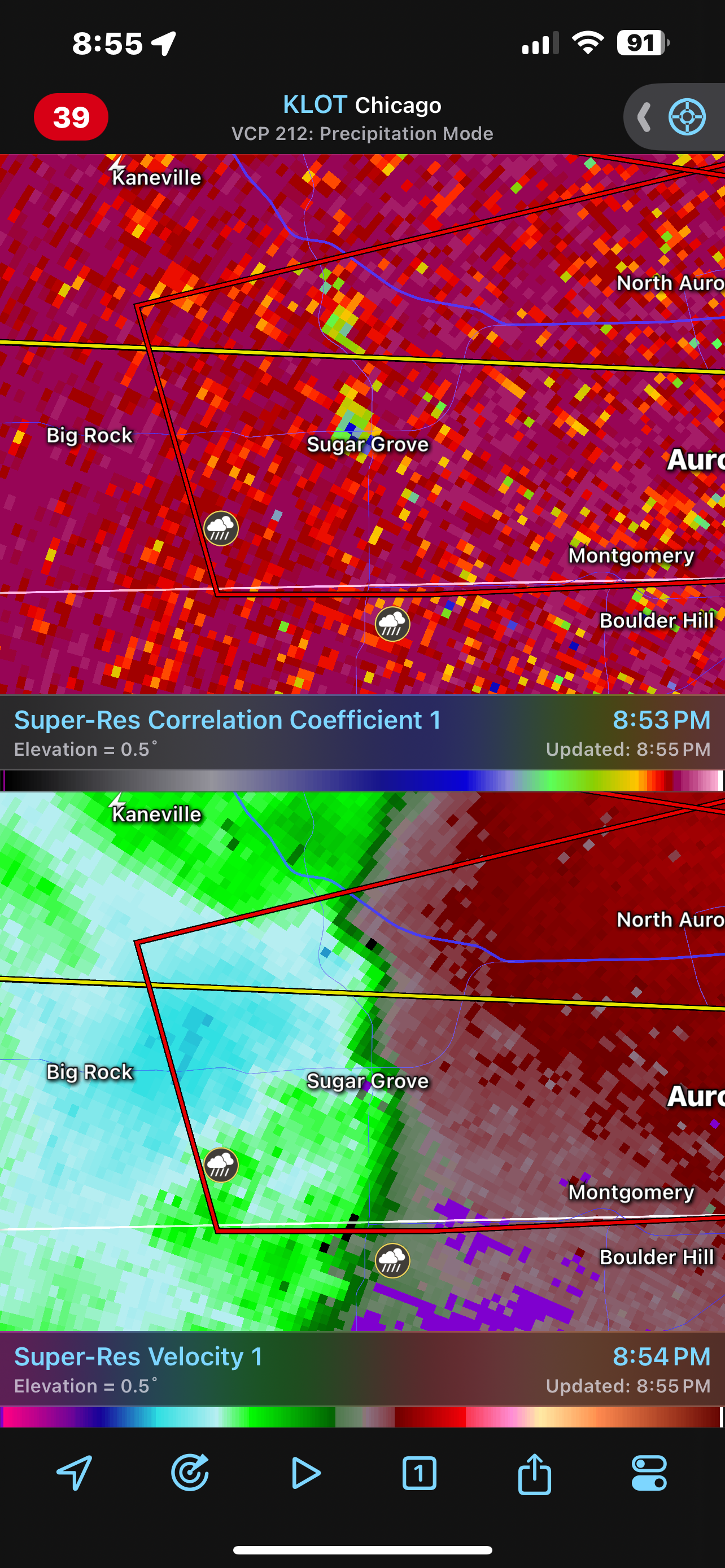
SchaumburgStormer replied to Chicago Storm's topic in Lakes/Ohio Valley
Yeah it’s persisted a few frames. Definitely got something in the little kink -
2024 Short/Medium Range Severe Weather Discussion
SchaumburgStormer replied to Chicago Storm's topic in Lakes/Ohio Valley
TOG? Or clutter?
-
2024 Short/Medium Range Severe Weather Discussion
SchaumburgStormer replied to Chicago Storm's topic in Lakes/Ohio Valley
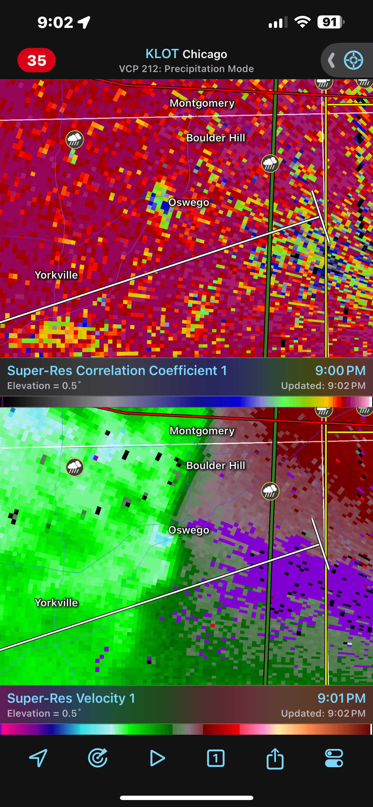
Maybe a brief cc drop north of maple park -
2024 Short/Medium Range Severe Weather Discussion
SchaumburgStormer replied to Chicago Storm's topic in Lakes/Ohio Valley
Lots of little kinks in the bow of that line. -
2024 Short/Medium Range Severe Weather Discussion
SchaumburgStormer replied to Chicago Storm's topic in Lakes/Ohio Valley
Got my back yard in its sights. Keeping the kids awake to head downstairs if it holds it’s intensity