

coastalplainsnowman
-
Posts
953 -
Joined
-
Last visited
Content Type
Profiles
Blogs
Forums
American Weather
Media Demo
Store
Gallery
Everything posted by coastalplainsnowman
-
Wikipedia says that the last time Mount Batur erupted was about the year 2000. Based on what I'm reading in this thread, sounds like the odds of it erupting again before we see measurable snowfall again at the coast are about 50/50.
-
Thanks for this - just to clarify - warmer than Richmond was for the same time periods, or warmer than Richmond's likewise historical averages?
-
For what it’s worth, growing up on LI in the 80s with family up there, seemingly every time we had an agonizingly close snowstorm which was instead a cold rain storm, they would get plastered with snow, so often that it was the running joke.
-
He posted one 440,000,000,000 times? Crazy if true. I think that people who have a nostalgic love of snow and follow things on this board as hobbyists (present company included) are practically guaranteed to be unhappy if they set unrealistic expectations. - If you love snow, and you're a met, that's great because it's great to be enthusiastic about what you do for a living, or aspire to do for a living. - If you are someone who loves snow, but doesn't know about this board, then ignorance is bliss. If it's cold out, like it has been the last few days, you're loving it, not having much awareness about the fact that it will probably warm up and rain a little right on time for Christmas. You're living in the present and enjoying the evening. You're hopeful (and likely correct regardless of everything discussed here), that you'll get at least one or two grass-covering snows that will slow life down a bit this winter, and you look forward to it. BUT, if you love snow, are not a met, and follow here to learn and to get the inside scoop, then you're rarely happy if you let yourself set your expectations too high. Sure, it's been crisp and cold the last few days, but we're bummed because we know it'll be warm soon. When it snows, we know with specificity when it's going to get washed or melted away, rather than being able to dream that winter wonderland will last for awhile. And while it is actually snowing, we watch the radar instead of the actual snow - the thing we waited for for months - aggravated that the very best bands aren't on top of us, and watching the western edge speeding eastbound from PA. Or, we watch the rain/snow line inching closer, and make sure we spoil the fun of those around you by letting them know.
-
Thanks for these posts - these are great. I read them every time I'm on here, and kind of take them for granted, just like I do for a lot of the great stuff that you, Don, and others post daily. ( I'm sure I'm not the only one guilty of this.) Thanks for all the time you put into these.
-
I guess I should do the same analysis now from whatever town you arrived from and see if there's been an opposite effect on temperature there.
-
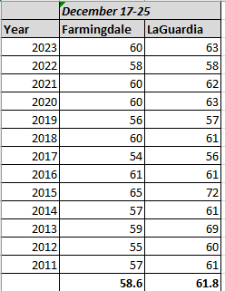
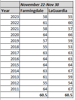
Right on schedule, our annual holiday mood crushing 60 degree day within a week of Christmas. Here's what I think happened: Somebody here sold their soul to you-know-who, Joe Namath style, in exchange for the December 26/27 2010 Blizzard, because since then, here's the high temperature reached at Farmingdale and LaGuardia, the week leading up to Christmas, for each year since. Based on the 13 years since, Farmingdale on average hits 58.6 degrees, and LaGuardia reaches 61.8. Edit: Did the same for Thanksgiving week, defined as Nov. 22-Nov 30th. Farmingdale for the Thanksgiving period averages just 2 degrees higher; LaGuardia has an outright lower maximum temp over the Thanksgiving timeframe than the Christmas week timeframe. (The averages are coincidentally the same for both sites for the Thanksgiving timeframe.)
-
Moderate-High Impact Storm Noon Sun Dec 17, 2023 - 4PM Mon Dec 18. Flooding rain I95 corridor northwestward, coastal tidal flooding, brief periods of damaging 50 MPH+ wind gusts LI/CT Monday, ends as a little wet snow interior elevations Tue morning.
coastalplainsnowman replied to wdrag's topic in New York City Metro
If only you had put an 's' in that sad empty space between 'thunder' and 'now.' When I first read it, my mind tried so hard to imagine it there.- 489 replies
-
- 2
-

-

-
- flooding rains
- coastal flooding
- (and 4 more)
-
Moderate-High Impact Storm Noon Sun Dec 17, 2023 - 4PM Mon Dec 18. Flooding rain I95 corridor northwestward, coastal tidal flooding, brief periods of damaging 50 MPH+ wind gusts LI/CT Monday, ends as a little wet snow interior elevations Tue morning.
coastalplainsnowman replied to wdrag's topic in New York City Metro
The funny part is that reading about 2-4, 3-6, up to as much as 7, on December 17th, if I just stumbled in here I would be sure we were talking about snow totals. Looks like we're going to be thisclose to getting our new obligatory, irritating, annual Christmas week 60 degree reading tomorrow. -
There are some serious first world problems going on in here. What's so terrible? Replies we disagree with, feel aren't logically sound, or are written just to get a rise out of people? Or worst of all, God forbid, there's a tiny picture of a hotdog being applied to a post we like? Does it really need to be said that you can ignore posters you find irritating anytime you like? And just don't look at the emojis if that's too rough. I blame the lack of snow on all of this, dammit. Contrast with when a big storm, predicted for days, is finally bearing down on the area. That's when this place is awesome, when the whole 'I love you man!' vibe pervades. You know, when you get people saying stuff like 'I'm getting shut out, but you guys in location X enjoy it! I love you man!" It's the comical polar opposite of what we're seeing right now. Just one real storm threat, that's all we need, like a Christmas miracle.
-
Still holding on strong in Nassau. As a kid, Bethpage Park was awesome for sledding. Last time I was there about ten years ago it was still permitted, but restricted to certain roped off areas. Pleasantly surprising that it even still happens considering that the complex hosts majors and soon a Ryder Cup (last time I was there the sledding was between the Black and Green courses.) The backlash would probably be too much if they stopped it.
-
Thanks as always Don. While the general point being made here and elsewhere about the rarity of snowfall immediately following a 60 degree December day makes sense, I was struck in a different way by this data: I was surprised to see that there's such a population of 60 degree December days going back to the late 1880s that we actually have a subset of five such days followed by snow to even talk about. Prior to the crazy run of 60 degree days popping up in mid December for most of the past 12-15 years, I'd only remembered one such warm day in the 80s, and always assumed 60 degrees in December to be exceedingly rare prior to that point, but that doesn't seem to be the case.
-
Thanks anyway. Taking a shower with no hot water or electricity after a July T storm is one thing. Doing the same for three days with cold water when the house is around 50 is another story. Still haven’t gotten the chill out of me.
-
2002 was great - no doubt - never seen rain go over to snow and accumulate on *everything* like that did However, 1983 takes the cake for me. Granted, just enough snow to cover the grass and street, but check out the high temperatures from that day. Christmas Eve's high temp was just past midnight in the 20s. Fell through the day down to 5 on Christmas Eve night, and didn't get out of the mid teens on Christmas. Awesome. One year prior we were outside in short sleeves on Christmas Eve 1982..
-
One other point about the whole snow in December discussion. For all the good reasons given here, there's also the whole thing about *where we live.* For anyone on here who's not still in school/college, especially nearish to the coast: growing up how many snow days did you have in your lifetime in December?
-
On the bright side, the biggest daily total later that winter, other than 1966, which I couldn't find, is as follows. Statistically speaking, it seems that the last two months of meteorlogical winter for these winters are, at worst, no worse than average in terms of still seeing a big snowfall. Maybe even better than average odds? I'd be ok with the 2016 result lol. 1973: 1.8 1983: 12.5 (seems low) 1987: 8.1" 1998: 5.0" 2016: 27.3
-
We have to have at least one 60 degree day the week leading up to Christmas, so everything was bound to align for that eventually.
-
Last year I wanted to try to prove this out, i.e. what the standard deviation looked like since 1995 as compared to the previous similar timeframe, but I never did it. To the eye it definitely looks like the size of the standard deviation has increased significantly.
-
100%. That timeframe saw 50"+ snowfall *more often than not* even on Long Island. Anyone growing up during that is bound to be disappointed. Compare it to a kid of the 80s. Even after 2000-2018 I'm still happy with anything that covers the grass.
-
In fairness, the Jets could play all their home games at Atacama Desert Stadium and they would still always be sloppy.
-
Reading this I was thinking about how if from ages 5-25 I experienced roughly a dozen winters of 50" + snowfall, on Long Island no less, what my snowfall expectations would be like with that as a frame of reference. It would be impossible for them not to be sky high.
-
Regarding this part: "There were always warm years here and there, less snowy and more snowy winters. But both the magnitude of and frequency of warmth right now appears unprecedented. At least from temperature data I’ve reviewed. I do find that upsetting. Not much I or anyone can do about it, but it sucks." I look at it this way - In the worst case scenarios, NYC metro's weather in 25-30 years will be similar to what, current northern VA? If you grew up there in the 80s/90s, you still had some historical and memorable snowstorms and cold. You wouldn't have thrown in the towel, right? The snow and storms wouldn't come quite as often as here - maybe - since there are so many other factors as we know - but they'd still happen. Same situation here. It's not like we live in the Arctic, and I think the 2001-2019 set our expectations way higher than they should be. If temperatures continue to rise like they have been, regarding historic snows, it's like our odds of winning $500 on a lottery ticket dropped from 1 in 500 to 1 in 1,500. At the coast at least, it's always been a longshot, with enough other factors at play that the total amount of winters we're around and able to appreciate it are barely sufficient for a good sample size.
-
Does it bother anyone else that they can't bother to put a color on geographic Long Island? I mean, only about 8 million people live here. If they did the same to Idaho, Montana, Wyoming, North Dakota, South Dakota and Nebraska combined, I bet a lot of folks would rightly complain that the map isn't anywhere near complete, yet those states total about two thirds of the population of Long Island. Also, get off my lawn!
-
On the Nassau south shore that snow hung on til about 3:30 or so. I remember looking out the window at school, already cursed with enough meteorology knowledge to know that rain was on the doorstep, and so was unable to share in the joy of my bilssfully innocent classmates, yet shocked at this storm which was breaking the 'inevitable changeover to rain' axiom that I'd come to just concede as a fact of life. Will never forget shoveling my driveway after school in what had by then in fact finally become rain. It was without a doubt the most waterlogged, brutally heavy snow to shovel that I've ever experienced.
-
Also, the bitter, *bitter* miss in 1989 - either February or March. Almost the opposite of '83 in terms of expectation vs result. Left for school expecting a heavy snow to start mid day. Ended up with Not. A. Flake. It was the type of storm which today would have caused schools and businesses to close premptively. If memory serves, Atlantic City got 18" and Montauk got 12". That one left me convinced that an '83-like storm was never ever going to happen again. What a fitting way to end the 80s.

