-
Posts
23,912 -
Joined
Content Type
Profiles
Blogs
Forums
American Weather
Media Demo
Store
Gallery
Everything posted by donsutherland1
-

Occasional Thoughts on Climate Change
donsutherland1 replied to donsutherland1's topic in Climate Change
That's not the issue. His inaccurate claims concerning Phoenix in 1879 is the issue. -

Occasional Thoughts on Climate Change
donsutherland1 replied to donsutherland1's topic in Climate Change
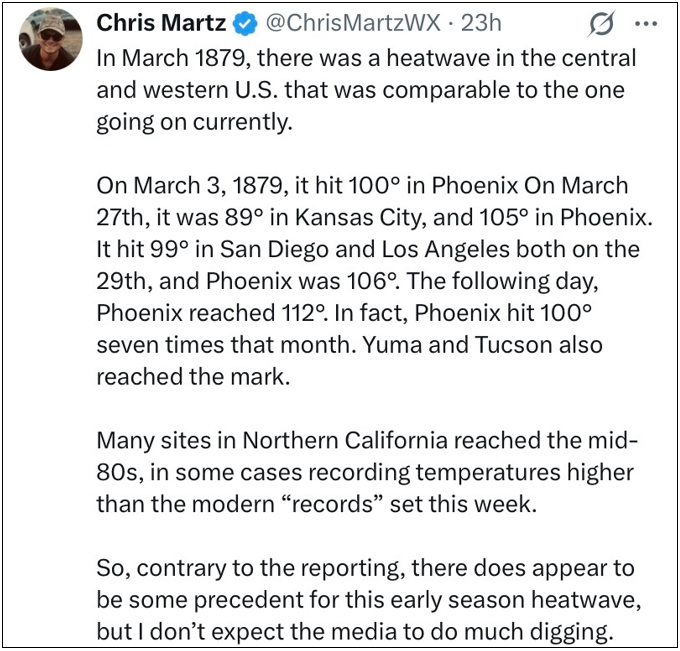
He's not a practicing meteorologist. He works for an organization that largely rejects AGW. Regardless of his position and employer, he should post accurate data. It's difficult to know why he would post information regarding Phoenix that is so obviously wrong (112° in March, 100° on March 3, and 7 100° days in March during 1879), especially as Phoenix is a high-profile city and, by its nature, has resources that can be found through research. -

Occasional Thoughts on Climate Change
donsutherland1 replied to donsutherland1's topic in Climate Change
No. He blocked me when I corrected him in the past for misrepresenting data and provided links to the actual data. I did post the correct MWR data on Twitter/X in a thread in which he's copied. -

Occasional Thoughts on Climate Change
donsutherland1 replied to donsutherland1's topic in Climate Change
Yes. that's correct regarding San Diego and Los Angeles. That's why I referred to it as a "localized heat event in southern California." Some heat came eastward into a portion of Arizona (Yuma's 100° reading), but this wasn't the kind of widespread heatwave like the ongoing on. It was nowhere near as intense as the ongoing one. Unfortunately, the maps have a a nine-hour gap between observations and there isn't a larger set of observations. I suspect that the offshore winds winds seen north of Los Angeles at the 4:35 am PDT observation sank south after that observation. The wind then turned onshore shortly before the 1:35 pm PDT observation, as the temperature was still 97° in the Los Angeles area. -

Occasional Thoughts on Climate Change
donsutherland1 replied to donsutherland1's topic in Climate Change
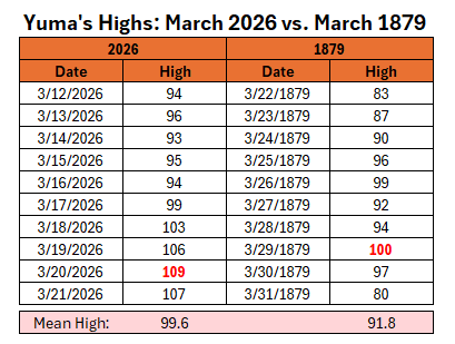
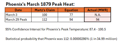
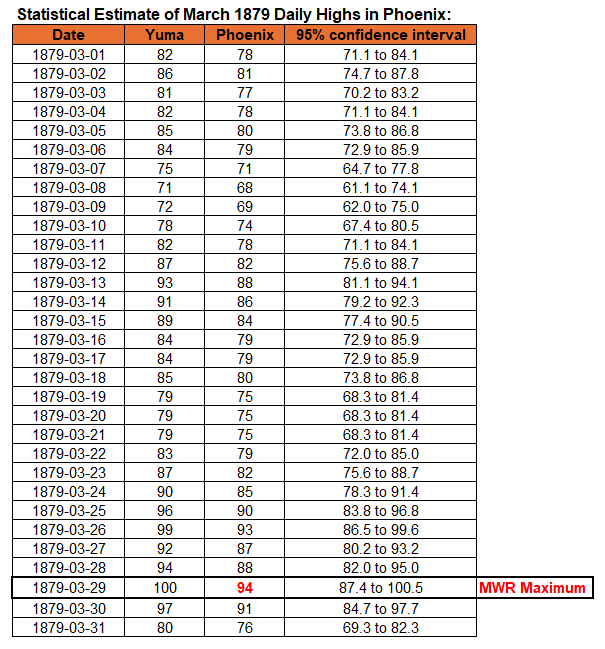
As was the case last year when Phoenix reached an August monthly record high of 118°, an ignorant handful are attempting to dismiss the magnitude of the ongoing unprecedented March heatwave. In this case, the effort is to transform what was very likely a localized heat event in southern California due to possible offshore winds into an epic regionwide heat event that surpassed the ongoing heat event that has toppled March and April records in many locations in the West. The above post also applies projection, accusing the news media, of not doing "much digging." In fact, the post demonstrates dismal research skills. The question concerns whether Phoenix ever reached 112° in March during 1879. That heatwave was likely referenced, because Phoenix's daily records go back to August 1895. Thus, the underlying assumption was that one could not credibly question the claim. That's not true. Several approaches apply. 1) Is there any credible data for Phoenix from March 1879? Yes. Monthly Weather Review published monthly maximum and minimum temperatures for select locations. Below is the Monthly Weather Review report for March 1879. I highlighted Phoenix and Tucson, as one can make a comparison to the current heatwave. The monthly high temperatures for Phoenix and Tucson during the current heatwave are 105° and 102° respectively, vs. the 94° and 90° in March 1879. 2) If there were no credible data (not the case here), are there any reliable records from this period in the relevant area? Yes. Yuma's climate record goes back to January 1878. Yuma's monthly maximum temperature for March 1879 was 100° on March 29, 1879. Yuma's highs are typically above those of Phoenix. For example in the current heatwave, Yuma had a peak high of 109° vs. Phoenix's 105°. One could also construct a regression equation to estimate Phoenix's high based on Yuma's data. Since one is dealing with pre-urban Phoenix, I chose the earliest 30-year period of each site's overlapping record (March 1896-March 1935). The regression equation was (0.908 *Yuma's Maximum) +3.152. The standard error was 3.33°. The coefficient of determination was 0.833. So, what happens when one calculates the estimated highs for Phoenix based on the Yuma's March 3 high of 81° and its March 29 high of 100°. The end result is an expected high of 77° (76.7°) on March 3 and a high of 94° (94.0°) on March 29. The statistical data reveal that there was virtually no chance that Phoenix was 112° during March 1879. In fact, the statistical data matches the actual monthly high. Major Findings: Note: Actual data is the Monthly Weather Review monthly maximum temperatures for Phoenix and Tucson and daily data from Yuma's climate record. What happened? More than likely Martz was using data from a thermometer that was exposed to direct sunshine. Amateurs accept such data at face value. They have little understanding of issues that could compromise the data or little understanding about conducting research. Those with motivated reasoning embrace such data when it confirms their biases. Researchers ask questions concerning whether reliable data exists for the specific location, whether reliable data exists for nearby locations, etc. If reliable data is present for nearby locations, but not the specific location, they construct models based on the relationship of those nearby locations and the specific location in question. Afterward, they run those models and make estimates. I used statistical modeling just to illustrate how such models can be quite accurate. There was actual data (Monthly Weather Review). Overall Conclusion: The March 2026 heatwave is the most severe heatwave Phoenix has experienced in the period where records exist (even prior to the daily period of record that begins in August 1895) during March. There has been no remotely comparable past March heat event to the ongoing one affecting Phoenix and the Southwest. -

Occasional Thoughts on Climate Change
donsutherland1 replied to donsutherland1's topic in Climate Change
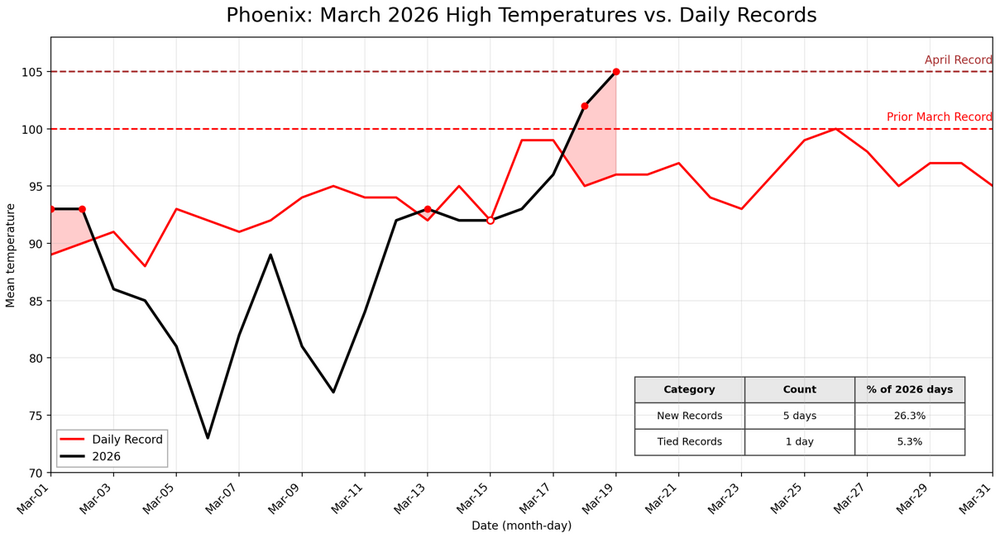
The previous earliest 3 consecutive day stretch of 105 days was May 2-4, 1947. -
The temperature will rise into the lower to perhaps middle 60s during on Sunday. A few showers and thundershowers are likely late tomorrow into early Monday. A somewhat cooler air mass will likely arrive early next week. Monday and Tuesday will see temperatures topping out in the upper 40s to near 50° in New York City. Readings will return to the lower and perhaps middle 50s by midweek. The ENSO Region 1+2 anomaly was +1.5°C and the Region 3.4 anomaly was 0.0°C for the week centered around March 11. For the past six weeks, the ENSO Region 1+2 anomaly has averaged +0.98°C and the ENSO Region 3.4 anomaly has averaged -0.15°C. Neutral ENSO conditions will continue through at least mid-spring. The SOI was -1.25 today. The preliminary Arctic Oscillation (AO) was +2.149 today. Based on sensitivity analysis applied to the latest guidance, there is an implied 87% probability that New York City will have a warmer than normal March (1991-2020 normal). March will likely finish with a mean temperature near 44.9° (2.1° above normal). Supplemental Information: The projected mean would be 2.4° above the 1981-2010 normal monthly value.
-

Occasional Thoughts on Climate Change
donsutherland1 replied to donsutherland1's topic in Climate Change
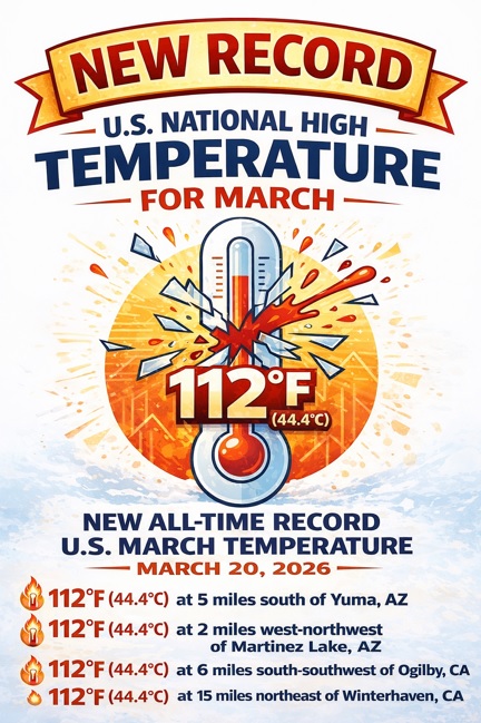
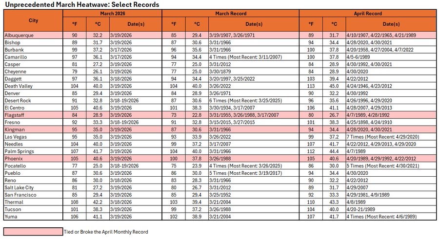
Today was the most brutal day during the ongoing epic heatwave in the West. A new U.S. national temperature record for March was set at four locations. -
The temperature will rise to the middle and upper 50s tomorrow and lower to perhaps middle 60s during on Sunday. A few showers are possible on tomorrow. A somewhat cooler air mass will likely arrive early next week. The major weather story this week is the ongoing super March heatwave in much of the western U.S. March monthly records are being set in numerous cities. The ENSO Region 1+2 anomaly was +1.5°C and the Region 3.4 anomaly was 0.0°C for the week centered around March 11. For the past six weeks, the ENSO Region 1+2 anomaly has averaged +0.98°C and the ENSO Region 3.4 anomaly has averaged -0.15°C. Neutral ENSO conditions will continue through at least mid-spring. The SOI was -3.83 today. The preliminary Arctic Oscillation (AO) was +2.345 today. Based on sensitivity analysis applied to the latest guidance, there is an implied 79% probability that New York City will have a warmer than normal March (1991-2020 normal). March will likely finish with a mean temperature near 44.6° (1.8° above normal). Supplemental Information: The projected mean would be 2.1° above the 1981-2010 normal monthly value.
-
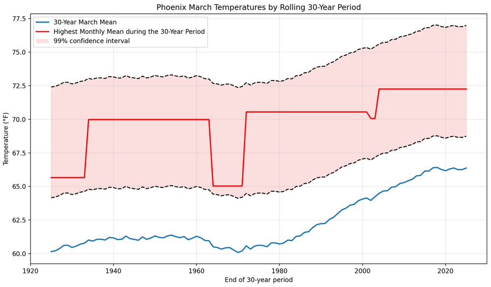
Although the flash analysis isn't peer reviewed, it is derived from a peer-reviewed methodology, which provides credibility. These studies provide value, as they provide an alternative to pure statistical research. The corroboration between the modeling and statistics enhances the quality of their findings. Further, studies concerning prior extreme heat outbreaks in the Southwest have all found a strong link to climate change. As for March 2026, March 2026 is poised to become Phoenix's first March to break outside the 99% confidence interval based on 30-year climate data.
-
World Weather Attribution's flash analysis of the unprecedented March heat in western North America. Excerpt: Observation-based data products show a strong increase in the likelihood and intensity of heat waves in the region, suggesting that such events have become about 4°C warmer as a best estimate, and that events as warm as in March 2026 would have been virtually impossible without human-induced climate change. Climate models strongly underestimate this observed trend but still show a significant increase in extreme heat. We combine models and observations, giving equal weight to both lines of evidence, and find an estimated increase in intensity of 2.6°C for such events, with an increase in likelihood of a factor of about 800. This means that without climate change it would have been virtually impossible for the event to occur.
-

Occasional Thoughts on Climate Change
donsutherland1 replied to donsutherland1's topic in Climate Change
That statement about a near zero impact is wrong. The impact is smaller but not near zero. Water vapor saturation does not mean that additional CO2 won't have an impact. Water vapor has a maximum impact in the lower atmosphere. The upper atmosphere is drier. Increased CO2 reduces outgoing longwave radiation, leading to additional warming. -
The temperature will return to the middle 40s tomorrow afternoon. Readings will then return to the 50s for Friday and then the upper 50s and lower 60s during the weekend. A few showers are possible on Saturday. A somewhat cooler air mass will likely arrive early next week. The major weather story this week is the super March heatwave that is under way in much of the western U.S. March monthly records are being set in numerous cities. Today, Albuquerque, Flagstaff, Palm Springs, Phoenix, and Tucson are among the cities setting March monthly records. Additional records are likely in coming days. The ENSO Region 1+2 anomaly was +1.5°C and the Region 3.4 anomaly was 0.0°C for the week centered around March 11. For the past six weeks, the ENSO Region 1+2 anomaly has averaged +0.98°C and the ENSO Region 3.4 anomaly has averaged -0.15°C. Neutral ENSO conditions will continue through at least mid-spring. The SOI was +0.43 today. The preliminary Arctic Oscillation (AO) was +2.006 today. Based on sensitivity analysis applied to the latest guidance, there is an implied 76% probability that New York City will have a warmer than normal March (1991-2020 normal). March will likely finish with a mean temperature near 44.6° (1.8° above normal). Supplemental Information: The projected mean would be 2.1° above the 1981-2010 normal monthly value.
-
It will begin to turn milder tomorrow. The temperature will return to the middle 40s tomorrow afternoon. Readings will then return mainly to the 50s for Friday through the weekend. The mercury could reach 60° on Saturday. The major weather story this week is the super March heatwave that is under way in much of the western U.S. March monthly records are being set in numerous cities. Today, Flagstaff, Palm Springs, and Phoenix are among the cities setting March monthly records. Additional records are likely in coming days. The ENSO Region 1+2 anomaly was +1.5°C and the Region 3.4 anomaly was 0.0°C for the week centered around March 11. For the past six weeks, the ENSO Region 1+2 anomaly has averaged +0.98°C and the ENSO Region 3.4 anomaly has averaged -0.15°C. Neutral ENSO conditions will continue through at least mid-spring. The SOI was +3.73 today. The preliminary Arctic Oscillation (AO) was +0.539 today. Based on sensitivity analysis applied to the latest guidance, there is an implied 74% probability that New York City will have a warmer than normal March (1991-2020 normal). March will likely finish with a mean temperature near 44.7° (1.9° above normal). Supplemental Information: The projected mean would be 2.2° above the 1981-2010 normal monthly value.
-

Occasional Thoughts on Climate Change
donsutherland1 replied to donsutherland1's topic in Climate Change
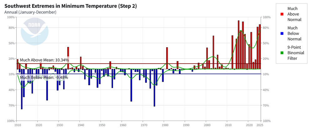
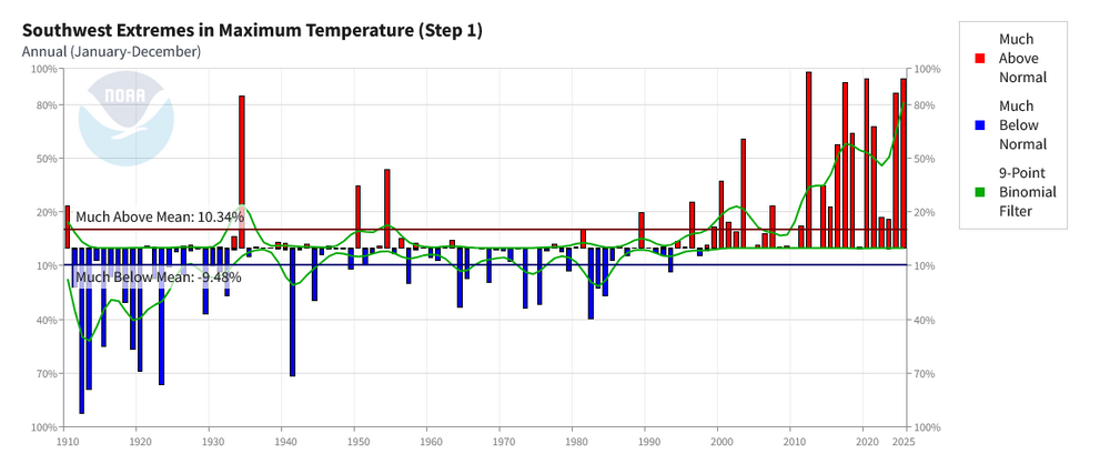
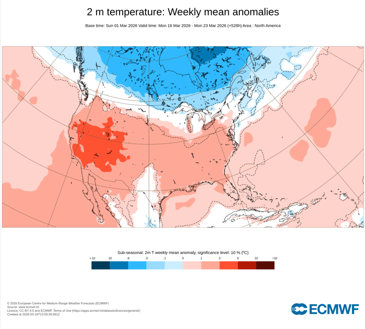
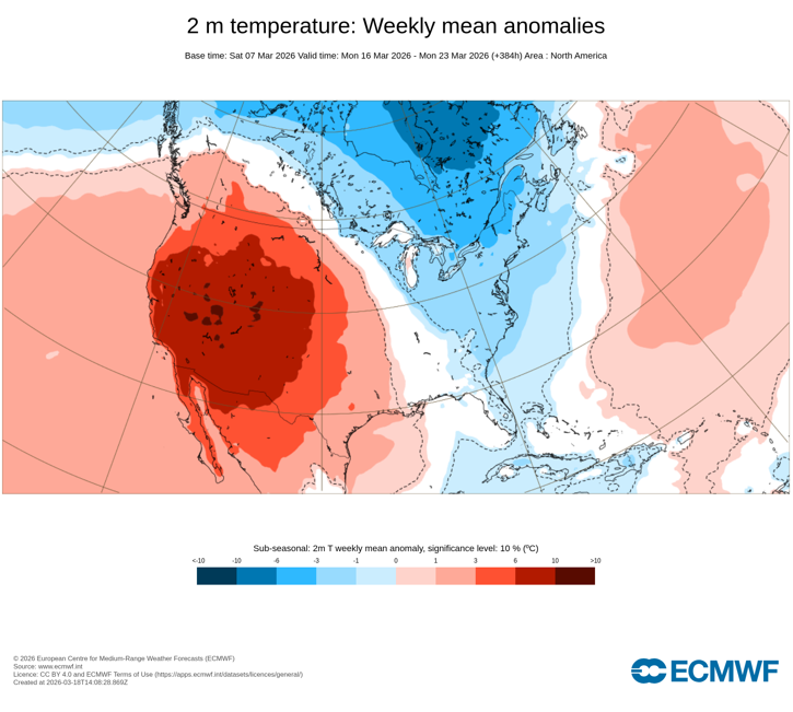
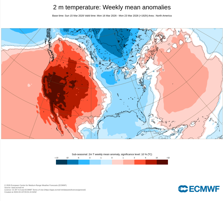
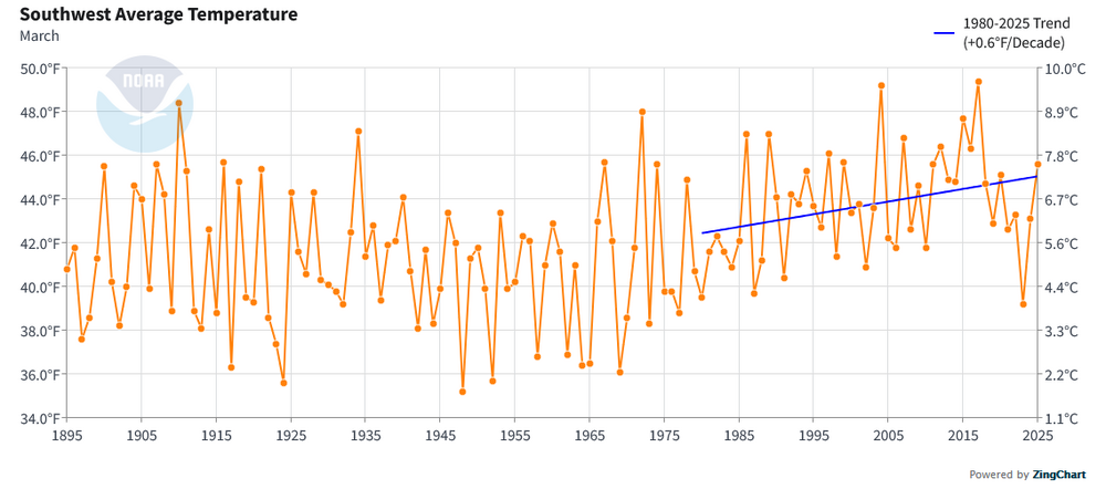
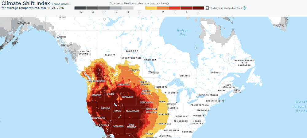
The long-advertised historic March heatwave is now gathering force in the Southwest. Already, monthly high temperature records have fallen in Burbank, Camarillo, and Thermal. Monthly marks were tied in Flagstaff and San Francisco. Downtown Los Angeles missed its longstanding monthly record from 1879 by 1°. Although Palm Springs missed its monthly record by 1° yesterday, it demolished its monthly warmest minimum temperature record by 5° with a low of 75° (a level not seen previously until April 21st). Following the conclusion of a winter that was the warmest on record for many parts of the region, the signature for a possible heat event appeared far in advance. ECMWF Weeklies: March 1: The guidance remained persistence and moved toward an extreme event as the lead time shortened. ECMWF Weeklies: March 7: The final ECMWF weekly forecast from March 15 showed a record-breaking event was imminent. ECMWF Weeklies: March 15: Despite the attention high-profile urban areas receive, the entire region has been warming. Southwest (1980-2025): Warming can produce a non-linear increase in the frequency and severity of heat events, including outside of summer. The March 2012 and September-October 2024 heat events are examples. Climate Central has estimated that climate change has made the forecast event for the Southwest/West at least 5 times more likely in much of those regions. One can expect an avalanche of monthly records over the coming days. Some records could reach or exceed April monthly marks. -
Colder air has returned to the region. After a low in the upper 20s tomorrow morning, New York City will see a high near or just below 40°. Thursday will see the temperature return to the middle 40s. Readings will then return to the 50s for Friday through the weekend. The major weather story this week will be the super March heatwave that is now developing in much of the western U.S. March monthly records are likely to be smashed in numerous cities, including Albuquerque, Flagstaff, Fresno, Las Vegas, Palm Springs, Phoenix, Reno, Salt Lake City, and Yuma. Already, Camarillo, CA reached a March record 96° today. The ENSO Region 1+2 anomaly was +1.5°C and the Region 3.4 anomaly was 0.0°C for the week centered around March 11. For the past six weeks, the ENSO Region 1+2 anomaly has averaged +0.98°C and the ENSO Region 3.4 anomaly has averaged -0.15°C. Neutral ENSO conditions will continue through at least mid-spring. The SOI was +1.87 today. The preliminary Arctic Oscillation (AO) was +0.492 today. Based on sensitivity analysis applied to the latest guidance, there is an implied 84% probability that New York City will have a warmer than normal March (1991-2020 normal). March will likely finish with a mean temperature near 45.1° (2.3° above normal). Supplemental Information: The projected mean would be 2.6° above the 1981-2010 normal monthly value.
-
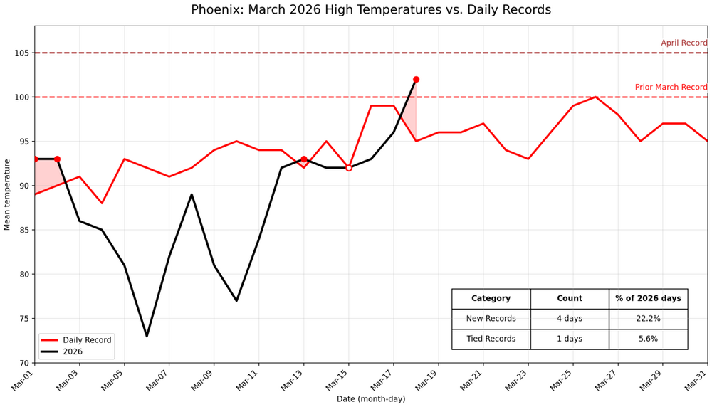
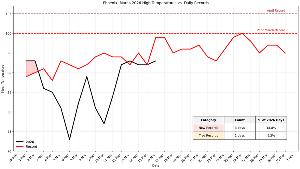
The unprecedented March heatwave is starting to build in the Phoenix area. As a result, March 2026 will very likely surpass the existing monthly mark by the largest margin on record for Phoenix. Through March 16th, Phoenix has a mean temperature of 73.3°. The prior March 1-16 record was 72.3° in 1972. So far, 25% of days have either tied or set daily records. So, even without the upcoming historic heatwave, March was running exceptionally warm.
-
I am very sorry to learn this sad news. He was a great member and good person.
-
Following this evening's rain and thunderstorms, a shot of much cooler air will arrive for tomorrow. Lows in New York City could fall to the middle and upper 20s with highs in the upper 30s and lower 40s tomorrow and Wednesday However, with the AO likely to remain generally positive through around March 20th, the cool period likely won't be as prolonged as had been the case during this past winter's cold regimes. Temperatures should return to the middle and upper 40s by Thursday and the 50s to end the week. Uncertainty about the closing 7-10 days of March has increased. The major weather story this week will be the super March heatwave that will develop in much of the western U.S. March monthly records are likely to be smashed in numerous cities, including Albuquerque, Flagstaff, Fresno, Las Vegas, Palm Springs, Phoenix, Reno, Salt Lake City, and Yuma. The ENSO Region 1+2 anomaly was +1.5°C and the Region 3.4 anomaly was 0.0°C for the week centered around March 11. For the past six weeks, the ENSO Region 1+2 anomaly has averaged +0.98°C and the ENSO Region 3.4 anomaly has averaged -0.15°C. Neutral ENSO conditions will continue through at least mid-spring. The SOI was -4.88 today. The preliminary Arctic Oscillation (AO) was +0.744 today. Based on sensitivity analysis applied to the latest guidance, there is an implied 72% probability that New York City will have a warmer than normal March (1991-2020 normal). March will likely finish with a mean temperature near 44.6° (1.8° above normal). Supplemental Information: The projected mean would be 2.1° above the 1981-2010 normal monthly value.
-
@bluewavewas referring to the New York City region. Yes, the March 2012 heatwave, June 2021 PNW heatwave, April 1976 one (no longer as anomalous today due to the 2002 heatwave) are also benchmark heat events.
-
Yes. February 2018 is probably best comparison for this region. It's incredible that the Southwest/West is seeing such an extreme event so soon after the September-October 2024 heat during which Phoenix set or tied daily records on 21 consecutive days and easily set new September and October monthly records.


