donsutherland1
-
Posts
23,761 -
Joined
Content Type
Profiles
Blogs
Forums
American Weather
Media Demo
Store
Gallery
Everything posted by donsutherland1
-
From the Bronx:
-
2025-2026 ENSO
donsutherland1 replied to 40/70 Benchmark's topic in Weather Forecasting and Discussion
While I won't go overboard about December's prospects e.g., no 1983-type cold, an EPO-/WPO-/AO-/PNA- month wouldn't be the worst of outcomes. There should be opportunities for snowfall and at least some cold should periodically push into the East. I highly doubt we'll see a "torch" December.
-
Thunder in Larchmont, NY.
-
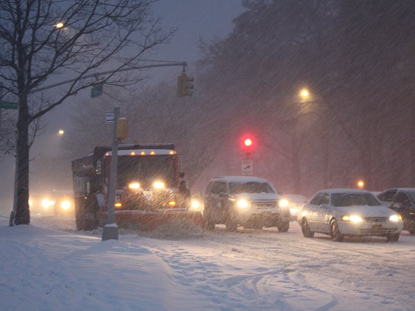
Tomorrow will turn briefly milder with highs generally reaching the lower and middle 50s before another cool air mass moves into the region. Some showers are possible with the frontal passage, but rainfall totals will generally be under 0.25" in most parts of the region. In the wake of the cold front's passage, a period of below normal temperatures will prevail through at least Wednesday and possibly Thursday. Highs will be mainly in themiddle and upper 40s in New York City with lows in the middle and upper 30s. A milder pattern could develop the latter part of next week. Some rain is possible. Meanwhile, today will be Central Park's 1,386th consecutive day without daily snowfall of 4" or more. The record of 1,394 days was set during February 22, 1929 through December 16, 1932. That stretch ended with 6.7" daily snowfall on December 17, 1932. The ENSO Region 1+2 anomaly was -0.2°C and the Region 3.4 anomaly was -0.7°C for the week centered around November 5. For the past six weeks, the ENSO Region 1+2 anomaly has averaged -0.07°C and the ENSO Region 3.4 anomaly has averaged -0.55°C. La Niña conditions will likely continue through at least mid-winter. The SOI was +6.42 today. The preliminary Arctic Oscillation (AO) was -1.018 today. Based on sensitivity analysis applied to the latest guidance, there is an implied 57% probability that New York City will have a cooler than normal November (1991-2020 normal). November will likely finish with a mean temperature near 47.4° (0.6° below normal). Supplemental Information: The projected mean would be 0.3° below the 1981-2010 normal monthly value.
-
2025-2026 ENSO
donsutherland1 replied to 40/70 Benchmark's topic in Weather Forecasting and Discussion
Griteater is very knowledgeable. It will be fasinating to see how things evolve. -
2025-2026 ENSO
donsutherland1 replied to 40/70 Benchmark's topic in Weather Forecasting and Discussion
Here's some data:
-
2025-2026 ENSO
donsutherland1 replied to 40/70 Benchmark's topic in Weather Forecasting and Discussion
I think we’ll get opportunities. I suspect winter will get off to a good start, as often happens with La Niña. -
2025-2026 ENSO
donsutherland1 replied to 40/70 Benchmark's topic in Weather Forecasting and Discussion
True. Fixed: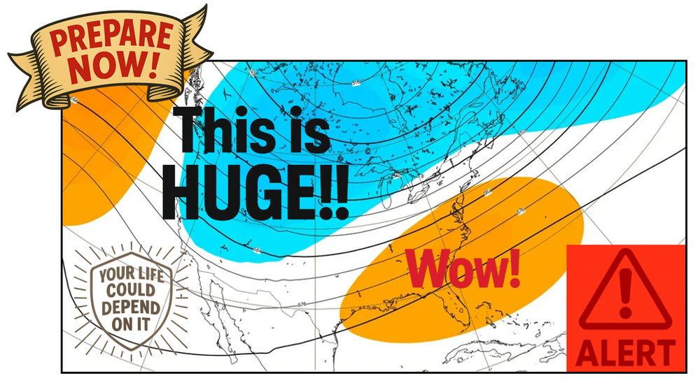
-
Occasional Thoughts on Climate Change
donsutherland1 replied to donsutherland1's topic in Climate Change
Low-cost labor is only a part of China's advantage in renewables. It probably helped initiate things, but China's advantage now goes far beyond labor costs. The combination of its comparative advantage in access to rare earth minerals, experience/learning benefits from aggressively advancing its renewable energy technologies, and economies of scale from its scaling production have given it a significant and sustainable competitive advantage. It's difficult to envision any other country being able to imitate what China is able to do in producing renewable energy technologies anytime soon. Moreover, China is beginning to deploy AI in its renewable energy technology development, which could give it another boost in its renewable energy leadership. In contrast, the U.S. has largely ceded this field. Moreover, its doubling down on energy of the past and its suppression of scientific research through policy/funding changes could essentially deprive it of a capacity to become competitive in renewable energy technology. -
2025-2026 ENSO
donsutherland1 replied to 40/70 Benchmark's topic in Weather Forecasting and Discussion
Social media version of the ECMWF weekly forecast for December 1-8:
-
2025-2026 ENSO
donsutherland1 replied to 40/70 Benchmark's topic in Weather Forecasting and Discussion
Below are the four major clusters for the EPO-/WPO-/PNA-/AO- (91% of all cases): Currently, the guidance favors the most common cluster.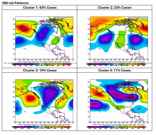
-
2025-2026 ENSO
donsutherland1 replied to 40/70 Benchmark's topic in Weather Forecasting and Discussion
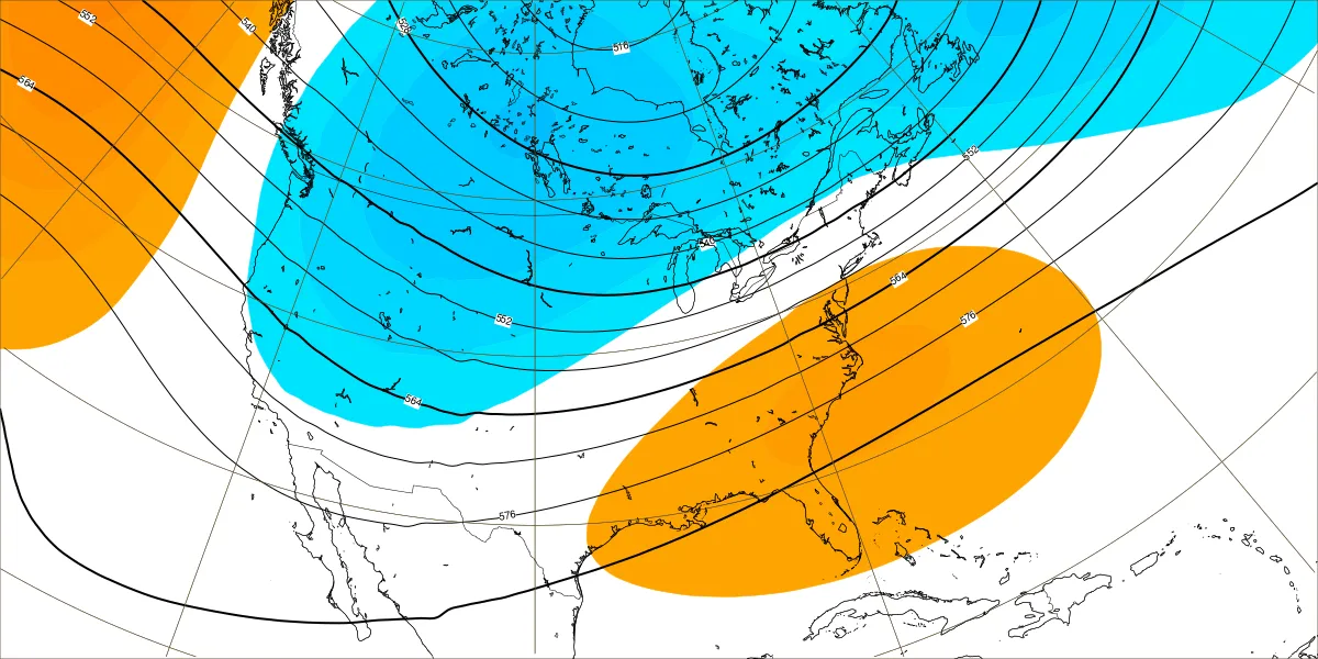
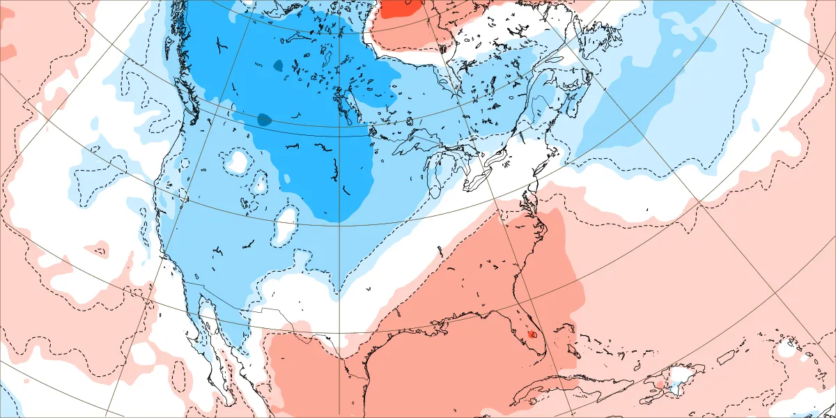
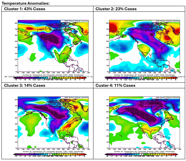
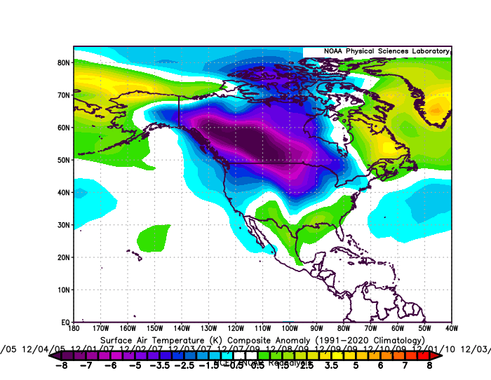
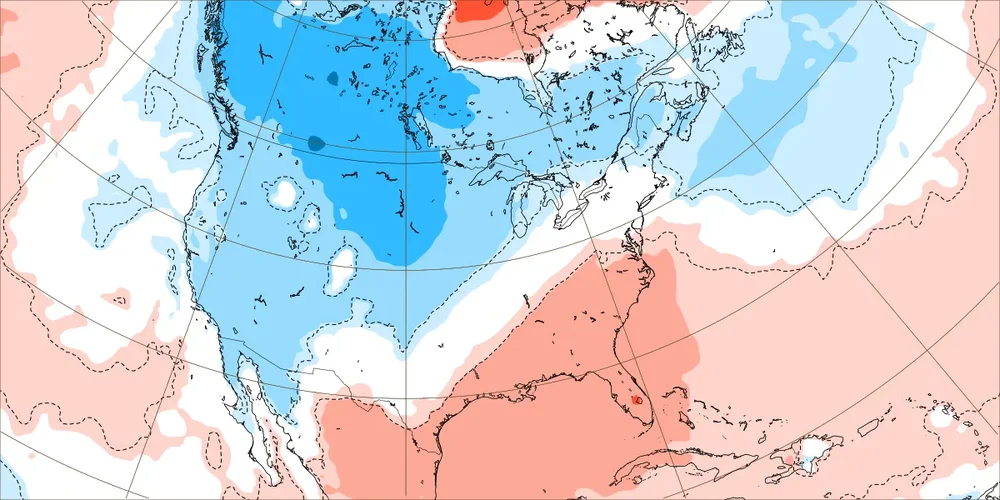
The EPS and long-range ECMWF continue to suggest that an EPO-/WPO-/PNA-/AO- pattern will develop to open December. Such a pattern typically favors a trough's being anchored in the West and extending mainly across Canada. Although some cold could periodically push into the eastern U.S., the coldest anomalies would stay in the west (both in Canada and the U.S.). December 1-10, 1980-2024: Composite 500 mb Anomalies: Composite Temperature Anomalies: December 1-8, 2025 ECMWF Weekly Forecasts: 500 mb Anomalies: Temperature anomalies: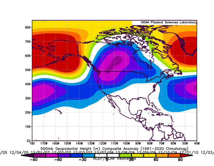

-
2025-2026 ENSO
donsutherland1 replied to 40/70 Benchmark's topic in Weather Forecasting and Discussion
That's why one should use a series of runs, not any single run. Below is the latest December monthly forecast.
-
Tomorrow will see highs mainly in the upper 40s to lower 50s. Sunday could turn briefly milder before another cool air mass moves into the region. Some showers are possible on Sunday with the frontal passage, but rainfall totals will generally be under 0.25" in most parts of the region. Temperatures will again top out mainly in the middle and upper 40s through the middle of next week. Meanwhile, today will be Central Park's 1,385th consecutive day without daily snowfall of 4" or more. The record of 1,394 days was set during February 22, 1929 through December 16, 1932. That stretch ended with 6.7" daily snowfall on December 17, 1932. The ENSO Region 1+2 anomaly was -0.2°C and the Region 3.4 anomaly was -0.7°C for the week centered around November 5. For the past six weeks, the ENSO Region 1+2 anomaly has averaged -0.07°C and the ENSO Region 3.4 anomaly has averaged -0.55°C. La Niña conditions will likely continue through at least mid-winter. The SOI was +5.21 today. The preliminary Arctic Oscillation (AO) was -1.534 today. Based on sensitivity analysis applied to the latest guidance, there is an implied 62% probability that New York City will have a cooler than normal November (1991-2020 normal). November will likely finish with a mean temperature near 47.2° (0.8° below normal). Supplemental Information: The projected mean would be 0.5° below the 1981-2010 normal monthly value.
-
I don’t believe one is a “doomer” to point out the risk of a long-term decline in seasonal snowfall. It won’t happen all at once. It will be long-term in nature. Even then, there will continue to be periodic snowy winters and occasional big snowstorms. Even a much warmer climate allows for such events. The historic Deep South snowstorm last winter is an example.
-
Snow events are synoptic and there is a lot of stochastic variability. Seasonal snowfall has a cyclical component and also a lot of stochastic variability. Long-term averages reflect climate. A warming climate has an impact, but NYC’s climate is far from a degree of warmth to largely or fully explain the ongoing snowfall slump. It has a marginal impact, but stochastic variability is primarily responsible.
-
2025-2026 ENSO
donsutherland1 replied to 40/70 Benchmark's topic in Weather Forecasting and Discussion
If one goes back to his September 7 video, he announces that El Niño is “rapidly fading.” There was no El Niño this year. All monthly Region 3.4 anomalies were negative (cool). If one doesn’t know the basics, that says a lot. But that’s the state of social media where hype suffocates quality. -
I agree. I don't see how the record won't be broken.
-
Tomorrow and Saturday will see highs mainly in the upper 40s to lower 50s. Overall, temperatures will likely remain generally below normal through Saturday. Sunday could turn briefly milder before another cool air mass moves into the region. Some showers are possible on Sunday with the frontal passage, but rainfall totals will generally be under 0.25" in most parts of the region. Temperatures will again top out mainly in the middle and upper 40s through the middle of next week. Meanwhile, today will be Central Park's 1,384th consecutive day without daily snowfall of 4" or more. The record of 1,394 days was set during February 22, 1929 through December 16, 1932. That stretch ended with 6.7" daily snowfall on December 17, 1932. The ENSO Region 1+2 anomaly was -0.2°C and the Region 3.4 anomaly was -0.7°C for the week centered around November 5. For the past six weeks, the ENSO Region 1+2 anomaly has averaged -0.07°C and the ENSO Region 3.4 anomaly has averaged -0.55°C. La Niña conditions will likely continue through at least mid-winter. The SOI was -3.25 today. The preliminary Arctic Oscillation (AO) was -1.651 today. Based on sensitivity analysis applied to the latest guidance, there is an implied 58% probability that New York City will have a cooler than normal November (1991-2020 normal). November will likely finish with a mean temperature near 47.4° (0.6° below normal). Supplemental Information: The projected mean would be 0.3° below the 1981-2010 normal monthly value.
-
2025-2026 ENSO
donsutherland1 replied to 40/70 Benchmark's topic in Weather Forecasting and Discussion
As things draw closer, even if the cold becomes less impressive, the following are plausible headlines from that account: “Get Ready: The Sudden Cold Blast That Will Shock Your Forecast!” “Temperatures Are About to Crash!” "The Temperature Plunge You Need to See to Believe.” As noted previously, social media is a veritable "Wild West" of meteorology information. There is no accountability. Clicks remain the single metric of value. Clickbait accounts are little more than the 21st century version of the 20th century's hawkers and hustlers. And, because these accounts deploy hyperbole to build enormous followings, it's no surprise that public perceptions of meteorology are distorted by the sensationalism. -
2025-2026 ENSO
donsutherland1 replied to 40/70 Benchmark's topic in Weather Forecasting and Discussion
I screwed up on the last part. I had been looking at a lot of temperature charts and used the wrong scale when switching to winds. -
2025-2026 ENSO
donsutherland1 replied to 40/70 Benchmark's topic in Weather Forecasting and Discussion
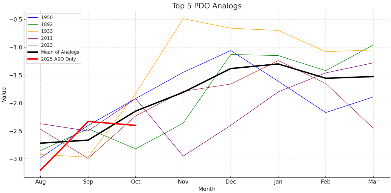
The closest five analog PDO cases (based on RMSE) suggest that the PDO will likely rise during the winter, but remain negative. If one looked at the top 10 cases, just one (2010-11) showed the PDO rising above zero during the winter. That case ranked 10th in terms of RMSE. The October 2025 PDO value was -2.40.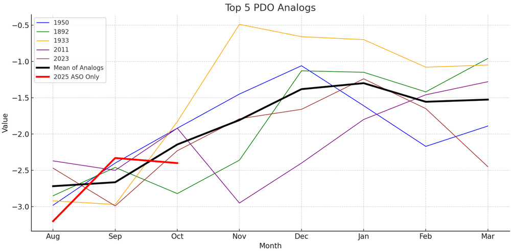
-
2025-2026 ENSO
donsutherland1 replied to 40/70 Benchmark's topic in Weather Forecasting and Discussion
I agree. The analog cases I used consider ENSO Region 1+2. -
2025-2026 ENSO
donsutherland1 replied to 40/70 Benchmark's topic in Weather Forecasting and Discussion
I see your point. The argument for RONI is that the overall warming of the Pacific is not temporary or cyclical. The use of traditional ENSO metrics i.e., R3.4 anomaly, ONI, etc., has beenb contaminated by the overall warming of the Pacific. In their present form, El Niño events are amplified while La Niña ones are shown as weaker. As the warming continues, La Niña events could even be obscured. Winter 2024-2025 is one such case. It showed up as neutral-cold on ONI, but was a La Niña case according to RONI. Some useful literature on the use of a relative index: https://iopscience.iop.org/article/10.1088/1748-9326/abe9ed https://journals.ametsoc.org/view/journals/clim/37/4/JCLI-D-23-0406.1.xml Australia's Bureau of Meteorology (BOM) has already made the switch to RONI. Here's a table from the article concerning the BOM's shift: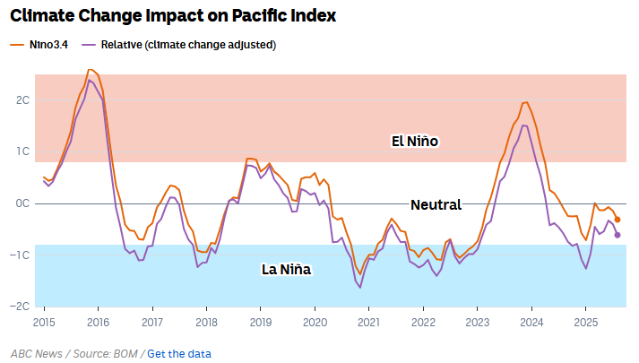
-
Winter 2025-2026 Thoughts
donsutherland1 replied to donsutherland1's topic in Weather Forecasting and Discussion
It could. That's the wild card so to speak. 2017-18 is in the analog mix. It saw 7.7" snow in December and 40.9" overall. 2016-17 had 3.2" in December and 30.2" overall.