donsutherland1
-
Posts
24,189 -
Joined
Content Type
Profiles
Blogs
Forums
American Weather
Media Demo
Store
Gallery
Everything posted by donsutherland1
-
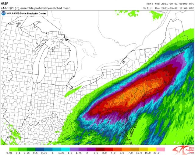
I’m not sure if that. The HREF has been very stable between its 0z and 12z runs.
- 511 replies
-
- 1
-

-
- heavy rain
- tropical gusts
- (and 1 more)
-
10-15. Orographic enhancement likely contributes.
- 511 replies
-
- 2
-
-

-
- heavy rain
- tropical gusts
- (and 1 more)
-
Through 11 am, Scranton has picked up 1.77” of rain. Much lighter amounts have been recorded in and around New York City and Newark. However, the main event will be tonight as Ida comes eastward. The 12z RGEM remains super aggressive. The 12z HREF shows the heaviest rains somewhat to the north and west of the RGEM. The National Blend of Models still shows 3.5”+ of rain overnight in EWR and NYC. So, considering the other guidance and somewhat discounting the RGEM as a worst-case scenario, it appears that NYC and EWR will probably see 3”-4” of rain. North and west of those regions, including northern New Jersey, Westchester/Rockland/Putnam/Dutchess Counties, into Connecticut, 4”-6” of rain with local amounts near or above 8” appears likely. Islip will probably see 2”-3” of rain, but some locally higher amounts are possible in Nassau and Suffolk Counties.
- 511 replies
-
- 3
-
-
-
- heavy rain
- tropical gusts
- (and 1 more)
-
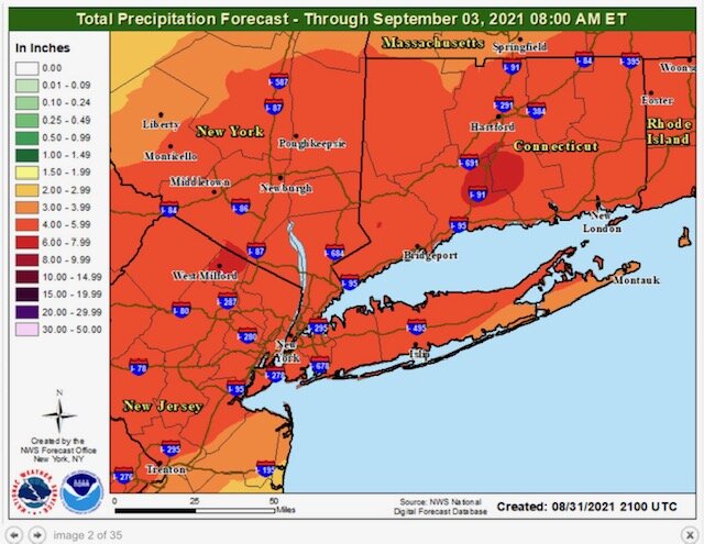
Morning thoughts... The remnants of Hurrican Ida will bring a soaking rain to much of the region today. A general 3"-6" rainfall (perhaps lower amounts in New York City and higher amounts north of the City) with locally higher amounts of 8" or more. Parts of eastern Pennsylvania to southern New Jersey could see a pronounced severe weather threat. Temperatures will likely the middle and upper 70s across much of the region. Likely high temperatures include: New York City (Central Park): 73° Newark: 76° Philadelphia: 82° Tomorrow will become partly sunny pleasant. Normals: New York City: 30-Year: 80.9°; 15-Year: 80.8° Newark: 30-Year: 82.3°; 15-Year: 82.3° Philadelphia: 30-Year: 83.5°; 15-Year: 83.2° 30-Day Verification: New York City (Central Park): Average daily forecast: 83.4° Average temperature: 83.9° Average error: 1.2° Newark: Average daily forecast: 87.7° Average temperature: 87.7° Average error: 1.6° Philadelphia: Average daily forecast: 87.2° Average temperature: 87.5° Average error: 1.7°
-
Not for NYC.
-
Arctic Sea Ice Extent, Area, and Volume
donsutherland1 replied to ORH_wxman's topic in Climate Change
That may explain why there has been no significant trend so far. -
Arctic Sea Ice Extent, Area, and Volume
donsutherland1 replied to ORH_wxman's topic in Climate Change
That’s based on the IPCC’s reference to “an earlier onset of surface melt in spring and a later freeze up in fall...” I am not aware of any meaningful changes in the mean or median dates of the summer minimum right now. -
Clouds will increase overnight. Some periods of light rain are possible during the morning. Tomorrow into Thursday will be cloudy with heavy rain likely. Much of the region will see a general 3"-6" of rain with local amounts at or above 8". Flash flooding is likely on account of the saturated ground from excessive August rainfall. High PWAT values in excess of 2" and strong frontogenic forcing, particularly tomorrow night, should produce a very intense period of rainfall in and around New York City. The latest National Model Blend guidance suggests that 3.50" of rain will fall in Central Park from 9/2 0z through 9/2 12z. It also suggests a storm total of around 5.00". Thus, it appears that Central Park will further extend its 15-day record for the 8/21-9/4 period. Based on 1971-2020 data, there is an implied 97% probability that New York City will pick up 50" or more precipitation this year. There is also an implied 40% probability that the City could pick up 60" or more precipitation. Since 1869, New York City has had 34 years with 50" or more precipitation (65% of which have occurred after 1970) and 8 years with 60" or more precipitation (all of which have occurred after 1970). Records go back to 1869. Despite a cooler than normal first 7-10 days, September will likely feature near normal to somewhat warmer than normal temperatures in much of the region. Fall 2021 will likely be wetter to much wetter than normal in the northern Middle Atlantic region. Since 1869, there have been 9 August cases where New York City picked up 20.00" or more rainfall during the summer. Two thirds of those cases (and 4/5 of those with summer mean temperatures of 73.0° or above) had 17.00" or more fall precipitation in New York City. 2011 is probably the closest match in terms of precipitation and a nearly identical summer mean temperature. Mean fall precipitation for those 9 cases was 14.86". The median was 17.35". The 1991-2020 normal value is 12.27". The ENSO Region 1+2 anomaly was 0.0°C and the Region 3.4 anomaly was -0.3°C for the week centered around August 25. For the past six weeks, the ENSO Region 1+2 anomaly has averaged +0.35°C and the ENSO Region 3.4 anomaly has averaged -0.47°C. Neutral ENSO conditions will likely prevail into at least mid-September. Afterward, La Niña conditions could begin to develop. The SOI was +25.43 today. The preliminary Arctic Oscillation (AO) figure was -1.752 today. On August 29 the MJO was in Phase 2 at an amplitude of 1.332 (RMM). The August 28-adjusted amplitude was 1.340 (RMM).
-
It will depend how active the tropics are. The pattern could again become favorable for U.S. landfalls around and after mid-September.
-
NWS Upton forecast map:
-
NYC is past 10” for August.
-
Just awful and tragic.
-
Arctic Sea Ice Extent, Area, and Volume
donsutherland1 replied to ORH_wxman's topic in Climate Change
That will probably become more frequent. -
Arctic Sea Ice Extent, Area, and Volume
donsutherland1 replied to ORH_wxman's topic in Climate Change
1895. -
DCA _ NYC _ BOS __ ORD _ ATL _ IAH __ DEN _ PHX _ SEA 0.4 0.5 0.5 0.8 0.0 -0.4 0.3 -0.3 1.0
-
Morning thoughts… Today will be partly to mostly cloudy and warm. A shower is possible in a few places, but most of the region should be dry. High temperatures will likely reach the middle and upper 80s in most of the region. Likely high temperatures around the region include: New York City (Central Park): 84° Newark: 88° Philadelphia: 85° Normals: New York City: 30-Year: 81.1°; 15-Year: 81.0° Newark: 30-Year: 82.5°; 15-Year: 82.5° Philadelphia: 30-Year: 83.7°; 15-Year: 83.4° Heavy rain from the remnants of Ida will impact the Middle Atlantic and southern New England regions during midweek. A general 3”-6” of rain with locally higher amounts is likely. Flash flood risks are elevate, as parts of the region have had an exceptionally wet last two weeks of August.
-
Arctic Sea Ice Extent, Area, and Volume
donsutherland1 replied to ORH_wxman's topic in Climate Change
Arctic sea ice extent dropped below 5 million square kilometers on JAXA to 4.988 million square kilometers on 8/30. Melt season will likely continue for another 1-3 weeks. -
I am not yet confident about the winter. How warm Region 1+2 is relative to Region 3.4 could make a big difference in the winter outcome.
-
12z GEFS for the 48-hour period ending 9/3 12z:
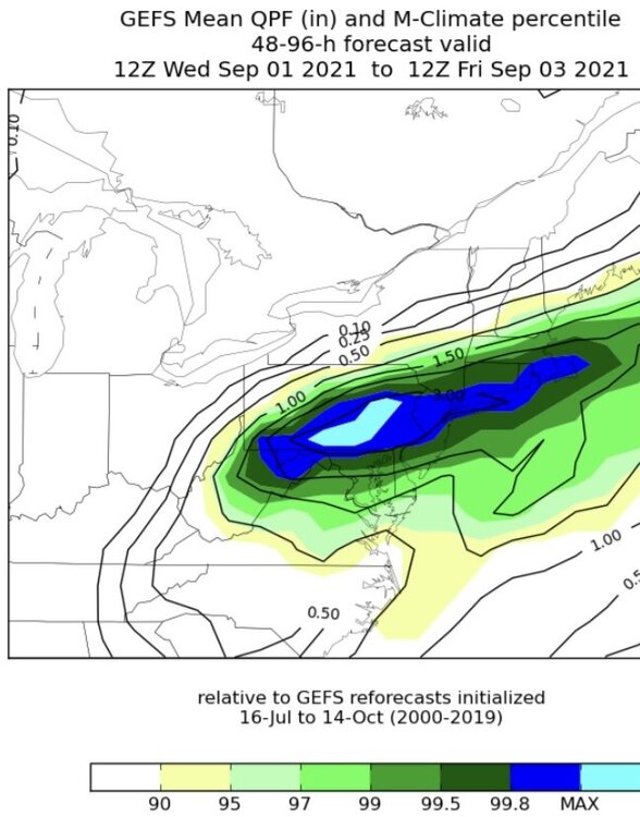
- 511 replies
-
- 2
-
-
- heavy rain
- tropical gusts
- (and 1 more)
-
Temperatures rose well into the 80s today in many parts of the region. Newark reached 90° for the 40th day this year and Baltimore reached 90° for the 50th time this year. Clouds will increase tomorrow ahead of moisture streaming northward from the remnants of IDA. It will be a warm day. Some locations could pick up a shower or thunderstorm. Wednesday into Thursday will be cloudy with heavy rain likely. Much of the region will see a general 2"-4" of rain with local amounts at or above 6". Flash flooding is likely on account of the saturated ground from excessive August rainfall. Overall, September will likely feature near normal to somewhat warmer than normal temperatures in much of the region. Fall 2021 will likely be wetter to much wetter than normal in the northern Middle Atlantic region. Since 1869, there have been 9 August cases where New York City picked up 20.00" or more rainfall during the summer. Two thirds of those cases (and 4/5 of those with summer mean temperatures of 73.0° or above) had 17.00" or more fall precipitation in New York City. 2011 is probably the closest match in terms of precipitation and a nearly identical summer mean temperature. Mean fall precipitation for those 9 cases was 14.86". The median was 17.35". The 1991-2020 normal value is 12.27". The ENSO Region 1+2 anomaly was 0.0°C and the Region 3.4 anomaly was -0.3°C for the week centered around August 25. For the past six weeks, the ENSO Region 1+2 anomaly has averaged +0.35°C and the ENSO Region 3.4 anomaly has averaged -0.47°C. Neutral ENSO conditions will likely prevail into at least mid-September. Afterward, La Niña conditions could begin to develop. The SOI was +28.22 today. The preliminary Arctic Oscillation (AO) figure was -1.399 today. On August 28 the MJO was in Phase 2 at an amplitude of 1.375 (RMM). The August 27-adjusted amplitude was 1.351 (RMM). Based on sensitivity analysis applied to the latest guidance, there is an implied near 100% probability that New York City will have a warmer than normal August (1991-2020 normal). August will likely finish with a mean temperature near 77.5° (1.5° above normal). Finally, with the Arctic Oscillation having turned negative, Arctic sea ice extent (JAXA) will likely fall below 5 million square kilometers for the first time this year in tonight's report for August 30.
-
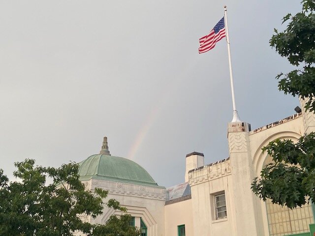
Rainbow at Rye, NY:
-
Morning thoughts… Today will be partly cloudy and warmer. A shower is possible in a few places, but most of the region should be dry. High temperatures will likely reach the middle and upper 80s in most of the region. Likely high temperatures around the region include: New York City (Central Park): 84° Newark: 88° Philadelphia: 88° Normals: New York City: 30-Year: 81.3°; 15-Year: 81.2° Newark: 30-Year: 82.7°; 15-Year: 82.7° Philadelphia: 30-Year: 83.9°; 15-Year: 83.6° Heavy rain from the remnants of Ida will likely impact the Middle Atlantic and southern New England regions during midweek. A general 2”-4” of rain with locally higher amounts is likely.
-
Tomorrow will be partly sunny and warmer. A few locations could see a shower or two. Looking farther ahead, September will likely feature near normal to somewhat warmer than normal temperatures overall. Ida is continuing to batter Louisiana after having made landfall with maximum sustained winds of 150 mph. Ida will slowly move away from New Orleans overnight, but not before dumping additional heavy rain and inflicting further wind-driven damage. Fall 2021 will likely be wetter to much wetter than normal in the northern Middle Atlantic region. Since 1869, there have been 9 August cases where New York City picked up 20.00" or more rainfall during the summer. Two thirds of those cases (and 4/5 of those with summer mean temperatures of 73.0° or above) had 17.00" or more fall precipitation in New York City. 2011 is probably the closest match in terms of precipitation and a nearly identical summer mean temperature. Mean fall precipitation for those 9 cases was 14.86". The median was 17.35". The 1991-2020 normal value is 12.27". The ENSO Region 1+2 anomaly was -0.1°C and the Region 3.4 anomaly was -0.9°C for the week centered around August 18. For the past six weeks, the ENSO Region 1+2 anomaly has averaged +0.41°C and the ENSO Region 3.4 anomaly has averaged -0.43°C. Neutral ENSO conditions will likely prevail into mid-September. Afterward, La Niña could begin to develop. The SOI was +13.59 today. The preliminary Arctic Oscillation (AO) figure was -0.963 today. On August 27 the MJO was in Phase 2 at an amplitude of 1.349 (RMM). The August 26-adjusted amplitude was 1.291 (RMM). Based on sensitivity analysis applied to the latest guidance, there is an implied near 100% probability that New York City will have a warmer than normal August (1991-2020 normal). August will likely finish with a mean temperature near 77.6° (1.6° above normal).