

donsutherland1
-
Posts
24,189 -
Joined
Content Type
Profiles
Blogs
Forums
American Weather
Media Demo
Store
Gallery
Everything posted by donsutherland1
-
In the wake of Ida's intense rainfall and devastating flooding, bright sunshine returned. The remainder of the week and weekend will feature abundant sunshine and cooler than normal readings. Despite a cooler than normal first 7-10 days, September will likely feature near normal to somewhat warmer than normal temperatures in much of the region. Fall 2021 will likely be wetter to much wetter than normal in the northern Middle Atlantic region. Since 1869, there have been 9 August cases where New York City picked up 20.00" or more rainfall during the summer. Two thirds of those cases (and 4/5 of those with summer mean temperatures of 73.0° or above) had 17.00" or more fall precipitation in New York City. 2011 is probably the closest match in terms of precipitation and a nearly identical summer mean temperature. Mean fall precipitation for those 9 cases was 14.86". The median was 17.35". The 1991-2020 normal value is 12.27". The ENSO Region 1+2 anomaly was 0.0°C and the Region 3.4 anomaly was -0.3°C for the week centered around August 25. For the past six weeks, the ENSO Region 1+2 anomaly has averaged +0.35°C and the ENSO Region 3.4 anomaly has averaged -0.47°C. Neutral ENSO conditions will likely prevail into at least mid-September. Afterward, La Niña conditions could begin to develop. The SOI was +2.74 today. The preliminary Arctic Oscillation (AO) figure was -1.499 today. On August 31 the MJO was in Phase 2 at an amplitude of 1.182 (RMM). The August 30-adjusted amplitude was 1.481 (RMM).
-
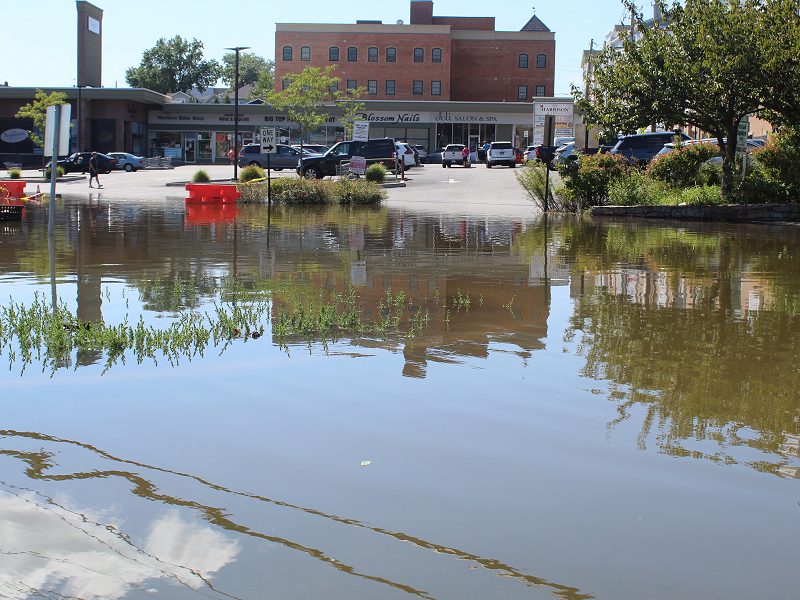
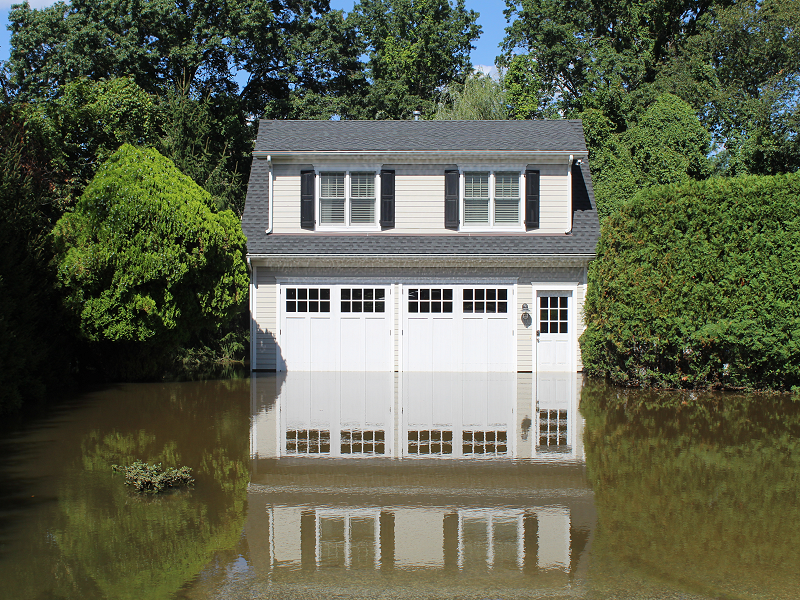
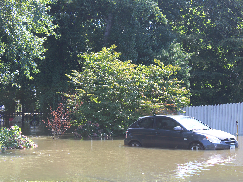
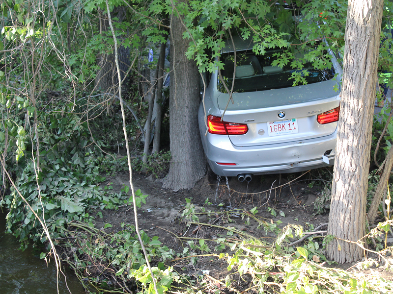
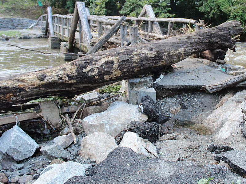
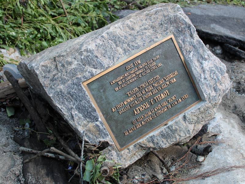
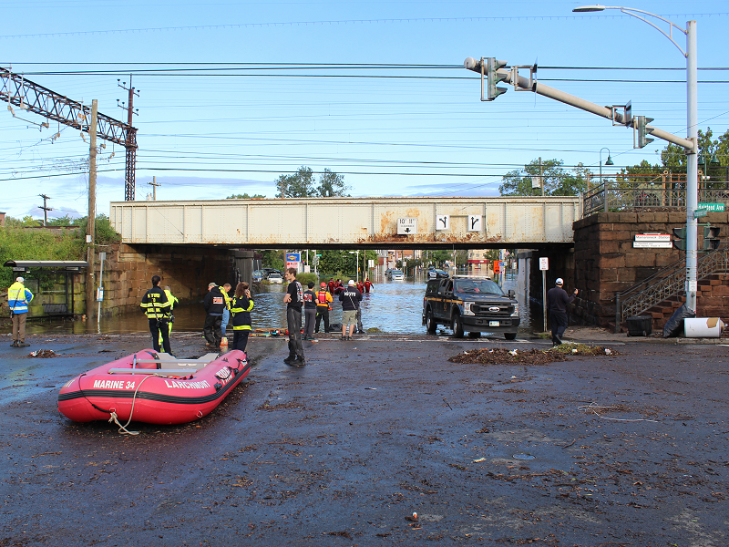
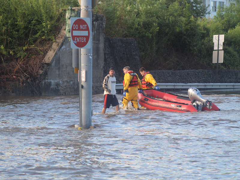
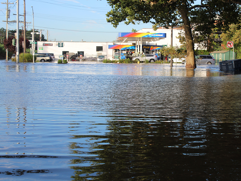
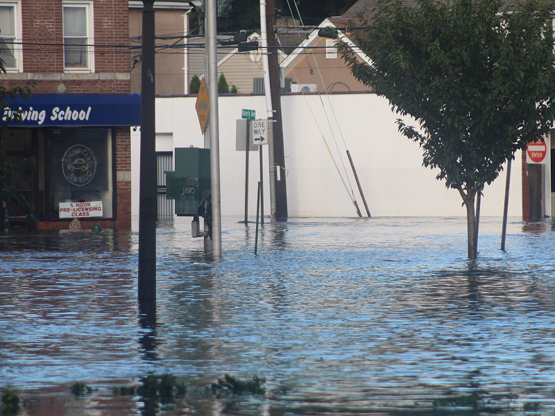
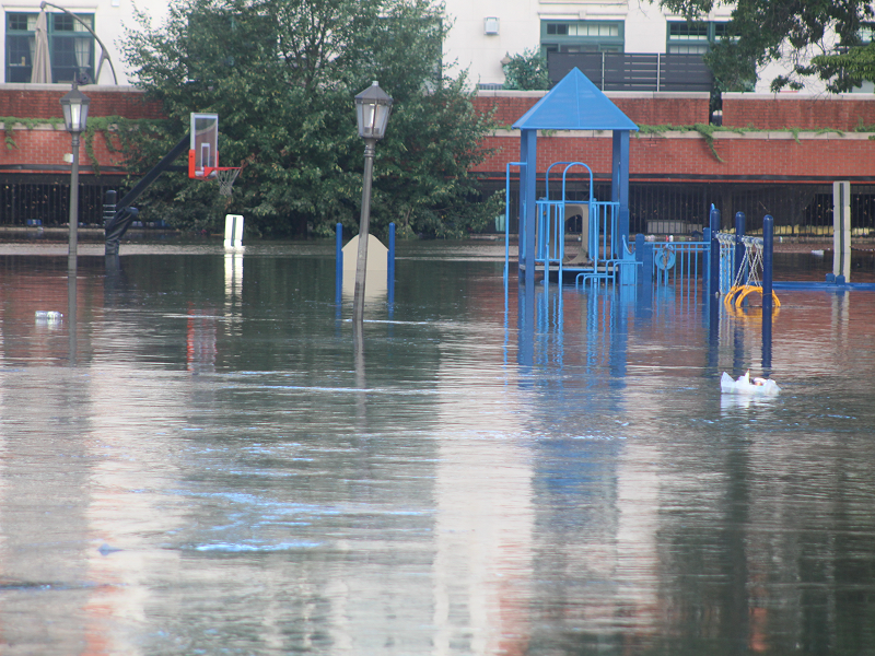
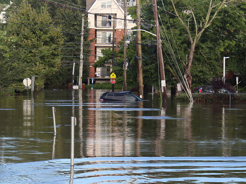
Some additional photos from the flooding and its aftermath: Photos: 1-3: Harrison, NY; 4: Larchmont, NY; 5-6: Scarsdale, NY
-
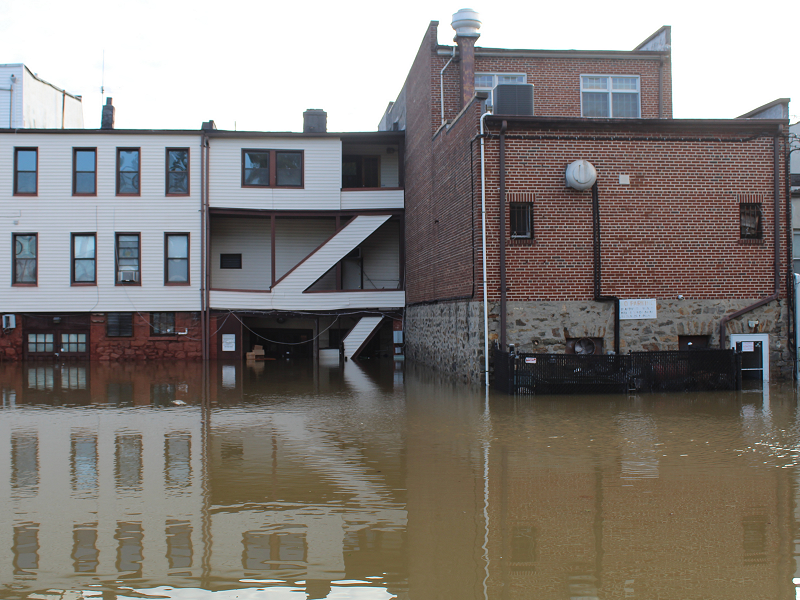
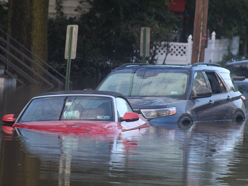
From Mamaroneck, NY:
-
The flood begins in Mamaroneck, NY last night:
-
Some photos from Mamaroneck, NY, which was hit hard by flooding:
-
Newark has now received 7.77” of rain. That surpassed the previous daily record of 7.69”, which was set on July 28, 1897.
-
Looking at older records that are not part of the threaded record for Newark that goes back to 1931, there was a 7.69” daily rainfall on July 28, 1897.
-
Looking at older records that are not part of the threaded record that goes back to 1931, there was a 7.69” daily rainfall on July 28, 1897.
-
Newark has now reached 6.79” of rain. That sets a new daily rainfall record. The old record was 6.73”, which was set on November 8, 1977.
-
Newark picked up 3.24” rain in the past hour.
-
I haven’t reviewed local storm reports.
-
Select daily precipitation records so far (through 8 pm): Harrisburg: 6.52" (old record: 3.60", 1952) Hartford: 1.38" (old record: 0.91", 1952) Mount Pocono: 4.72" (old record: 4.54", 1952) New York City-JFK: 0.68" (old record: 0.63", 2002) Philadelphia: 2.00" (old record: 1.80", 1952) Poughkeepsie: 2.76" (old record: 2.50", 1952) Scranton: 4.86" (old record: 2.59", 2003) York, PA: 6.51" (old record: 2.01", 2003)
-
Through 8 pm, Ida's remnants have already produced September 1 daily record rainfall totals in a number of locations including: Harrisburg: 6.52" (old record: 3.60", 1952) Hartford: 1.38" (old record: 0.91", 1952) Mount Pocono: 4.72" (old record: 4.54", 1952) New York City-JFK: 0.68" (old record: 0.63", 2002) Philadelphia: 2.00" (old record: 1.80", 1952) Poughkeepsie: 2.76" (old record: 2.50", 1952) Scranton: 4.86" (old record: 2.59", 2003) York, PA: 6.51" (old record: 2.01", 2003) Unofficially, Newark picked up 1.36" rain in the past hour. The last time Newark picked up 1.00" or more in an hour was June 26, 2020. This was also Newark's largest hourly rainfall since May 28, 2013 when 1.84" was measured. Ida will bring heavy rain and possible tornadoes to the region overnight into early tomorrow. Much of the region will see a general 3"-6" of rain with local amounts at or above 8". Flash flooding is likely on account of the saturated ground from excessive August rainfall. Based on 1971-2020 data, there is an implied 97% probability that New York City will pick up 50" or more precipitation this year. There is also an implied 40% probability that the City could pick up 60" or more precipitation. Since 1869, New York City has had 34 years with 50" or more precipitation (65% of which have occurred after 1970) and 8 years with 60" or more precipitation (all of which have occurred after 1970). Records go back to 1869. Despite a cooler than normal first 7-10 days, September will likely feature near normal to somewhat warmer than normal temperatures in much of the region. Fall 2021 will likely be wetter to much wetter than normal in the northern Middle Atlantic region. Since 1869, there have been 9 August cases where New York City picked up 20.00" or more rainfall during the summer. Two thirds of those cases (and 4/5 of those with summer mean temperatures of 73.0° or above) had 17.00" or more fall precipitation in New York City. 2011 is probably the closest match in terms of precipitation and a nearly identical summer mean temperature. Mean fall precipitation for those 9 cases was 14.86". The median was 17.35". The 1991-2020 normal value is 12.27". The ENSO Region 1+2 anomaly was 0.0°C and the Region 3.4 anomaly was -0.3°C for the week centered around August 25. For the past six weeks, the ENSO Region 1+2 anomaly has averaged +0.35°C and the ENSO Region 3.4 anomaly has averaged -0.47°C. Neutral ENSO conditions will likely prevail into at least mid-September. Afterward, La Niña conditions could begin to develop. The SOI was +9.03 today. The preliminary Arctic Oscillation (AO) figure was -1.846 today. On August 30 the MJO was in Phase 2 at an amplitude of 1.481 (RMM). The August 29-adjusted amplitude was 1.331 (RMM).
-
Approach of the heavy rain earlier this evening:
-
Through 7 pm, Harrisburg has seen 6.20” of rain. That is the 2nd biggest September daily rainfall and the 3rd biggest daily rainfall on record for that city.
-
Thanks. That’s great information.
-
Yes. That is true. Central and southern NJ could be at elevated risk for tornadoes.
- 511 replies
-
- 1
-

-
- heavy rain
- tropical gusts
- (and 1 more)
-
Harrisburg had 5.17” of rain as of 4:20. That is the 2nd wettest September day and only 5th day overall with 5” or more of rain. Records go back to 1888.
-
Through 3:56 pm, Harrisburg had picked up 4.75" of rain. That is the 2nd biggest daily rainfall on record in September and the 5th biggest daily rainfall overall. Heavy rain continued to fall. In the larger scheme of things, the consistent guidance shown on the 9/1 0z and 9/1 12z HREF seems to be verifying quite well. The northern most guidance is falling short. Thus, much of the New York City and Newark areas remain on track for 3"-6" of rain with local amounts of near or above 8". The heaviest amounts will likely be somewhat north and west of both cities.
- 511 replies
-
- 1
-
-
- heavy rain
- tropical gusts
- (and 1 more)
-
As of 3:05 pm, Harrisburg had picked up a September 1 record 4.08” of rain. Today is only the 8th September day on record with 4” or more of rain and the 7th wettest September day on record at that city. Records go back to 1888.
-
If they get near or reach their records, I will.
-
Through 2 pm, Scranton has picked up 2.84” of rain. That broke the daily record of 2.59” from 2003. Harrisburg had reported 3.51” of rain. That was just short of the daily record.
-
A heavy shower is moving through parts of southern Westchester County.

