

donsutherland1
-
Posts
23,768 -
Joined
Content Type
Profiles
Blogs
Forums
American Weather
Media Demo
Store
Gallery
Everything posted by donsutherland1
-
I agree with this quibble. I’ve sometimes mentioned sample size limitations and probably, but should do so more often. I note some cases/examples, e.g., 1958-58 in my commentary for purposes of illustration, but avoid references to analogs, as such references would go beyond the strength of relationships. Even an outcome that is 50% above climatology can still be a fairly low probability outcome. 10”+ snowstorms are uncommon events by any measure. Skill clearly dissipates as timeframes grow. Coefficients of determination also leave large parts of explanation beyond limited numbers of variables, especially as one considers the synoptic scale. Further complicating things is the reality of a dynamic climate that is altering existing relationships among variables. In the extended range, to use an analogy, one is always peering into the fog or mist of uncertainty. That’s why I embrace probabilistic language such as “likely,” and like CPC’s approach. Finally, models and ensembles have come far—and they consistently outperform the human level of skill—but they still have real limits. Machine learning/AI holds additional promise. How to convey the inherent uncertainty and limitations is a continuing question. I don’t have definitive answers to this question. Critiques are both welcome and helpful.
-
Given all the discussion in this thread--expressions of disappointment and frustration with the pattern evolution--I reviewed my posts concerning the ongoing pattern evolution for December 2022. I appear to have generally highlighted the need for caution. In addition, I mentioned unfavorable outcomes on multiple occasions. But some improvements could have been made, as noted later. As noted previously, forecasting in the medium-range and extended-range should be viewed in probabilistic, not deterministic terms. I've cited how I believe CPC's probabilistic approach to its 6-10-day, 8-14-day, and experimental 3-4-week forecasts is the way to go. I vigorously disagree with critics who proclaim that probabilistic forecasts are not forecasts. They are. That the critics don't appreciate or understand the application of probabilities is a completely separate issue. I will note that on social media, particularly Twitter and Facebook, sensationalism remains a genuine issue. Indeed, one tweet even suggested that the coming Great Lakes storm for December 22-24 could be analogous to a combination of the March 1993 superstorm and Blizzard of 1996. The former would be reasonable given the deepening that has been modeled and is still modeled. The latter was favored by only a small number of ensemble members (9/51 EPS members once favored 10" or more snow for NYC--a plurality but not majority--but just two showed 18" or more snow). What is said on social media is beyond what is discussed in this thread here. Social media should not skew perceptions of what is discussed in this thread or elsewhere on AmericanWx. @bluewave had repeatedly expressed a lot of caution, as well. Quite frankly, some of the information in this thread has consistently demonstrated greater insight, knowledge, and expertise than some of the sensationalist posts on Twitter (blizzard of 1996-type calls, 1983/1989-magnitude Arctic outbreak, etc.). Moreover, that's the norm when this forum is compared to Twitter and other social media forums. I don't like to have to make such comparisons, but it seems that social media perceptions have skewed perceptions of the better-informed discussions here, so pointing out the contrast is necessary and informative. And yes, "better-informed" is a deliberately-chosen accurate description. Facts, not sentimentalities, are vital. Having said that, perhaps on my end, I could have been more forceful in highlighting the level of uncertainty and risks for unfavorable outcomes. That this could be the first winter month on record (since 1950 when daily teleconnections data has been available) to see no measurable snowfall in NYC or Philadelphia despite a likely monthly average AO of -2.000 or below speaks to the uncommon nature of what is possibly going to unfold. No measurable snowfall is not yet assured, but the probability of that outcome has increased. Numerous examples from this thread follow. December 1: Potential could increase. Percentages provided for days with measurable snowfall and 1" or more snowfall for Boston, New York City, and Philadelphia: https://www.americanwx.com/bb/topic/58472-december-2022/?do=findComment&comment=6709110 Daily Discussion: "With the development of an EPO-/AO-/PNA- pattern, colder air intrusions could become more frequent after the first week of December. The potential for snowfall could also begin to increase." https://www.americanwx.com/bb/topic/58472-december-2022/?do=findComment&comment=6709893 Outcome: December 11-12: Snow coated the ground outside of New York City, including Newark (0.1") and Islip (0.4"). LaGuardia Airport also picked up 0.4" of snow. Another storm brought a moderate to significant snowfall to interior parts of the Northeast during the December 15-18 period, but none to the immediate New York City-Newark areas. December 2: Blocking patterns can take a long time to deliver snowstorms. November-December 2010 was provided as an example. https://www.americanwx.com/bb/topic/58472-december-2022/?do=findComment&comment=6711095 December 3: PNA: "By the end of the third week in December, values should be less negative than they currently are. However, the development of sustained positive values by that time seems unlikely (not zero, but still a less than one-in-three probability)." https://www.americanwx.com/bb/topic/58472-december-2022/?do=findComment&comment=6711896 Outcome: Through December 19, the PNA has remained < 0 December 3: "With the development of an EPO-/AO-/PNA- pattern following a short-lived rebound in the EPO to positive levels, colder air intrusions could again become more frequent toward mid-December. The potential for snowfall could also begin to increase, as well, as a sustained colder pattern begins to develop, but significant snowfall is not likely during the transition to that colder pattern." https://www.americanwx.com/bb/topic/58472-december-2022/?do=findComment&comment=6712062 December 5: "With the development of an EPO-/AO-/PNA- pattern following a short-lived rebound in the EPO to positive levels, colder air intrusions could again become more frequent toward mid-December. The potential for snowfall could also begin to increase, as well, as a sustained colder pattern begins to develop, but significant snowfall is not likely during the transition to that colder pattern. No severe cold is likely through at least the first three weeks of December. The latest EPS weeklies suggest that near normal to below normal temperatures could prevail during the December 19-26 period." https://www.americanwx.com/bb/topic/58472-december-2022/?do=findComment&comment=6714130 December 11: "A sustained colder pattern is currently developing. The latest EPS weeklies continue to suggest that near normal to below normal temperatures could prevail during the December 19-26 period. No severe cold is likely through at least the first three weeks of December. Afterward, as the PNA goes neutral, the prospect for snowfall and more significant cold could increase." https://www.americanwx.com/bb/topic/58472-december-2022/?do=findComment&comment=6722294 Outcome: 7 of the last 9 days have been cooler than normal in New York City (through December 19th). No severe cold has occurred through December 19th. December 13: "The probability of snowfall (measurable and significant) is notably higher than climatology during strong blocking patterns, especially when the PNA is positive at this time of year (and all of January). Higher probabilities are not guarantees. While the extreme blocking during 2010-2011 led to a big December blizzard and very snowy 30 days albeit after a long wait from late November, there have been cases where strong blocking did not produce such an outcome. Winter 1958-1959 is one such example." https://www.americanwx.com/bb/topic/58472-december-2022/?do=findComment&comment=6724692 December 15: "Here's what the two largest clusters look like for 12/23 (the first with 19 members has a Miller B-type scenario and probably comprises all 9 of the individual members showing 10" or more snow in the NYC-EWR areas; the second large group is very unfavorable for the coastal plain)." https://www.americanwx.com/bb/topic/58472-december-2022/?do=findComment&comment=6728734 Note: 9 of 51 EPS (17.6%) members showed 10" or more snow for the December 22-24 period at the time. December 16: "Phasing events are complex and details matter greatly. At extended ranges, even the best models don't fully resolve the details. With the PNA forecast to be rising to neutral or somewhat positive levels coupled with a strongly negative AO, the region has its highest probability relative to climatology for at least an appreciable snowfall. Nearly half of all December 16-31 days with 4" or more snowfall in either New York City, Newark, or Philadelphia during 1950-2021 have occurred with an AO-/PNA+ pattern (and two thirds of storms with daily snowfall of 4" or more in all three cities). There are no guarantees, of course. Some similar patterns deliver very little (December 1950). Others deliver large amounts of snow (December 2010 into January 2011)." https://www.americanwx.com/bb/topic/58472-december-2022/?do=findComment&comment=6732883 December 16: "Late next week could see another storm bring precipitation to the region. Model solutions range from accumulating snow in the New York City-Newark area to a potential Ohio Valley/Great Lakes blizzard. Details remain to be sorted out, but the latter scenario is currently the favored one on the ensembles. Once that storm passes, the season's coldest air so far will pour into the region." https://www.americanwx.com/bb/topic/58472-december-2022/?do=findComment&comment=6734163 December 17: "A powerful storm could bring heavy rain, high winds, and coastal flooding to the region late next week. A light snow accumulation remains possible at the onset of the storm and as it moves away from the region. Once that storm passes, the season's coldest air so far will pour into the region. Temperatures could tumble into the teens in New York City." https://www.americanwx.com/bb/topic/58472-december-2022/?do=findComment&comment=6737090
-
Dry but cool weather will continue through Wednesday. A powerful storm could bring heavy rain, high winds, and coastal flooding to the region Thursday and Friday. A general 1"-2" of precipitation appears likely with some locally higher amounts. A light snow accumulation remains possible at the onset of the storm and as it moves away from the region. A flash freeze is possible. Once that storm passes, the season's coldest air so far will pour into the region. Temperatures could tumble into the teens in New York City. Nevertheless, the core of the Arctic air mass will bypass the New York City region. The AO fell reached -4.000 on December 10th. Since 1950, there were 11 cases that saw the AO reach -4.000 or below during December. Mean snowfall for those cases was 9.0" (Median: 9.1"). 64% of such cases saw 6" or more of snowfall in December while 45% of such cases saw 10.0" or more snow. In contrast, during all other December cases, mean December snowfall was 3.5" (Median: 2.5"). 91% of those cases also saw a colder than normal December in the northern Middle Atlantic region. In terms of seasonal snowfall, 64% of those seasons saw 30" or more snowfall in New York City with 45% having 40" or more. Just 18% of such cases had less than 20" seasonal snowfall, both of which had less than 10" for the December-January period. However, there are cases where Decembers with strong blocking have seen much below normal snowfall. The three cases with less than 1" of monthly snowfall with a monthly average AO of -1.500 or below were: 1985: 0.9" (total seasonal snowfall: 13.0"); 1996: Trace (total seasonal snowfall: 10.0"); and, 2012: 0.4" (total seasonal snowfall: 26.1"). The lowest December snowfall when the AO averaged -2.000 or below was 5.1" in 1976. Total seasonal snowfall was 24.5". There is a chance that the December 1976 record futility could be surpassed this month. The ENSO Region 1+2 anomaly was -0.1°C and the Region 3.4 anomaly was -0.9°C for the week centered around December 14. For the past six weeks, the ENSO Region 1+2 anomaly has averaged -0.95°C and the ENSO Region 3.4 anomaly has averaged -0.92°C. La Niña conditions will likely persist through mid-winter. The SOI was +24.03 today. The preliminary Arctic Oscillation (AO) was -3.790 today. On December 17 the MJO was in Phase 3 at an amplitude of 0.644 (RMM). The December 16-adjusted amplitude was 0.602 (RMM). Based on sensitivity analysis applied to the latest guidance, there is an implied 77% probability that New York City will have a colder than normal December (1991-2020 normal). December will likely finish with a mean temperature near 37.7° (1.4° below normal).
-
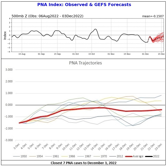
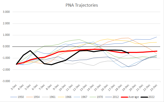
Here's how things have turned out so far with regard to the PNA:
-
Boston has 1.0” this month.
-
Not good news, but hot off the press:
-
This point about historical precedent is an important one. If one looks at social media, there are fairly widespread comparisons of the upcoming Arctic outbreak with those of 1983 and 1989. In fact, this outbreak will be notable for the past 30 years (especially given the warming of the climate that has occurred during that time), but it does not compare to those of 1983 and 1989 in terms of magnitude and duration. For example, during December 1983 and December 1989, Corpus Christi had two days during each outbreak with low temperatures below 20° (there are 5 such days in the historic record for December). There is currently an implied 10% chance that Corpus Christi will reach 19° or below at the height of the cold. At Galveston, both the 1983 and 1989 outbreaks had 2 such days (there are 5 such days in the historic record). There is currently an implied less than 1% chance that Galveston will record a temperature in the teens.
-
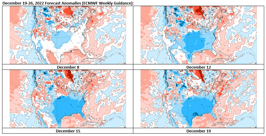
The EPS weeklies did a good job forecasting the now imminent Arctic outbreak showing cold anomalies in the eastern two-thirds of the CONUS for the December 19-26 period. The also showed cold anomalies for December 27-January 2 period albeit not as cold as those for the preceding week, which implied potential moderation toward the end of that week (now likely according to the guidance). On December 15th, they flipped to show cold anomalies continuing for January 3-9, but have now reversed to warm anomalies in the East.
-
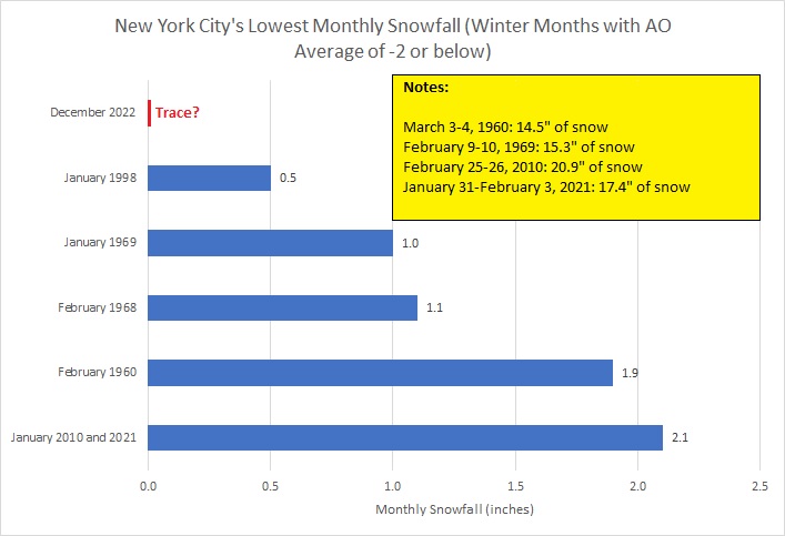
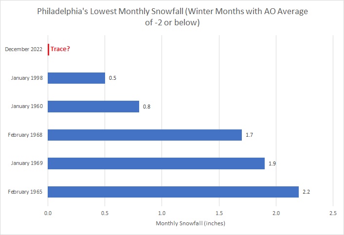
In much of the coastal plain, including New York City and Philadelphia, cold winter winds will howl at the end of the week, but snowflakes will be largely absent. As a result, there will be a growing chance that December 2022 could have the lowest snowfall for any winter month during with the Arctic Oscillation averaged -2.000 or below. January 1998 currently holds the record for New York City and Philadelphia. Monthly snowfall futility records for winter months with an AO average of -2.000 or below follow:
-
I think that, along with reduced intensity of the Arctic air masses, is a big reason why single digit readings in New York City and subzero lows outside of City with the exception of areas that radiate really well have become uncommon. Direct Arctic discharges from the north typically lead to the coldest temperatures. The upcoming Arctic air mass, which will set numerous records in the southern and central plains will be no exception. Its core will not reach Newark or New York City. As a result, Atlanta and Nashville will likely have lower minimum temperatures than New York City once December concludes. Savannah could come close to New York City's monthly minimum reading, too.
-
A warmup just before or around the New Year seems likely. Its duration and magnitude is far from certain. Some residual Atlantic blocking could persist in combination with a neutral or somewhat positive PNA. That could temper the warmth--warmer than normal at least for a time, but not necessarily record-challenging warmth. A popular argument might entail the MJO's returning to colder phases by mid-January (?) to argue for a return of colder weather, but MJO forecasts are low skill beyond 7-10 days.
-
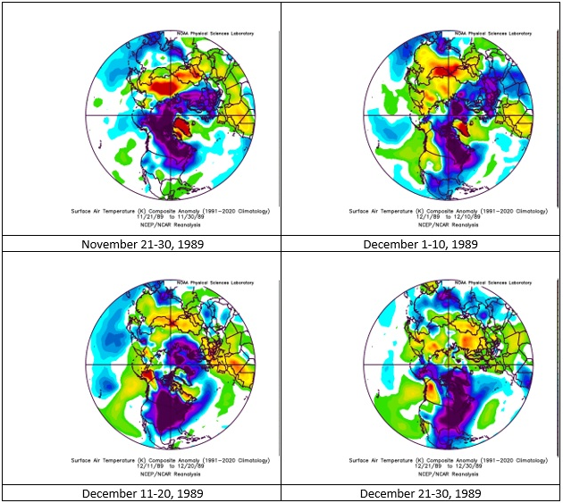
It was a combination of factors that led to a persistent period of much below normal temperatures: 1. An expansive pool of abnormally cold air had been located on our side of the Northern Hemisphere, which was reinforced by strong cross-polar flow 2. There had been a persistent PNA ridge 3. There had been a nearly three week period of strong Atlantic blocking The cross-polar flow ended around December 21 with Atlantic blocking ending a day later. There was a lag before the coldest air mass of the season could be scoured out of the eastern U.S. But that happened as December closed. The last day of December saw the mercury reach a monthly high of 53° in New York City. Prior to that, the monthly high had been 48°. Pacific flow developed. By mid-January 1990, strong Pacific flow prevailed and most of the cold was located over Eurasia. Sustained winter weather was largely finished. The upcoming cold air mass, which will likely set records in parts of the Southern and Central Plains later this week is not as cold nor as expansive as the frigid December 1989 air mass. Moreover, a larger area of cold is located over Eurasia and areas of much greater warmth than had been present in 1989 prevail over many other parts of the Northern Hemisphere.
-
There was a 19-day period of blocking (December 3-21). The AO fell below -3 on two days during that blocking. The blocking rapidly dissipated starting on December 22, the cold departed shortly afterward (but not before a historic Southeast snowstorm) and then the remainder of the winter was generally very mild. The monthly average AO was -0.621. This month, we'll likely average well below -2.
-
Morning thoughts… Today will be partly to mostly sunny and cool. High temperatures will reach the upper 30s and lower 40s in most of the region. Likely high temperatures around the region include: New York City (Central Park): 40° Newark: 41° Philadelphia: 41° The dry weather will continue through Wednesday. Normals: New York City: 30-Year: 43.3°; 15-Year: 44.1° Newark: 30-Year: 43.8°; 15-Year: 44.8° Philadelphia: 30-Year: 45.0°; 15-Year: 46.0°
-
December 1989 had 1.4” of snow. The remainder of the winter saw 7.3” of snow.
-
Dry but cool weather will continue through Wednesday. Afterward, a powerful storm could bring heavy rain, high winds, and coastal flooding to the region Thursday and Friday. A general 1"-2" of precipitation appears likely with some locally higher amounts. A light snow accumulation remains possible at the onset of the storm and as it moves away from the region. Once that storm passes, the season's coldest air so far will pour into the region. Temperatures could tumble into the teens in New York City. The AO fell reached -4.000 on December 10th. Since 1950, there were 11 cases that saw the AO reach -4.000 or below during December. Mean snowfall for those cases was 9.0" (Median: 9.1"). 64% of such cases saw 6" or more of snowfall in December while 45% of such cases saw 10.0" or more snow. In contrast, during all other December cases, mean December snowfall was 3.5" (Median: 2.5"). 91% of those cases also saw a colder than normal December in the northern Middle Atlantic region. In terms of seasonal snowfall, 64% of those seasons saw 30" or more snowfall in New York City with 45% having 40" or more. Just 18% of such cases had less than 20" seasonal snowfall, both of which had less than 10" for the December-January period. However, there are cases where Decembers with strong blocking have seen much below normal snowfall. The three cases with less than 1" of monthly snowfall with a monthly average AO of -1.500 or below were: 1985: 0.9" (total seasonal snowfall: 13.0"); 1996: Trace (total seasonal snowfall: 10.0"); and, 2012: 0.4" (total seasonal snowfall: 26.1"). The lowest December snowfall when the AO averaged -2.000 or below was 5.1" in 1976. Total seasonal snowfall was 24.5". There is a chance that the December 1976 record futility could be surpassed this month. The ENSO Region 1+2 anomaly was -0.7°C and the Region 3.4 anomaly was -1.0°C for the week centered around December 7. For the past six weeks, the ENSO Region 1+2 anomaly has averaged -1.23°C and the ENSO Region 3.4 anomaly has averaged -0.95°C. La Niña conditions will likely persist through mid-winter. The SOI was +28.39 today. The preliminary Arctic Oscillation (AO) was -4.236 today. On December 16 the MJO was in Phase 4 at an amplitude of 0.602 (RMM). The December 15-adjusted amplitude was 0.607 (RMM). Based on sensitivity analysis applied to the latest guidance, there is an implied 75% probability that New York City will have a colder than normal December (1991-2020 normal). December will likely finish with a mean temperature near 37.7° (1.4° below normal).
-
Some delayed thoughts on the use of computer models in meteorology, as I was watching the World Cup. IMO, the computer models have reached the stage where, if even top-of-the-line meteorologists competed against the models head-to-head without computer guidance, the models would consistently perform better. Of course, meteorologists recognize how valuable the models are and how much they have progressed. They provide amazing insight and are powerful forecasting tools. Not surprisingly, the models are used widely. As for the upcoming storm, even as a plurality of ensemble members briefly showed a significant snowfall, there was also a distinctive minority that showed the outcome that now seems most likely. And, as a cautionary note, the national blend of models showed 2.5" snow for the New York City. That was a reasonable starting point that should have grounded expectations.
-
Yes. Kasparov has noted how impressive AI has become. It has enormous potential if used wisely.
-
It did. It even learned how to make sacrifices.
-
FYI: https://www.ecmwf.int/sites/default/files/elibrary/2021/19877-machine-learning-ecmwf-roadmap-next-10-years.pdf
-
Morning thoughts… Today will be partly to mostly sunny and cool. High temperatures will reach the upper 30s and lower 40s in most of the region. Likely high temperatures around the region include: New York City (Central Park): 40° Newark: 43° Philadelphia: 42° The dry weather will continue through Wednesday. Normals: New York City: 30-Year: 43.5°; 15-Year: 44.3° Newark: 30-Year: 44.0°; 15-Year: 45.0° Philadelphia: 30-Year: 45.3°; 15-Year: 46.2°
-
Tomorrow will be another cool but dry day. A powerful storm could bring heavy rain, high winds, and coastal flooding to the region late next week. A light snow accumulation remains possible at the onset of the storm and as it moves away from the region. Once that storm passes, the season's coldest air so far will pour into the region. Temperatures could tumble into the teens in New York City. The AO fell reached -4.000 on December 10th. Since 1950, there were 11 cases that saw the AO reach -4.000 or below during December. Mean snowfall for those cases was 9.0" (Median: 9.1"). 64% of such cases saw 6" or more of snowfall in December while 45% of such cases saw 10.0" or more snow. In contrast, during all other December cases, mean December snowfall was 3.5" (Median: 2.5"). 91% of those cases also saw a colder than normal December in the northern Middle Atlantic region. In terms of seasonal snowfall, 64% of those seasons saw 30" or more snowfall in New York City with 45% having 40" or more. Just 18% of such cases had less than 20" seasonal snowfall, both of which had less than 10" for the December-January period. The ENSO Region 1+2 anomaly was -0.7°C and the Region 3.4 anomaly was -1.0°C for the week centered around December 7. For the past six weeks, the ENSO Region 1+2 anomaly has averaged -1.23°C and the ENSO Region 3.4 anomaly has averaged -0.95°C. La Niña conditions will likely persist through mid-winter. The SOI was +21.23 today. The preliminary Arctic Oscillation (AO) was -2.548 today. On December 15 the MJO was in Phase 4 at an amplitude of 0.606 (RMM). The December 14-adjusted amplitude was 0.655 (RMM). Based on sensitivity analysis applied to the latest guidance, there is an implied 74% probability that New York City will have a colder than normal December (1991-2020 normal). December will likely finish with a mean temperature near 37.7° (1.4° below normal).
-
Under partly sunny skies, the temperature topped out in the lower 40s today.

-
All the major models, except for the GFS, use the 4D-Var initialization scheme. NCEP decided to use something different rather than what remains the best-in-class approach. The growing gap in skill scores with two successive upgrades having slightly reduced scores over the versions they replaced are glaring red flags. Unfortunately, sunk cost fallacy seems to prevail and an inferior scheme is being retained.
-
The issue isn’t long-range forecasting per se, but long-range forecasting outside the context of probability. Skill deteriorates at longer timeframes. One should not view such forecasts through the lens of deterministic outcomes. Doing so can only lead to unnecessary and avoidable disappointment on account of an implicit underlying assumption that an outcome is guaranteed. That’s why, critics notwithstanding, I believe CPC’s 6-10/8-14 day forecasts using a probabilistic scheme are the way to go. They convey useful information and they respect uncertainty.


