donsutherland1
-
Posts
23,767 -
Joined
Content Type
Profiles
Blogs
Forums
American Weather
Media Demo
Store
Gallery
Everything posted by donsutherland1
-
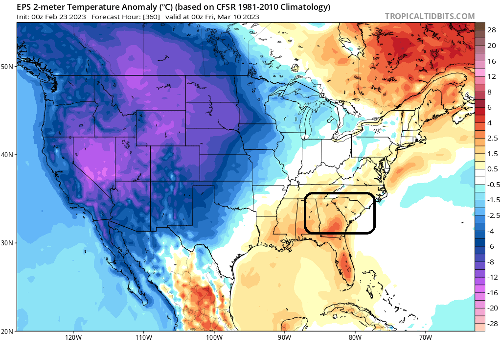
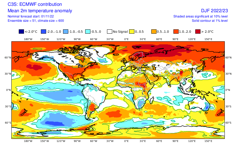
This map is in line with the Tropical Tidbits one when one considers the differences between Fahrenheit and Celsius.
-
The temperature order has been shattered. After spending the first 9 hours of the day at 38°, New York City saw the temperature rise to 39° at 10 am. Perhaps, that's a reminder that nothing is permanent, not even the seemingly endless snow drought plaguing parts the region.
-
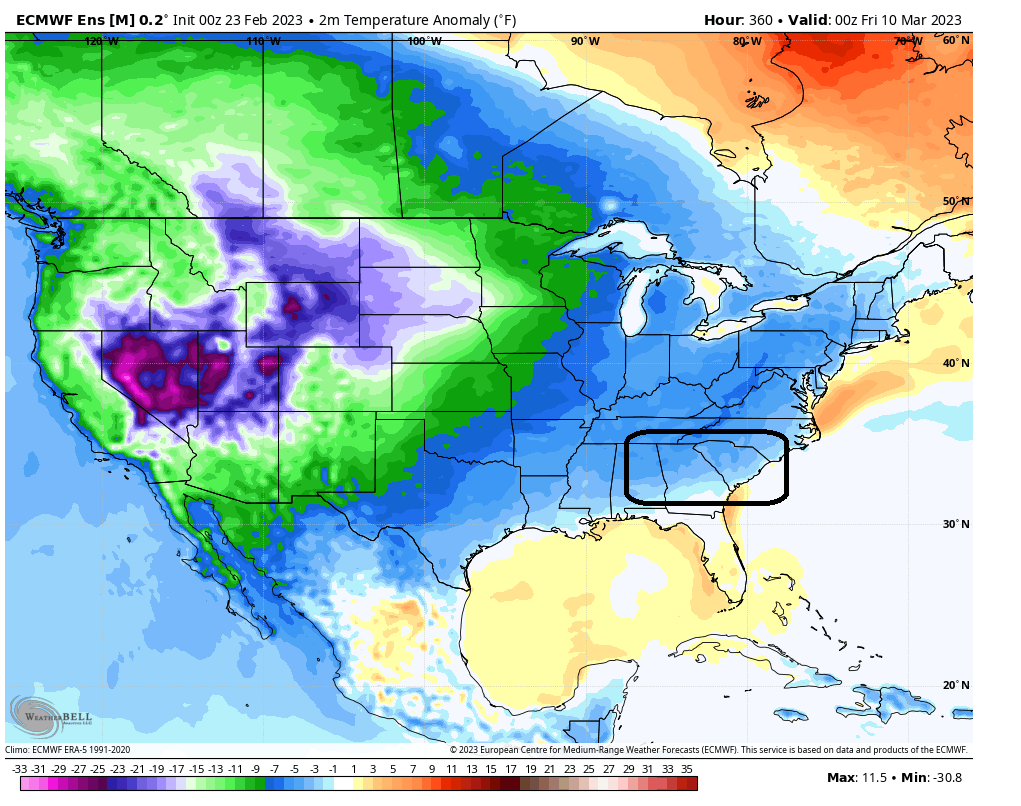
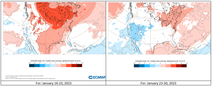
Which is right? Note the difference isn't in the use of Fahrenheit vs. Celsius. The difference is in whether the anomalies are warm or cold in parts of the Southeast. The upcoming weeklies for the March 6-13 period will probably offer a hint of where the European guidance is leaning. Tropical Tidbits: WeatherBell:


-
Here's what it looked like with March included. 2022-2023 isn't in March, so it doesn't appear on the chart.
-
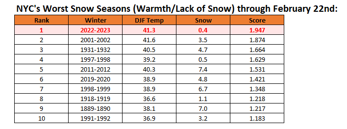
That’s the average through February 22. We could finish first if we don’t get much additional snowfall.
-
Morning thoughts… A warm front will stall near or just south of New York City. Along that front, it will be mostly cloudy. Some light rain or drizzle is possible. South of the front, it will be partly to mostly sunny and very warm. High temperatures will reach the upper 40s and lower 50s in most areas near the stalled front. South of the front, readings will soar into the upper 60s and lower 70s. Likely high temperatures around the region include: New York City (Central Park): 48° Newark: 51° Philadelphia: 71° A sharp but brief cold shot is likely this weekend. Normals: New York City: 30-Year: 43.9°; 15-Year: 44.0° Newark: 30-Year: 44.8°; 15-Year: 45.1° Philadelphia: 30-Year: 46.2°; 15-Year: 46.1°
-
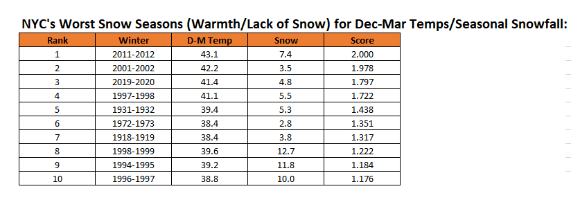
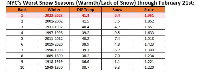
New York City's snow season futility rankings through February 22nd:
-
Parts of the region experienced light snow, flurries, and sleet as warmer air ahead of an advancing warm front began lifting over a retreating cooler air mass. Additional showers are likely tonight as a warm front approaches from the South. The warm front will likely stay just south of Newark and New York City tomorrow. South of the front, it will be unseasonably warm. The temperature will rocket into the lower and middle 70s in Philadelphia and reach or exceed 80° in Washington, DC. Parts of the Southeast could see daily record and monthly record high temperatures. Already, a number of record highs were set. Record highs included: Atlanta: 81° (old record: 79°, 2018) Louisville: 77° (old record: 76°, 1996) McAllen, TX: 98° (tied record set in 2017) Nashville: 79° (old record: 74°, 1897) Raleigh: 81° (old record: 79°, 2018) Wilmington, NC: 83° (old record: 81°, 2018) Zapata, TX: 98° (old record: 97°, 1996) Temperatures will run generally above normal through the much of the remainder of February. No severe shots of cold appear likely through February, though the weekend could start off with a fairly sharp cold shot. Among the extended range scenarios on the table is a late February-early March 2002-type outcome. Under such a scenario, cold air would flood into the Plains States, but persistent southeast ridging would keep most of the cold away from the northeastern and Mid-Atlantic United States. During February 28-March 5, 2002 high temperatures in the New York City area generally reached the lower to middle 40s with low temperatures in the 20s at night. At the height of the cold, one night saw the temperature fall into the upper teens. By March 7, the cold was gone and readings returned to much above normal levels. The first week of March could start with generally somewhat below normal temperatures. The latest ECMWF weekly forecast suggests that the second week of March could see near normal readings. Uncertainty remains high. In terms of snowfall prospects, a reasonable window of opportunity exists during the February 28-March 1 timeframe. EPS ensemble members have recently consolidated around that timeframe with about half of members showing 1" or more in New York City. Central New England and northern New England could see substantial snowfall. The ENSO Region 1+2 anomaly was +0.8°C and the Region 3.4 anomaly was -0.5°C for the week centered around February 15. For the past six weeks, the ENSO Region 1+2 anomaly has averaged +0.15°C and the ENSO Region 3.4 anomaly has averaged -0.56°C. La Niña conditions fading and they should evolve to neutral conditions during late winter or early spring. The SOI was -17.44 today. The preliminary Arctic Oscillation (AO) was +0.681 today. On February 20 the MJO was in Phase 7 at an amplitude of 1.542 (RMM). The February 19-adjusted amplitude was 1.719 (RMM). Based on sensitivity analysis applied to the latest guidance, there is an implied near 100% probability that New York City will have a warmer than normal February (1991-2020 normal). February will likely finish with a mean temperature near 41.4° (5.5° above normal).
-
If the two feet shown for Boston verifies, that would be a historic outcome. Boston has never had two feet of snow in March following a winter with less than 25" of snow through February. But warmer air holds more moisture, so if it's cold enough and there's a big storm, such an outcome can't be ruled out. Some quick statistics for March: Snowfall through February: < 15"; Snowiest March: 13.5", 2019 (0% of cases with 20" or more for March) Snowfall through February: < 20"; Snowiest March: 22.3", 1960 (6.5% of cases with 20" or more for March) Snowfall through February: < 25"; Snowiest March: 22.3", 1960 (4.5% of cases with 20" or more for March)
-
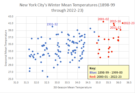
Scatter diagram of New York City's winter temperatures:
-
There are some snow flurries in the Bronx.
-
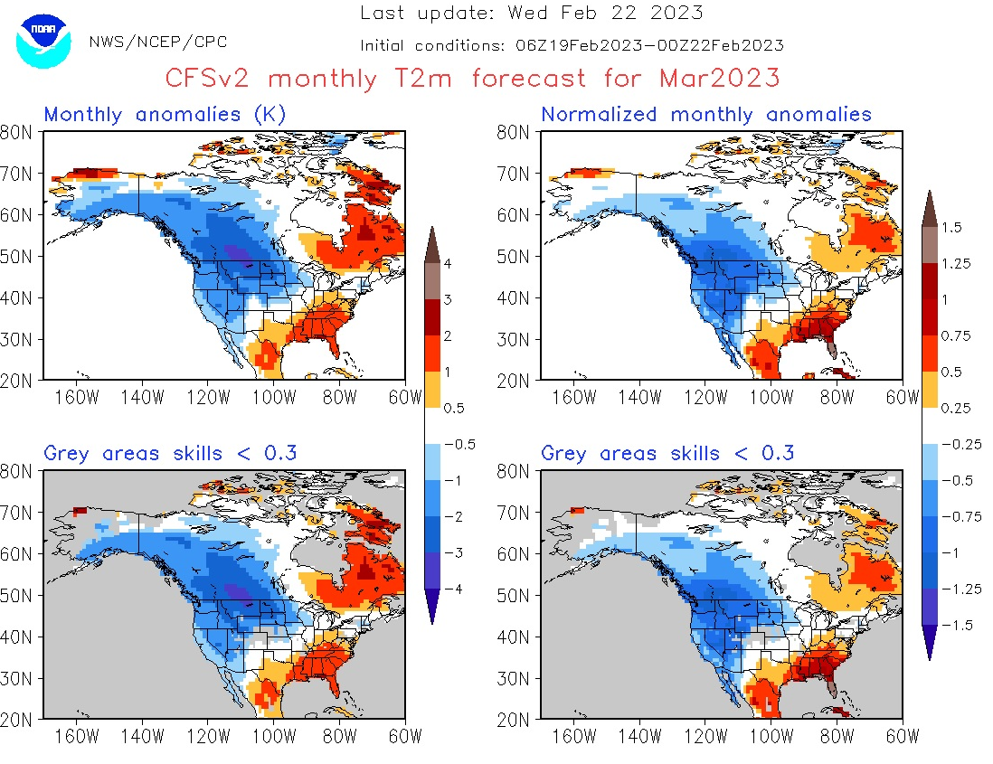
Good find. I didn't realize that the WeatherBell map was based on a single cycle. That's bad practice. 1. The sample size for the guidance is minimized over long timeframes (monthly period, in this case) increasing the risk of error. Under WeatherBell practice, one is essentially providing a monthly forecast from an operational model. That's worse than choosing the 15-day GFS forecast over a comparable EPS or GEFS forecast. This practice greatly increases the risk of error. 2. Even small changes between runs can lead to big differences in outcomes between cycles, generating a lot of noise from the run-to-run differences. Whipsawing between extremes doesn't build confidence in the forecasts. NCEP engages in far better practice from its using multiple runs. Sample size is increased and the forecasts are smoothed (essentially transforming the CFSv2 into a larger ensemble). NCEP uses the initial conditions from the most recent 3 days (12 runs) ending at 0z on the day the map is posted. Tropical Tidbits does, as well, but posts the maps 4 times per day. On account of the two issues cited above, it's difficult to argue that the WeatherBell maps are useful. The run-to-run discontinuity masks what could be a skillful signal, especially when one draws within 1-2 weeks of a forthcoming month. The lack of continuity is particularly damaging when one is trying to forecast at long timeframes where uncertainty is already very high. The WeatherBell practice also generates extremes that are unrealistic. There's no value in a map that shows a scenario that is all but certain to be far off what actually occurs. It will probably be useful for illustrative purposes to post the actual March outcome against the WeatherBell and NCEP maps. Finally, there has been a periodic debate on Social Media when users have posted even 10-day operational model maps depicting extreme outcomes. Most of the criticism of that practice--ranging from low probability of occurrence to skewing public perceptions--has come from private and public sector meteorologists. The posted WeatherBell map is an example of the kind practice that the meteorologists have found unhelpful or even harmful.
-
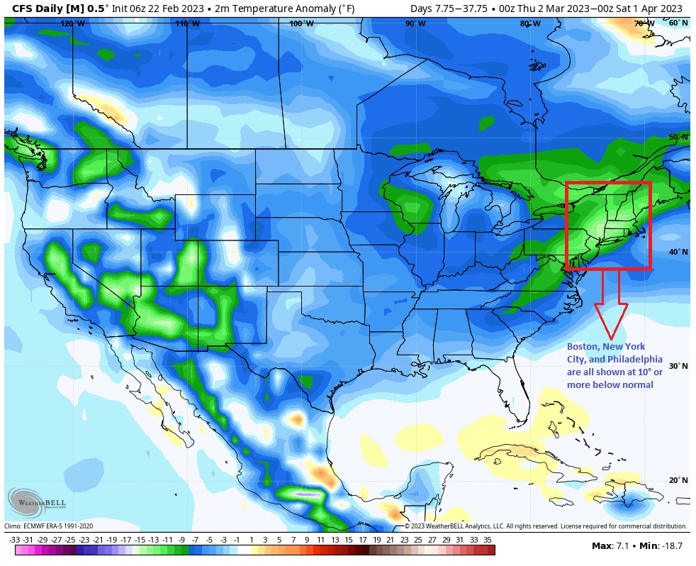
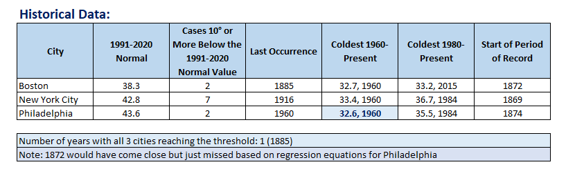
The below map was posted on Twitter to argue for an exceptionally cold March. I highlighted the section encompassing Boston, New York City, and Philadelphia. All three cities were shown on the map to have temperature anomalies of 10° or more below normal. The official CFSv2 site has a very different forecast for March. Notably, it is anything but as extreme as shown on the above chart. The difference between the charts should be a "red flag" for any serious analysis concerning the upcoming month. Historical data also suggests that the extreme nature of the forecast shown on the first chart would be extremely unlikely. Just one case (1885) from 1874 through 2022 saw March wind up 10° or more below the 1991-2020 normal value. In sum, some measure of due diligence should be undertaken when it comes to extreme values shown on monthly guidance. One should not accept the numbers at face value. One needs much more evidence, especially given the timeframe involved. Therefore, the extreme forecast shown on the first chart is all but certain to be wrong. Moreover, the big gap between that forecast and that shown on the official CFSv2 site argues that the first map's algorithm may be flawed. The difference between 3/2-4/1 on the first map and 3/1-31 on the official map (one day) is not sufficient to explain the exceptional difference in forecast outcomes.


-
4.5".
-
If experience elsewhere in the Mid-Atlantic region where it has been warming is representative, the mid-2040s could see JFK's average drop below 15". Central Park would fall into the teens, as well. There would continue to be snowy winters from time to time, but they would become more infrequent.
-
Both 2001-2002 and 2019-2020 had no measurable snowfall after January.
-
There is no perfect score, as those are standard deviations. If NYC stays below 1” of snow this winter, 2022-23 would probably be at or just above 2.0. I can construct a chart for the December-March period. Do you want total seasonal snowfall or December-March snowfall? Washington is more likely to reach 80 than Baltimore, but Baltimore has a chance.
-
Morning thoughts… Today will be mostly cloudy. Showers are likely during the afternoon and at night. High temperatures will reach the lower and middle 40s in most areas. Likely high temperatures around the region include: New York City (Central Park): 44° Newark: 45° Philadelphia: 47° Tomorrow will be mild. However,, from central New Jersey southward, it will be very warm. Philadelphia could see temperatures reach the lower and middle 70s. Washington, DC could reach or exceed 80°. Normals: New York City: 30-Year: 43.6°; 15-Year: 43.8° Newark: 30-Year: 44.6°; 15-Year: 44.8° Philadelphia: 30-Year: 45.9°; 15-Year: 45.8°
-
New York City's snow season futility rankings through February 21st:
-
Tomorrow will be mainly cloudy and cool. Some showers and perhaps a period of rain is possible. North and west of New York City and Newark, there could be some mixed precipitation. A minor accumulation is possible far north and west of the two cities. The warm front will likely approach New York City on Thursday. South of the front, it will be unseasonably warm. The temperature could rocket into the middle 70s in Philadelphia and reach or exceed 80° in Washington, DC. Parts of the Southeast could see not just daily record high temperatures, but also monthly records. Temperatures will run generally above to much above normal through the much of the remainder of February. No severe shots of cold appear likely through February, though the weekend could start off with a fairly sharp cold shot. Among the extended range scenarios on the table is a late February-early March 2002-type outcome. Under such a scenario, cold air would flood into the Plains States, but persistent southeast ridging would keep most of the cold away from the northeastern and Mid-Atlantic United States. During February 28-March 5, 2002 high temperatures in the New York City area generally reached the lower to middle 40s with low temperatures in the 20s at night. At the height of the cold, one night saw the temperature fall into the upper teens. By March 7, the cold was gone and readings returned to much above normal levels. The latest ECMWF weekly forecast suggests that the second week of March could see near normal readings. Uncertainty remains high. The ENSO Region 1+2 anomaly was +0.8°C and the Region 3.4 anomaly was -0.5°C for the week centered around February 15. For the past six weeks, the ENSO Region 1+2 anomaly has averaged +0.15°C and the ENSO Region 3.4 anomaly has averaged -0.56°C. La Niña conditions fading and they should evolve to neutral conditions during late winter or early spring. The SOI was -4.08 today. The preliminary Arctic Oscillation (AO) was +1.725 today. On February 19 the MJO was in Phase 7 at an amplitude of 1.717 (RMM). The February 18-adjusted amplitude was 2.007 (RMM). Based on sensitivity analysis applied to the latest guidance, there is an implied near 100% probability that New York City will have a warmer than normal February (1991-2020 normal). February will likely finish with a mean temperature near 41.3° (5.4° above normal).
-
I can't fully agree. The modeling did very well on temperatures but poorly on snowfall (which is beyond the skill of contemporary seasonal guidance). They were not in the "same boat" so to speak. Here's why: The seasonal models did remarkably well in forecasting a warm winter across much of the Northern Hemisphere, including the "non-winter" in Europe (JB had been calling for a severely cold European winter and, expressing political sentiments to go along with it, energy shortages). The ECMWF seasonal forecast: The outcomes (December 1-February 19): Seasonal guidance does poorly when it comes to snowfall, as it snowfall is a function of discrete events (precipitation and temperatures) that are beyond what is possible today. But the temperature idea was well done. Subseasonal Forecasts: But even if seasonal forecasts can be terrible when it comes to snowfall (I had expected somewhat above normal snowfall seasonally based on the limited experience with 3rd year La Niñas e.g., 2000-01), one could make skillful forecasts at the subseasonal range. Even as potential appeared from time to time in December, one needed to be cautious about assuming there would be a big snowstorm. As the events drew closer, it was clear that there would be no big snowstorms. The same held true throughout January and February to date. The subseasonal guidance (weeklies out to 2-3 weeks) and extended range of the EPS/GEFS did very well in telegraphing the persistent warmth in January and February. For example, below are charts from the weeks 3-4 periods on the January 2 ECMWF weeklies. At that time, Joe Bastardi was calling for the "hounds of winter" to "howl" from January 10-30. He posted maps of past severe cold shots to amplify his forecast. Every AmWx forecaster in the monthly forecast challenge for January saw a warmer than normal January in Boston, New York City, and Washington, DC. The same was true for February. The 11 forecasters who participated for both months had both January and February warmer than normal. Calling for Extremes: In general, one should not call for extremes without strong and sufficient evidence. One needs to respect uncertainty at extended ranges and context for such events. The March 1-April 15 call for NYC to have a mean temperature anomaly of 5° below normal and 20" of snowfall is an extreme forecast. The last such occurrence was in 1956. Such occurrences have occurred only during a handful of seasons. All of those seasons were during a notably colder climate regime. That the climate has changed rendering old analogs useless needs to be respected. Great forecasters are those who can adapt to change when their old frameworks and principles lose utility. Rigidity ultimately leads to forecasting failure when big change occurs.
-
Winter 2022-23: Tornado warnings: 1 Winter storm warnings: 0
-
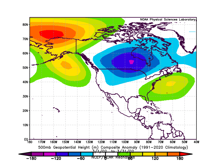
There were big differences at 500 mb. I just used a scenario for the opening of March. There is some promise on the longer-range ECMWF weeklies, but the skill scores are low out to 3-4 weeks and the mean temperatures are about 5° warmer than they are at the start of the month.
-
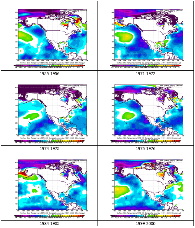
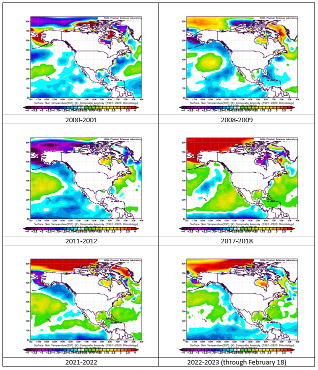
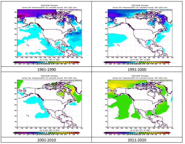
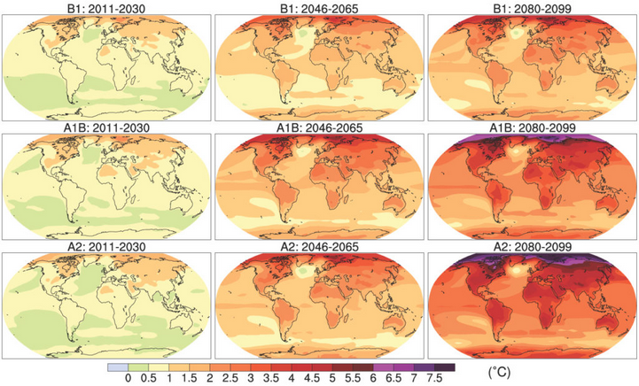
I believe that there is a lot more to the story. ENSO can have some impact via the upper air patterns, but there's more to the story. If one looks at all second and third year La Niña events, the Atlantic SSTA picture is mixed. The Atlantic anomalies are warmer in recent years and generally colder in earlier ones. That seems to reflect a longer-term evolution of SSTAs that is underway. Second and Third Year La Niña Events: Longer-Term Evolution of Atlantic SSTAs: Indeed, the longer-term evolution appears to be consistent with the expectations from the climate models for a range of scenarios. From the IPCC: