donsutherland1
-
Posts
23,766 -
Joined
Content Type
Profiles
Blogs
Forums
American Weather
Media Demo
Store
Gallery
Everything posted by donsutherland1
-
New York City has the lowest seasonal snowfall to date through March 23rd. Based on continuing ensemble guidance, there is little credible support for a late-season snowstorm in the New York City area. Instead, consistent with the very low snow cases through March 23rd, most or all of the snowfall this season is likely done.
-
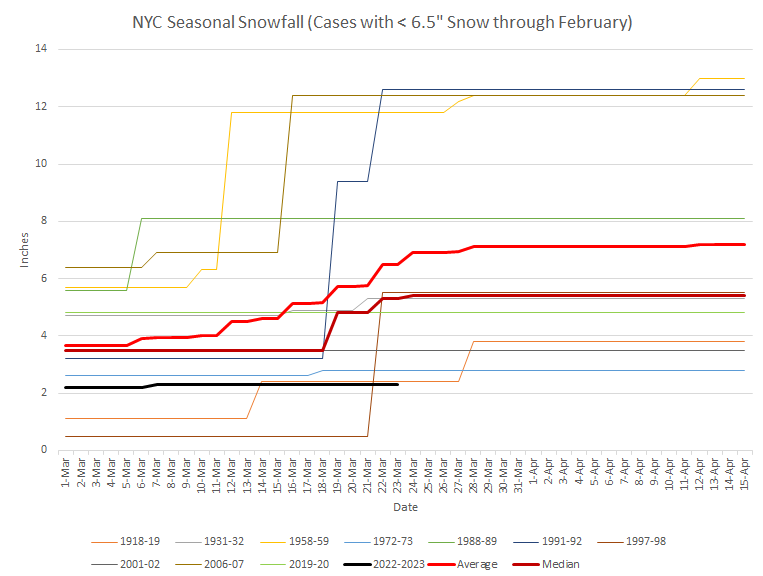
A frontal system extended across the northern Mid-Atlantic region today. The front separated mild air from exceptionally warm air. At Bridgeport, the temperature remained in the 50s. At Washington, DC, the mercury soared to 81°. Tomorrow will be another mild day albeit somewhat cooler than today. A storm will then bring a cold rain to the region to start the weekend. April could start on a cool, but not necessarily exceptionally cold note. As has been the case throughout the winter and early part of spring, the coldest air will likely remain in western and central North America. Historic experience with very low snowfall totals through February argues that a very snowy March or big snowstorm during March or April are unlikely. There were 16 winters that had less than 8" of snowfall through February in New York City. Just two (13%) had a 6" or greater snowstorm during March or April: 1889-1890: 6.0" on March 19th and 1991-1992: 6.2" on March 19th. With just 2.3" snowfall through March 19, New York City is now very likely to finish the season with less than 10" of snow. Since 1869-70, all 10 winters with less than 8.5" of snow through March 19th wound up with less than 10" of seasonal snowfall. New York City is currently on a path that could culminate in its setting a new record for lowest seasonal snowfall. The ENSO Region 1+2 anomaly was +1.4°C and the Region 3.4 anomaly was +0.1°C for the week centered around March 15. For the past six weeks, the ENSO Region 1+2 anomaly has averaged +0.98°C and the ENSO Region 3.4 anomaly has averaged -0.26°C. Neutral ENSO conditions will likely prevail through at least mid-spring. The SOI was +1.44 today. The preliminary Arctic Oscillation (AO) was +2.133 today. On March 21 the MJO was in Phase 2 at an amplitude of 1.730 (RMM). The March 20-adjusted amplitude was 1.850 (RMM). Based on sensitivity analysis applied to the latest guidance, there is an implied 88% probability that New York City will have a warmer than normal March (1991-2020 normal). March will likely finish with a mean temperature near 44.1° (1.3° above normal normal).
-
Unfortunately, it won’t last.
-
Morning thoughts… It will be mostly cloudy and mild. Some showers are possible High temperatures will reach the lower and middle 60s in most of the region. Likely high temperatures around the region include: New York City (Central Park): 62° Newark: 65° Philadelphia: 66° The mild weather will continue through tomorrow. Normals: New York City: 30-Year: 52.1°; 15-Year: 52.8° Newark: 30-Year: 53.1°; 15-Year: 54.0° Philadelphia: 30-Year: 55.2°; 15-Year: 55.9°
-
On this date in 1998, 5.0" of snow fell boosting winter 1997-98's seasonal snowfall to 5.5". As a result, with its 2.3" of snow to date, the 2022-23 snow season ranks as the least snowy season through March 22nd. Tomorrow will be mostly cloudy and very mild. Some showers are likely. Much of this week will feature readings in the 50s and even 60s. Overall, it now appears likely that March will wind up warmer than normal. April could start on a cool, but not necessarily exceptionally cold note. As has been the case throughout the winter and early part of spring, the coldest air will likely remain in western and central North America. Historic experience with very low snowfall totals through February argues that a very snowy March or big snowstorm during March or April are unlikely. There were 16 winters that had less than 8" of snowfall through February in New York City. Just two (13%) had a 6" or greater snowstorm during March or April: 1889-1890: 6.0" on March 19th and 1991-1992: 6.2" on March 19th. With just 2.3" snowfall through March 19, New York City is now very likely to finish the season with less than 10" of snow. Since 1869-70, all 10 winters with less than 8.5" of snow through March 19th wound up with less than 10" of seasonal snowfall. New York City is currently on a path that could culminate in its setting a new record for lowest seasonal snowfall. The ENSO Region 1+2 anomaly was +1.4°C and the Region 3.4 anomaly was +0.1°C for the week centered around March 15. For the past six weeks, the ENSO Region 1+2 anomaly has averaged +0.98°C and the ENSO Region 3.4 anomaly has averaged -0.26°C. Neutral ENSO conditions will likely prevail through at least mid-spring. The SOI was +6.75 today. The preliminary Arctic Oscillation (AO) was +2.080 today. On March 20 the MJO was in Phase 1 at an amplitude of 1.856 (RMM). The March 19-adjusted amplitude was 2.311 (RMM). Based on sensitivity analysis applied to the latest guidance, there is an implied 85% probability that New York City will have a warmer than normal March (1991-2020 normal). March will likely finish with a mean temperature near 44.1° (1.3° above normal normal).
-
Tomorrow will be another mild day, even as clouds increase. Much of this week will feature readings in the 50s and even 60s. Overall, it now appears likely that March will wind up warmer than normal. The latest weekly guidance suggests that April could start on a cool, but not necessarily exceptionally cold note. As has been the case throughout the winter and early part of spring, the coldest air will likely remain in western and central North America. Historic experience with very low snowfall totals through February argues that a very snowy March or big snowstorm during March or April are unlikely. There were 16 winters that had less than 8" of snowfall through February in New York City. Just two (13%) had a 6" or greater snowstorm during March or April: 1889-1890: 6.0" on March 19th and 1991-1992: 6.2" on March 19th. With just 2.3" snowfall through March 19, New York City is now very likely to finish the season with less than 10" of snow. Since 1869-70, all 10 winters with less than 8.5" of snow through March 19th wound up with less than 10" of seasonal snowfall. New York City is currently on a path that could culminate in its setting a new record for lowest seasonal snowfall. The ENSO Region 1+2 anomaly was +1.4°C and the Region 3.4 anomaly was +0.1°C for the week centered around March 15. For the past six weeks, the ENSO Region 1+2 anomaly has averaged +0.98°C and the ENSO Region 3.4 anomaly has averaged -0.26°C. Neutral ENSO conditions will likely prevail through at least mid-spring. The SOI was +3.01 today. The preliminary Arctic Oscillation (AO) was +1.582 today. On March 19 the MJO was in Phase 1 at an amplitude of 2.311 (RMM). The March 18-adjusted amplitude was 2.512 (RMM). Based on sensitivity analysis applied to the latest guidance, there is an implied 80% probability that New York City will have a warmer than normal March (1991-2020 normal). March will likely finish with a mean temperature near 44.1° (1.3° above normal normal).
-
Astronomical spring arrived yesterday. Today is the first full day of astronomical spring and it certainly feels like the season. If you're outdoors, enjoy it.
-
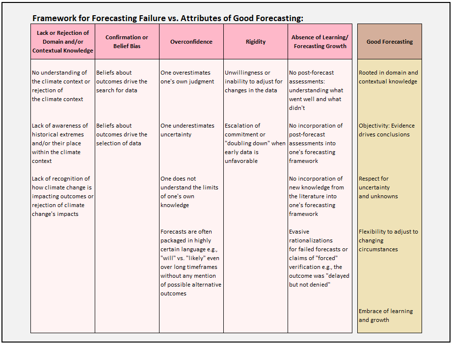
Continuing the discussion arising from high-visibility extreme forecasts continually pushed on Social Media that regularly fail, I ran through numerous tweets from calls about weather, climate, and markets. I also relied on literature relevant to forecasting and cognitive biases such as confirmation bias, anchoring, escalation of commitment, etc. Based on this assessment, I believe I have reasonably captured the elements of bad forecasting frameworks (I limited domain/contextual knowledge here to weather/climate given that this is a weather board) and those that define good forecasting. Good forecasting should not be confused with perfect forecasting. Good forecasting is defined by forecasts that consistently, but not always, prove realistic or reasonable against the outcomes of those forecasts. Error cannot be eliminated. However, in most cases, enormous errors are infrequent.
-
Morning thoughts… It will be partly sunny and mild. High temperatures will reach the upper 50s and lower 60s in most of the region. Likely high temperatures around the region include: New York City (Central Park): 59° Newark: 62° Philadelphia: 61° The mild weather will continue through Friday. Normals: New York City: 30-Year: 51.4°; 15-Year: 52.1° Newark: 30-Year: 52.4°; 15-Year: 53.3° Philadelphia: 30-Year: 54.4°; 15-Year: 55.1°
-
Much of this week will feature readings in the 50s and even 60s. Overall, it now appears likely that March will wind up warmer than normal. Historic experience with very low snowfall totals through February argues that a very snowy March or big snowstorm during March or April are unlikely. There were 16 winters that had less than 8" of snowfall through February in New York City. Just two (13%) had a 6" or greater snowstorm during March or April: 1889-1890: 6.0" on March 19th and 1991-1992: 6.2" on March 19th. With just 2.3" snowfall through March 19, New York City is now very likely to finish the season with less than 10" of snow. Since 1869-70, all 10 winters with less than 8.5" of snow through March 19th wound up with less than 10" of seasonal snowfall. New York City is currently on a path that could culminate in its setting a new record for lowest seasonal snowfall. The ENSO Region 1+2 anomaly was +1.4°C and the Region 3.4 anomaly was +0.1°C for the week centered around March 15. For the past six weeks, the ENSO Region 1+2 anomaly has averaged +0.98°C and the ENSO Region 3.4 anomaly has averaged -0.26°C. Neutral ENSO conditions will likely prevail through at least mid-spring. The SOI was -3.45 today. The preliminary Arctic Oscillation (AO) was +0.736 today. On March 18 the MJO was in Phase 1 at an amplitude of 2.510 (RMM). The March 17-adjusted amplitude was 2.593 (RMM). Based on sensitivity analysis applied to the latest guidance, there is an implied 78% probability that New York City will have a warmer than normal March (1991-2020 normal). March will likely finish with a mean temperature near 44.1° (1.3° above normal normal).
-
The storm's heaviest snow extended from eastern PA across central NJ. There were a lot of 16" and 17" amounts in that area with Philadelphia's 19.4" being perhaps the highest figure.
-
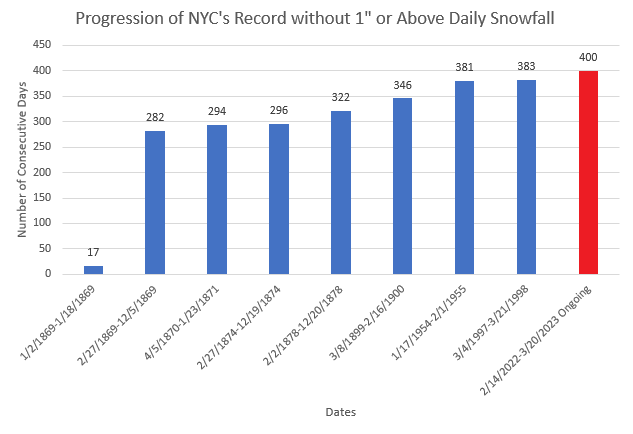
New York City's record-breaking stretch without 1" or more daily snowfall has reached 400 days today.
-
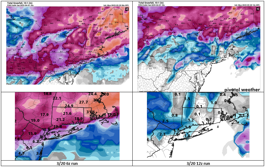
Same model (GFS), two runs:
-
Yes. Raleigh picked up 10". A photo from North Carolina's State Archives:
-
It seems that ever since the GFS went to the FV3 core, it periodically displays large spring snowfalls in the extended range. Its massive snowstorm for Boston a few days earlier than the one shown for the NYC area is also noted. Currently, the 6z run is on its own with its big snowfall solutions.
-
For NYC, it is probably the last freeze of the season. For the suburbs, it won't be.
-
Southampton had 16.0" in the April 3-4, 1915 snowstorm.
-
Morning thoughts… It will be mostly sunny and milder. High temperatures will reach the lower 50s in most of the region. Likely high temperatures around the region include: New York City (Central Park): 51° Newark: 54° Philadelphia: 53° The mild weather will continue through Friday.
-
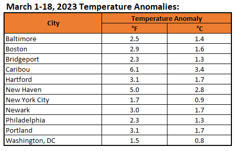
March temperatures have been running warmer than normal in the Northeast through March 18th:
-
Despite abundant sunshine, today was an unseasonably cool day. Like so often since December, the cold shot will be fleeting. Temperatures will rebound into the 50s tomorrow. Afterward, much the week will feature readings in the 50s and even 60s. Overall, it now appears likely that March will wind up warmer than normal. Historic experience with very low snowfall totals through February argues that a very snowy March or big snowstorm during March or April are unlikely. There were 16 winters that had less than 8" of snowfall through February in New York City. Just two (13%) had a 6" or greater snowstorm during March or April: 1889-1890: 6.0" on March 19th and 1991-1992: 6.2" on March 19th. With just 2.3" snowfall through March 19, New York City is now very likely to finish the season with less than 10" of snow. Since 1869-70, all 10 winters with less than 8.5" of snow through March 19th wound up with less than 10" of seasonal snowfall. New York City is currently on a path that could culminate in its setting a new record for lowest seasonal snowfall. The ENSO Region 1+2 anomaly was +1.5°C and the Region 3.4 anomaly was -0.1°C for the week centered around March 8. For the past six weeks, the ENSO Region 1+2 anomaly has averaged +0.76°C and the ENSO Region 3.4 anomaly has averaged -0.35°C. Neutral ENSO conditions will likely prevail through at least mid-spring. The SOI was -7.66 today. The preliminary Arctic Oscillation (AO) was -0.087 today. On March 17 the MJO was in Phase 1 at an amplitude of 2.594 (RMM). The March 16-adjusted amplitude was 2.770 (RMM). Based on sensitivity analysis applied to the latest guidance, there is an implied 75% probability that New York City will have a warmer than normal March (1991-2020 normal). March will likely finish with a mean temperature near 43.9° (1.1° above normal normal).
-
First, corrections for 1956, as I took the numbers from the wrong column: March 16-17: 4.2" March 18-19: 12.4" In terms of snowcover, March 1967 easily had more than 1956 at Patchogue (2 N): 1956: Peak snowcover: 10"; Average monthly snowcover: 0.6"; Biggest snowfall: 12.4", March 18-19 1967: Peak snowcover: 15"; Average monthly snowcover: 2.5"; Biggest snowfall: 16.1", March 22-23
-
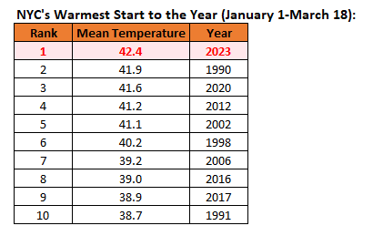
Through March 18th, 2023 is off the the warmest start on record for New York City. Four of the top five cases and seven of the top ten cases have occurred since 2000. All ten have occurred since 1990. New York City has had a mature urban footprint since the 1950s. Records go back to 1869.
-
Morning thoughts… It will be mostly sunny, windy and unseasonably cool. High temperatures will reach the lower 50s in most of the region. Likely high temperatures around the region include: New York City (Central Park): 41° Newark: 44° Philadelphia: 44° Milder air will return tomorrow and remain in place through the remainder of the week. Normals: New York City: 30-Year: 50.7°; 15-Year: 51.4° Newark: 30-Year: 51.7°; 15-Year: 52.6° Philadelphia: 30-Year: 53.7°; 15-Year: 54.3
-
Colder air is moving into the region. Tomorrow will be unseasonably cold with high temperatures reaching the upper 30s and lower 40s. A gusty wind will add to the chill. However, the parting shot of what had been an extraordinarily mild winter will be fleeting. Temperatures will rebound into the 50s on Monday with much the week featuring readings in the 50s and even 60s. No potential snowstorms appear likely through at least the end of next week. New York City is currently on a path that could culminate in its setting a new record for lowest seasonal snowfall. Overall, it now appears that March will wind up at least somewhat warmer than normal. It is also possible that New York City could see its last freeze of the season on tomorrow morning or Monday morning. Historic experience with very low snowfall totals through February argues that a very snowy March or big snowstorm during March or April are unlikely. There were 16 winters that had less than 8" of snowfall through February in New York City. Just two (13%) had a 6" or greater snowstorm during March or April: 1889-1890: 6.0" on March 19th and 1991-1992: 6.2" on March 19th. With just 2.3" snowfall through March 16, New York City has a high probability of finishing with less than 10" of snow. Since 1869-70, 88% of winters with less than 8" of snow through March 16 wound up with less than 10" seasonal snowfall. The highest seasonal amount in such cases occurred in 1991-1992 when 12.6" of snow was measured. By March 19th, all 10 winters with less than 8.5" of snow wound up with less than 10" of seasonal snowfall. The ENSO Region 1+2 anomaly was +1.5°C and the Region 3.4 anomaly was -0.1°C for the week centered around March 8. For the past six weeks, the ENSO Region 1+2 anomaly has averaged +0.76°C and the ENSO Region 3.4 anomaly has averaged -0.35°C. Neutral ENSO conditions will likely prevail through at least mid-spring. The SOI was -4.79 today. The preliminary Arctic Oscillation (AO) was -0.082 today. On March 16 the MJO was in Phase 1 at an amplitude of 2.784 (RMM). The March 15-adjusted amplitude was 3.114 (RMM). Based on sensitivity analysis applied to the latest guidance, there is an implied 67% probability that New York City will have a warmer than normal March (1991-2020 normal). March will likely finish with a mean temperature near 43.6° (0.8° above normal normal).
-
Nature has now made an irreversible commitment to spring at the New York Botanical Garden. Below are some photos from this afternoon: