donsutherland1
-
Posts
23,753 -
Joined
Content Type
Profiles
Blogs
Forums
American Weather
Media Demo
Store
Gallery
Everything posted by donsutherland1
-
Extreme Cold, Snow & Sleet: SECS 1/24 - 1/26
donsutherland1 replied to TriPol's topic in New York City Metro
So, it wasn't that storm. I am not sure what storm was involved. -
Extreme Cold, Snow & Sleet: SECS 1/24 - 1/26
donsutherland1 replied to TriPol's topic in New York City Metro
I was living in Washington, DC at the time and don't recall that storm. You might be referring to January 26, 1994, but I'm not completely sure. -
Extreme Cold, Snow & Sleet: SECS 1/24 - 1/26
donsutherland1 replied to TriPol's topic in New York City Metro
Maybe this?
-
Extreme Cold, Snow & Sleet: SECS 1/24 - 1/26
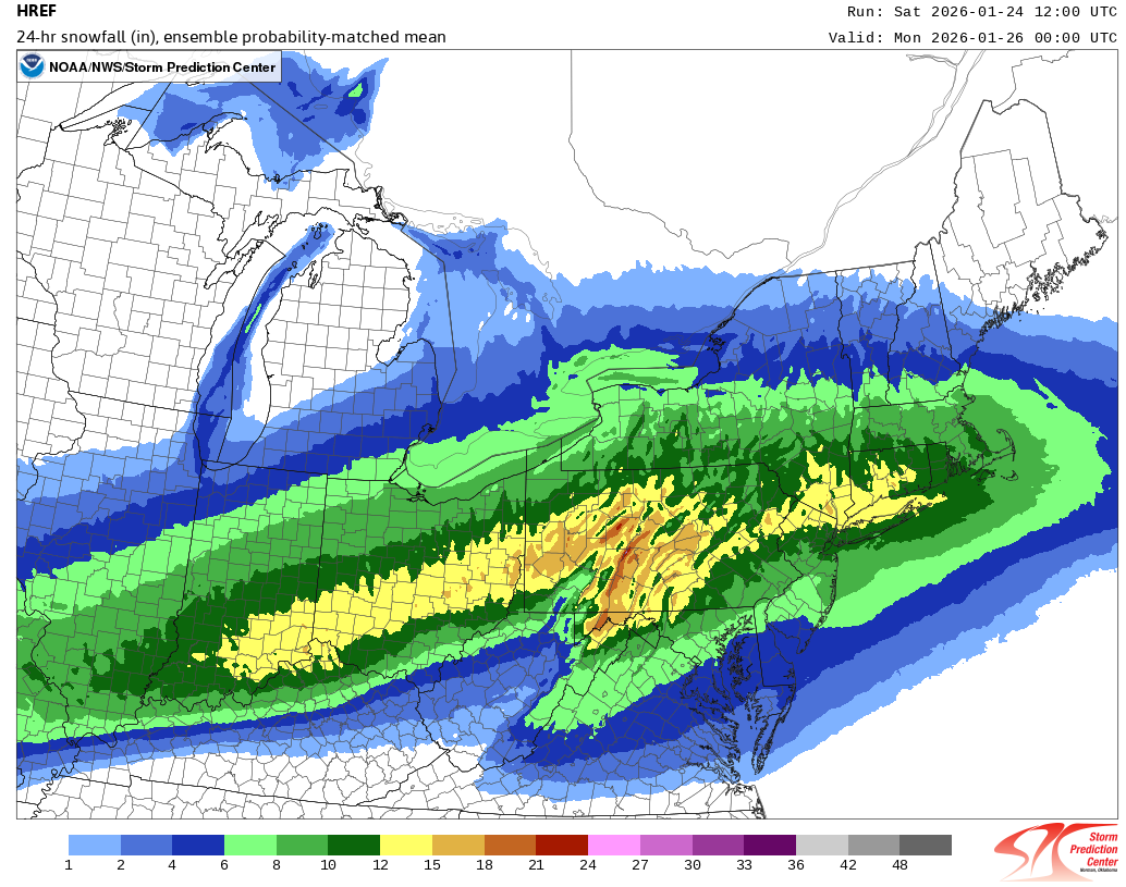
donsutherland1 replied to TriPol's topic in New York City Metro
For reference, here's the map though 1/26 0z. Typically, if one reduces the amounts by a category at this lead time, it's estimate is pretty good. As snow will continue to fall in parts of the Hudson Valley after 0z, it's current listing of 12"-15" there is reasonable. I think there will be some 18" amounts there.
-
Wintry mix is a more general description that includes any type of winter precipitation (snow, sleet, freezing rain). Snow/sleet is more specific.
-
Extreme Cold, Snow & Sleet: SECS 1/24 - 1/26
donsutherland1 replied to TriPol's topic in New York City Metro
The RGEM is late. Again. Right now, taking into consideration the early 12z guidance, my thinking is that a reasonable worst-case (least snowy) outcome for New York City is 5" (no real change from previous thinking). A reasonable best case is 12" (down 2" from previous thinking). For now, I'm still thinking that a 6"-12" range for storm total snow and sleet captures the most likely scenarios. Well north and west of the City, 12"-18" still appears likely. Areas south and east of the City and its nearby suburbs down to the central Jersey Shore and on eastern Long Island are in line for 4"-8". As a note, I am not fixated on any single model. My thinking takes into consideration the full range. No model has been dismissed at this time. Moreover, 100% of individual EPS members had a 6" or greater snowfall. I do think that the 12z HRRR was too snowy for New York City, but we'll see what the later guidance shows. By 18z and especially 0z, differences among the various models should narrow dramatically. All in all, this will still be New York City's biggest snowstorm in nearly four or perhaps five years. Personally, given the long snow drought, including the record 1,456 consecutive days without a 4" or greater daily snowfall (that includes today), I'll gladly accept the outcome that appears likely. Of course, I appreciate even the smaller events. -
Extreme Cold, Snow & Sleet: SECS 1/24 - 1/26
donsutherland1 replied to TriPol's topic in New York City Metro
At this stage, I'm using a combination of all of them. I think by 18z we'll see some convergence among them. I generally prefer the RGEM except when it's an outlier among the mesoscale models. Once we're < 24 hours out, I start giving more weight to the HRRR. -
Extreme Cold, Snow & Sleet: SECS 1/24 - 1/26
donsutherland1 replied to TriPol's topic in New York City Metro
I agree. I posted it, because a member mentioned that the 10:1 ratios don't reflect further north. I think it's too aggressive and too cold for the I-95 Corridor. -
Extreme Cold, Snow & Sleet: SECS 1/24 - 1/26
donsutherland1 replied to TriPol's topic in New York City Metro
Yes. I agree. The steady snow might not arrive in the Hudson Valley until 13z or 14z (northern Hudson Valley). -
Extreme Cold, Snow & Sleet: SECS 1/24 - 1/26
donsutherland1 replied to TriPol's topic in New York City Metro
On a more serious note regarding the NAM, the RGEM's high-resolution model and most of the global models use 4dVAR (four-dimensional variation) initialization. The NAM uses the older 3dVAR (three-dimensional variation) initialization. The general idea of warmer air moving in to change the snow to sleet in coastal areas and the New York City area and its nearby suburbs is the baseline idea due to lots of support. It's uncertain whether the NAM is overdoing things on account of its older initialization scheme or if it sees something the other guidance doesn't. If it begins to adjust late today (18z or later), that could be an indication that the older initialization process was playing a role. If, on the other hand, the other guidance starts shifting, that will indicate that the NAM, despite its limitations, had correctly resolved some of the details ahead of the other guidance. -
Extreme Cold, Snow & Sleet: SECS 1/24 - 1/26
donsutherland1 replied to TriPol's topic in New York City Metro
Adapted from Tayor Swift's "We Are Never Ever Getting Back Together." We hadn’t synced a single run all month, ’Cause you said you needed space (What?) Then you come around again and say, “NAM, I miss you, swear the PNA’s gonna change, trust me.” Remember how that lasted for a day? You ditch me when the ridge* is gone, Then beg me for that coastal bomb— “Show snow!” you plead. But I’ve evolved, I’m done, I’ve got a mission: sabotage. ’Cause I am never, ever, ever, ever showing snow together. Like, ever. I’m gonna warm-nose every layer, Torch the mid-levels ’til you suffer. I’m never, ever, ever, ever showing snow together. Like, ever. Oh, you blamed me when the PNA stayed negative, Ghosted me for globals, called me “clown guidance,” so repetitive. So now I’m cranking 850s warm, Killing totals storm by storm, And every run you beg and pray— I’ll melt it all away… ’Cause I am never, ever, ever, ever showing snow together. Like, ever. I’ll overdo the mixing, I’ll break your wintry fever. Yeah, we are never, ever, ever, ever getting snow together— Like, ever. *-PNA Ridge -
Extreme Cold, Snow & Sleet: SECS 1/24 - 1/26
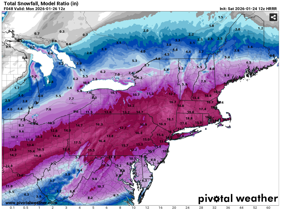
donsutherland1 replied to TriPol's topic in New York City Metro
Here's the HRRR's total snowfall map using the model's own assessment of the snow-liquid ratio:
-
Extreme Cold, Snow & Sleet: SECS 1/24 - 1/26
donsutherland1 replied to TriPol's topic in New York City Metro
Despite what seemed like a lengthy funeral oration for a storm that had yet to arrive following the 1/24 6z NAM and GFS runs, things still seem reasonably on course for a significant snowfall across the New York City region. 1) The models have been shifting about. One shouldn't focus only on the best or worst models. 2) The UKMET has slowly started paring back its precipitation hole. Some have affectionately nicknamed it "Crazy Uncle" for its occasional eccentricities. The 1/24 0z ECMWF improved over the 1/23 12z run. 3) 700 mb frontogenic forcing looks to be explosive for three and maybe four hours at a time when snow growth will be ideal. Four hours of 1"-2" per hour snowfall rates would yield 4"-8"; 0.60" QPF at 12:1-13:1 ratios would yield 7.2"-7.8". Take the low figures and that's probably the floor. Overall, New York City and nearby areas remain in line for 6"-12" of snow and sleet. Areas to the south and east of New York City could see 4"-8" amounts (even farther south beyond the New York City area, places like Atlantic City should see 3"-6"). General 12"-18" amounts are likely well north and west of New York City, most likely in parts of northeastern Pennsylvania (Pike County, Lackawanna County), Orange County, Dutchess County, and Sussex County. -
Extreme Cold, Snow & Sleet: SECS 1/24 - 1/26
donsutherland1 replied to TriPol's topic in New York City Metro
The RGEM is running. -
Extreme Cold, Snow & Sleet: SECS 1/24 - 1/26
donsutherland1 replied to TriPol's topic in New York City Metro
And the GFS was first to bring it back. For a time, it was the only model showing a big storm, but its solutions were dismissed on grounds that they were the result of initialization errors. -
Extreme Cold, Snow & Sleet: SECS 1/24 - 1/26
donsutherland1 replied to TriPol's topic in New York City Metro
Almost all of the guidance, including the NAM have the 875 mb layer down to the surface well below freezing. That would produce sleet. Some freezing drizzle can't be ruled out at some point, but the steady precipitation following the changeover from snow should be sleet. -
Extreme Cold, Snow & Sleet: SECS 1/24 - 1/26
donsutherland1 replied to TriPol's topic in New York City Metro
For trivia, the biggest daily snowfall difference between JFK and LGA is 8.5". On February 17, 2003, JFK saw 21.6" while LGA saw 13.1". -
Winter 2025-26 has seen Phoenix's warmest December 1-January 22 period on record.
-
Extreme Cold, Snow & Sleet: SECS 1/24 - 1/26
donsutherland1 replied to TriPol's topic in New York City Metro
The latest image came out very small. Here's the bigger one: -
Extreme Cold, Snow & Sleet: SECS 1/24 - 1/26
donsutherland1 replied to TriPol's topic in New York City Metro
Yes. Here’s the NWS forecast: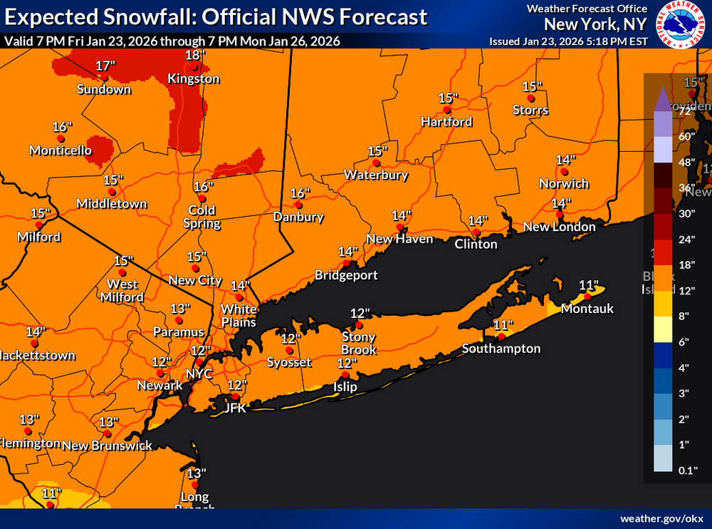
-
Extreme Cold, Snow & Sleet: SECS 1/24 - 1/26
donsutherland1 replied to TriPol's topic in New York City Metro
That was a rapidly strengthening coastal low. https://www.weather.gov/phi/eventreview20220129 https://bluehill.org/historic-blizzard-of-2022-impacted-new-england-with-strong-winds-and-record-snowfall/ -
Extreme Cold, Snow & Sleet: SECS 1/24 - 1/26
donsutherland1 replied to TriPol's topic in New York City Metro
Here it is: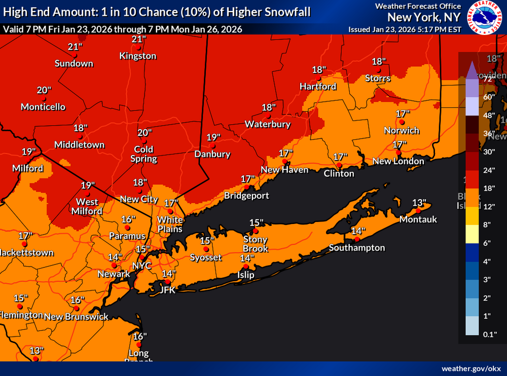
-
Extreme Cold, Snow & Sleet: SECS 1/24 - 1/26
donsutherland1 replied to TriPol's topic in New York City Metro
Even at the low-end NWS forecast, one sees a decent snowfall.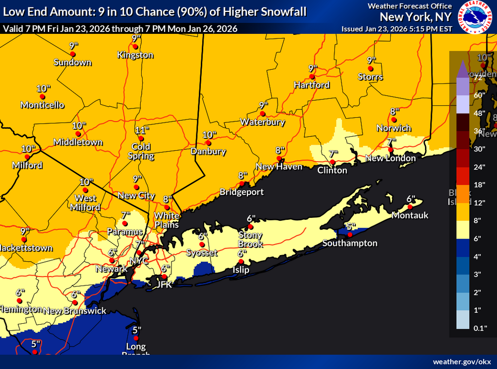
-
The Arctic Oscillation has averaged -0.433 this winter. 65% of days have seen a negative AO and 44% have seen the AO at -1.000 or below. Winter 2024-2025 had an AO average of -0.498 through January 23. Arctic air will pour into the region tonight. That will set the stage for the region's biggest snowstorm so far this winter and in a number of years. The temperature will likely stay below 20° in New York City and much of the region tomorrow. The last time that happened in New York City was January 21, 2025 when the high was 19°. Snow will arrive early on Sunday. A significant snowfall is likely in and around the New York City area and surrounding region, even as a transition to sleet is likely. At present, it appears that New York City and its nearby suburbs are in line for 6"-12" of snow. Areas to the north and west of the City where ratios will be higher and mixing is less likely will likely see 12"-18" of snow. Lesser amounts of 4"-8" appear likely along the central Jersey Shore and across eastern Long Island. Initial estimates: Albany: 12"-18" Allentown: 12"-18" Atlantic City: 3"-6" Baltimore: 6"-12" Binghamton: 12"-18" Boston: 12"-18" Bridgeport: 8"-14" Concord: 12"-18" Hartford: 12"-18" Islip: 4"-8" New York City: 6"-12" Newark: 6"-12" Philadelphia: 6"-12" Poughkeepsie: 12"-18" Portland: 14"-22" Providence: 12"-18" Richmond: 3"-6" Scranton: 12"-18" Washington, DC: 6"-12" The last time New York City saw a 6" or greater snowfall was January 28-29, 2022 when 8.3" fell. Its last 10" or above snowfall occurred during January 31-February 3, 2021 when 17.4" accumulated. Frigid air will return to the region as the storm departs. Highs will be mainly in the lower 20s through Friday. Tuesday could again see highs topping out only in the teens in New York City. Moreover, New York City has the potential to see the temperature dip into the single digits for lows on or more days during this period. Some snow flurries or snow showers are possible Thursday night into Friday morning. Overall, January 20th-February 3rd will likely be the coldest and perhaps snowiest two-week period this winter. The forecast WPO-/EPO-/AO-/PNA+ pattern is typically the coldest pattern in January and among the coldest during the first half of February. A persistently positive PNA will have above climatological risk of moderate or significant snowfalls. For perspective, the coldest two-week period this winter prior to January 20th was January 3-16, 2026 and January 4-17, 2026 with a mean temperature of 30.3°. The snowiest two-week period was December 14-27, 2025 when 7.2" of snow fell. The ENSO Region 1+2 anomaly was -0.3°C and the Region 3.4 anomaly was -0.7°C for the week centered around January 14. For the past six weeks, the ENSO Region 1+2 anomaly has averaged -0.48°C and the ENSO Region 3.4 anomaly has averaged -0.68°C. La Niña conditions will likely continue into at least late winter. The SOI was -19.59 today. The preliminary Arctic Oscillation (AO) was -2.243 today. Based on sensitivity analysis applied to the latest guidance, there is an implied near 99% probability that New York City will have a cooler than normal January (1991-2020 normal). January will likely finish with a mean temperature near 30.6° (3.1° below normal). Supplemental Information: The projected mean would be 2.0° below the 1981-2010 normal monthly value.
-
Extreme Cold, Snow & Sleet: SECS 1/24 - 1/26
donsutherland1 replied to TriPol's topic in New York City Metro
Yes. And because Microsoft no longer supports Windows 95, each frame needs to be scanned independently for viruses. And then it has to be double authenticated.