donsutherland1
-
Posts
23,765 -
Joined
Content Type
Profiles
Blogs
Forums
American Weather
Media Demo
Store
Gallery
Everything posted by donsutherland1
-
New Rochelle, NY:

-
It happens. It was a very near miss. I still think Central Park will reach or exceed 10".
-
The snow is now ending and the sun is starting to break through the clouds.
-
There may be another shot around next weekend and then perhaps in March.
-
No. Central Park stands at 7.5" after 2.0". There could still be some minor additional accumulation when the final report is posted.
-
From OKX's local storm reports.
-
Good question. It is. The previous record for smallest amount at Central Park when JFK Airport saw 6" or more snow occurred on February 23, 1987. Central Park: 4.2"; JFK Airport: 6.1".
-
Select snowfall amounts: Islip: 3.1" New York City-Central Park: 2.0" New York City-JFK Airport: 6.1" New York City-LaGuardia Airport: 2.7" Newark: 3.7" Highest so far: Center Valley, PA: 13.8"
-
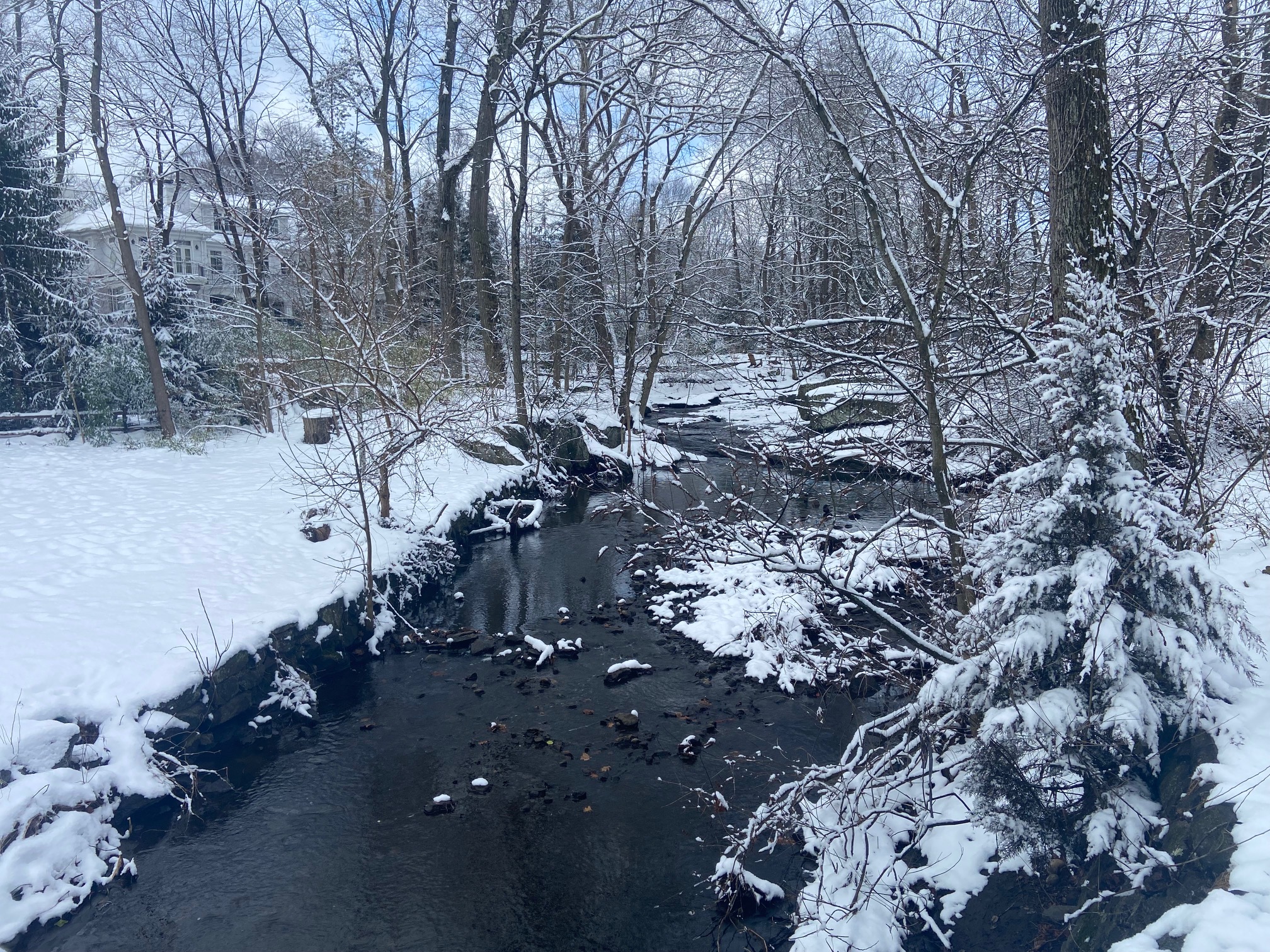
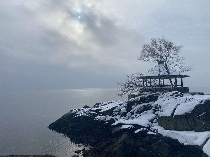
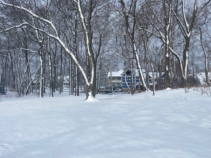
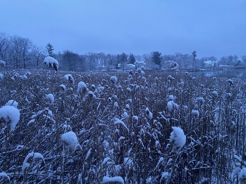
Some photos from this morning. About 2.5" in Larchmont. Although this is not as much as areas to the south, the snow is still beautiful and much treasured on account of its scarcity in recent years.
-
Both of Allentown’s Airports are now reporting light snow just after 11 pm.
-
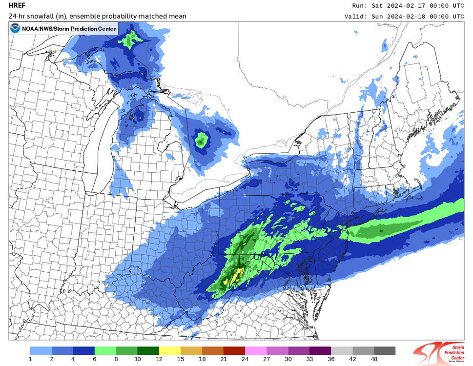
The 0z HREF: I suspect that it is somewhat overdone, but we'll find out tomorrow morning.
-
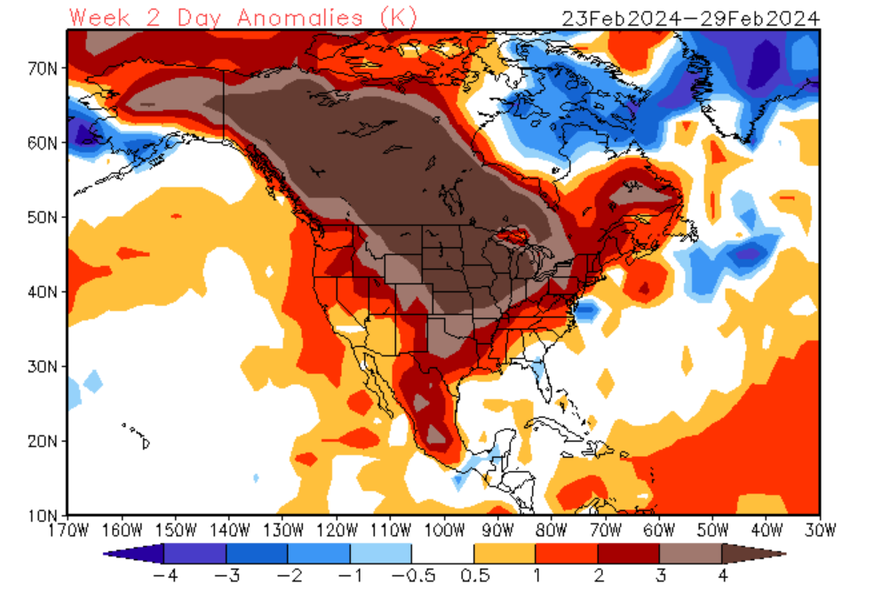
A cooler pattern remains in place. This will not be an especially cold pattern, but it will be noticeably colder than the pattern that defined the first 10 days of the month. A fast-moving clipper system will bring a light to moderate snowfall to parts of the region late tonight into tomorrow ahead of another shot of cooler but not severely cold air. There will likely be general area of 2"-4" snowfall from New York City southward to Washington, DC. Within that area, a stripe of 3"-6" snowfall is possible, particularly in such cities as Baltimore, Philadelphia, and Wilmington. White Plains north and westward will likely see 1"-3" with amounts quickly falling off toward I-84. Snowfall ratios will generally be in the 12:1 to 15:1 range leading to a fluffier snow than during recent events. By next week, milder weather will likely begin to overspread the region. The potential exists for the closing days of February to wind up much warmer than normal. The ENSO Region 1+2 anomaly was +1.2°C and the Region 3.4 anomaly was +1.7°C for the week centered around February 7. For the past six weeks, the ENSO Region 1+2 anomaly has averaged +0.93°C and the ENSO Region 3.4 anomaly has averaged +1.62°C. A basinwide El Niño event is ongoing. The ongoing El Niño event will continue to fade through much of February. The SOI was -3.03 today. The preliminary Arctic Oscillation (AO) was -1.531 today. On February 14 the MJO was in Phase 7 at an amplitude of 1.990 (RMM). The February 13-adjusted amplitude was 1.826 (RMM). Based on sensitivity analysis applied to the latest guidance, there is an implied 88% probability that New York City will have a warmer than normal February (1991-2020 normal). February will likely finish with a mean temperature near 38.8° (2.9° above normal). Winter 2023-2024 is on course to finish with a seasonal mean temperature of 39.9°-40.5°. That would rank the current winter among the ten warmest on record in New York City. It would also mark the second time when two consecutive winters have ranked among the top ten in terms of warmth. Winters 2015-2016 and 2016-2017 are currently the only two such winters to rank among the ten warmest on record. The probability that Winter 2023-2024 will have a mean temperature of 40.0° or above has increased in recent days. Should Winter 2023-2024 finish with a mean temperature of 40.0° or above, that would be the first time on record that New York City has seen two consecutive winters with such warmth.
-
In addition, today's guidance is a bit more aggressive with the clipper.
-
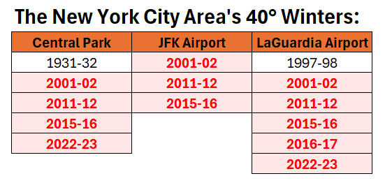
Its low temperature is 14°. If that holds, it would be the warmest such minimum temperature on record. The record of 13° was set during Winter 2001-02. 2019-20 had a winter minimum reading of 12°. The winter mean temperature through February 15th is 36.9°, which is tied with 2022-23 for 4th highest through February 15th. The warmest winter was 2001-02 with a mean temperature of 37.9°. The current winter will become the seventh winter with a mean temperature of 36° or above. Six of those winters will have occurred since 2000. Winter 1932-33 is the lone exception.
-
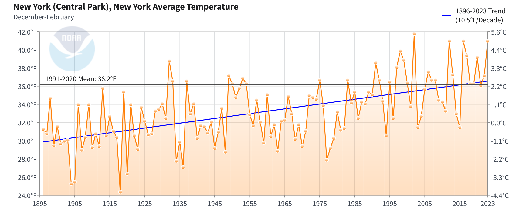
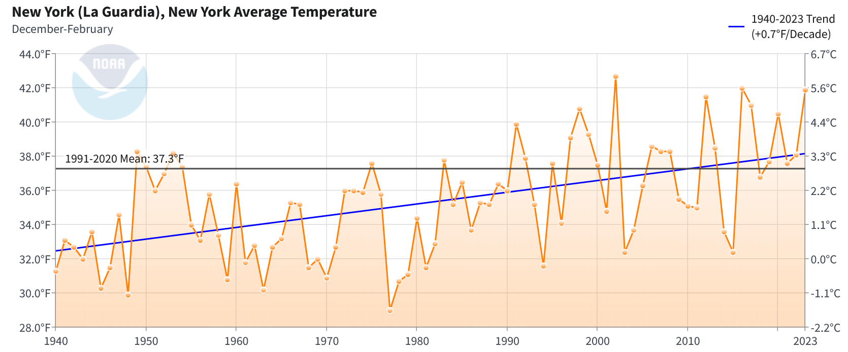
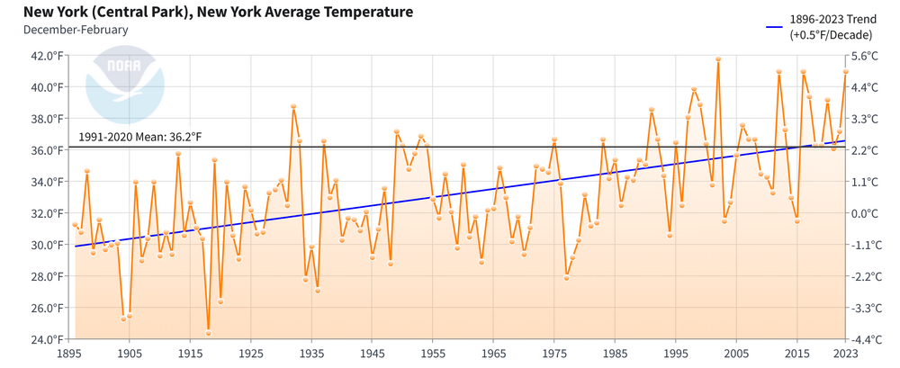
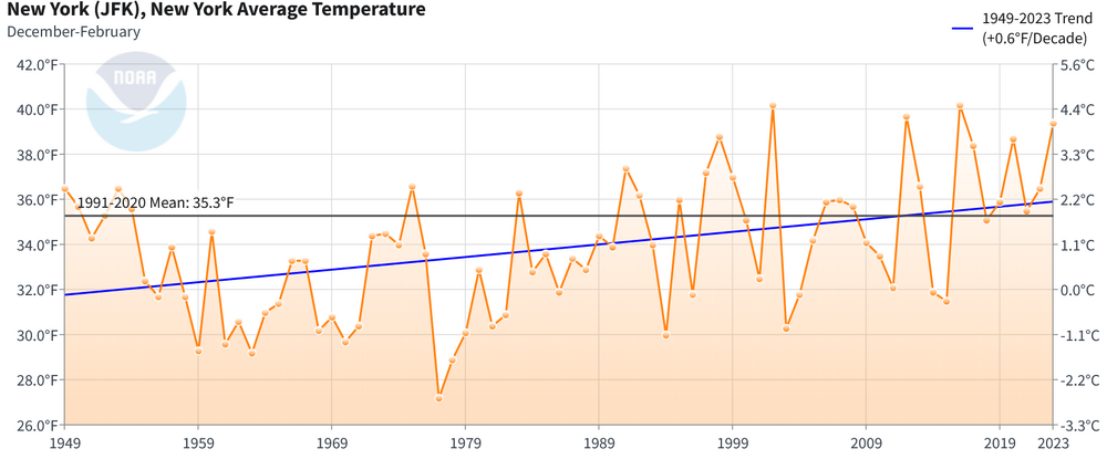
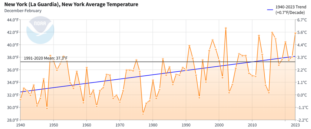
While the region will see light snow late tonight into early tomorrow and a brief shot of colder but not exceptionally cold air, Central Park remains on course for its case with two consecutive winters with an average temperature of 40° or above. The closest such two-winter period was 2015-16 (41.0°) and 2016-17 (39.3°). LaGuardia Airport actually had winter mean temperatures of 40° or above in both those winters. Central Park's period of record goes back to 1869. 40° or above winters are largely a recent phenomenon in the New York City area and the region's winter temperature has been warming. The periods of record for the above stations begin as follows: Central Park: January 1869; JFK Airport: July 1948; and, LaGuardia Airport: October 1939. Previously, the CFSv2 and ECMWF weekly guidance were in strong agreement that a colder, but not severely cold pattern would continue into at least the first week of March. However, as the month advanced, that support on the guidance collapsed and a late February warmup more consistent with strong El Niño winters gained support. The latest weekly guidance shows a very mild close to the month, which makes a 40° or above winter average temperature likely at Central Park and LaGuardia Airport. Both the 2/16 0z EPS and GEFS show February ending with high temperatures of 50° or above. ECMWF Weekly Forecast: CFSv2: All three locations are experiencing a sustained warming of winters: Central Park: JFK Airport: LaGuardia Airport: As the warming continues, 30-year mean winter temperatures will likely cross the 37° threshold at which Mid-Atlantic locations south of the New York City area experienced a long-term decline in seasonal snowfall. Through Winter 2022-23, the 30-year average winter temperature in Central Park had reached 36.2°. Following Winter 2023-24, that figure will likely stand at 36.5°. The climate models suggest that New York City will reach the 37° winter temperature average by the middle 2030s. That would result in 30-year seasonal snowfall declining to around 20". The very recent low snowfall winters are likely a combination of a bad cycle within internal variability and consequence of growing background warming. Therefore, it is possible that New York City is in the very early stages of a transition toward a lower snowfall state. Even in a lower snowfall state, there will still be snowy winters, but those winters will become less frequent. Winters lacking much snowfall (10" or below) will grow more frequent. As for this winter, it remains to be seen whether Central Park will record its first case of two consecutive winters with less than 10" of snowfall. Many strong El Niño winters have seen at least some measurable snowfall in March. Since 1950, there were three that did not: 1966, 1983, and 2020. 1983 had measurable snowfall in April.

-
Some snow flurries are falling in Larchmont.
-
A cooler pattern is now in place. This will not be an especially cold pattern, but it will be noticeably colder than the pattern that defined the first 10 days of the month. A few snow showers are possible during the first half of tonight. Some areas could pick up a dusting outside of the City. Afterward, tomorrow will be fair and seasonably cold. Another system could bring a light snowfall to parts of the late Friday night into Saturday ahead of another shot of cooler but not severely cold air. There will likely be an area of 2"-4" snowfall from central New Jersey southward to Baltimore with some locally higher amounts. New York City could see 1"-2" with perhaps some 3" amounts across Staten Island, southern Queens and southern Brooklyn. By next week, milder weather will likely begin to overspread the region. The potential exists for the closing days of February to wind up much warmer than normal. The ENSO Region 1+2 anomaly was +1.2°C and the Region 3.4 anomaly was +1.7°C for the week centered around February 7. For the past six weeks, the ENSO Region 1+2 anomaly has averaged +0.93°C and the ENSO Region 3.4 anomaly has averaged +1.62°C. A basinwide El Niño event is ongoing. The ongoing El Niño event will continue to fade through much of February. The SOI was -8.55 today. The preliminary Arctic Oscillation (AO) was -2.376 today. On February 13 the MJO was in Phase 7 at an amplitude of 1.826 (RMM). The February 12-adjusted amplitude was 1.859 (RMM). Based on sensitivity analysis applied to the latest guidance, there is an implied 86% probability that New York City will have a warmer than normal February (1991-2020 normal). February will likely finish with a mean temperature near 38.5° (2.6° above normal). Winter 2023-2024 is on course to finish with a seasonal mean temperature of 39.8°-40.5°. That would rank the current winter among the ten warmest on record in New York City. It would also mark the second time when two consecutive winters have ranked among the top ten in terms of warmth. Winters 2015-2016 and 2016-2017 are currently the only two such winters to rank among the ten warmest on record. The probability that Winter 2023-2024 will have a mean temperature of 40.0° or above has increased in recent days. Should Winter 2023-2024 finish with a mean temperature of 40.0° or above, that would be the first time on record that New York City has seen two consecutive winters with such warmth.
-
A cooler pattern is now in place. This will not be an especially cold pattern, but it will be noticeably colder than the pattern that defined the first 10 days of the month. The week will remain dry through Friday aside from a possible shower of rain or snow tomorrow. A system could bring a light snowfall to parts of the region on Saturday ahead of another shot of cooler but not severely cold air. By next week, milder weather will likely begin to overspread the region. The potential exists for the closing days of February to wind up much warmer than normal. The ENSO Region 1+2 anomaly was +1.2°C and the Region 3.4 anomaly was +1.7°C for the week centered around February 7. For the past six weeks, the ENSO Region 1+2 anomaly has averaged +0.93°C and the ENSO Region 3.4 anomaly has averaged +1.62°C. A basinwide El Niño event is ongoing. The ongoing El Niño event will continue to fade through much of February. The SOI was -19.84 today. The preliminary Arctic Oscillation (AO) was -2.376 today. On February 12 the MJO was in Phase 7 at an amplitude of 1.859 (RMM). The February 11-adjusted amplitude was 1.892 (RMM). Based on sensitivity analysis applied to the latest guidance, there is an implied 84% probability that New York City will have a warmer than normal February (1991-2020 normal). February will likely finish with a mean temperature near 38.3° (2.4° above normal). Winter 2023-2024 is on course to finish with a seasonal mean temperature of 39.8°-40.4°. That would rank the current winter among the ten warmest on record in New York City. It would also mark the second time when two consecutive winters have ranked among the top ten in terms of warmth. Winters 2015-2016 and 2016-2017 are currently the only two such winters to rank among the ten warmest on record. The probability that Winter 2023-2024 will have a mean temperature of 40.0° or above has increased in recent days. Should Winter 2023-2024 finish with a mean temperature of 40.0° or above, that would be the first time on record that New York City has seen two consecutive winters with such warmth.
-
1954-55 was a La Niña.
-
No. 1949-50 and 1954-55 were La Niña winters, 1950-51 and 1952-53 were neutral winters, and 1951-52 and 1953-54 were El Niño winters.
-
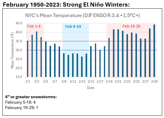
The chart is a quick sketch to illustrate how past strong El Niño events have evolved. No dates reach a threshold of 90% confidence (all 1950-2023 data). It can still alert one to look for possibilities, but isn’t a concrete forecast nor intended to be one. With the likely mild pattern to end February, some might conclude that winter has ended early. Yet, the ENSO data, among other data, can suggest a measure of caution. For example, the ENSO cases were more than twice as likely as all other cases to be 1 sigma or more below normal for March 22. That doesn’t mean that it will be cold. It just means that one cannot prematurely assume that an early spring is assured. Many other variables ultimately determine the outcome. That applies far beyond ENSO e.g., the MJO has an overall coefficient of determination to temperature anomalies well below 0.2. Thus, outcomes for Phase 8 (high amplitude) vary widely even as cases cluster toward a given outcome. One can get some insight but is constrained by the recognition that other outcomes are possible.
-
It was a little worse than I had expected. I thought Central Park would have about 4” when it reported its final figure.
-
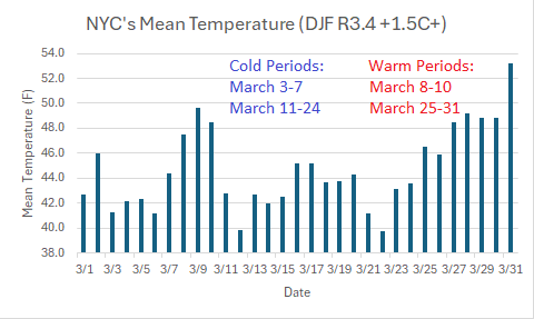
Looking ahead, here are the NYC daily temperature averages from strong El Niño winters:
-
It would take more than 5 more years to reach that mark: 2,572 days (March 1, 1949 through March 15, 1956).
-
I agree. The numbers out there appear realistic and in line with one another.