

donsutherland1
-
Posts
22,982 -
Joined
Content Type
Profiles
Blogs
Forums
American Weather
Media Demo
Store
Gallery
Everything posted by donsutherland1
-
Two Mdt to high impact events NYC subforum; wknd Jan 6-7 Incl OBS, and mid week Jan 9-10 (incl OBS). Total water equiv by 00z/11 general 2", possibly 6" includes snow-ice mainly interior. RVR flood potential increases Jan 10 and beyond. Damaging wind.
donsutherland1 replied to wdrag's topic in New York City Metro
Light rain/snow mix now being reported on Newark's observations.- 3,610 replies
-
- 1
-

-
- snow
- heavy rain
- (and 5 more)
-
Two Mdt to high impact events NYC subforum; wknd Jan 6-7 Incl OBS, and mid week Jan 9-10 (incl OBS). Total water equiv by 00z/11 general 2", possibly 6" includes snow-ice mainly interior. RVR flood potential increases Jan 10 and beyond. Damaging wind.
donsutherland1 replied to wdrag's topic in New York City Metro
1/6-7/2024 Storm: The first snowflakes have reached the general Newark and Clifton areas. Some flurries should be spreading north and eastward across the Hudson River in the next hour or so. Belmar, NJ is reporting light rain. Wilmington, DE has switched to light rain. The colder ECMWF appears not to be verifying there, as little or no accumulation has occurred prior to the precipitation transition. Allentown is receiving light snow, but the observation shows "sky obscured." 1/9-10/2024 Storm: The model guidance remains very impressive with a general 2"-3" of precipitation with locally higher amounts, mild temperatures, and strong winds. River and coastal flooding, along with significant beach erosion, are likely from what should be a high-impact storm.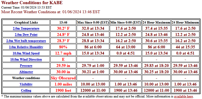
- 3,610 replies
-
- 3
-
-

-
- snow
- heavy rain
- (and 5 more)
-
Two Mdt to high impact events NYC subforum; wknd Jan 6-7 Incl OBS, and mid week Jan 9-10 (incl OBS). Total water equiv by 00z/11 general 2", possibly 6" includes snow-ice mainly interior. RVR flood potential increases Jan 10 and beyond. Damaging wind.
donsutherland1 replied to wdrag's topic in New York City Metro
Aside from the maps having 10:1 ratios (more likely to be 5:1 in and around the NYC Metro Area), it is falling short in upstream areas where precipitation has been falling. For example, Sterling (IAD) has gone over to light rain after little or no accumulation. Later data from Wilmington, DE and Philadelphia will provide greater insight as to how things are working e.g., the snowfall amounts on the southern and eastern fringes of the measurable snowfall might be too high.- 3,610 replies
-
- 3
-
-
- snow
- heavy rain
- (and 5 more)
-
Two Mdt to high impact events NYC subforum; wknd Jan 6-7 Incl OBS, and mid week Jan 9-10 (incl OBS). Total water equiv by 00z/11 general 2", possibly 6" includes snow-ice mainly interior. RVR flood potential increases Jan 10 and beyond. Damaging wind.
donsutherland1 replied to wdrag's topic in New York City Metro
As per mPing, light snow has reached Allentown and Easton.- 3,610 replies
-
- 1
-
-
- snow
- heavy rain
- (and 5 more)
-
Two Mdt to high impact events NYC subforum; wknd Jan 6-7 Incl OBS, and mid week Jan 9-10 (incl OBS). Total water equiv by 00z/11 general 2", possibly 6" includes snow-ice mainly interior. RVR flood potential increases Jan 10 and beyond. Damaging wind.
donsutherland1 replied to wdrag's topic in New York City Metro
It's amazing how detailed they have become. It will be interesting to see the gradient from little snowfall to moderate or greater snowfall. -
Two Mdt to high impact events NYC subforum; wknd Jan 6-7 Incl OBS, and mid week Jan 9-10 (incl OBS). Total water equiv by 00z/11 general 2", possibly 6" includes snow-ice mainly interior. RVR flood potential increases Jan 10 and beyond. Damaging wind.
donsutherland1 replied to wdrag's topic in New York City Metro
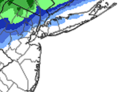
Latest HREF: The 1" line appears to be near the border of Manhattan and the Bronx, but north of Central Park: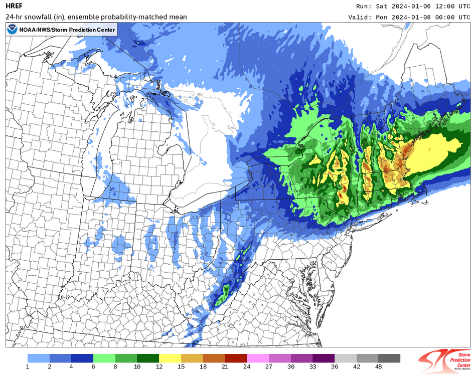
-
Two Mdt to high impact events NYC subforum; wknd Jan 6-7 Incl OBS, and mid week Jan 9-10 (incl OBS). Total water equiv by 00z/11 general 2", possibly 6" includes snow-ice mainly interior. RVR flood potential increases Jan 10 and beyond. Damaging wind.
donsutherland1 replied to wdrag's topic in New York City Metro
As per the 5-minute observations, PHL started seeing light snow at 11:11 am. Visibility was 10 miles, so it’s probably flurries. -
Two Mdt to high impact events NYC subforum; wknd Jan 6-7 Incl OBS, and mid week Jan 9-10 (incl OBS). Total water equiv by 00z/11 general 2", possibly 6" includes snow-ice mainly interior. RVR flood potential increases Jan 10 and beyond. Damaging wind.
donsutherland1 replied to wdrag's topic in New York City Metro
1/6-7/2024 Storm: Light snow has reached Philadelphia. Wilmington, DE is also seeing light snow.- 3,610 replies
-
- 1
-
-
- snow
- heavy rain
- (and 5 more)
-
Two Mdt to high impact events NYC subforum; wknd Jan 6-7 Incl OBS, and mid week Jan 9-10 (incl OBS). Total water equiv by 00z/11 general 2", possibly 6" includes snow-ice mainly interior. RVR flood potential increases Jan 10 and beyond. Damaging wind.
donsutherland1 replied to wdrag's topic in New York City Metro
Latest Winter Storm Severity Index: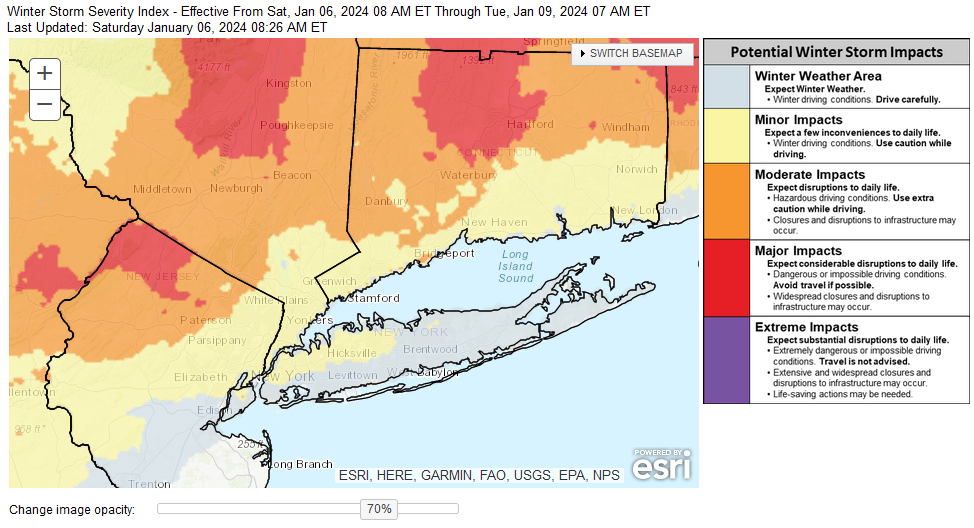
-
Two Mdt to high impact events NYC subforum; wknd Jan 6-7 Incl OBS, and mid week Jan 9-10 (incl OBS). Total water equiv by 00z/11 general 2", possibly 6" includes snow-ice mainly interior. RVR flood potential increases Jan 10 and beyond. Damaging wind.
donsutherland1 replied to wdrag's topic in New York City Metro
Latest EPS and NBE numbers: As the EPS is based on 10:1 ratios, those figures should probably be cut in half given the low ratio snow that is likely due to above freezing temperatures. For example, the high probability of 1" or more snowfall should be read as showing a high probability of measurable snowfall. Wet snow should fall for a time in NYC, but the opportunity for accumulation will likely be limited to periods where it falls moderately. My guess is that a slushy inch remains likely in Central Park.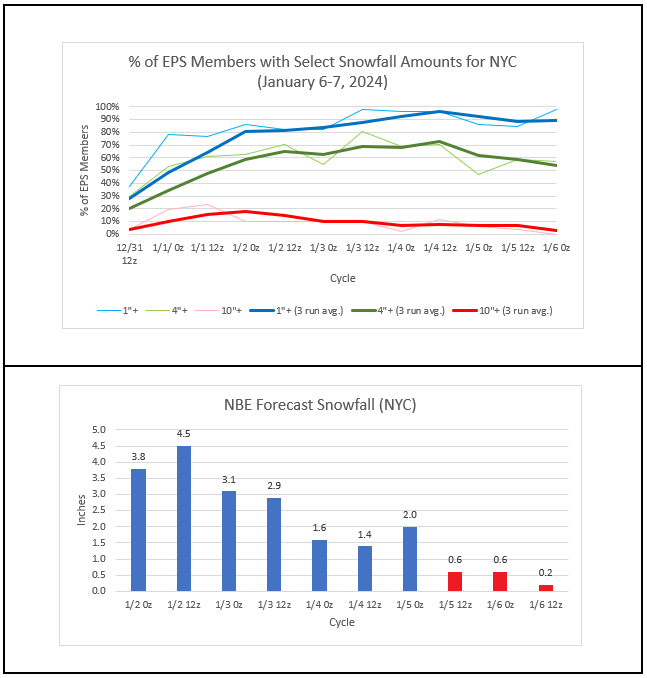
-
Two Mdt to high impact events NYC subforum; wknd Jan 6-7 Incl OBS, and mid week Jan 9-10 (incl OBS). Total water equiv by 00z/11 general 2", possibly 6" includes snow-ice mainly interior. RVR flood potential increases Jan 10 and beyond. Damaging wind.
donsutherland1 replied to wdrag's topic in New York City Metro
EPS and NBE information. Note: EPS data is based on 10:1 ratios. Actual ratios will be much lower given the above freezing temperatures during the storm. My guess is that Central Park will likely see a slushy inch of snow while lower Manhattan, Queens, Brooklyn, and Staten Island see a coating. There is still room for minor changes. I remain concerned about the combination of warm soundings and above freezing temperatures.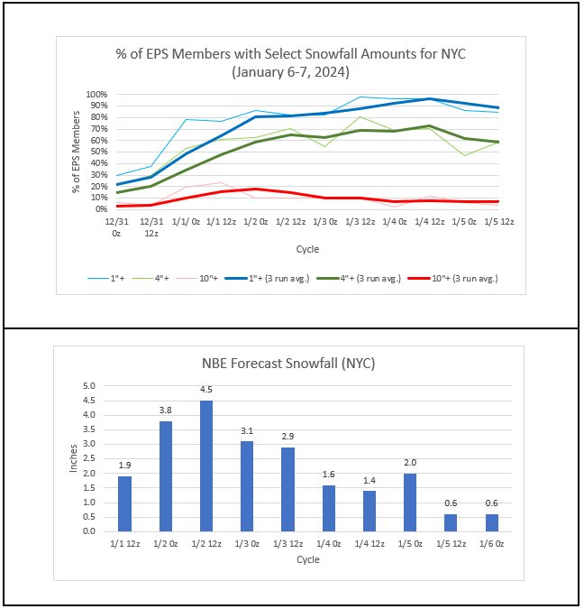
- 3,610 replies
-
- 1
-
-
- snow
- heavy rain
- (and 5 more)
-
The period of quiet weather is coming to an end. The region will be impacted by a series of storms over the next seven days. Tomorrow will be increasingly cloudy and cold. Snow and/or mixed precipitation will overspread the region during the afternoon into the evening. Precipitation will quickly become all rain along the coast. Precipitation will end on Sunday possibly as light snow or snow showers. The storm will likely bring a coating to Queens, Brooklyn, and Staten Island, a slushy inch to Central Park, and up to 2" in the Bronx. 3"-6" of snow will fall well north and west of New York City. Following the region's first winter storm, a severe storm could bring a heavy windswept rain to much of the region during the middle of next week. The potential exists for a 1"-3" rainfall with locally higher amounts, damaging winds, and possibly significant coastal flooding. Temperatures could surge toward or into the 50s. Late next week, a genuine Arctic air mass will likely begin pushing into the Pacific Northwest and Northern Plains. Severe cold is likely in the affected region. Afterward, this cold air could try to come eastward. The ENSO Region 1+2 anomaly was +0.8°C and the Region 3.4 anomaly was +2.0°C for the week centered around December 27. For the past six weeks, the ENSO Region 1+2 anomaly has averaged +1.55°C and the ENSO Region 3.4 anomaly has averaged +2.00°C. A basinwide El Niño event is ongoing. The SOI was -6.59 today. The preliminary Arctic Oscillation (AO) was -0.595 today. Strong blocking in the final week of November, as occurred this year, has often been followed by frequent blocking in December and January. On January 3 the MJO was in Phase 2 at an amplitude of 2.301 (RMM). The January 2-adjusted amplitude was 2.276(RMM).
-
Two Mdt to high impact events NYC subforum; wknd Jan 6-7 Incl OBS, and mid week Jan 9-10 (incl OBS). Total water equiv by 00z/11 general 2", possibly 6" includes snow-ice mainly interior. RVR flood potential increases Jan 10 and beyond. Damaging wind.
donsutherland1 replied to wdrag's topic in New York City Metro
For reference:
- 3,610 replies
-
- 1
-
-
- snow
- heavy rain
- (and 5 more)
-
Two Mdt to high impact events NYC subforum; wknd Jan 6-7 Incl OBS, and mid week Jan 9-10 (incl OBS). Total water equiv by 00z/11 general 2", possibly 6" includes snow-ice mainly interior. RVR flood potential increases Jan 10 and beyond. Damaging wind.
donsutherland1 replied to wdrag's topic in New York City Metro
The text also showed 0.0C at 925 mb.- 3,610 replies
-
- 1
-
-
- snow
- heavy rain
- (and 5 more)
-
-
Two Mdt to high impact events NYC subforum; wknd Jan 6-7 Incl OBS, and mid week Jan 9-10 (incl OBS). Total water equiv by 00z/11 general 2", possibly 6" includes snow-ice mainly interior. RVR flood potential increases Jan 10 and beyond. Damaging wind.
donsutherland1 replied to wdrag's topic in New York City Metro
3"6" for the northern half of Westchester (most a higher elevations). -
Two Mdt to high impact events NYC subforum; wknd Jan 6-7 Incl OBS, and mid week Jan 9-10 (incl OBS). Total water equiv by 00z/11 general 2", possibly 6" includes snow-ice mainly interior. RVR flood potential increases Jan 10 and beyond. Damaging wind.
donsutherland1 replied to wdrag's topic in New York City Metro
Probably 3”-5” (more at higher elevations).- 3,610 replies
-
- 2
-
-
- snow
- heavy rain
- (and 5 more)
-
Two Mdt to high impact events NYC subforum; wknd Jan 6-7 Incl OBS, and mid week Jan 9-10 (incl OBS). Total water equiv by 00z/11 general 2", possibly 6" includes snow-ice mainly interior. RVR flood potential increases Jan 10 and beyond. Damaging wind.
donsutherland1 replied to wdrag's topic in New York City Metro
Hopefully, that scenario will play out. -
Two Mdt to high impact events NYC subforum; wknd Jan 6-7 Incl OBS, and mid week Jan 9-10 (incl OBS). Total water equiv by 00z/11 general 2", possibly 6" includes snow-ice mainly interior. RVR flood potential increases Jan 10 and beyond. Damaging wind.
donsutherland1 replied to wdrag's topic in New York City Metro
I don’t know how the maps are programmed. -
Two Mdt to high impact events NYC subforum; wknd Jan 6-7 Incl OBS, and mid week Jan 9-10 (incl OBS). Total water equiv by 00z/11 general 2", possibly 6" includes snow-ice mainly interior. RVR flood potential increases Jan 10 and beyond. Damaging wind.
donsutherland1 replied to wdrag's topic in New York City Metro
The GFS shows snow at HPN until near 42 hours. Then, there's at least some sleet mixing in. Surface temperatures are above freezing, though.- 3,610 replies
-
- 2
-
-
- snow
- heavy rain
- (and 5 more)
-
Two Mdt to high impact events NYC subforum; wknd Jan 6-7 Incl OBS, and mid week Jan 9-10 (incl OBS). Total water equiv by 00z/11 general 2", possibly 6" includes snow-ice mainly interior. RVR flood potential increases Jan 10 and beyond. Damaging wind.
donsutherland1 replied to wdrag's topic in New York City Metro
Reminder: Avoid 10:1 Snow Maps. Go to the Soundings. Latest illustration: 12z GFS at 36 hours. The maps show moderate to heavy snow at JFK. The sounding supports rain. The column is above freezing until one reaches 925 mb. The surface temperature is 38°. Based on the soundings, JFK has little or no accumulation of snow rather than the amounts shown on the 10:1 maps. I highlighted the 0°C line for ease of viewing.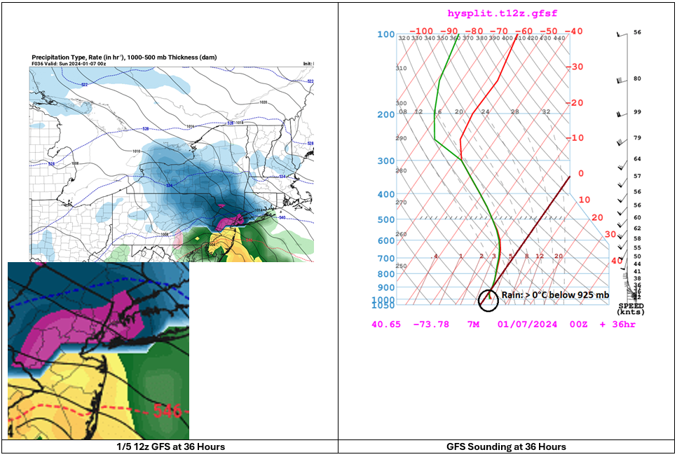
- 3,610 replies
-
- 7
-
-
-
- snow
- heavy rain
- (and 5 more)
-
Two Mdt to high impact events NYC subforum; wknd Jan 6-7 Incl OBS, and mid week Jan 9-10 (incl OBS). Total water equiv by 00z/11 general 2", possibly 6" includes snow-ice mainly interior. RVR flood potential increases Jan 10 and beyond. Damaging wind.
donsutherland1 replied to wdrag's topic in New York City Metro
HREF through 1/7 12z: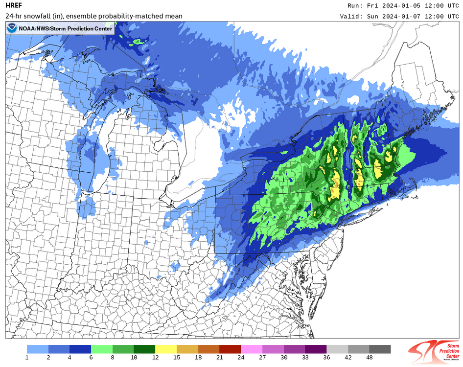
- 3,610 replies
-
- 2
-
-
- snow
- heavy rain
- (and 5 more)
-
Two Mdt to high impact events NYC subforum; wknd Jan 6-7 Incl OBS, and mid week Jan 9-10 (incl OBS). Total water equiv by 00z/11 general 2", possibly 6" includes snow-ice mainly interior. RVR flood potential increases Jan 10 and beyond. Damaging wind.
donsutherland1 replied to wdrag's topic in New York City Metro
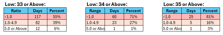
Distribution of Daily Snowfall Amounts by Minimum Temperature with Total Precipitation of 0.50" or More and Measurable Snowfall: Distribution of Event Average Snow-to-Liquid Ratios: The mean event average snow-to-liquid ratio was 1.4 (standard deviation: 1.5). The lowest was near 0. The highest was 9.2. This data was taken from the combined climate records for Bridgeport, Islip, New York City, Newark, and Philadelphia. At present, it appears that Central Park's low temperature during the precipitation will likely be 34° or above. NAM and GFS MOS: 34°. NBE: 36° +/- 3°. This historic data also argues for a low ratio and light accumulation of snow for New York City.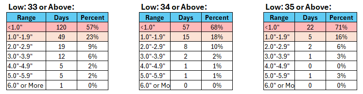
-
Two Mdt to high impact events NYC subforum; wknd Jan 6-7 Incl OBS, and mid week Jan 9-10 (incl OBS). Total water equiv by 00z/11 general 2", possibly 6" includes snow-ice mainly interior. RVR flood potential increases Jan 10 and beyond. Damaging wind.
donsutherland1 replied to wdrag's topic in New York City Metro
National Blend of Models Output (0z and 12z cycles): The 1/5 14z run decreased a little more to 0.5". It shows a minimum temperature of 36° during the precipitation. Any snow that falls in the NYC area will be low- to very low-ratio snow.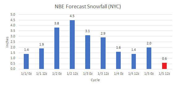
- 3,610 replies
-
- 1
-
-
- snow
- heavy rain
- (and 5 more)
-
Two Mdt to high impact events NYC subforum; wknd Jan 6-7 Incl OBS, and mid week Jan 9-10 (incl OBS). Total water equiv by 00z/11 general 2", possibly 6" includes snow-ice mainly interior. RVR flood potential increases Jan 10 and beyond. Damaging wind.
donsutherland1 replied to wdrag's topic in New York City Metro
In the past, I used to ignore it. But the problem has become so widespread that I now call them out. It's unfortunate, as it really takes time that I'd prefer to be doing some other things.- 3,610 replies
-
- 3
-
-
- snow
- heavy rain
- (and 5 more)

