donsutherland1
-
Posts
23,765 -
Joined
Content Type
Profiles
Blogs
Forums
American Weather
Media Demo
Store
Gallery
Everything posted by donsutherland1
-
A long stretch of above to much above normal temperatures is now underway. That temperature regime will likely persist through much of the remainder of June. A brief push of cooler air is possible toward the end of the month. New York City reached 90° for the first time this season. Baltimore, Newark, Philadelphia, and Washington, DC are currently experiencing heatwaves. Following New York City's 4th warmest spring and Philadelphia's 6th warmest spring, it is very likely that June 2024 will rank among the 10 warmest Junes on record in both cities. Records go back to 1869 in New York City and 1874 in Philadelphia. The latest summer guidance continues to suggest a warmer to much warmer than normal summer lies ahead. The ENSO Region 1+2 anomaly was -0.6°C and the Region 3.4 anomaly was 0.0°C for the week centered around June 12. For the past six weeks, the ENSO Region 1+2 anomaly has averaged -0.80°C and the ENSO Region 3.4 anomaly has averaged +0.15°C. Neutral ENSO conditions will likely evolve into a La Niña event during the late summer or early fall. The SOI was -13.01 yesterday. The preliminary Arctic Oscillation (AO) was +0.795 today. Based on sensitivity analysis applied to the latest guidance, there is an implied 99% probability that New York City will have a warmer than normal June (1991-2020 normal). June will likely finish with a mean temperature near 75.7° (3.7° above normal). That would make June 2024 the second warmest June on record.
-
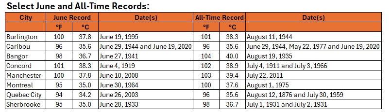
Some records for today: · Bathurst, NB: 100F/37.6C (new provincial June high temperature record) · Boston: 98F/36.7C (tied 6th highest June temperature on record) · Caribou, ME: 96F/35.6C (tied all-time record high) · Causapscal, QC: 97F/36.0C (new all-time record high) · Miramichi, NB: 99F/37.2C (tied highest June temperature on record) · North Cape, PE: 95F/34.9C (new all-time record and June provincial record) · Seboeis River near Shin Pond 5 NW, ME: 100F/37.8C (tied state monthly record for June) Burlington (80) and Caribou (71) remain on track to match their all-time record highest minimum temperatures.
-
A long stretch of above to much above normal temperatures is now underway. Newark and Washington, DC have now reached heatwave status. Parts of Upstate New York, northern New England and Quebec experienced record heat today. Records included: Albany: 94° (tied record set in 1995) Bangor: 95° (tied record set in 1995) Boston: 98° (old record: 96°, 1923) Caribou: 96° (tied record set in 2020) ***Tied all-time record*** Manchester: 98° (old record: 96°, 1941) Montreal: 92°/33.5°C (old record: 92°/33.1°C, 2001) Quebec City: 92°/33.4°C (old record: 92°/33.2°C, 2020) In addition, Bathurst, NB reached 100° (37.6°C). That set a new provincial record for June. The preliminary lows of 71° at Caribou and 80° at Burlington tied those cities' all-time record highest minimum temperatures. Following New York City's 4th warmest spring and Philadelphia's 6th warmest spring, it is very likely that June 2024 will rank among the 10 warmest Junes on record in both cities. Records go back to 1869 in New York City and 1874 in Philadelphia. Philadelphia will likely reach heatwave status tomorrow. There is a possibility that Philadelphia could go on to experience its longest June heatwave on record. The existing record is 7 days. That record was set during June 1-7, 1925 and tied during June 13-19, 1957. Philadelphia's records go back to December 1873. The latest summer guidance continues to suggest a warmer to much warmer than normal summer lies ahead. The ENSO Region 1+2 anomaly was -0.6°C and the Region 3.4 anomaly was 0.0°C for the week centered around June 12. For the past six weeks, the ENSO Region 1+2 anomaly has averaged -0.80°C and the ENSO Region 3.4 anomaly has averaged +0.15°C. Neutral ENSO conditions will likely evolve into a La Niña event during the late summer or early fall. The SOI was -13.01 today. The preliminary Arctic Oscillation (AO) was -0.021 today. Based on sensitivity analysis applied to the latest guidance, there is an implied 98% probability that New York City will have a warmer than normal June (1991-2020 normal). June will likely finish with a mean temperature near 75.7° (3.7° above normal). That would make June 2024 the second warmest June on record.
-
Several quick highlights: - Newark now has a heatwave - Caribou has tied its all-time record high of 96 - Burlington and Caribou are on track to tie their all-time record high minimum temperature
-
In addition, the 71° low temperature would set a new June mark and tie the all-time record.
-
A long stretch of above to much above normal temperatures is now underway. Parts of the region could experience their first heatwave of the summer this week. Newark should reach heatwave status tomorrow. The most anomalous heat will affect the Great Lakes region, Upstate New York, southern Canada, and northern New England. The potential exists for Burlington to make a run at 100° at the height of the heat and Caribou to approach or reach 96°. Following New York City's 4th warmest spring and Philadelphia's 6th warmest spring, it is very likely that June 2024 will rank among the 10 warmest Junes on record in both cities. Records go back to 1869 in New York City and 1874 in Philadelphia. The latest summer guidance continues to suggest a warmer to much warmer than normal summer lies ahead. The ENSO Region 1+2 anomaly was -0.6°C and the Region 3.4 anomaly was 0.0°C for the week centered around June 12. For the past six weeks, the ENSO Region 1+2 anomaly has averaged -0.80°C and the ENSO Region 3.4 anomaly has averaged +0.15°C. Neutral ENSO conditions will likely evolve into a La Niña event during the late summer or early fall. The SOI was +0.07 today. The preliminary Arctic Oscillation (AO) was -0.933 today. Based on sensitivity analysis applied to the latest guidance, there is an implied 95% probability that New York City will have a warmer than normal June (1991-2020 normal). June will likely finish with a mean temperature near 75.5° (3.5° above normal). That would make June 2024 the second warmest June on record.
-
A long stretch of above to much above normal temperatures is now developing. Parts of the region could experience their first heatwave of the summer this week. The most anomalous heat will affect the Great Lakes region, Upstate New York, southern Canada, and northern New England. The potential exists for Burlington to make a run at 100° at the height of the heat and Caribou to approach or reach 96°. Following New York City's 4th warmest spring and Philadelphia's 6th warmest spring, it is very likely that June 2024 will rank among the 10 warmest Junes on record in both cities. Records go back to 1869 in New York City and 1874 in Philadelphia. The latest summer guidance continues to suggest a warmer to much warmer than normal summer lies ahead. The ENSO Region 1+2 anomaly was -0.6°C and the Region 3.4 anomaly was 0.0°C for the week centered around June 12. For the past six weeks, the ENSO Region 1+2 anomaly has averaged -0.80°C and the ENSO Region 3.4 anomaly has averaged +0.15°C. Neutral ENSO conditions will likely evolve into a La Niña event during the late summer or early fall. The preliminary Arctic Oscillation (AO) was -1.155 today. Based on sensitivity analysis applied to the latest guidance, there is an implied 94% probability that New York City will have a warmer than normal June (1991-2020 normal). June will likely finish with a mean temperature near 75.5° (3.5° above normal). That would make June 2024 the second warmest June on record.
-
The heat will begin to build tomorrow and a long stretch of above to much above normal temperatures will develop. Parts of the region could experience their first heatwave of the summer this week. The most anomalous heat will affect the Great Lakes region, Upstate New York, southern Canada, and northern New England. The potential exists for Burlington to make a run at 100° at the height of the heat and Caribou to approach or reach 96°. Following New York City's 4th warmest spring and Philadelphia's 6th warmest spring, it is very likely that June 2024 will rank among the 10 warmest Junes on record in both cities. Records go back to 1869 in New York City and 1874 in Philadelphia. The latest summer guidance continues to suggest a warmer to much warmer than normal summer lies ahead. The ENSO Region 1+2 anomaly was -0.5°C and the Region 3.4 anomaly was +0.1°C for the week centered around June 5. For the past six weeks, the ENSO Region 1+2 anomaly has averaged -0.57°C and the ENSO Region 3.4 anomaly has averaged +0.23°C. Neutral ENSO conditions will likely evolve into a La Niña event during the late summer or early fall. The SOI was +8.08 yesterday. The preliminary Arctic Oscillation (AO) was -0.842 today. Based on sensitivity analysis applied to the latest guidance, there is an implied 94% probability that New York City will have a warmer than normal June (1991-2020 normal). June will likely finish with a mean temperature near 75.5° (3.5° above normal). That would make June 2024 the second warmest June on record.
-
Tomorrow will end the weekend with abundant sunshine, low humidity, and comfortable temperatures. After staring in the low 60s in New York City and generally 50s outside the the City, the mercury will top out in the middle and upper 70s. Afterward, a long stretch of above to much above normal temperatures will develop. Parts of the region could experience their first heatwave of the summer next week. The most anomalous heat will affect the Great Lakes region, Upstate New York, southern Canada, and northern New England. The potential exists for Burlington to make a run at 100° at the height of the heat and Caribou to approach or reach 96°. Following New York City's 4th warmest spring and Philadelphia's 6th warmest spring, it is very likely that June 2024 will rank among the 10 warmest Junes on record in both cities. Records go back to 1869 in New York City and 1874 in Philadelphia. The latest summer guidance continues to suggest a warmer to much warmer than normal summer lies ahead. The ENSO Region 1+2 anomaly was -0.5°C and the Region 3.4 anomaly was +0.1°C for the week centered around June 5. For the past six weeks, the ENSO Region 1+2 anomaly has averaged -0.57°C and the ENSO Region 3.4 anomaly has averaged +0.23°C. Neutral ENSO conditions will likely evolve into a La Niña event during the late summer or early fall. The SOI was +8.08 today. The preliminary Arctic Oscillation (AO) was -0.264 today. Based on sensitivity analysis applied to the latest guidance, there is an implied 92% probability that New York City will have a warmer than normal June (1991-2020 normal). June will likely finish with a mean temperature near 75.5° (3.5° above normal). That would make June 2024 the second warmest June on record.
-
Following this evening's showers and thunderstorms, a pleasant weekend lies ahead. In New York City, highs will be in the upper 70s and lower 80s tomorrow and the middle and upper 70s on Sunday. Morning lows will be in the lower 60s in the City and 50s outside the City. Afterward, a long stretch of above to much above normal temperatures will develop. Parts of the region could experience their first heatwave of the summer next week. The most anomalous heat will affect the Great Lakes region, Upstate New York, southern Canada, and northern New England. The potential exists for Burlington to make a run at 100° at the height of the heat. Following New York City's 4th warmest spring and Philadelphia's 6th warmest spring, there is a distinct possibility that June 2024 will rank among the 10 warmest Junes on record in both cities. Records go back to 1869 in New York City and 1874 in Philadelphia. The latest summer guidance continues to suggest a warmer to much warmer than normal summer lies ahead. The ENSO Region 1+2 anomaly was -0.5°C and the Region 3.4 anomaly was +0.1°C for the week centered around June 5. For the past six weeks, the ENSO Region 1+2 anomaly has averaged -0.57°C and the ENSO Region 3.4 anomaly has averaged +0.23°C. Neutral ENSO conditions will likely evolve into a La Niña event during the late summer or early fall. The SOI was +4.22 yesterday. The preliminary Arctic Oscillation (AO) was +0.220 today. Based on sensitivity analysis applied to the latest guidance, there is an implied 90% probability that New York City will have a warmer than normal June (1991-2020 normal). June will likely finish with a mean temperature near 75.4° (3.4° above normal). That would tie June 2024 with June 1966 as the second warmest June on record.
-
Occasional Thoughts on Climate Change
donsutherland1 replied to donsutherland1's topic in Climate Change
Yes. I suspect that the 1915-48 period did not provide reliable data for Phoenixville. The site record doesn’t provide sufficient information to know whether the equipment was flawed or its siting was flawed. Fortunately, as you noted, NOAA addresses such issues. -
Occasional Thoughts on Climate Change
donsutherland1 replied to donsutherland1's topic in Climate Change
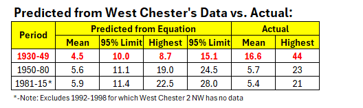
I agree. There is very likely an issue with the earlier Phoenixville numbers for 95F days. To look further into the matter, I ran regression equations based on the 1950-1980 period testing West Chester and Phoenixville and West Chester and Coatesville. The West Chester - Phoenixville equation broke down badly when applied to the 1930-1949 period, ballooning from 2.8 days to 12.4 days. The West Chester - Coatesville equation held reasonably consistent. This disparity suggested that the issue concerned Phoenixville, not West Chester. To determine whether the 1950-1980 period was an issue, I also tested that equation for 1981-2015 for West Chester - Phoenixville. The equation held up reasonably well. The Coatesville data record ended in 1982, so I could not test the West Chester - Coatesville relationship. In sum, the combination of the consistency of the West Chester - Phoenixville equation for the 1950-1980 and 1981-2015 periods and the consistency of the West Chester - Coatesville equations for the 1930-1949 and 1950-80 periods strongly argues that Phoenixville's 1930-1949 measurements were at issue and are not reliable. The Phoenixville station history can be found here: https://www.ncdc.noaa.gov/cdo-web/datasets/GHCND/stations/GHCND:USC00366927/detail and https://www.ncdc.noaa.gov/cdo-web/datasets/GHCND/stations/GHCND:USC00366927/detail In terms of predicted vs. actual 95F days, the 1930-1949 period for Phoenixville was wildly out of line, even vastly exceeding the 95% confidence limit. Considering that the average number of 95F days exceeded the predicted figure for maximum such days during the entire period, it is very likely that the 1930-1949 data for Phoenixville is not reliable. Moreover, based on the predicted values, it is more likely than not that Phoenixville is experiencing an increase in 95F days in line with the other sites.
-
Tomorrow will be very warm with a high in the middle and upper 80s. Some hot spots could reach or exceed 90°. A strong thunderstorm is possible during the afternoon or evening as a cold front crosses the region. Any thunderstorm could contain briefly heavy downpours, gusty winds, and possibly some hail. A pleasant weekend will follow. Afterward, the potential exists for a long stretch of above to much above normal temperatures. Parts of the region could experience their first heatwave of the summer next week. Following New York City's 4th warmest spring and Philadelphia's 6th warmest spring, there is a distinct possibility that June 2024 will rank among the 10 warmest Junes on record in both cities. Records go back to 1869 in New York City and 1874 in Philadelphia. The latest summer guidance continues to suggest a warmer to much warmer than normal summer lies ahead. The ENSO Region 1+2 anomaly was -0.5°C and the Region 3.4 anomaly was +0.1°C for the week centered around June 5. For the past six weeks, the ENSO Region 1+2 anomaly has averaged -0.57°C and the ENSO Region 3.4 anomaly has averaged +0.23°C. Neutral ENSO conditions will likely evolve into a La Niña event during the late summer or early fall. The SOI was +4.22 today. The preliminary Arctic Oscillation (AO) was +0.950 today. Based on sensitivity analysis applied to the latest guidance, there is an implied 87% probability that New York City will have a warmer than normal June (1991-2020 normal). June will likely finish with a mean temperature near 75.2° (3.2° above normal). That would tie June 2024 with June 1994 as the third warmest June on record.
-
Tomorrow and Friday will be very warm days with temperatures rising into the middle and upper 80s. Some hot spots could reach or exceed 90°. A thundershower is possible on Friday as a cold front crosses the region. A pleasnt weekend will follow. Afterward, the potential exists for a long stretch of above to much above normal temperatures. Parts of the region could experience their first heatwave of the summer. Following New York City's 4th warmest spring and Philadelphia's 6th warmest spring, there is a distinct possibility that June 2024 will rank among the 10 warmest Junes on record in both cities. Records go back to 1869 in New York City and 1874 in Philadelphia. The latest summer guidance continues to suggest a warmer to much warmer than normal summer lies ahead. The ENSO Region 1+2 anomaly was -0.5°C and the Region 3.4 anomaly was +0.1°C for the week centered around June 5. For the past six weeks, the ENSO Region 1+2 anomaly has averaged -0.57°C and the ENSO Region 3.4 anomaly has averaged +0.23°C. Neutral ENSO conditions will likely evolve into a La Niña event during the late summer or early fall. The SOI was -6.40 today. The preliminary Arctic Oscillation (AO) was +0.953 today. Based on sensitivity analysis applied to the latest guidance, there is an implied 86% probability that New York City will have a warmer than normal June (1991-2020 normal). June will likely finish with a mean temperature near 75.2° (3.2° above normal).
-
That he's again hinting at cold and pulling the most extreme (even flawed maps) to illustrate his thinking is no longer surprising. It damages what's left of his credibility, but he seems to place clicks above credibility at this stage of his career. He is nowhere close to what he once was at Accuweather.
-
Tomorrow will be a bit warmer with temperatures reaching the upper 70s and lower 80s. A warming trend will commence after midweek. Afterward, following a weekend with near normal temperatures from a brief push of somewhat cooler air, the potential exists for a long stretch of above to much above normal temperatures. Following New York City's 4th warmest spring and Philadelphia's 6th warmest spring, there is a distinct possibility that June 2024 will rank among the 10 warmest Junes on record in both cities. Records go back to 1869 in New York City and 1874 in Philadelphia. The latest summer guidance continues to suggest a warmer to much warmer than normal summer lies ahead. The ENSO Region 1+2 anomaly was -0.5°C and the Region 3.4 anomaly was +0.1°C for the week centered around June 5. For the past six weeks, the ENSO Region 1+2 anomaly has averaged -0.57°C and the ENSO Region 3.4 anomaly has averaged +0.23°C. Neutral ENSO conditions will likely evolve into a La Niña event during the late summer or early fall. The SOI was -11.88 today. The preliminary Arctic Oscillation (AO) was -0.039 today. Based on sensitivity analysis applied to the latest guidance, there is an implied 87% probability that New York City will have a warmer than normal June (1991-2020 normal). June will likely finish with a mean temperature near 75.3° (3.3° above normal).
-
Tomorrow will be another comfortable day with the temperature topping out in the middle and upper 70s in much of the region. Minimum temperatures will again start in the lower 60s in New York City and 50s outside the City. A warming trend will commence after midweek. Afterward, the potential exists for a long stretch of above to much above normal temperatures. Following New York City's 4th warmest spring and Philadelphia's 6th warmest spring, there is a distinct possibility that June 2024 will rank among the 10 warmest Junes on record in both cities. Records go back to 1869 in New York City and 1874 in Philadelphia. The latest summer guidance continues to suggest a warmer to much warmer than normal summer lies ahead. The ENSO Region 1+2 anomaly was -0.5°C and the Region 3.4 anomaly was +0.1°C for the week centered around June 5. For the past six weeks, the ENSO Region 1+2 anomaly has averaged -0.57°C and the ENSO Region 3.4 anomaly has averaged +0.23°C. Neutral ENSO conditions will likely evolve into a La Niña event during the late summer or early fall. The SOI was -19.47 today. The preliminary Arctic Oscillation (AO) was -0.933 today. Based on sensitivity analysis applied to the latest guidance, there is an implied 85% probability that New York City will have a warmer than normal June (1991-2020 normal). June will likely finish with a mean temperature near 75.2° (3.2° above normal).
-
After some showers, the clouds broke making for a partly sunny and pleasant afternoon with readings in the 70s. The pleasant temperatures will continue for several more days. Through Tuesday, temperatures will top out in the middle and upper 70s in much of the region. Minimum temperatures will be in the lower 60s in New York City and 50s outside the City. A warming trend will likely commence after midweek. Afterward, the potential exists for a long stretch of above normal temperatures. Following New York City's 4th warmest spring and Philadelphia's 6th warmest spring, there is a distinct possibility that June 2024 will rank among the 10 warmest Junes on record in both cities. Records go back to 1869 in New York City and 1874 in Philadelphia. The latest summer guidance continues to suggest a warmer to much warmer than normal summer lies ahead. The ENSO Region 1+2 anomaly was -1.1°C and the Region 3.4 anomaly was +0.1°C for the week centered around May 29. For the past six weeks, the ENSO Region 1+2 anomaly has averaged -0.48°C and the ENSO Region 3.4 anomaly has averaged +0.35°C. Neutral ENSO conditions are underway. The neutral ENSO will likely evolve into a La Niña event during the summer or perhaps early fall. The SOI was -20.74 today. The preliminary Arctic Oscillation (AO) was -1.348 today. Based on sensitivity analysis applied to the latest guidance, there is an implied 81% probability that New York City will have a warmer than normal June (1991-2020 normal). June will likely finish with a mean temperature near 75.1° (3.1° above normal).
-
Occasional Thoughts on Climate Change
donsutherland1 replied to donsutherland1's topic in Climate Change
On Friday, June 7th, Phoenix recorded its earliest 100° mean temperature on record. The progression of its record earliest such mean temperature is below.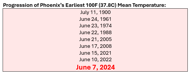
-
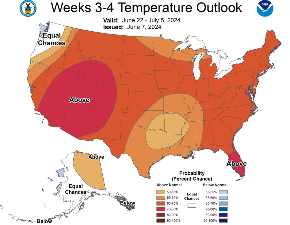
CPC Week 3-4 Outlook:
-
I suspect that NYC is 2 or 3 weeks away from the onset of a significantly hot period.
-
Tomorrow will be another refreshing day with highs in the upper 70s to lower 80s. A few spots could see a shower or thundershower. Through early next week, temperatures will continue to reach the upper 70s and lower 80s. A warming trend will likely commence after midweek. Following New York City's 4th warmest spring and Philadelphia's 6th warmest spring, there is a distinct possibility that June 2024 will rank among the 10 warmest Junes on record in both cities. Records go back to 1869 in New York City and 1874 in Philadelphia. The latest summer guidance continues to suggest a warmer to much warmer than normal summer lies ahead. The ENSO Region 1+2 anomaly was -1.1°C and the Region 3.4 anomaly was +0.1°C for the week centered around May 29. For the past six weeks, the ENSO Region 1+2 anomaly has averaged -0.48°C and the ENSO Region 3.4 anomaly has averaged +0.35°C. Neutral ENSO conditions are underway. The neutral ENSO will likely evolve into a La Niña event during the summer or perhaps early fall. The SOI was -18.98 today. The preliminary Arctic Oscillation (AO) was -1.584 today. Based on sensitivity analysis applied to the latest guidance, there is an implied 80% probability that New York City will have a warmer than normal June (1991-2020 normal). June will likely finish with a mean temperature near 75.1° (3.1° above normal).
-
Under brilliant sunshine, a refreshing breeze, and an active breeze, the New York Botanical Garden is about as picturesque as it gets.


-
Occasional Thoughts on Climate Change
donsutherland1 replied to donsutherland1's topic in Climate Change
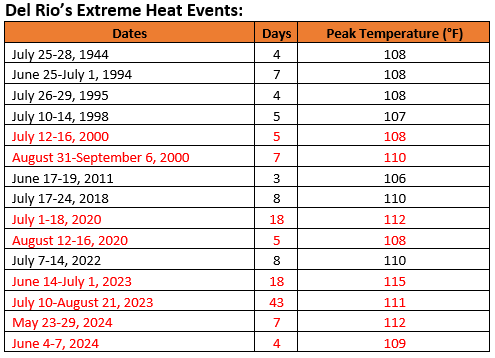
With a high of 106° yesterday, Del Rio has now had its second extreme heat event (Clarke et al., 2014 methodology) of the year. For the first time, that city has had two extreme heat events in two consecutive years. All cases with two extreme heat events have occurred since 2000. Full-year records go back to 1906. The list of extreme heat events is below. Years with two such events are highlighted in red. Climate change has driven a warming of Del Rio's climate. Summers have warmed 2.1° from 1961-1990 84.3°) to 1991-2020 (86.4°). During 1961-1990, the hottest summer (1980) had an average temperature of 87.4°. Since 2010, eight summers have been hotter, including the last six summers (2018-2023). The pre-2000 record of 88.6° from 1998 has been surpassed in five summers since 2010 and three of the last four summers. Put another way, what was once an extreme outlier summer is on track toward becoming a routine summer in the contemporary warmer climate. This warming has led to a dramatic increase in the frequency of 100° and 105° days. The number of 100° days have increased from 21.0 days per year to 41.1 days per year (1961-1990 to 1991-2020). During the 1991-2020 period, 102° days (22.1 per year) were about as frequent as 100° days were during 1961-1990. During the same reference periods, the number of 105° days has risen from 1.4 days to 5.9 days per year. As summers have warmed and intense heat has grown more common, extreme heat events have increased in frequency. This year saw the two earliest such events on record. Through June 7th, Del Rio has seen 23 100° days. It has also had 11 105° days.