

OHweather
-
Posts
4,957 -
Joined
-
Last visited
Content Type
Profiles
Blogs
Forums
American Weather
Media Demo
Store
Gallery
Posts posted by OHweather
-
-
4 hours ago, DocATL said:
Will be interesting for sure. It seems like Nina or Nino, the pacific jet continues to be the biggest influence on our weather. PV splits seem to not deliver up to the hype. But literally anything beats the current pattern. 52° right now in western suburbs of Chicago. Got to be a record high low.
.Assuming I have time tonight I'll try to put together a post laying out my thoughts a little bit more...I'd agree that the Pacific jet drove things last winter and has largely driven things this winter. Any PV split probably won't happen until about January 5-10th, and if that does couple to the troposphere and lead to persistent high-latitude blocking that blocking likely wouldn't establish itself until the second half of January. These things just don't happen on timescales that are as quick as everyone wants...you can see the early signs of a pattern that may lead to an SSW two full months before it leads to blocking, which is an eternity when the pattern sucks and you want it to change. And unfortunately many people just use those early signs as something to hype without throwing in a line about how long it would take to get results. For the time being, the Pacific jet will continue to dictate things...we'll have a period of more seasonal weather to start the New Year. It does look like there will be at least a transient period of western US troughing and eastern North American ridging in the middle 1/3rd of January, but I am leaning towards a more prolonged pattern change after that.
-
 7
7
-
 1
1
-
-
21 hours ago, Chicago Storm said:
As has been mentioned, we are heading into a significant pattern change. Changes on the large scale really start to appear this weekend and into the beginning of this upcoming week. This new pattern, which may very well evolve over time, will extend through the first 1/3rd of January, and quite possibly the first 1/2 of January.
Two big changes that we are seeing right off the bat and that have already begun are a progression of the MJO into the colder phases and a stratospheric warming event. The MJO recently entered the COD, after being in low-amplitude warmer phases from the very end of November through the first 2/3rds of December. The trip through those warmer phases is one of several reasons (Raging Pac Jet is another) that we have been stuck in a consistently mild (Sometimes very mild) regime. The MJO has now entered a colder phase, low amplitude phase 8, and is expected to make a trip at lower amplitude roughly through colder phases 1-2 over the next 1-2 weeks. Another thing that we will be watching unfold is stratospheric warming. This event is expected to disrupt the main SPV placement and strength during the potentially 1-3 week event. As is usually the case, any effects of the SSWE will not be seen right away; that is something to keep an eye on from around week 2 in January through early February.
.png.3a89226efde1d366c1eaa9979c7493ee.png)

As mentioned above, there are a few reasons we have been seeing consistently mild (Sometimes very mild) conditions over the past several weeks. The raging Pacific jet is one of those bigger reasons. The Pacific jet is expected to break down soon, with increased troughy-ness (Wave breaks) developing. Canadian ridging, which will retrograde from Central to Western Canada and eventually Alaska, will also tend to lower Pacific influence as well.

Getting beyond the MJO, SSW and Pac jet... We are likely to see a fairly consistent flow of waves/disturbances/troughs enter the CONUS along the West Coast, originating from the deep/mean trough from the Aleutians down into the Northeast Pacific. This is characterized by the lower-height anomalies from the Northeast Pacific and then across the southern 2/3rds or so of the CONUS. Additionally, with the Pacific jet breaking down and the retrograding ridging in Canada, this will lead to generally cooler/colder conditions overall than have been seen, with an airmass origin more often than not from the Northeast Pacific to Pole regions.
All in all, with this pattern change...
-While it may not be super/hyper active, there will be a steady stream of disturbances that traverse the CONUS. Will they all turn into something interesting? No. But having a feed is a start.
-It is very clearly not going to be as significantly/consistently as mild as it has been. That's not to say there won't be any bouts of mild temperatures, but what we have been seeing will be in the past for now.
-The chances for wintry storm potential are not amazing, but definitely an improvement compared to much of the past 1-2 months.Couldn't have said it better myself. Great post!! Pretty much in agreement with you.
This type of evolution, with multiple troughs ejecting out of the west as the PNA trends negative...but with some sort of a PV over eastern Canada and a bit of downstream blocking, keeping things from cutting/amplifying too much...would bring at least some snow potential to the region January 4-10th or so...maybe lingering longer if the blocking can persist.
I feel like the change to more polar influence and some blocking (both in the northern Pacific and Atlantic IMO) are strongly supported by the larger-scale drivers (tropical forcing, mountain torque, stratosphere) as @Chicago Stormlaid out. I don't think we'll get a great clipper pattern or persistent arctic air, which are the bread and butter of upper Midwest and Great Lakes snow climo, but some colder air and southern stream influence should bring trackable potentials at least.
-
6
-
2
-
-
6 hours ago, LakeEffectOH said:
I may not be correct here, but it seems like the last Huron connection we've had was in 2020. Before then, we'd get at least one per year. Bigger LES events seem to be going to WNY/Buffalo since about 2016 - the year the long term eastern snow drought began.
There was a warning-level event from a Huron band in the metro area in either early 2020 or 2021. Not entirely sure which, I was in NJ but remember a Huron band in the metro with great ratios and decent totals. Otherwise, there was a marginal Huron connection into the metro area in January of 2022 that yielded a few inches. There haven’t been many notable ones the last several years. Overall, it feels like we get bigger events from Lake Huron less often than we did when I was growing up in the 2000s. In this event the Huron band stayed farther east, it was more of a classic lake enhancement/upslope event with a NW flow…those have also been lacking in recent winters.
-
1
-
-
1 hour ago, LakeEffectOH said:
In Chesterland, I got at least 8". However looking at the storm reports around me, by certified spotters, accums are between 3.5 - 5". I checked pretty well for drifts before...estimating the depth. Strange. Maybe I better get a snow measuring device.
")
There are a lot of 6-8”+ type amounts just to your south and east farther into Geauga, but a lot of lower reports to your west and north into Cuyahoga and Lake. Most of the Geauga snow was split between reports last evening and reports this morning, but when you add reports from the same spotters together they’re almost all 6”+ in Geauga. I’m guessing there’s a gradient in there but that those higher totals in Geauga are more representative for your area. Our warning for Cuyahoga will end up being somewhat ill-fated unfortunately, with Medina, Summit and Portage all probably getting enough that they could’ve been warned instead
 . It’s been a while since we’ve had a strong NW flow event that pushes the best snow into those southern secondary Snowbelt hills like this.
-
2
-
-
6.8” here! Secondary snowbelt seemed to do well.
-
3
-
-
Off and running here, easily 3-4" so far and a nice amorphous blob of lake enhanced snow anchored over the terrain just inland from Lake Erie from the Cleveland metro across the snowbelt. I actually may get 6" down here in Macedonia, which would not be shabby at all.
-
2
-
-
Yeah this current burst has finally turned the tide here. All covered now (about 0.5”), but the hill half a mile from my house has noticeably slightly more and the middle of Macedonia (a bit lower than my house) is still struggling to cover the grass.
-
Starting to try to stick here a bit…looks like Chardon already has an inch or two on the webcam. It does look like the Huron connection will be most persistent near or just east of the OH/PA border. The synoptic support and moisture are good for most of tonight, and ratios/accumulation efficiency should get better quickly between 0-3z (should start accumulating better by sunset but ratios may not be great until a bit later when it gets colder). The synoptic support and moisture quickly pull out of NE Ohio 9-12z and out of PA 12-15z, but it’s still a pretty good period where the upslope areas should rack up some fluffy snow. We haven’t seen a NW flow event with favorable moisture and synoptic support like this in a little while. I think inland NW PA will see a general 6-12”, best shot at a foot with the Huron band. I think it’ll be more of a 5-9” type deal in the higher terrain of Geauga/Ashtabula tapering to 3-6” in the hills of the secondary Snowbelt south of Cleveland, with lower amounts in general near the lake. Accumulations will carry well inland but will gradually taper south of the higher terrain. A solid event overall. No major disagreements with the “official” forecast overall.
-
3
-
-
1 hour ago, IWXwx said:
It may have been decided to make a more blanket coverage of the worst condition areas, even if it doesn't technically meet warning criteria. The alternative would be issuing an Advisory, then having to issue long-lived, multiple Snow Squall Warnings for the affected area. However, their morning disco doesn't give a clue as to why they went this route.
We can issue Snow Squall Warnings on top of an Advisory (can not do warning on warning), although I’m guessing in practice you won’t see many offices doing them for longer-lived features like lake effect bands when the forecast and longer fused headlines can cover the threat. I certainly don’t have any issue with IWX and GRR going for warnings given the setup. On my quick thumb through I noticed some models really struggled to focus a band and had less snow so I’m curious to see how it ends up playing as an outside observer. The activity is intense right now but probably needs to consolidate more at some point to reach the forecast amounts. Unfortunately with lake effect, as we all know, to get lead time on warnings sometimes you have to go for it before you’re 100% confident in order to have a desirable POD (percent of detection) and lead time. In this case it’s not like it won’t snow and have impacts so I doubt anyone is going to fret the warnings too much in the end, I’m more curious about how the amounts pan out.
1 hour ago, WestMichigan said:I can't speak for the south end of Lake Michigan where they can get a pretty long fetch but in my area high winds like they are forecasting seem to never lead to decent snow amounts. The bands either get pushed too far inland, they don't stay on one place, or the dendrites get broken up resulting in a very fine snow. I guess we will see how this one works out for those in far SW Michigan and Northern Indiana.
Yeah that was my concern as well, as that’s what often happens off of Erie with strong winds. But I’m curious if the longer fetch can help overcome it or not. The winds may start backing off with fairly favorable conditions still in place for a time the first half of tonight but look pretty strong through today.
-
2
-
-
I'm not a Lake Michigan lake effect expert...I'm legitimately curious to see if the band can become focused enough to produce 1"+ per hour rates for a length of time or if the stronger winds will lead to a more general spray of moderate snow. The instability and synoptic support are robust, so if a focused band can develop rates of 1-2" per hour would result and the warnings would work out. However, some models struggle to focus a band in the face of the 40 knot low-level flow. Somewhat "marginal" surface temperatures and daytime timing of the heaviest snow could limit accumulation efficiency if it's more of a general spray of snow, so while there'd be poor conditions and some travel impacts accumulations would struggle to verify a warning. It feels like nasty travel conditions are likely to carry well inland in squalls, so the expansion of the advisory seems like a good move...I just don't have a great feel on how widespread any 6"+ totals would be.
-
31 minutes ago, dta1984 said:
Trends are looking good for Mon-Tues. Would be nice if what falls could stick around until Christmas...
I agree that would be nice…it’s probably unlikely for most of us, but I’m looking forward to at least getting a couple of days of a solid amount of snow on the ground with all the Christmas lights and decorations out.
-
1
-
-
We're approaching our brief allotment of winter for this two week period Monday into Tuesday. Looks like a half decent NW flow lake enhanced snow setup, peaking Monday evening through early Tuesday AM. Models disagree regarding how quickly the deeper synoptic support and moisture pull away, but the Euro and RGEM hang onto it until early Tuesday which would probably be enough to drop a good 3-6" on the higher terrain southeast of the lake, with potential for locally 6-10" wherever a Huron connection gets involved...probably in the vicinity of Ashtabula County and western Erie/Crawford PA in this sort of flow? Amounts will probably be quite a bit less near the lake with a strong flow across the short axis of the lake and warmer temperatures/lower ratios close to the lake than farther inland.
-
1
-
-
Ended up with slightly under 3" at home...the snow rates at the office and across the Cleveland area during the commute were nuts. It started snowing at about 6:15am at the office...by the time I got to my car at 7:20 there was damn near 4" on it. The drive home in the middle of all of that and the AM rush was a slow one...a couple of hills that no one was getting up, a few cars off the road and very slow going in between. It was actually a more annoying commute than what I had on December 23 last year (in the middle of the blizzard with brutal cold), though I think that was more a product of more traffic volume this morning. Overall am pretty happy with how the event played out, although northern Erie County PA got way less than forecast. As we move into December, I think it's time for us to get a more widespread snow at some point!
-
1
-
-
Things still look pretty on track. The flow comes around to a good 290 degrees for several hours Tuesday morning, so I don't doubt snow will get into most of the metro area and probably will at least briefly get down to me (I'm in Macedonia now). I'm not expecting more than a quick couple inches here, though some models have a bit more this far south. Should be a fun commute home from the office in the morning. In the Cuyahoga/Geagua area, there is still some uncertainty regarding exactly how heavy the totals are (though I don't doubt the entire area will get a very intense burst that puts down a few inches early Tuesday, at least). Pretty confident that Lake, northern Geauga, northern/central Ashtabula and most of Erie County will be under banding for several hours tonight before it starts pushing farther inland, so they'll do just fine. The band may end up sinking across Cuyahoga and the rest of Geauga a bit quicker, so for those areas to get higher-end totals closer to 8 or 10" it'll need to snow more Tuesday and Tuesday evening behind the initial band. I do think there's a chance that we end up seeing a more fractured (but still coherent) band sit across parts of Cuyahoga into southern Geauga and maybe even northern Summit/Portage/Trumbull for the rest of Tuesday morning behind the initial burst, as winds end up locking in around 290 for several hours which can focus a band in that area. Instability and snow growth are supportive of heavy snow through a good portion of Tuesday, but the question after the initial burst early in the day is how organized any banding can be. Activity probably does get pretty disorganized for a few hours Tuesday afternoon (some subsidence/shear) but may organize into one final burst Tuesday evening as winds start backing and pushing the activity back up the lakeshore.
-
1
-
1
-
-
Looks like a very potent event for the primary belt later tomorrow and Tuesday, with a very heavy band likely impacting the metro area during the Tuesday AM rush.
-
2
-
-
2-2.5” in Macedonia. Roads were slush covered at 6:30 when I left. Not a bad start!
-
4
-
-
11 hours ago, LakeEffectOH said:
OHweather, what are your thoughts about the upcoming winter? Hopefully it will be better than last winter.
Here are my comments from the other Ohio thread regarding this winter...I think there's a reasonable chance that we locally see more snow than last winter, but it's hard to expect average or above snowfall IMO.
"Off the cuff, I've had some mixed feelings but unfortunately am leaning pessimistic for our region. Now, could it be somewhat better than last winter? Sure. But much more than that probably is asking a lot. It is looking increasingly likely that this winter will feature a strong, east-based or traditional El Nino. Water temperature anomalies are already near +1.5C in Nino region 3.4, and don't appear likely to start cooling anytime soon. And the warmest anomalies are closer to South America, making this a more traditional El Nino. This likely means the sub-tropical jet will be quite active and that Pacific air will frequently flood the continent, making it hard to build up true cold air over Canada. This will be an El Nino with a -QBO (easterly wind anomalies in the stratosphere), which is a good combination for possible disruptions to the stratospheric polar vortex. That could lead to a -AO/-NAO trend later in winter. So, if we do see a period of blocking and the sub-tropical jet is active perhaps there's some potential for a larger system to produce snow out of the sub-tropical stream. However, I think the strong El Nino and lack of Arctic air will lead to fewer clippers than normal and generally less snow than normal, unless we get lucky with some sub-tropical jet help.
There has been a lot of talk that this isn't a winter to use strong El Nino climo for the winter outlook, and I understand some of the reservations as the pattern hasn't acted like a developing strong El Nino this summer. I think the lingering affects on the atmospheric circulation after 3 years of La Nina, aided by a strong -PDO, and the anomalous warmth of the Atlantic offset the atmospheric response to the developing El Nino...however, I believe we're starting to see the atmosphere respond to the borderline strong El Nino and strong positive Indian Ocean dipole. Tropical forcing is beginning to become more persistent over the western Indian Ocean and the Pacific. While perhaps the lingering oddities can lead to a random cold shot in later November or December if we briefly get some help from the MJO before the El Nino pattern truly locks in, I'm thinking this winter does act like an El Nino, leading to my overall pessimism. With that said, I've been wrong about these things for sure, and I'll try to look more in-depth over the coming weeks."
As for the LES event Tuesday night into early Wednesday, the instability is extreme and the synoptic support is quite good. I think a band of very intense precip, with plenty of lightning, will come crashing onshore late in the evening from the Cleveland metro points east and slowly sag inland. It'll be moving but it'll be very intense. Capable of multiple inches of snow in an hour or so of time, especially in the higher terrain. Model soundings show very strong lift in the DGZ, along with cold 925mb temperatures of -2 to -4C and surface dew points a bit below freezing. I think this argues for locations more than a few miles away from Lake Erie seeing the bulk of this precip fall as snow. It'll be a quick burst with the trough. Instability remains strong into Wednesday morning, and there are hints winds get aligned out of the NNW for a few hours around sunrise, which may allow for a few narrow multi-bands to develop after a lull behind the initial trough passage and burst of snow. There will be a Huron connection somewhere in NE OH that may be a bit more organized/intense Wednesday morning. Activity should weaken more substantially and change back to rain or a mix by Wednesday afternoon.
I think it'll be a general 1-3" deal, with up to an inch of slop near the lake but generally struggling to change to snow near the water. Accums should get as far south/west as Lorain/Medina/Wayne Counties and down into the Akron/Canton/Youngstown areas. With good synoptic support, the activity should persist well inland though it will lose some intensity as it gets farther from the lake. There may be spots where the band hangs up a little longer, or where the narrow multibands set up early Wednesday. If these aligns with the higher elevations, hi-res models all spit out upwards of 0.75" of QPF in spots. Even if that is somewhat overdone, there's enough QPF to play with to get 4 or 5" of wet snow where bands are most persistent away from the lakeshore. Hopefully enough leaves have come down to mitigate tree/power-line issues, but there may be a few.
-
2
-
1
-
-
5 hours ago, pondo1000 said:
Hey there! Did you do any winter forecast yet? Would be very interested in your thoughts. Thx!
I haven't put one out yet. I will try to over the next few weeks, or at the least post some medium-long range thoughts in the long range thread. Off the cuff, I've had some mixed feelings but unfortunately am leaning pessimistic for our region. Now, could it be somewhat better than last winter? Sure. But much more than that probably is asking a lot. It is looking increasingly likely that this winter will feature a strong, east-based or traditional El Nino. Water temperature anomalies are already near +1.5C in Nino region 3.4, and don't appear likely to start cooling anytime soon. And the warmest anomalies are closer to South America, making this a more traditional El Nino. This likely means the sub-tropical jet will be quite active and that Pacific air will frequently flood the continent, making it hard to build up true cold air over Canada. This will be an El Nino with a -QBO (easterly wind anomalies in the stratosphere), which is a good combination for possible disruptions to the stratospheric polar vortex. That could lead to a -AO/-NAO trend later in winter. So, if we do see a period of blocking and the sub-tropical jet is active perhaps there's some potential for a larger system to produce snow out of the sub-tropical stream. However, I think the strong El Nino and lack of Arctic air will lead to fewer clippers than normal and generally less snow than normal, unless we get lucky with some sub-tropical jet help.
There has been a lot of talk that this isn't a winter to use strong El Nino climo for the winter outlook, and I understand some of the reservations as the pattern hasn't acted like a developing strong El Nino this summer. I think the lingering affects on the atmospheric circulation after 3 years of La Nina, aided by a strong -PDO, and the anomalous warmth of the Atlantic offset the atmospheric response to the developing El Nino...however, I believe we're starting to see the atmosphere respond to the borderline strong El Nino and strong positive Indian Ocean dipole. Tropical forcing is beginning to become more persistent over the western Indian Ocean and the Pacific. While perhaps the lingering oddities can lead to a random cold shot in later November or December if we briefly get some help from the MJO before the El Nino pattern truly locks in, I'm thinking this winter does act like an El Nino, leading to my overall pessimism. With that said, I've been wrong about these things for sure, and I'll try to look more in-depth over the coming weeks.
-
2
-
-
Probably won't stick more than some grassy coatings here and there, but it looks like most of the state will see their first flakes with a potent trough passage Tuesday evening. Maybe even the bursty convective stuff in a few spots.
-
2
-
-
Looks like a nice burst of lake enhanced snow Tuesday night as a shortwave moves through. SW winds will shift NW, so probably just a gradually moving burst with the trough axis transitioning to weaker multi-bands behind the trough. It looks like activity shuts down pretty quickly into Wednesday morning. Instability with the setup is extreme, with lake to 500mb temperature differentials of about 50C along with good synoptic support. The band/burst that crashes ashore with the trough axis probably will be accompanied by some lightning. It seems like this burst could affect much of the snowbelt in NE OH/NW PA (both primary and secondary), along with the Cleveland metro and perhaps some counties farther west along the lakeshore. Most areas probably only see a couple hours of good precip, though sometimes these bands can pivot a bit and last a little longer in a localized area as they work through.
Temperatures will be marginal, though with dew points away from the lake falling into the 20s and 925mb temps dipping to -2C I think it will be cold enough for this burst of precip to fall as mainly snow and graupel away from the lake and probably more graupel with some rain and wet flakes mixed in closer to the lake. Forecast soundings suggest there will be good flake production aloft. Along the lake it may be tough to accumulate much as the ratios will be very low, but inland a bit from the lake could see a 1-3" type accumulation across much of the metro area and snowbelt. There may be enough QPF to play with for some of the highest hills to get a little more than that, but they'd have to get lucky and have a band sit over them.
It won't last long, but I'm pretty optimistic many of us wake up to some snow on the ground Wednesday morning.
-
1
-
1
-
-
On 8/22/2023 at 9:46 AM, TheClimateChanger said:
Nothing here, anyways: Past Seasonal Snowfall (weather.gov)
We haven’t made the map yet. Hopefully before the flakes start flying at this rate (the data isn’t going anywhere)
-
On 7/20/2023 at 4:34 PM, NEOH said:
I believe it was sent... too depressing to look at so I deleted it. OHWeather would likely have it.
I will check and see if we produced one. We tallied up all the snow spotter totals but I'm not sure if there's a map to go with it.
-
33 minutes ago, NEOH said:
Woke up to snow cover this morning. Plows were out removing slush from the roads. If any more had accumulated there would have been tree damage. Temp is now up to 35 so everything is melting. Very little accumulation in areas below 1,000 ft.
Was wondering how that band performed when it sank into your area. It snowed hard for a couple hours in Chardon very early this morning, and while accumulations weren't much into Cuyahoga County the heavy snow/graupel in the band made 271 slick during the commute and caused accidents. Luckily the band was moving because if it would've sat in one spot for its duration it may have dropped several very dense inches...we would've needed at least an advisory if not more due to what would've happened to the trees. Pretty impressive setup for May. No accums anywhere between the office and my house (Brooklyn Hts/Reminderville) but we had a nice graupel shower yesterday afternoon and wet flakes did mix in this morning. We've seen snow in the month of May in recent years much more than what I remember up through about 2015. I believe in 2016 we had some May snow that stuck a bit in parts of the snowbelt and then again in 2020, 2021 and 2023. With that said, it's snowing less in the months it is supposed to snow in recent years, probably a trade none of us want to make.
-
On 4/25/2023 at 12:40 PM, dta1984 said:
Agreed, let's close out winter. 49.5" is my total, and low since I've been keeping track.
What's your take on the long range? Are we close to getting back to some spring temps? I've got an outdoor wedding end of next month....
Congrats!
I have been wondering if we can get into consistently above normal temperatures again anytime soon...just has been an impressive tendency the last couple weeks for blocking/a -NAO pattern which keeps forcing a trough over eastern Canada and the NE US. I do think we'll gradually warm up through May (after the next 7-10 days it shouldn't be a s bad as it is right now) but it'll probably be tough to get prolonged warmer than average weather for a good portion of the month.
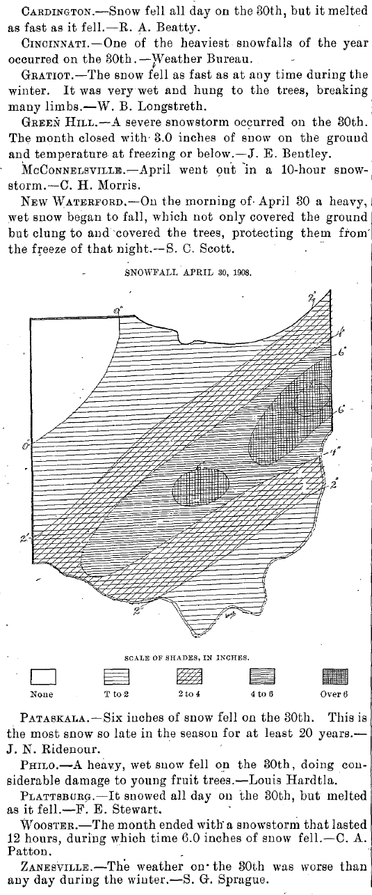
1 hour ago, TheClimateChanger said:The 115th anniversary is approaching for a little known snowstorm that occurred on April 30, 1908. Most of the state saw accumulating snow, with about 6" near Columbus and 9" near Youngstown. From the April 1908 Ohio Monthly Weather Review:
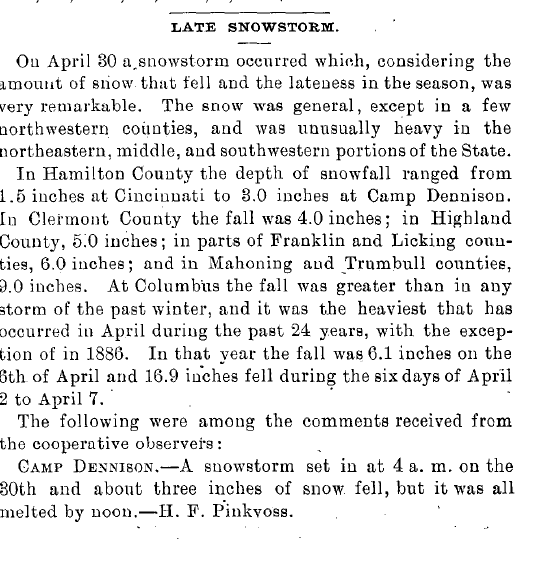

6" in Columbus on April 30th is pretty hard to imagine!
-
1
-


Winter 2023/24 Medium/Long Range Discussion
in Lakes/Ohio Valley
Posted
Wanted to lay out some things happening with some larger scale pattern drivers now and over the next few weeks and look at how they may impact chances for cold and snow potential. Chicago Storm's post on the prior page touched on most of these things. Behavior of the Pacific jet and potential for high latitude blocking will determine much of how this goes...something that can probably be said most of the time in the winter months.
Not to be a wet blanket here but I don't want to get expectations unrealistically high at this point. Much of the subforum is going to be in a rather substantial seasonal snowfall hole before any sort of sustained colder pattern develops. In a strong El Nino it's inherently harder to get into a polar jet dominated pattern with lots of cold, clippers, and lake effect snow...those are patterns that are productive for much of the Midwest and Great Lakes. The mid-Mississippi and Ohio Valley portion of this subforum has lower annual snowfall and may get lucky with an active subtropical jet in an El Nino, so on that I would say that region has the greatest potential to rally and finish near or somewhat above average snowfall at this point...if anyone can. For the rest of the sub a below average seasonal snowfall is by far the more likely outcome at this point, but the pattern will be colder and more conducive to snow at times so I don't think we're looking at another year without a winter. We should see some windows of more wintry conditions.
A significant influence on the Pacific jet stream is East Asian Mountain Torque (EAMT). Remember that big cold blast in Siberia earlier this month? The Arctic high associated with that dropped across eastern Asia (and is still doing so early in the above loop). This denser airmass and higher pressure east of the Himalayas puts a torque against the planet's rotation, slowing it down an imperceptible amount. To conserve momentum, this is compensated for by speeding up the jet stream over the Pacific...promoting stormier conditions over the northern Pacific. The Rockies can have a similar affect on the jet stream over the north Atlantic.
Note how a strong positive EAMT event occurred over the last week or so as the Siberian high dropped into eastern Asia. EAMT will generally trend more negative over the next 2-3 weeks, though I'd say it's possible we see one last little push of +EAMT in the first few days of January which may be important to determining how quickly the Pacific jet retracts in the coming weeks.
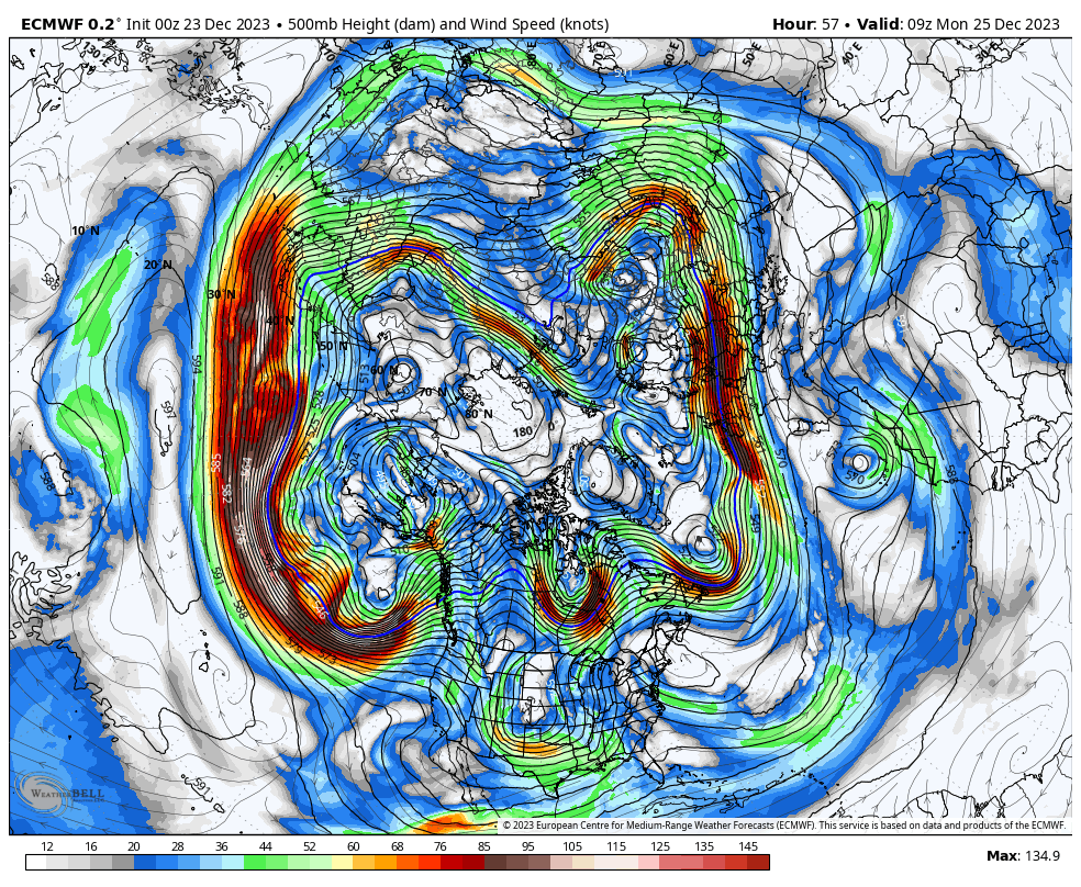
The strong +EAMT led to the dramatic intensification of the north Pacific jet ongoing now, though the jet will begin retracting over the coming days and continue retracting/weakening into early January as EAMT trends more negative (and as tropical forcing changes, will get into that below). The stronger jet leads to stronger ageostrophic flow within its embedded jet streaks, encouraging a stormier (and amplified) pattern, especially near the eastern edge of the jet where the upper-level flow is most diffluent.
As the jet reached its easternmost extension over the last few days the stormy pattern was over the southwestern US with ridging amplifying northeast of that. As the jet begins retracting over the next several days the stormy pattern will shift west into the Pacific, allowing ridging to shift west towards the west coast and Alaska while continuing to amplify. This jet evolution has strongly contributed to our ongoing mild pattern and the change will contribute to a period of cooler conditions to start January.
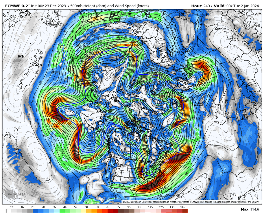
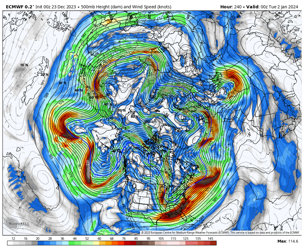
https://www.atmos.albany.edu/facstaff/awinters/realtime/Deterministic_NPJPD.php
Wanted to demonstrate how important the Pacific jet has been on the pattern we are seeing. Per the analysis, we went from a jet retraction in mid December to a recent poleward shift of the jet. The jet is expected to be more characteristic of the "jet extension" phase the rest of this month, before briefly moving through an Equatorward Shift space back towards jet retraction (due to the negative trend in the East Asian Mountain Torque).
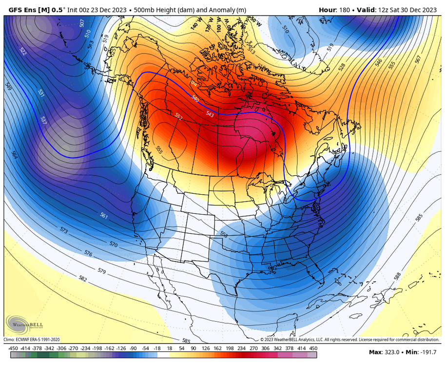
Poleward shift heights and resultant temperatures:
A very Pacific-dominated pattern with minimal polar/arctic influence and very mild conditions across a good portion of Canada and the northern CONUS. Very similar to what we're currently seeing.
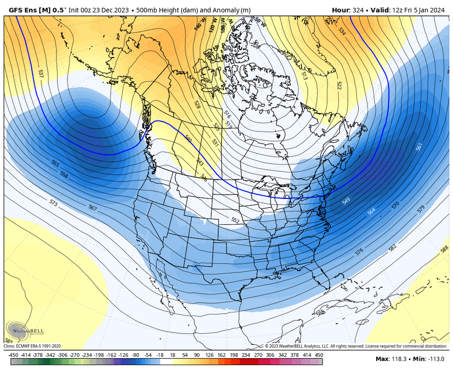
How about a jet extension, which is what we'll see over the coming days?
Supports increasing heights along the West Coast and into Alaska, less Pacific influence, and at least some polar and arctic influence into North America, with cooler anomalies over parts of the eastern U.S. Looks a bit like the pattern showing up on the models and ensembles over the next week.
An equatorward shift is inherently hard to sustain in an El Nino but is most conducive to EPO-induced cold shots into southern Canada and the CONUS:
Jet retractions favor flatting ridging farther west over the North Pacific...a -PNA pattern, which is showing up in the extended ensembles...
Tropical forcing is also influencing the pattern...the MJO is making a fairly amplified pass through phases 1-2 through early January:
This supports amplification of western North American ridging and at least some semblance of a -NAO (Phase 1 top, Phase 2 bottom):
https://www.atmos.albany.edu/facstaff/roundy/waves/rmmcyc/index200reg.html
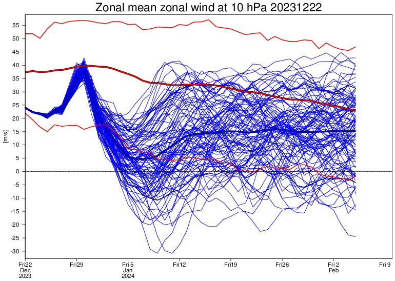
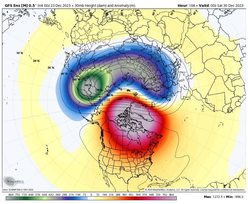
So far the East Asian Mountain torque and tropical forcing do a good job of explaining the evolution of the Pacific jet and the recent/upcoming North American pattern. The troposphere and stratosphere have seemed to be relatively well-coupled so far this season, with an amplified pattern in the troposphere in late November and early December leading to increased upward heat and wave fluxes into the stratosphere. This has led to an ongoing stratospheric warming event that appears poised to downwell into the troposphere.
https://stratobserve.com/anom_ts_diags
Not only do the mountain torque and tropical forcing support amplified ridging on the west coast into Alaska the rest of this month into early January, along with perhaps a -NAO, but the downwelling negative AO out of the stratosphere supports high-latitude blocking. Lots of factors supporting the pattern change that will be getting underway very soon.
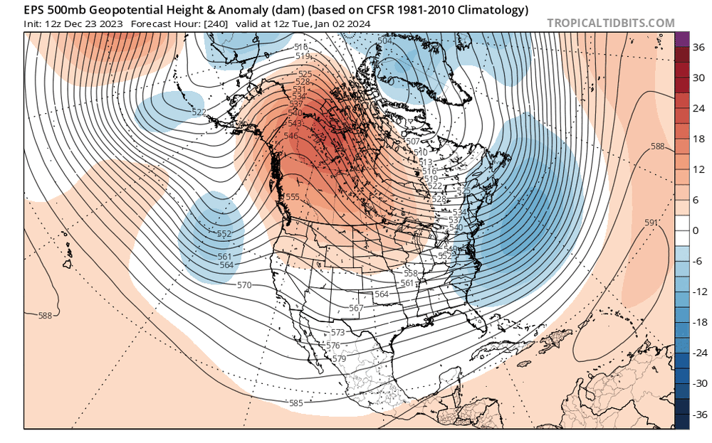
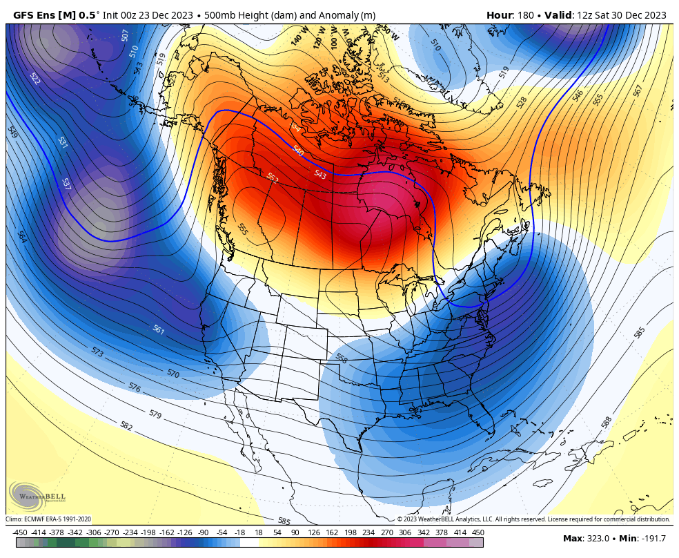
Here's a look at the EPS mean 500mb and surface temperature forecasts through the upcoming pattern change:
The 500mb evolution shown on the ensemble seems strongly supported by the various forcings described above over the next 10 days. The ongoing storm over the central U.S. starts carving out a trough over the eastern US over the next several days, with amplifying ridging on the west coast deepening the trough over the next 10 days as energy ejects out of the southwest U.S. in the subtropical jet. This leads to increased polar influence into Canada and the U.S., but the source region is currently very mild which will take quite a while to completely overcome.
The result is a cooler trend over the CONUS, especially over the southern U.S. where the active subtropical jet keeps conditions more active. Over Canada it remains generally mild for the foreseeable future but certainly trends much less mild than recent conditions. It's worth noting that this is a change from temperatures well above freezing all the way to Hudson Bay to sub-zero temperatures (on the ensemble mean) down to at least that latitude:
The tug of colder air behind the current Plains storm is very meager but the colder air becomes much more "tappable" by the beginning of January, so any storms that develop will be able to pull in seasonally cold air. Nothing crazy but certainly much more wintry feeling that at the moment. Note those frames are all 12z which catches something close to the daily lows.
While the tropical forcing, mountain torque/Pacific jet, and stratospheric influence support upcoming amplification of ridging along the West Coast into Alaska and perhaps a -NAO, there are certainly hints at a more -PNA pattern taking hold in two weeks. Is that legit?
Recall back to the SLP loop and the mountain torque discussion:
A sustained negative EAMT event appears likely in early January, supporting retraction of the Pacific jet (and a -PNA). Note how a similar evolution (about a week later) of Rocky Mountain Torque supports ridging over the North Atlantic, as a +RMT and strong North Atlantic jet to start January gives way to a -RMT and weakened North Atlantic jet by the second week of the month.
https://charts.ecmwf.int/?facets={"Product type"%3A[]%2C"Parameters"%3A[]%2C"Type"%3A[]%2C"Range"%3A["Extended (42 days)"]}
There is some uncertainty regarding how the MJO evolves beyond the next 10 days. Many ensemble members have the wave weakening and moving into the "circle" in the day 15-20 range (blue and green dots, valid the 2nd week of January). A number of members maintain amplitude into phase 3 and some into phase 4 and 5. That seems unlikely but the ongoing stratospheric warming event may support a stronger and more amplified MJO moving across the Indian Ocean and into the western Pacific mid-late January...a trend worth monitoring. Even a phase 3 MJO in early January suggests a trend to a more -PNA/west coast trough:
To sum up where things are so far:
Tropical forcing, mountain torque/the Pacific jet and stratosphere support a pattern change over the next week. This will increase polar influence into Canada and the U.S. and favor development of an eastern U.S. trough during the first week of January. Mountain torque and tropical forcing suggest continued Pacific jet retraction in early to mid-January, which will encourage ridging to retrograde across Alaska as troughing over the eastern CONUS also retrogrades/shifts west. This will lead to conditions initially supporting any southern stream systems bringing a wintry threat to the interior Southeast/Mid Atlantic the first few days of January, but with wintry potential shifting west across this subforum in the January 4-10 range...perhaps lingering through the middle of January if ridging doesn't shift west towards the west coast too quickly. With generally mild conditions persisting over Canada the pattern won't favor strong clippers or huge arctic outbreaks that can set off days-long lake effect snow storms, but southern stream storms may be able to bring swaths of snow if they phase enough with the polar jet. And, a modest clipper and some lake effect could still be possible with Canada trending more seasonal.
Looking further ahead, a number of EPS members have a significant stratospheric warming event (SSW) between January 5-15. If this occurred it would lead to greatly increased potential for sustained high-latitude blocking beginning in late January and persisting well into (and perhaps through) February. It is very common for a warm-up to occur over the central and eastern U.S. as a stratospheric warming event is ongoing, before any blocking it sets off can establish. This would line up with hints of a -PNA and +EPO towards the middle of January.
https://www.cpc.ncep.noaa.gov/products/precip/CWlink/MJO/mjo.shtml
Looking at tropical forcing, the forcing has generally been amplified over the central Pacific (near 180 longitude) and over the western Indian Ocean (near 25E), roughly outlined by the green boxes. Tropical forcing has generally been suppressed between these two areas. The tropical forcing has moved through the western hemisphere (phase 1 MJO and favorable for colder weather) every 3-4 weeks.
If this continued it would move back through the western hemisphere by the middle of January. However, it seems like the tropical forcing was more driven by faster-moving Kelvin Waves until the two most-recent orbits, which featured stronger and slower-moving anomalies more typical of the MJO. This most recent pass remained strong through the eastern Indian Ocean subsidence zone but also took closer to 4-5 weeks to return to the western hemisphere. If this more recent trend continues it will return to the western hemisphere in the ~3rd week of January and support a more favorable Pacific influence on the pattern, along with a -NAO. However, the stratospheric warming event over the pole leads to a colder lower stratosphere over the tropics, which may amplify and slow down the progression of the tropical forcing. I would say smart money is on tropical forcing becoming favorable for a western North America ridge to return during the last week of January. Potential exists for prolonged -NAO blocking by then if we do in fact see a major stratospheric warming event (which appears likely during the first half of January).
After the cool down into early January, leading to a favorable pattern for any amplified southern stream system to bring snow potential to the region in the January 4-10th timeframe, along with perhaps a modest clipper and some lake effect, a trend towards a trough with colder air over the western U.S. and ridging farther east is supported for the middle portion of January. By the end of January potential appears to be there for impacts from a stratospheric warming event and tropical forcing to support a western North American ridge, eastern trough, and high-latitude blocking with an active southern stream. This would lead to a few week period of more wintry weather, and while unlikely to make up for seasonal snowfall deficits completely could salvage a semblance of a winter in the region.