

OHweather
-
Posts
4,887 -
Joined
-
Last visited
Content Type
Profiles
Blogs
Forums
American Weather
Media Demo
Store
Gallery
Posts posted by OHweather
-
-
In Novi, MI right now and the squall the just hit pounded. Quick inch inch and a half in less than half an hour.
-
 1
1
-
-
57 minutes ago, NEOH said:
Your forecast looks good. Really hoping for the ridging to take its time moving in. Enjoy the game... that's a long way to go to watch the Browns
")
Upper deck tickets were less than $20! Figured it was worth it, going up this evening and making half a weekend out of it.
14 minutes ago, dta1984 said:Interesting that a few short rangers keep the bulk of the accumulation farther south, and not much near the lake shore.
I think that is a plausible scenario...the winds over the lake turn 90 degrees in 6 hours tonight, I feel like we're going to see that burst push through the lakeshore quickly. It will be heavy, but I'm not sure if it can add up more than a quick couple inches right near the water.
-
1
-
-
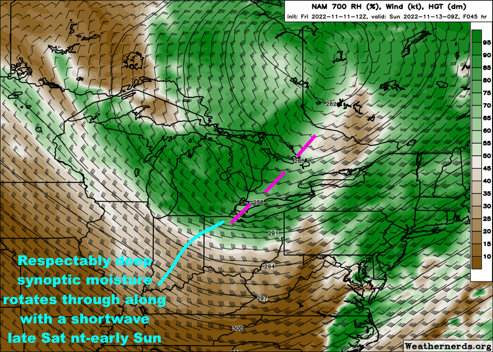
Still looks like a very intense burst of snow pushes onshore into most of the primary snowbelt late this evening with the cold frontal passage. However, winds come around quickly so the burst will be transient, with WNW flow bands setting up behind it. Still a short duration event, with ridging building in midday Sunday and beyond, significantly weakening bands and shifting them back northeast again quickly through the afternoon.
Between the synoptic moisture/support with the cold front, apparent connection to southern Lake Michigan, and crazy instability, parameters are very favorable for heavy snow late this evening through early Sunday. Conditions quickly decline on Sunday, though bands can probably still produce localized moderate to heavy rates through the morning before losing more punch by the afternoon. It will also be windy and the snow will be very fluffy, so it'll blow around.
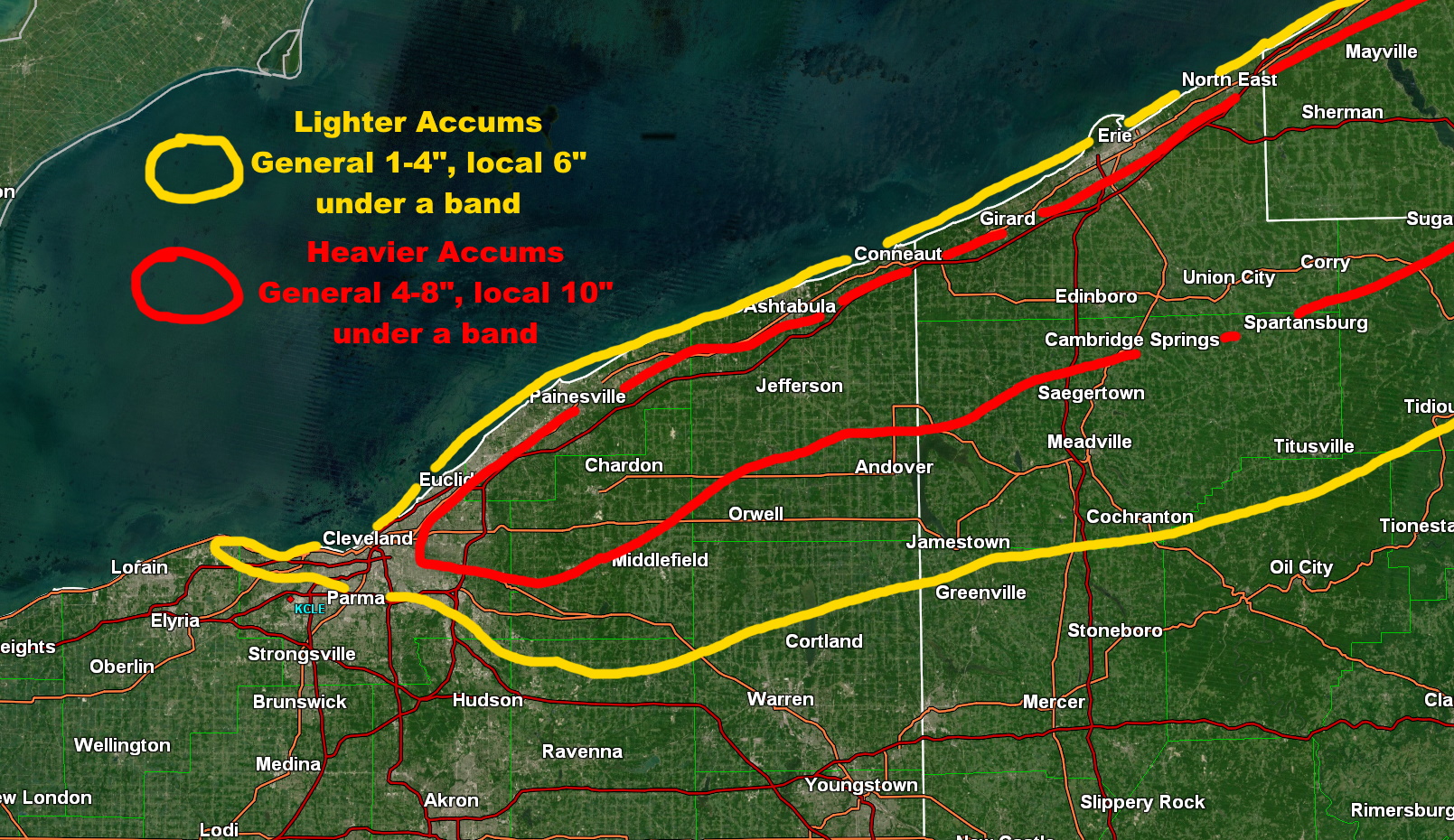
In terms of accums and the warnings, given the short duration of the event and transient bands I do worry that many areas will struggle to quite get to the forecast snow amounts. I do think where those WNW flow bands set-up for several hours later tonight into Sunday morning can get to the forecast, as rates of 1-2" per hour are likely through early Sunday under more organized bands, however those bands will not impact the whole area so those higher totals will be localized...otherwise, probably a general spray of light to moderate accums from the burst along the front followed by the lingering snow showers outside any bands. There is good model consensus that one band with a Lake Michigan connection sets up from somewhere in northern or northeastern Cuyahoga County into Geauga and perhaps far southern Lake, and that may be where some of the heaviest totals occur. Otherwise, we often see a couple other bands set-up in this type of flow from parts of Ashtabula County east across Erie County.
Here is a very rough representation of the totals I'm loosely thinking of:

A big question mark is where that westernmost band sets up...winds briefly come around to 285 or 290 for a few hours early Sunday, which could get it into a good portion of Cuyahoga and even northern Summit/Portage, but it will have an upstream connection to Lake Michigan and we've seen those types of bands get stuck up closer to Euclid or Mayfield before. Otherwise, I think the rest of the inland core snowbelt gets marginal warning criteria amounts with locally heavier amounts under a couple of persistent bands, with advisory amounts surrounding that. I think the warnings as they are were probably all needed, though I could quibble about the Ashtabula and Erie lakeshore zones maybe being more advisory-worthy I suppose. Cuyahoga has some bust potential, but that western band may be the most dominant and the vast majority of indications are it at least gets into the eastern suburbs, so I think there wasn't much choice but to warn Cuyahoga.
I was talked into going up to Detroit later today through the game tomorrow, so I will not be home for this...I guess I'll see if there's any snow on the ground when I get back tomorrow evening.
-
1
-
-
The HRRR also gets a gold star for its performance in Ashtabula County OH (northeast corner of the state) and Erie PA this last evening...its runs the night before had up to half an inch of QPF in Ashtabula (they got 2-4") and up to 1" of QPF in Erie County PA (they got up to 8")...the QPF was overdone, but it was sniffing something out. That said, subsequent runs showed almost 1.50" of QPF on top of Erie, that was a little overzealous.
0z HREF PMM slightly too snowy, but got the idea right:
.thumb.png.62a5ac6c24a694cf890af324d5f5f7bf.png)
The 0z Friday RGEM kept it out over the lake, a swing and a miss...
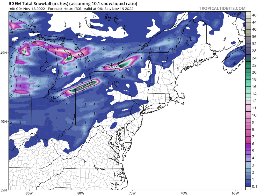
As for the rest of this weekend, the progressive nature of the trough leads to a short lived set-up with shifting winds spreading totals out, but on the plus side, the sharpness of the upper-level trough and origins from over Siberia (see loop below) will encourage very intense squalls off the mild November lakes along with gusty winds.
A lack of band persistence/longevity will be a limiting factor overall, but if any persistent bands or upstream connections develop heavy rates would allow snow to quickly add up on a highly localized basis.
.thumb.gif.bdf1f7f8ff0565c340a9e66a4cdf7845.gif)
-
1
-
 1
1
-
-
30 minutes ago, BuffaloWeather said:
KBUF missed the boat on this forecast. They trusted the RGEM and expected thermal troughing too much in the forecast. HRRR nailed it.
I'm honestly surprised (though, it's an error of only a few miles), they use an extensive analog method and have it down to a relative science exactly where the bands will go with a given wind direction, and often times leaning heavy on the RGEM works. With that said, the RGEM was a little too far north with the leg of the event on our side of the lake into NE OH/NW PA Wednesday night/Thursday AM as well, and I think while the other models often place the banding too far south, sometimes the RGEM is a little too extreme in the other direction. Curious if downtown makes up some ground later tonight into tomorrow when the wind goes more SW/SSW.
Regardless, another epic storm for your area.
-
3
-
2
-
-
A little surprised we hoisted a watch for this already...that said...the synoptic support, moisture, and instability over the lake support a very intense and high-ratio snowband (potentially with thunder and lightning) crashing ashore late Saturday evening into the overnight. However, this band along the front will move quickly so it's probably just a quick coating to couple of inches, then we see where any lingering bands set-up in the WNW flow behind the front. As NEOH said, a short window as ridging and dry air quickly build in on Sunday. It should snow decently under bands into Sunday morning but expect stuff to start shifting northeast and falling apart into the afternoon. While the flow over the lake goes WNW, with ridging building in quickly I could see the band getting to northern/northeastern Cuyahoga and southern Lake into Geauga behind the front and sitting for several hours before weakening/lifting, with probably one or two more WNW-ESE oriented bands with upstream connections into eastern Ashtabula and NW PA. These bands, especially the westernmost one into the east side of Cleveland, will be the best shot to crack warning criteria (6"+). It's certainly possible, but I think warning amounts are pretty localized as the band along the front moves too quickly and the whole event is short duration. Still almost 36 hours to monitor trends in wind direction and the overall organization/longevity of any bands.
-
Someone near West Seneca will probably get close to 5 feet. Will end up being very similar to the first leg of the massive 2014 storm, perhaps slightly to the north.
-
1
-
-
Slightly over an inch here this morning. As always down here, I'll take what I can get with a mainly WSW flow event. Northern Ashtabula County (into the Erie area) got absolutely crushed. Ashtabula was jussst starting to snow at 11:30 PM when I left the office last night, and was measuring 14-17" by 7-8 AM today. Believe I saw that I-90 was closed for at least a period of time.
-
1
-
-
27 minutes ago, BuffaloWeather said:
As the lake effect expert on this board what are your thoughts on this event further north near Buffalo? Trying to find the best location to ride this out in. Was thinking 2-3 miles south of the airport? Any chance at thundersnow?
It's certainly a stellar set-up as NWS BUF has been screaming about for several days now...a prolonged period Thursday evening through Saturday night with moisture depth of 10-15k feet on forecast soundings (especially through early Saturday morning), extreme instability with lake to 850mb differentials of 22-24C and lake to 700mb differentials of 30-32C, and equilibrium levels of 20-25k feet...all these values support very deep and intense lake effect off the east end of the lake with thunder.
I'm pretty impressed at how steady and close to due southwest the flow is late Thursday night through early Saturday, which seems to be a fetch that favors the city and airport or just south (but not quite as far south as 2014), so the band will probably move little in that timeframe and dump on that general area. I think slightly south of the airport is a pretty good spot, but you have watched those bands closer than I have so you may have a slightly better judgement on where they go with a certain wind direction. Regardless, the amount of moisture, instability, lack of shear, and good lift shown in the snow growth zone supports 2-4" per hour snow rates in the band and if it moves very little for 24-30 hours someone can get 3 or 4 feet...we'll see if it wiggles just a bit and prevents such insane totals, though the flow looks pretty steady...
-
1
-
-
It will be fascinating to watch how tonight plays out…I would not take the “over” on how far south the band briefly swings late tonight into early Thursday, but it could get as far south as eastern Cuyahoga and central/southern Geauga briefly early Thursday before breaking up a bit Thursday morning and shifting back northeast later in the day.
The real interesting area will be closer to I-90, as the band looks to hug the lakeshore for several hours this evening into tonight while getting very intense. Despite the warm lake, that could bury parts of the I-90 corridor. It will be interesting to see what ratios are like and how well it accumulates despite the marginal temperatures, but the feeling is that the intensity will be enough to overcome any temperature issues.
-
7 minutes ago, Hoosier said:
Definitely think that is the window to watch for the city proper. It's an extreme thread the needle though because they'll need to be perfectly positioned on the western end of the convergence area to take advantage of winds flipping more offshore, but not so much that the activity gets shunted quickly east.
For sure, just saw you commented similar on the prior page. The place to be will be inland a bit where it's not quite as warm but you still get the added benefit of lake enhancement, anything near the lakeshore is more of a parting gift if it works out.
-
On 11/13/2022 at 4:32 PM, IWXwx said:
I caught the very first tornado that day, an F-1 in Hartford City, IN. The same supercell that later dropped the Van Wert F-4.
I was too up close and personal with it as it passed a couple hundred yards in front of me before smacking the Marsh grocery store. That kept me from chasing it, because I had to stop to check on injuries at the store. Otherwise, I probably would have chased it into Ohio. It also put down 2 more short-lived tornadoes (Wells and Adams Co.) before dropping big one.

Pretty crazy that a cyclic supercell dropped that many tornadoes in northeast IN/northwest OH in mid November! And obviously, the F3 and F4 were quite substantial.
A couple of other rather intense tornadoes occurred that day...one in particular hit Tiffin in north-central OH. It's possible it was stronger than a 3 based on how many houses it swept clean:
https://www.weather.gov/cle/event_20021002_tornado_outbreak_tiffin
-
2
-
-
This is a tough call for right along the lake...our couple of LES events recently have struggled to produce all snow up to the lake until 850mb temps get to about -8C (they've been mixing to the lake at like -5 or -6C if it's heavy enough but not fully going to snow until a bit colder). I'm guessing that between the marginal 850mb temps, onshore wind, urban influence that it'll be tough in Chicago...there could be a window Tuesday night into early Wednesday if surface winds can back more offshore before the lake enhanced band shifts east.
-
Nov 10, 2002...Veteran's Day tornado outbreak. One of my first actual solid wx memories where I remember what I was doing that day, remember coverage of the event and some meteorological details, etc...an F2 tornado went through my town and missed my house by 100 yards. Probably the closest I'll ever be to a tornado (knock on wood)
-
1
-
-
On one hand I’m surprised the band hung north for as long as it did, but on the other that happens often. Some 2-3” reports from Lake and northern Geauga looks like. It’s been snowing off and on pretty good the last couple of hours here, the ground is covered but it’s melting from below when it slows down…have had up to half an inch at any one time before it slows down and starts melting. Wasn’t sure if I’d get much of anything down here so I’ll take it.
-
With winds in the 280-290 range for a good period of time late tonight into Sunday morning and signs of good convergence from Cuyahoga into Geauga County, definitely would not surprise me if those in NEOH/dta land end up with a few inches of snow by some point Sunday morning. Pretty consistent signs on guidance that a fairly intense band will come in across Cuyahoga and Geauga later tonight...question is exactly how far north/south it sets up. The flow is quite well-aligned at 20-25 knots, which is pretty optimal for organized banding, with some synoptic moisture and lift from the shortwave going by. Instability still looks solidly moderate to nearly extreme, with EL heights of up to 10k feet at times. The limiting factors remain the fairly short duration, mild air/ground temperatures, and modest snow ratios, but a few dense inches of accumulation seems reasonable if a band sets up for any length of time given the other favorable factors.
Some mood flakes ongoing right now here.
-
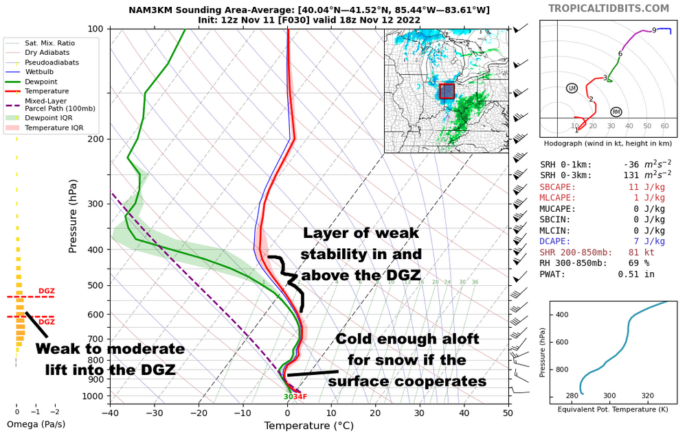
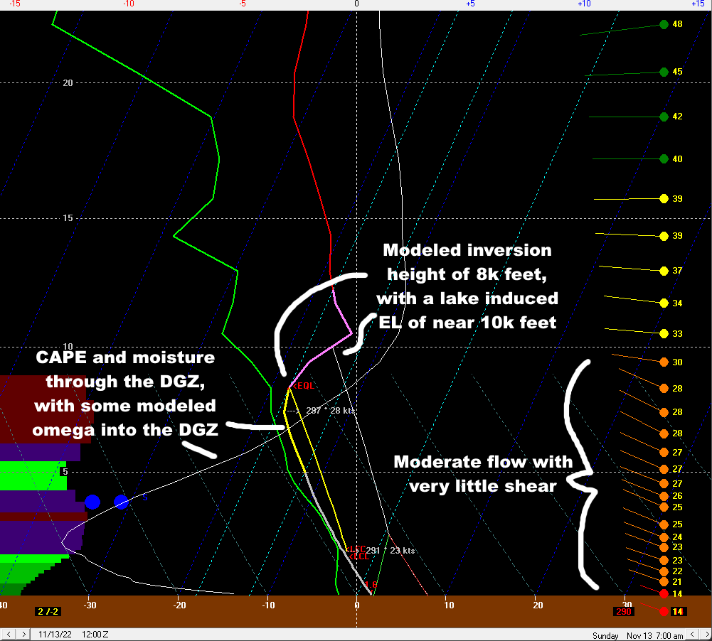
I didn't have 6" of snow on my bingo card for this system...there is small band of mid-level fgen driving the heavier snow, and it is producing its strongest lift in the DGZ so you're getting ratio help. Pretty impressive for the Ohio Valley in the first half of November.
-
1
-
-
On 11/8/2022 at 7:47 PM, raindancewx said:
I'm pretty convinced the cold dumps are going to continue into the West, or at least the Rockies for the next four months. The mechanism(s) for that of course will vary, since the PNA/AO/NAO/EPO/WPO all are basically irrelevant for temps in a correlation sense where I am until early to mid-January. The years I mentioned with the severe NE US heat in cold-ENSO are actually fairly cold nationally in November on balance, and then typically cold in the West, and warmer East. 1938 in particular interests me since Fiona was not that different from the system in 9/1938.
One thing that would bug me about 2010 is the WPO actually. I'm pretty sure it's consistently negative that Nov-Mar year, and there have been lots of pretty powerful lows in the NW Pacific, I'd imagine it's going to finish positive this November, and that often ties in with stuff that happens in the West, Plains and South pretty directly. It really seems to weaken cold in otherwise cold patterns.
By the way: I saw Weatherworks has a winter outlook up without you. I think you should start a new service and call it..."Weatherjerks"
You are little more unique in that you're much more dependent on the sub-tropical jet or cut-off lows for temperatures than a lot of the rest of the U.S...but, I'll be curious to see how the pattern evolves into December. I think we're on a similar page for the next couple of weeks, but I'm more bullish on a -EPO (and perhaps a more workable AO and NAO) returning in December. The WPO is probably going to be slightly negative for this month, or at worst near neutral. It was weakly neutral the first week of the month, is briefly positive now, and looks to trend more negative again for the next 10 or so days. I left WeatherWorks on good terms late in 2021 and am not too unhappy about not having to deal with a winter outlook for my job this year, so they can have at it with theirs!
On 11/10/2022 at 1:31 AM, MattHugo81 said:Thanks for taking the time to post this information...
The blocking signals for the early part of the winter period have been consistent, not just related to seasonal model data, but with regards to the key drivers and teleconnections as well. However, we have all been here before over the years and I fully believe now that LRF is becoming an even more difficult task due to the influences from climate change. We've seen some 'strange' behaviour of the QBO in recent years, while analogues and composites still provide interest I believe it is these which are becoming increasingly unreliable when looking ahead. Perhaps one could suggest that has always been the case, but I certainly believe their usefulness is being counterbalanced by climate change influences.
From a Europe and British Isles perspective it has been interesting to see how the +AAM spike/high GWO phases now have helped to push back a more anticyclonic trend and aiding to maintain the trough over the N Atlantic. The flatter pattern, which you discuss and of which is highlighted well on some of the plots shows this. It is certainly interesting to see one of the highest AAM spikes in nearly a year within a well entrenched La Nina (oceanic) regime. Clearly, at the moment an atmospheric and oceanic disconnect which is interesting in itself. As you also highlight nicely, it does look as though that Maritime/W Pacific tropical forcing will be a key feature of Nov and Dec, perhaps the winter as a whole as well. Having the MJO in phases 5-6-7, overall, will certainly be interesting for early winter period, clearly phases that often promote amplification to the N Hem pattern (https://www.meteonetwork.it/models/mjo/) but clearly this is one piece of the jigsaw.
While N American can often see cold from more muted signals, unlike the British Isles which often needs a far more robust -ve AO and NAO regime, from my experience over the years it is often the development and interaction of the sPV and the tPV that can 'lead the winter dance'. If the sPV becomes a dominant feature and of which links to the tPV then, "9 times out of 10" it is curtains for any sort of meaningful -ve AO and NAO pattern which has been exampled well in the last couple of winters. Fortunately, at the moment, despite an increasingly organised feature, there remains little evidence for any rapid connection of the two.
Also, we need to keep a close eye on the persistent block that is modelled over Scandinavia and potential wave breaking influences down the line as well. A case of 'steady away' for now, but again as you have highlighted well in the original post, there is a lot of hope and also science being this winter being far different than last year, for example and perhaps especially so over the next 8 weeks. The latter half of the winter period would likely transition to a +ve NAO pattern, IMO, at the moment, but clearly that depends on any SSW risk and potential down the line.
Kind regards.
Thanks for your input, Matt!
Many interesting points you raise here. I also am unsure of how old teleconnections or rules of thumb hold up given the influence of climate change. I still think analogs and composites have some use when looking ahead, but you need to mentally adjust for the influence of climate change...which I'm personally still not sure what the influence is...I think it adds another difficulty in long range forecasting. We have seen two odd QBO progressions over the last several years after not really seeing anything like that before, so it is curious to see if that continues happening going forward. It's possible the super El Nino in 2015-16 had at least something to do with that.
Good point that in North America we can get cold from a favorable Pacific even with a lackluster AO/NAO, whereas Europe very much needs the AO and NAO to cooperate. The persistent Scandinavian block you mentioned that's modeled over the next couple of weeks is intriguing for a couple of reasons...it may help cool off eastern Asia, allowing for increased mountain torque down the road, and may have a shot at retrograding towards a -NAO as well. If this aligns with the MJO moving back into the western Pacific in late November, perhaps that's the evolution we need to shake the +NAO? I'll believe it when I see it at this point, but there's reason to be hopeful for the NAO dropping around the end of November or early December.
If we see La Nina and its associated western Pacific uplift last through the winter, I agree that'd point to an increasing risk of a +NAO and mild weather as the winter goes on, especially if we don't see a SSW. I do wonder if the MJO activity we've seen this fall is an indication that La Nina is beginning to lose its grip...if that's the case and we see the MJO occasionally work across the Pacific at a decent amplitude through the winter, perhaps we mitigate any mid-late winter warm spells a bit. I'm not sure yet which way we go with the stratosphere, but as you mentioned it's not coupling to the troposphere for now even though the strat PV is a on the strong side for this early in the season. Perhaps we can see a brief weakening of the stratospheric PV around the end of November/beginning of December if we see a Scandinavian block and Aleutian low at the same time, though the pattern doesn't scream for anything major yet.
3 hours ago, griteater said:@MattHugo81 Matt!!
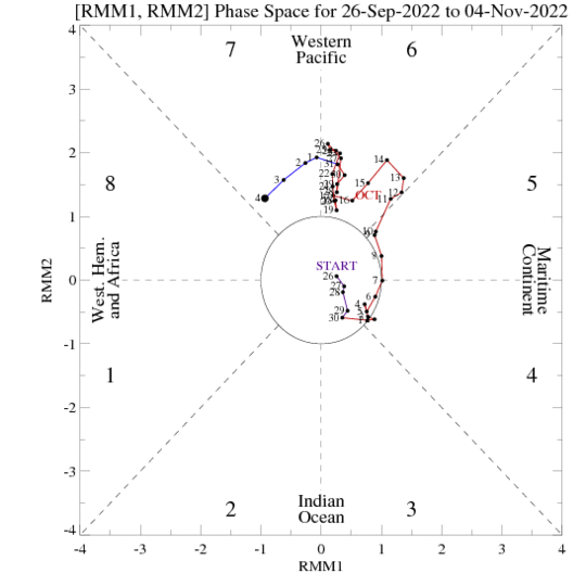
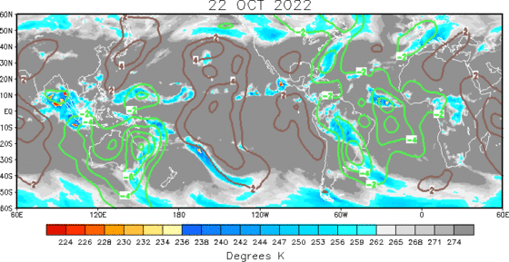
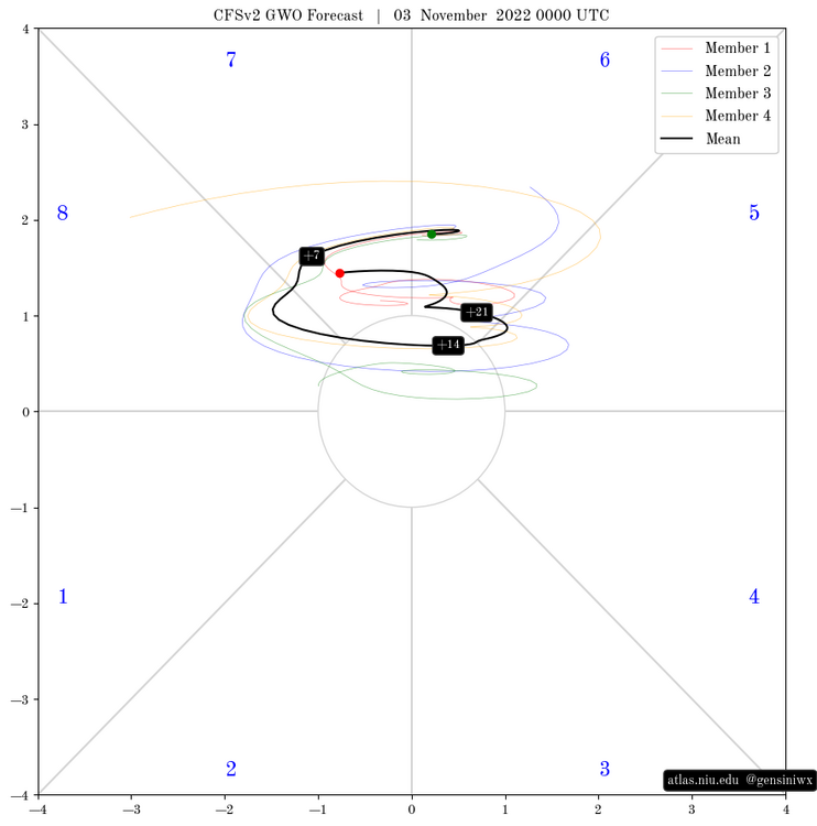
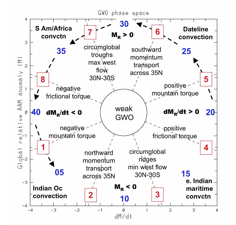
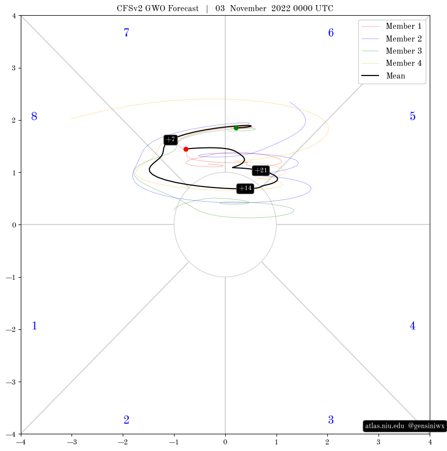
It looks like your thoughts remain on track Jim @OHweather. The -VP is progressing east into Africa -> Indian Ocean, shown here on the 1-day JMA charts over the past week
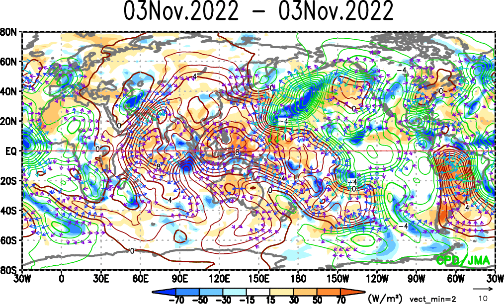
Here is the latest MJO Hovmoller
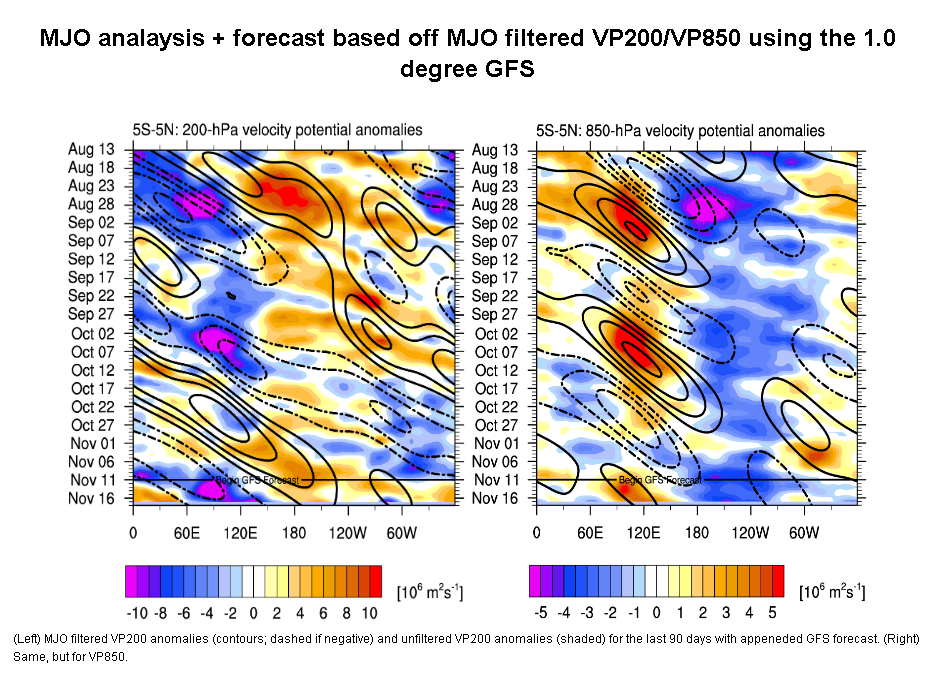
A bit surprising to see projections of the -VP not getting bogged down in the Indian Ocean & Maritime Continent given La Nina, but the MJO speed through the Indian Ocean makes some sense given that we have a negative IOD with some cool SST anomalies there. We'll likely see a slow down in the West Pacific though based on the high octane water there and typical La Nina behavior

At any rate, maybe we see something in the ballpark of these images from late Nov to mid-Dec (or at least a few ideas from these images)....6-7-8 MJO circuit
Nothing on the forecast charts show a pattern for strong Strat PV weakening, but we also aren't seeing any signs of a strong +AO pattern developing in the troposphere....it's middle of the road between the 2 at the moment
Thanks for the added conversation! I remain fairly confident that the general idea for the next few weeks is on track for the reasons you touched on with the MJO. There are also signs that we may see increased mountain torque again later this month, which would support the EPO and PNA improving again and could also help kick the MJO east of the Maritimes if it tries getting stuck there...which would be a similar evolution to what we just saw early this month.
How the stratosphere plays out may have something to say about the rest of the winter, and may even have something to say about if blocking does return to end this month or into December. I agree with you (and Matt) that right now, it's hard to glean much from the stratosphere...I could see another brief stretching event of the strat PV around the changing of the months, but otherwise the strat PV is fairly strong but isn't yet coupling to the troposphere in a problematic way.
-
4
-
-
Definitely a taste of winter arriving this weekend and lingering through at least next weekend. A shot for some flakes Saturday afternoon as a shortwave brings some light precipitation to the area, though surface temperatures are marginal so probably no chance to stick, and this may simply be mainly rain along the lakeshore.
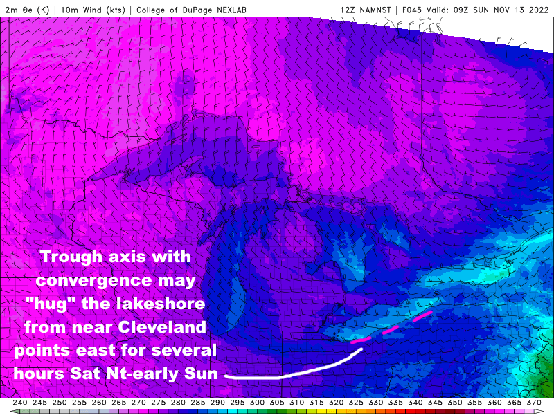
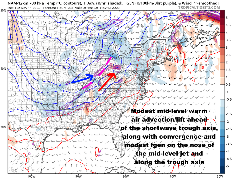
The lake effect set-up Saturday night into Sunday is interesting...a mix of pros and cons...there is briefly good synoptic support with a shortwave, surface trough, and increased moisture pushing across the lake and into the primary snowbelt overnight Saturday night into early Sunday. Expect good convergence near the shoreline from Cuyahoga County points east for several hours Saturday night into early Sunday. At the same time, instability is moderate to nearly extreme off the lake, per BUFKIT, with a very well-aligned flow out of the west-northwest and inversion heights climbing to close to 10k feet.
The profiles are too warm for a good fluffy snow, but expect precip off the lake to change to snow fairly quickly in the hills Saturday evening (if it even rains in the hills at all) and eventually change to mainly snow or graupel even close to the lake by Sunday morning with 850mb temps of -8 to -10C. Locations away from the lake should drop to near, or in the higher terrain just below, freezing Saturday night which will allow the snow to stick if it comes down steadily at all. Along the lakeshore probably stays in the mid to upper 30s, which will limit accumulations there a good bit. The set-up is short duration, with winds turning more solidly WNW into Sunday, likely causing any bands to lose some organization, especially by midday as air temperatures over land start warming up a bit and weaken any lingering convergence near the lakeshore.

Pros: Decent synoptic support/moisture, good instability/decent inversion heights, shoreline convergence favoring focused bands, very little shear
Cons: Warm ground and marginal surface temperatures, especially near the lake but even inland initially, modest snow ratios, and fairly short duration with winds gradually shifting through the event
I think the winds go west-northwest enough that we can see a band develop and hug the Cuyahoga County lakeshore and push east into the eastern suburbs and a good portion of Geauga County, especially towards early Sunday. There's often another band or two that gets into eastern Ashtabula County and Erie County PA in this type of flow. If we do see bands develop in those locations, snow should be intense enough that it could accumulate up to a few inches in the hills, so it wouldn't 100% shock me if eventually an advisory is needed (I am off this weekend so this is not "inside knowledge", just me spit balling)...however, given the limiting factors, anything more than locally a few inches seems difficult, and even the few inches will depend on organized bands developing for at least a few hours.
-
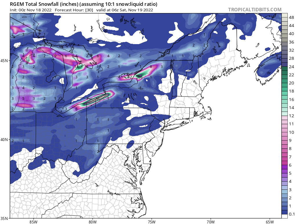
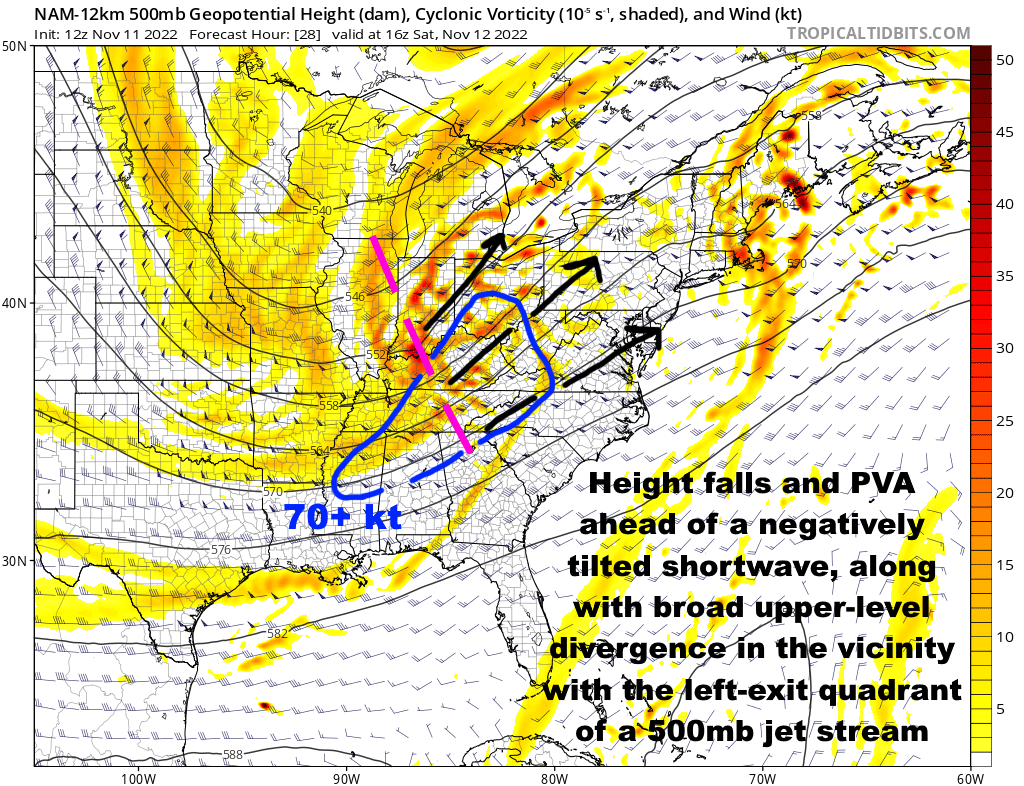
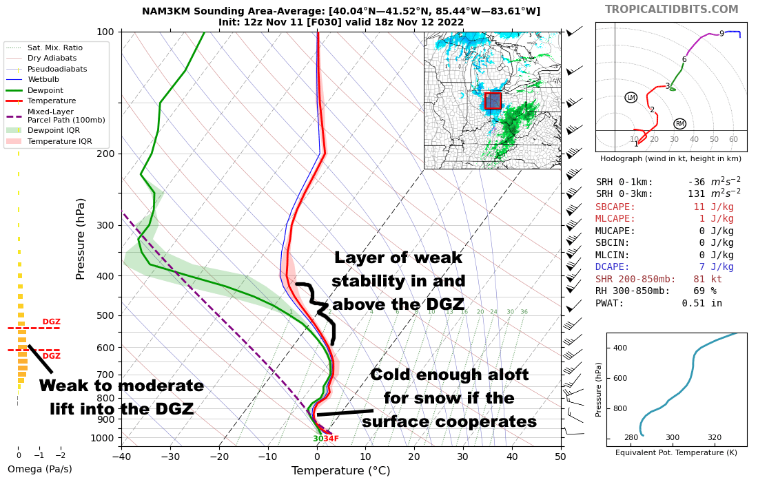
Kind of came out of no where, but a nice negatively tilted shortwave and the lift ahead of it will try to product some snow late tonight through Saturday as it lifts through the Ohio Valley and into the eastern Great Lakes. The lift isn't crazy but it's there, and the somewhat steep lapse rates in and above the DGZ may help some briefly more moderate pockets of precip develop. The main issue, especially farther south/east and especially as we head into the afternoon, will be marginal boundary layer temps, but a good shot many from southern MO/northern AR into southern IL, southern/eastern IN, northern/western KY, and a good portion of OH at least sees flakes out of this late tonight and tomorrow.

.thumb.gif.ce2539ecef230ddaa13771b60f4a85be.gif)
-
3
-
-
It looks like a mediocre lake effect set-up Saturday night through Sunday, perhaps lingering into Sunday night. I could see some spots getting a few inches, but it may be more of a due west or slightly west-southwest flow that keeps things more confined to the I-90 corridor from Lake County points east. But, seems like a chilly couple of weeks so there may be more chances, and I'm still optimistic about December.
-
On 11/6/2022 at 8:23 PM, raindancewx said:
My issue with using 1996-97 was how rapidly that year collapsed into the big 1997 El Nino. By early 1997, the subsurface was super warm, and you got some real interesting patterns, since it was developing from east to west. I wanted to use that year. But I don't quite trust how it played out, it's been different enough that I threw it out.
A lot of the cold-ENSO years with similar early November heat waves for the NE US are kind of interesting - 1938, 1948, 1959 were years I saw today for similar Boston heat.
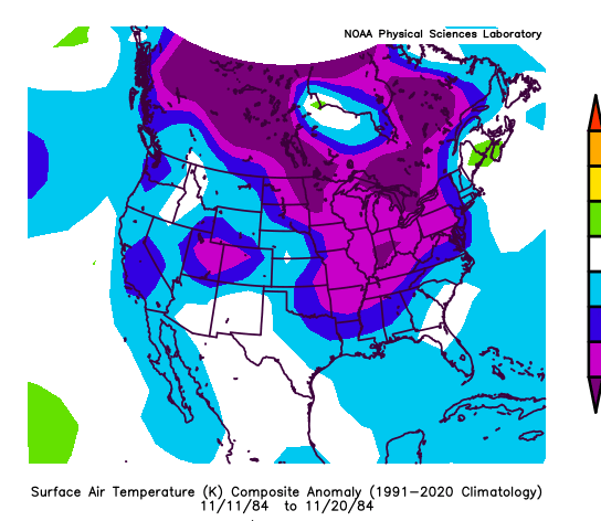
I tried to pick Fall years that had major heat and cold waves. I know 2016/2020 were both very warm early November among my group, and then 1984, 2011, 2020 got pretty cold mid-month. Mid Nov 1984/2011/2020 is actually pretty decent for how mid-month will look as the cold drains into the US.
1984 goes to this, but still manages to be pretty warm in December in the east as an example for how I see it playing out. The purples are -5 (light) and -7 (dark) in degrees Fahrenheit. My gut is once the hurricane hits Florida, you'll see some stuff evolve differently on the models for late month and beyond.
Thanks for your insight as always. I do see your point of contention with 1996-97, as this will not be going towards any kind of a strong, east-based El Nino anytime soon. That said, the La Nina is starting to lose its grip, evidenced by the MJO activity we are starting to see, so that's why I think it may be somewhat useful as an analog.
I am curious to see how this month looks when it's in the books...while the early month heat is indeed very impressive in the east, and will be hard to overcome on the monthly mean, the rest of the month will be much colder in the central and eastern U.S...many of the years you mentioned were chilly/cold in the west and anywhere from mild to very warm over the east in November, with a large +EPO/trough over Alaska. While this month is starting mild, we're really avoiding that ++EPO look, and probably will have a negative EPO for the month of November overall. So, I'm curious to see if that leads to my colder December idea still having a shot when the analogs you mentioned are much bleaker for the east (but are somewhat more interesting for the west). If we see another strong MJO event to end this month and into early December, I'd be rather surprised to see any kind of +EPO stick around for long, even if it does briefly flip positive after Thanksgiving.
-
1
-
-
Not a "winter forecast" per say, more like a sh*tload of speculation about the pattern through the first ~half of winter...
The Key Points Up Front:
- The pattern of “cold west, warm east” continues through most of this week
- Later this week into this weekend, cold spills into the central and eastern United States. The pattern then remains fairly chilly across the Lower 48 for a couple of weeks, with the coldest overall conditions across the northern Rockies and northern Plains
- Several signs point towards the weather pattern in much of the continental United States trending mild yet again towards the end of November and early December
- A few analogs and early signs in extended guidance suggest the potential for increased high-latitude blocking and colder weather may return into December. Given the ongoing La Nina and -PDO, confidence in this occurring isn’t high yet. However, the coldest December since at least 2016 is distinctly possible if things align properly
The Details:
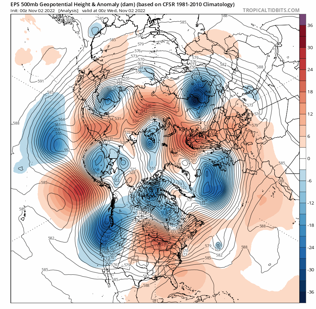
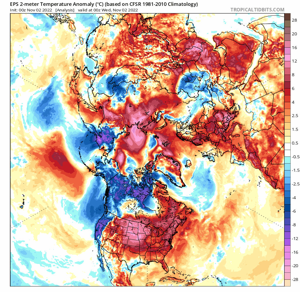
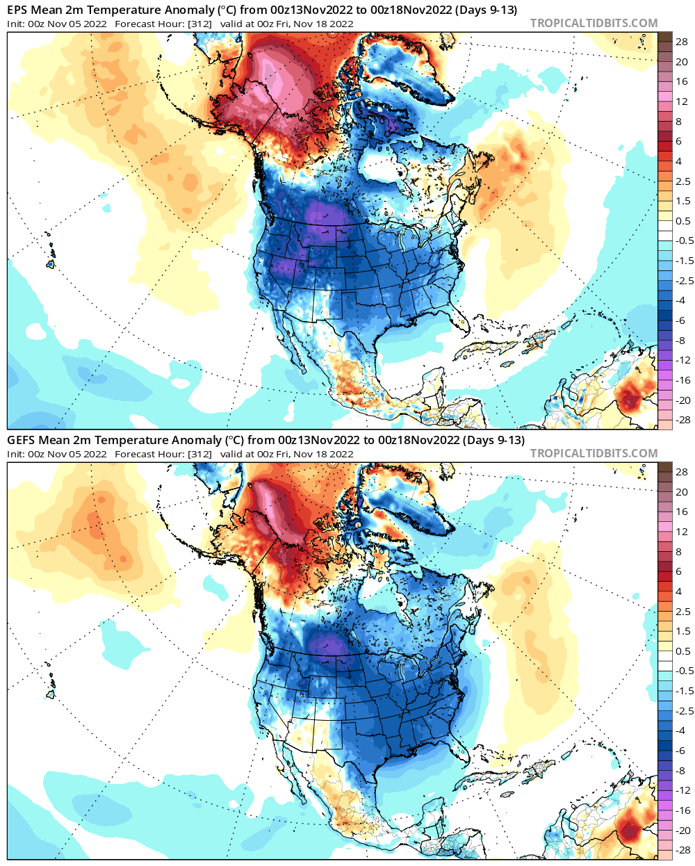
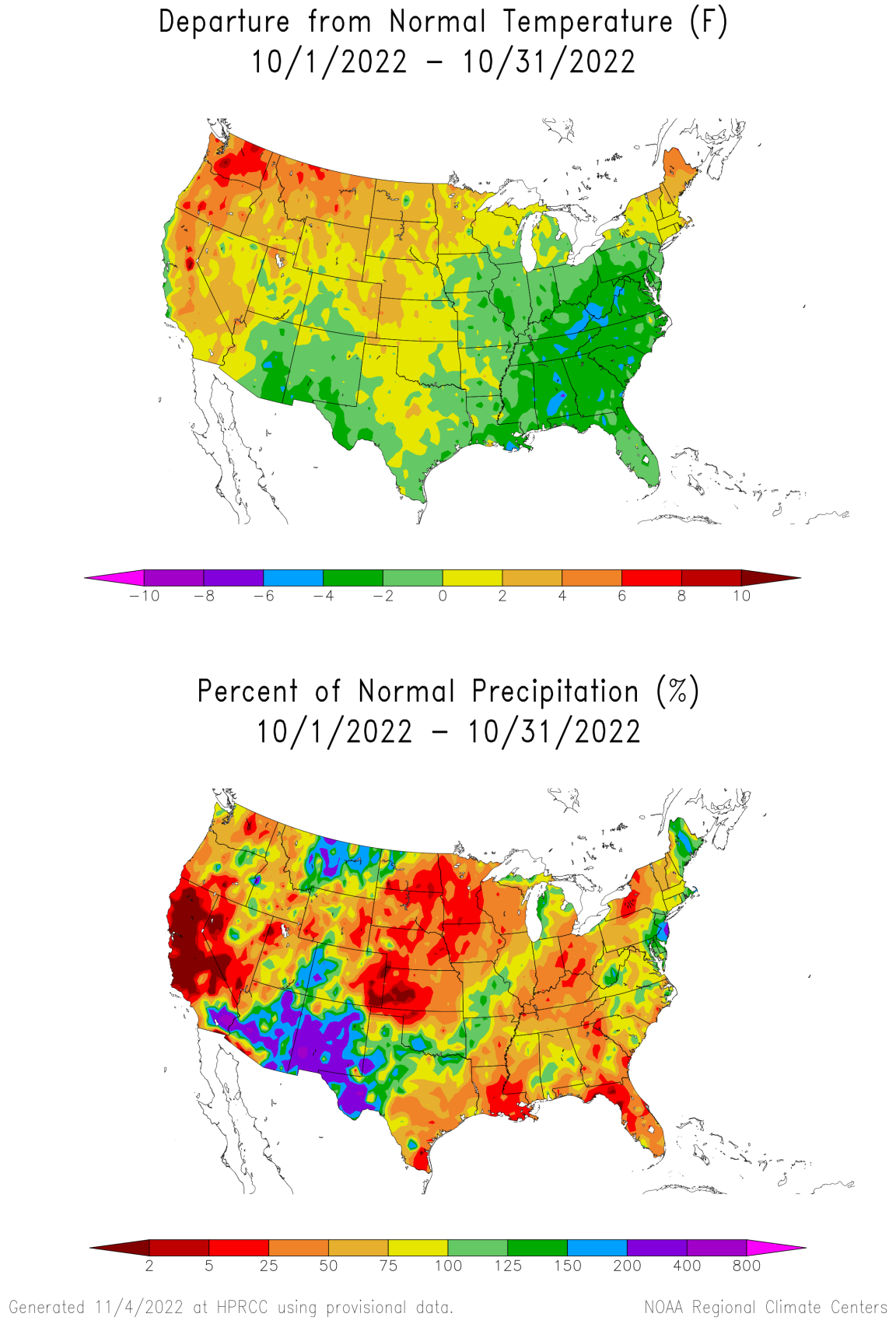
After a very chilly first half of October, which was enough to plunge most of the eastern U.S. to below normal values for the entirety of the month, mild weather has dominated the pattern over much of the central and eastern U.S…this pattern continues into this upcoming week, but the GFS and Euro ensembles both indicate below average temperatures over fairly decent stretch for almost the entire CONUS closer to mid-month:
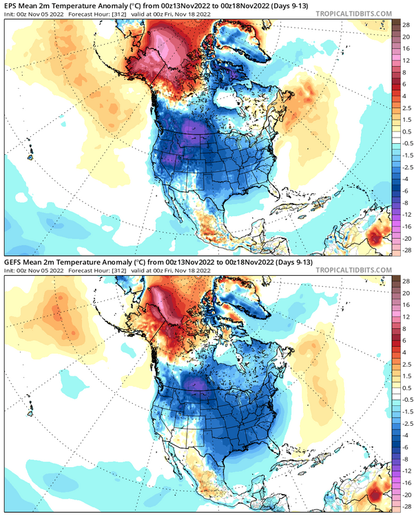
It’s getting to be the time of year where colder anomalies have some more bite and can start bringing snow to more of southern Canada and the Lower 48. This cooldown has trended more and impressive as it moves up in time on the models, evidence by this GFS ensemble trend loop for the same time period:
.thumb.gif.7615a62aa3d2fb927bb2028c654cfecc.gif)
After such a prolonged mild spell, is this cooldown shown in the medium to long range feasible, and how long may it last? Looking at a few things, including the character of the Pacific jet stream and the MJO, suggests that the projected cooldown on the ensembles has legitimacy. Let’s start with the pattern over the last week leading up to Friday:
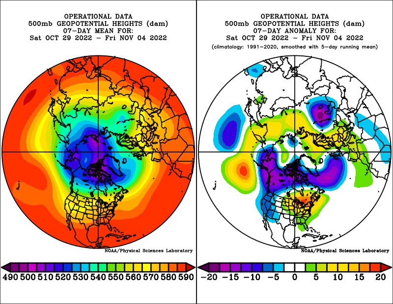
The pattern is undoubtedly a warm one for the central and eastern CONUS and into southeastern Canada, with a positive AO (PV generally tight and confined to the high latitudes), a very positive EPO (the trough over Alaska and western Canada), a negative PNA (Aleutian ridge and West Coast trough), and positive NAO (trough over the north Atlantic).
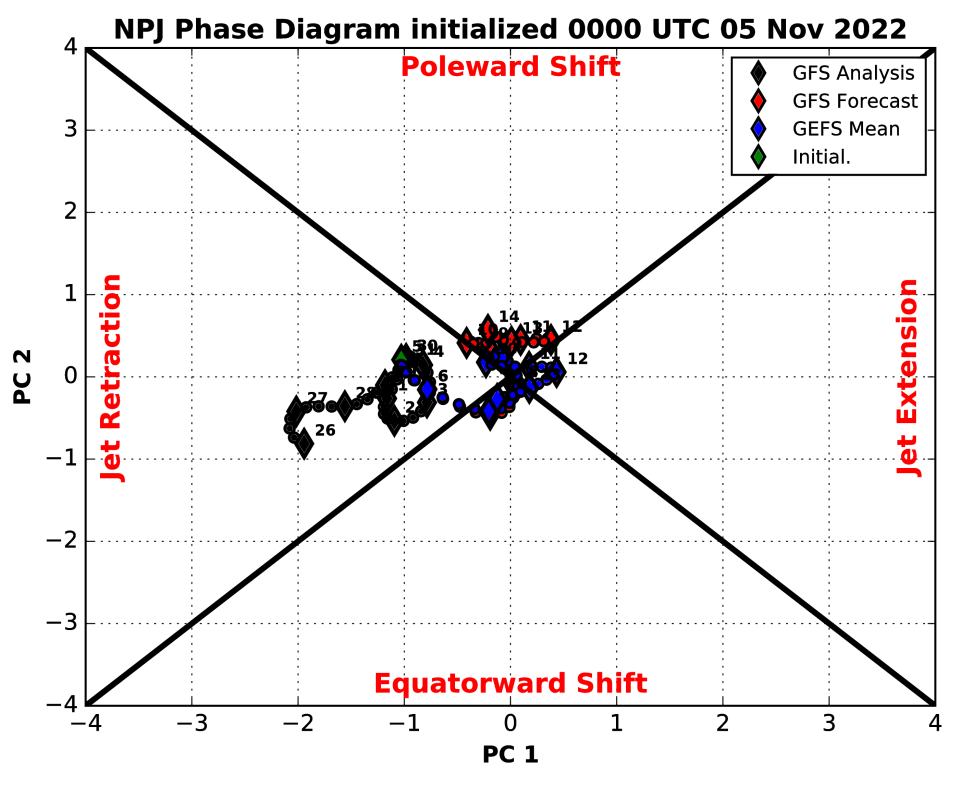
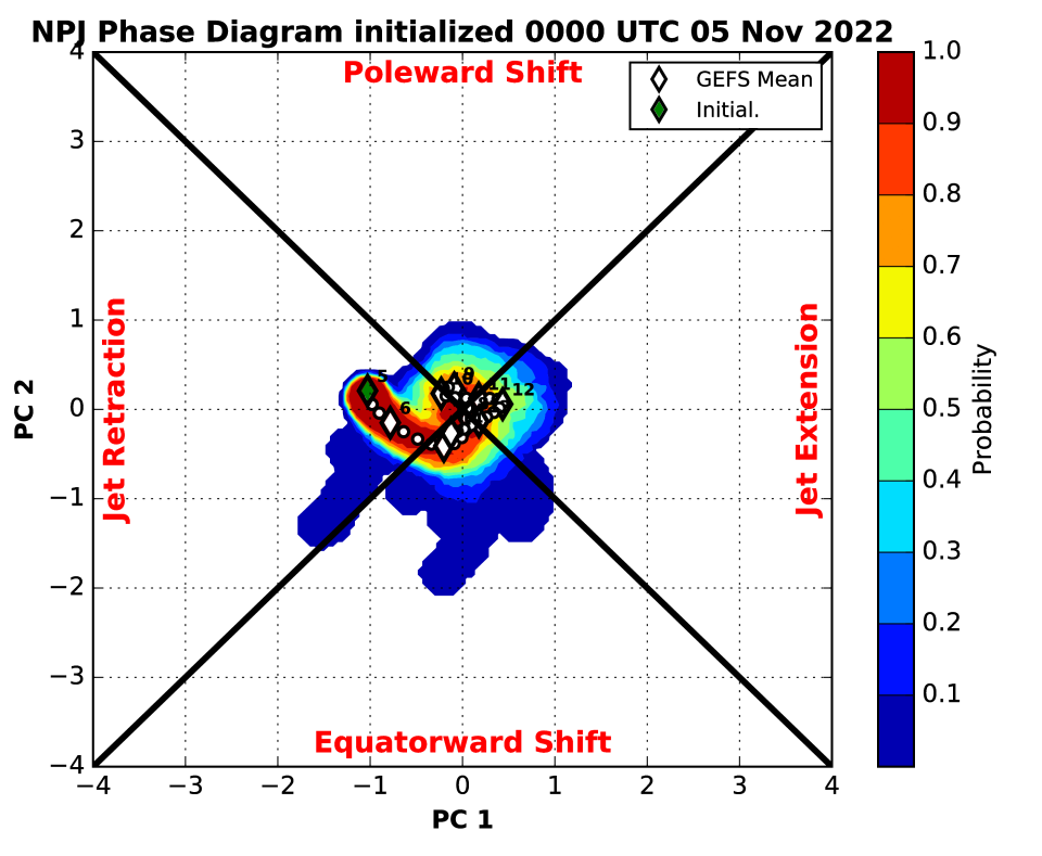
The above pattern correlates very nicely to the expected pattern when the Pacific jet is retracted, as it has been most of late October and very early November per the above chart:
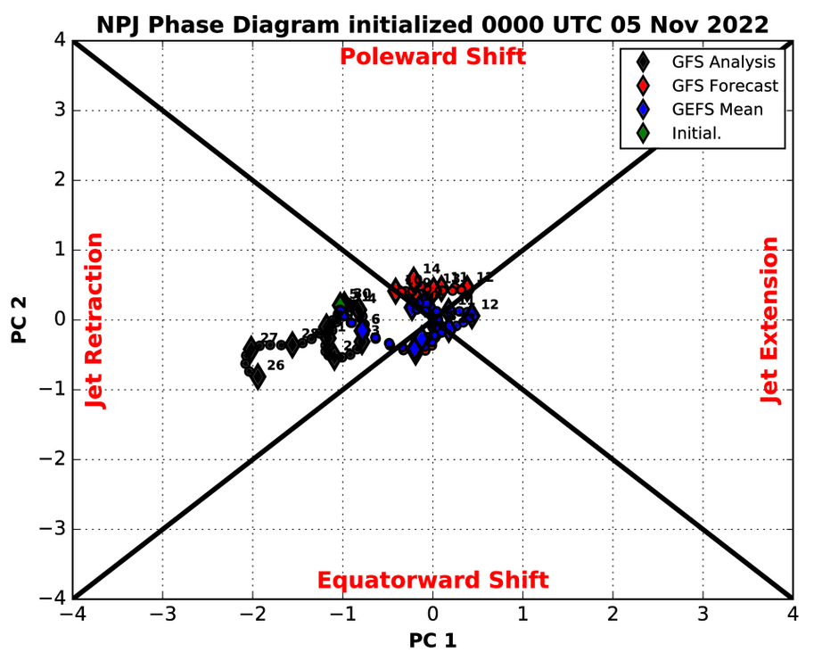
The flat ridge south of the Aleutians, trough over Alaska and western Canada/the western US, and downstream ridge over the eastern US are quite characteristic. There are a couple of ways to analyze how the Pacific jet is progged to behave on current guidance over the next week or so…one is just to throw in a loop of ensemble mean forecast 250mb winds:
We start off in the middle of last week with a “jet retraction” look, with the jet barely extending off of Asia and a ridge over the Aleutians, directing the jet stream towards Alaska and the northwest coast of North America, helping facilitate the current very mild pattern across a good portion of the Lower 48. However, quite a bit of westerly momentum is getting added as I type this and into early this week. Initially, the ridge near the Aleutians just amplifies and disperses a lot of this added momentum around it, but eventually the jet extends and pushes the now-amplified ridge east, facilitating cross-polar flow into North America and really cutting off the Pacific influence by this upcoming weekend. Here is the GEFS forecast Pacific jet character:

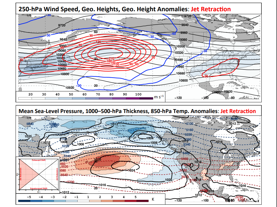
A similar trend, from a pronounced jet retraction in late October towards neutral, with perhaps some modest lean towards an equatorward shift or jet extension over the next week or so. Here are what a Pacific jet extension or equatorward shift tend to look like:
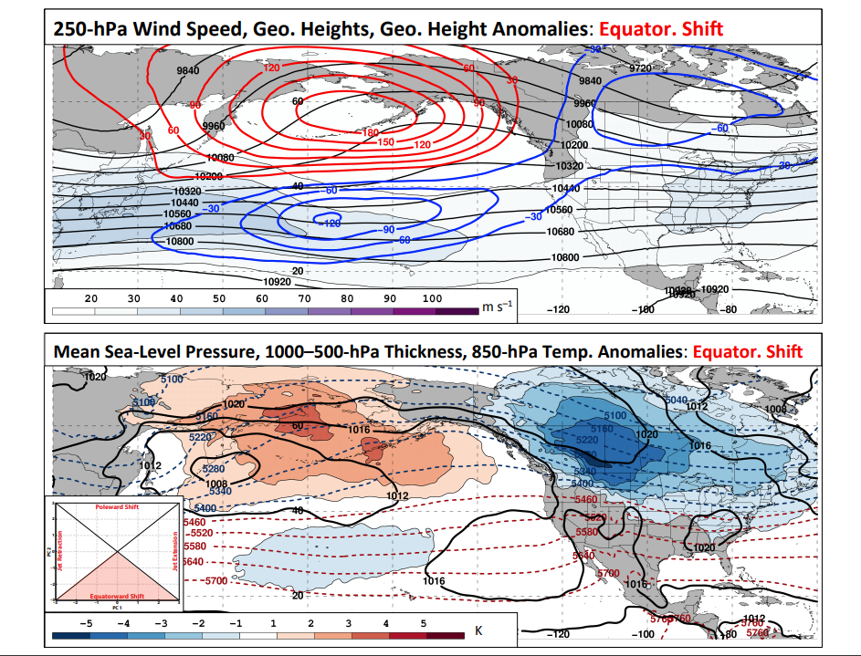
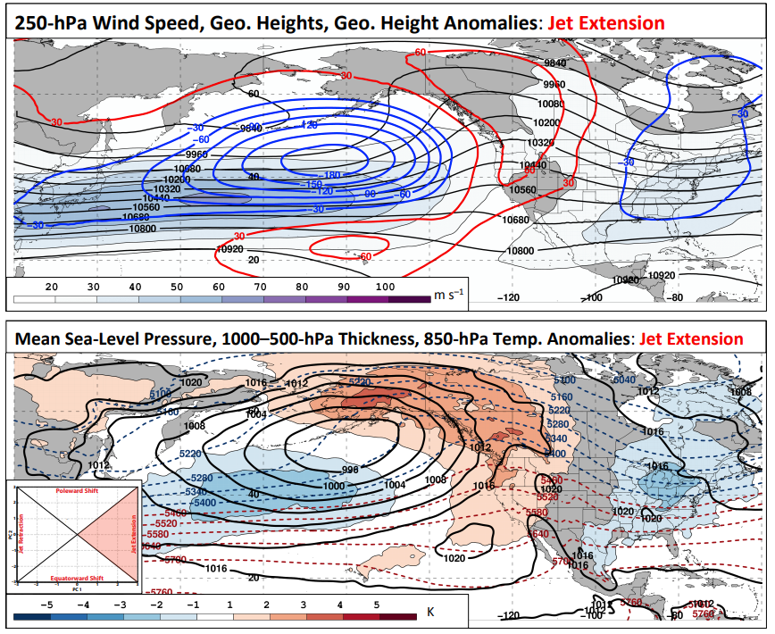
Note the trend towards much higher heights into the northern Pacific and Alaska, with resultant troughing and colder weather over a good portion of North America…in particular, over western and central Canada into the northern Rockies and Plains with an equatorward shift, but bleeding towards the East Coast. The equatorward shift looks more like a -EPO but still somewhat negative PNA, while the jet extension looks more like a classic +PNA with a somewhat negative EPO. This generally matches the ensemble’s forecast pattern over the next week or so:
The impetus for this change seems to be a combination of increased east Asian mountain torque and tropical forcing working out of the eastern hemisphere and into the western hemisphere early this month. Initially, the pattern this weekend into the first half of the week simply looks like a significant amplification to the going pattern:
At first, we just see the ridge south of the Aleutians amplify, which amplifies the downstream pattern over North America (western trough and eastern U.S. ridge). However, this very mild look over the eastern U.S. doesn’t last too much longer as the ridge amplifies into Alaska, forcing cold south towards the CONUS, and as an Aleutian low develops. An Aleutian low is a trend towards a more positive PNA.
Note positive MSLP anomalies (high pressure) dropping into eastern Asia right around now, signifying a significant increase in east Asian mountain torque, which results in added westerly momentum to the east Asian-Pacific jet. There may be another push later this upcoming week, before a fairly well agreed upon trend towards a much more negative east Asian mountain torque into mid-November:
Positive East Asian mountain torque tends to result in an extension of the Pacific jet and subsequent rise in the PNA, as the extended jet and associated left-exit region towards the north-central Pacific tends to favor low pressure over the northwest Pacific or Aleutians and subsequent height rises to the east closer to the West Coast of North America.
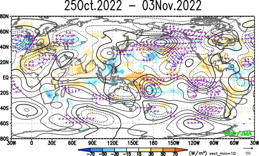
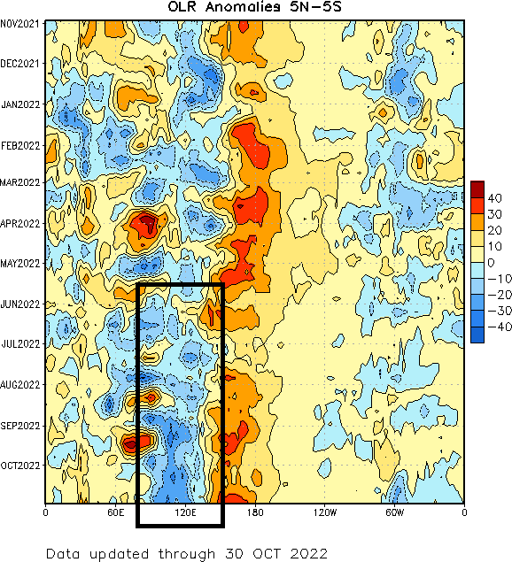
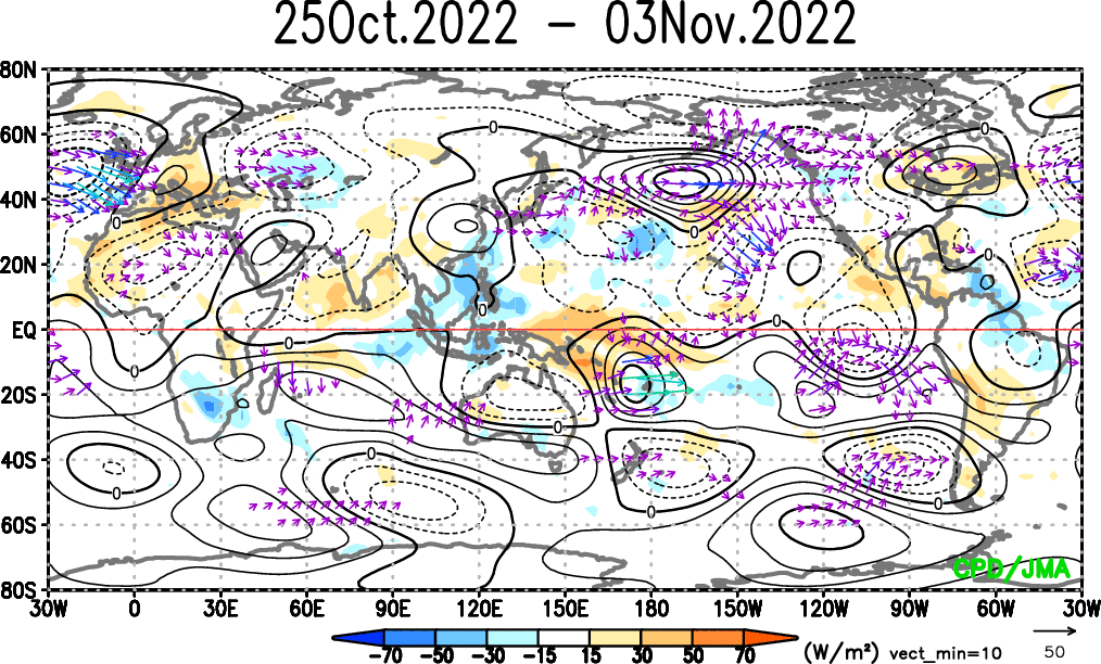
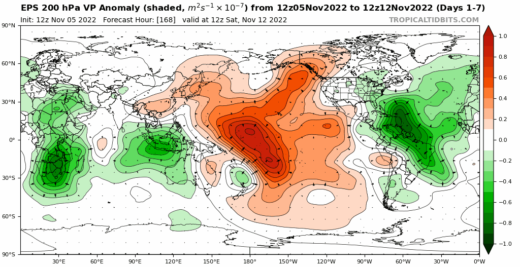
At the same time, the MJO has come out of the Maritimes and into the western Pacific at a fairly high amplitude, and is now quickly working into the western hemisphere. The satellite/VP anomaly loops over the last two weeks show a similar trend as the above RMM plot, with strong uplift over the western Pacific until the end of October quickly shifting east. Note how areas that had the strongest upward motion (~120E) at the beginning of the loop have strong sinking motion now, and vice versa over portions of the central and eastern Pacific. Clearly, the tropical forcing is changing from the forcing that led into our current very mild pattern.
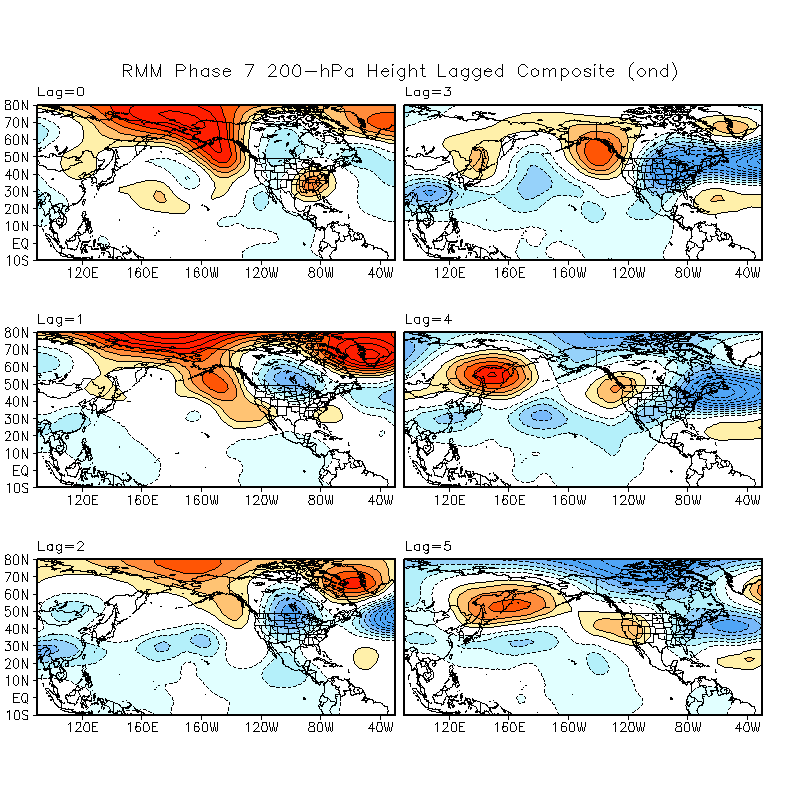
After a decent Phase 7 passage, an increase in blocking near Alaska in October-December is quite common:
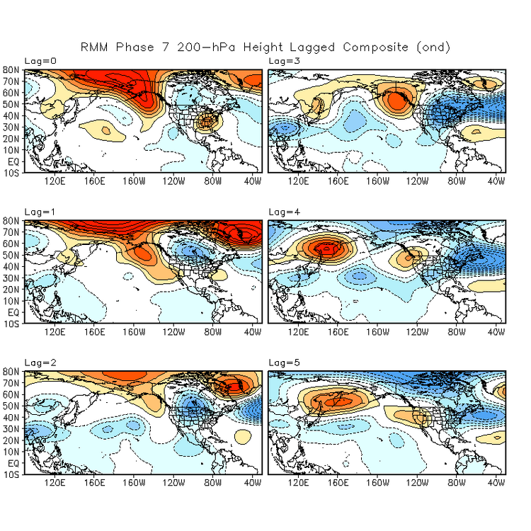
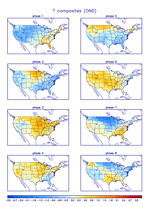
We are not going to get the NAO help in the short term, but blocking located near Alaska/a -EPO is often common during and following a phase 7 MJO this time of year as seen above. The MJO is about to briefly get into Phase 8, which also often leads to a colder outcome into the southern and eastern U.S. than a Phase 6-7 in the fall:
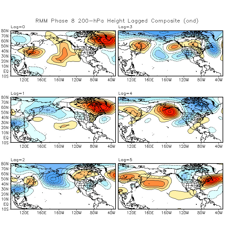
And for what it’s worth, the same October-December lagged composites from the CPC for a phase 8 MJO, which is briefly occurring right now:
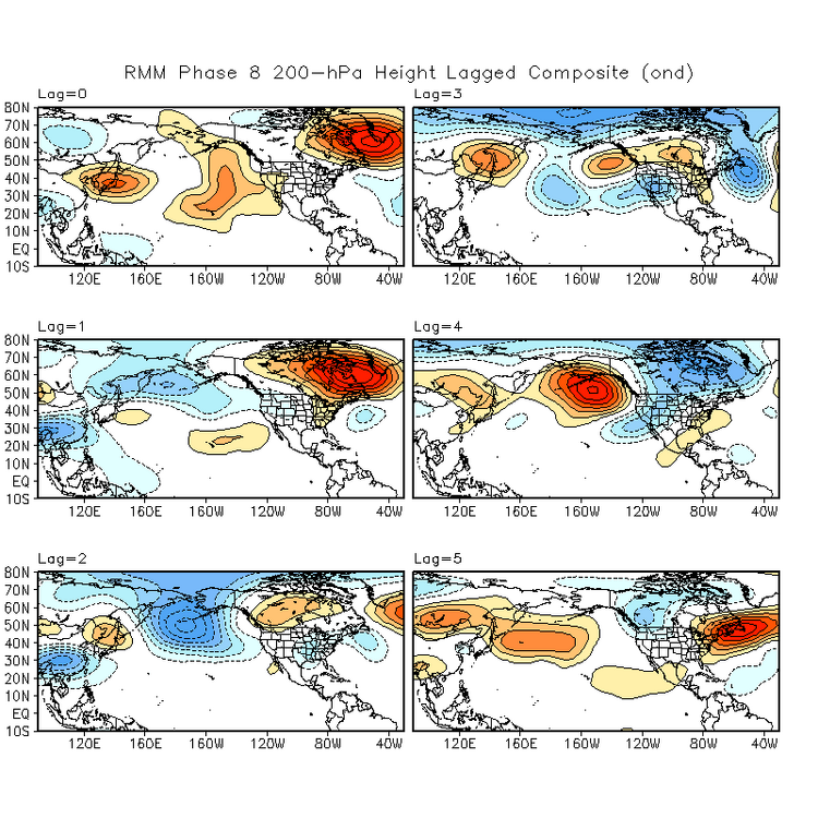
The issue with these is that the pattern right now into this week, which would be a “Lag=0” for the current phase 8 RMM indication, is that the NAO is quite positive with a deep trough out west. That said, a phase 8 MJO this time of year often corresponds to immediate and short term blocking, with an Aleutian low/+PNA and colder trend over most of North America. This is then followed by the PNA trending more negative and blocking generally breaking down within a few weeks of the phase 8 MJO occurring.
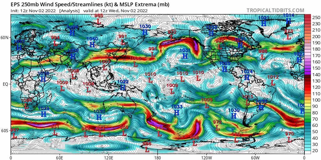
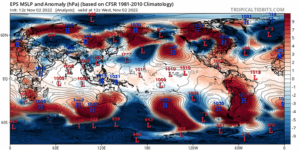
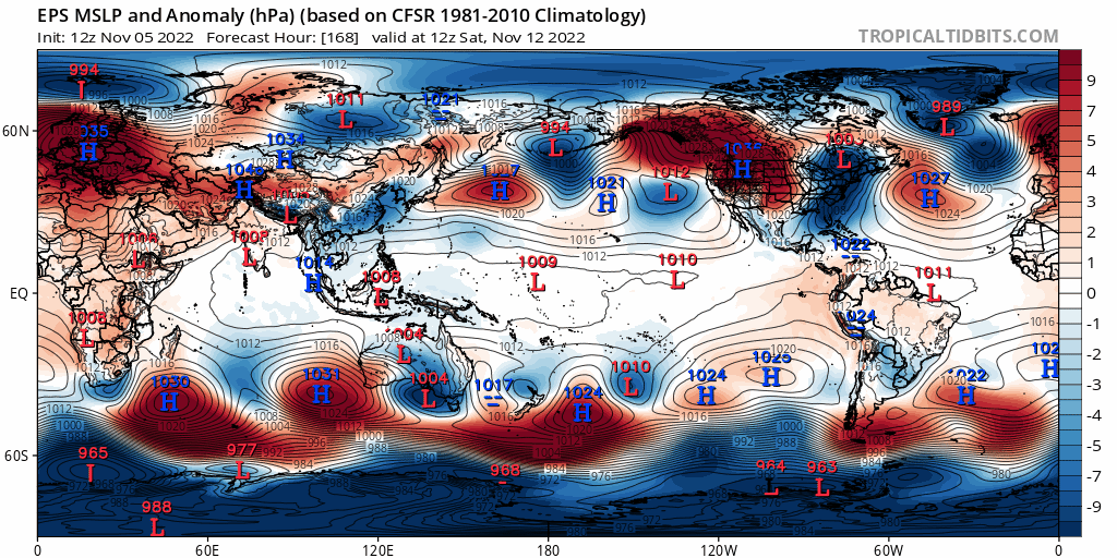
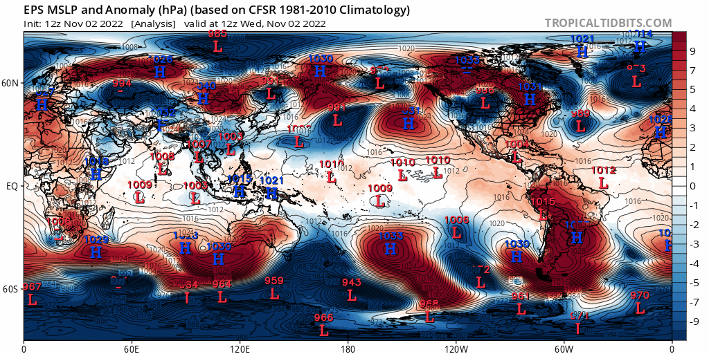
Despite the phase 8 MJO pointing to a -NAO, I am fairly confident it will remain positive for the next 10-15 days. This is because the stratospheric PV, while getting stretched a bit at times, is going to remain on the stronger side of normal, which argues towards a +NAO for now. In addition, recall back to this EPS mean sea level pressure/anomaly loop:

Note multiple high pressure systems dropping in just east of the Rockies over the next 10 days. The Rockies are not quite as tall as the Himalayas, but they’re still plenty tall enough to produce a mountain torque that requires increased momentum in the jet stream to conserve angular momentum in this equation (the positive mountain torque removes momentum by slowing Earth’s rotation slightly). This speeds up the jet over the eastern U.S. into the North Atlantic, encouraging positive NAO trends. Given that the NAO has been positive since late October, I don’t see it flipping negative in the face of this through at least the middle of November.
Looking Beyond Mid-November:
A dramatic shift to a colder pattern in the CONUS, first into the Pacific Northwest over the next few days and then expanding into the rest of the CONUS through next weekend and through mid-November is agreed upon by the major ensembles and seems very well-supported by various forcing mechanisms…driven by a plunging EPO and rising PNA. But how long will it last, and does it mean shit for the approaching winter season as a whole?
To answer the first part of this question, we will examine things such as mountain torque and tropical forcing yet again. Starting with mountain torque, and picking up closer to mid-November, after our upcoming increase in mountain torque and injection of westerly momentum into the Pacific jet:
Positive east Asian mountain torque is ongoing at the start of the loop, but as low pressure develops over much of southeast Asia, this becomes negative, reducing westerly momentum into the Asian-Pacific jet around mid-November. This suggests the jet will have a tendency to retract again, which would render the upcoming PNA spike brief and could eventually cause the EPO to start trending more positive again.
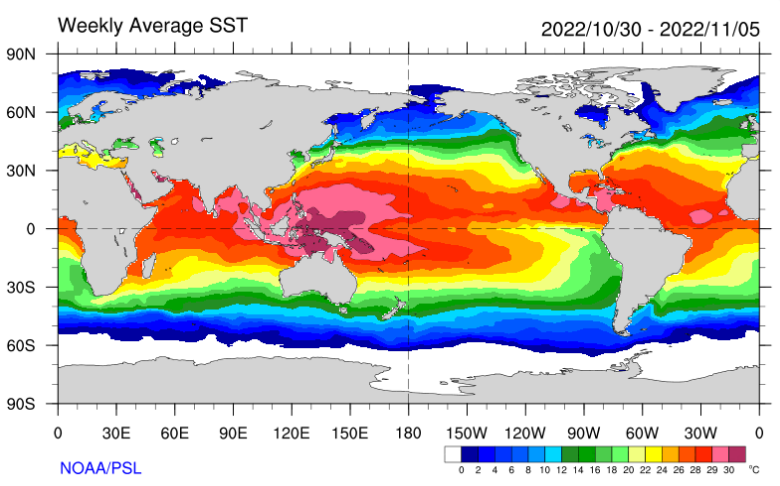
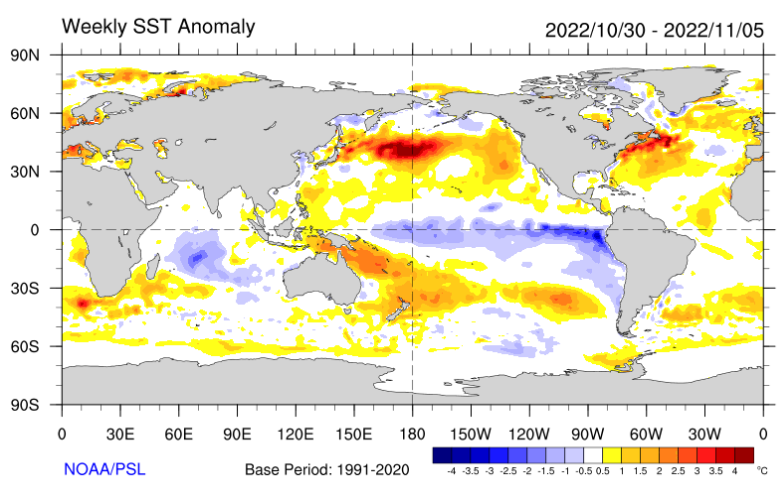
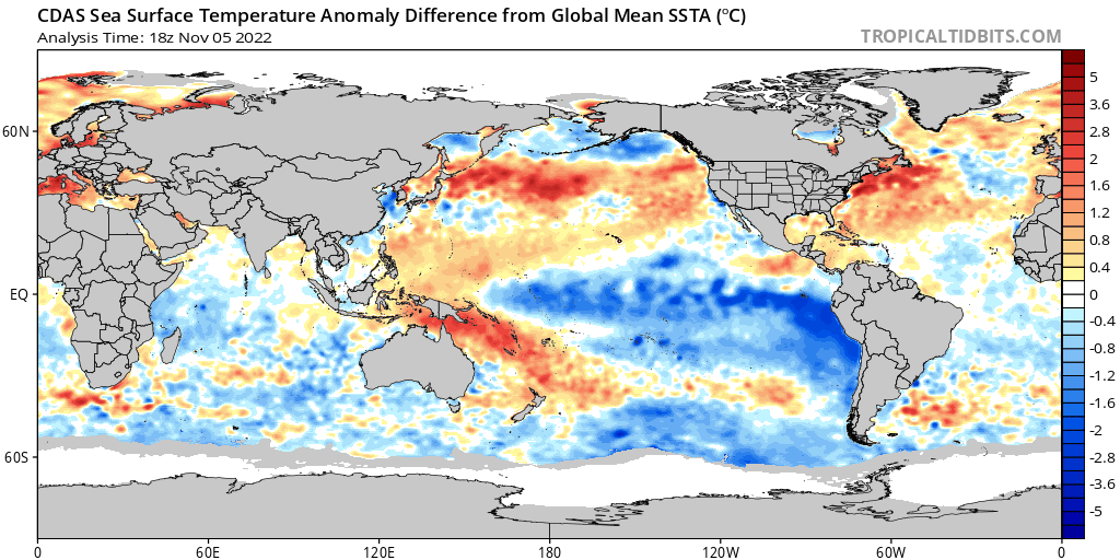
Remember, we are in a La Nina with a solid -PDO, evidenced by the cool tongue across the equatorial Pacific, the warm waters over the northwest Pacific, and the cool waters south of Alaska:
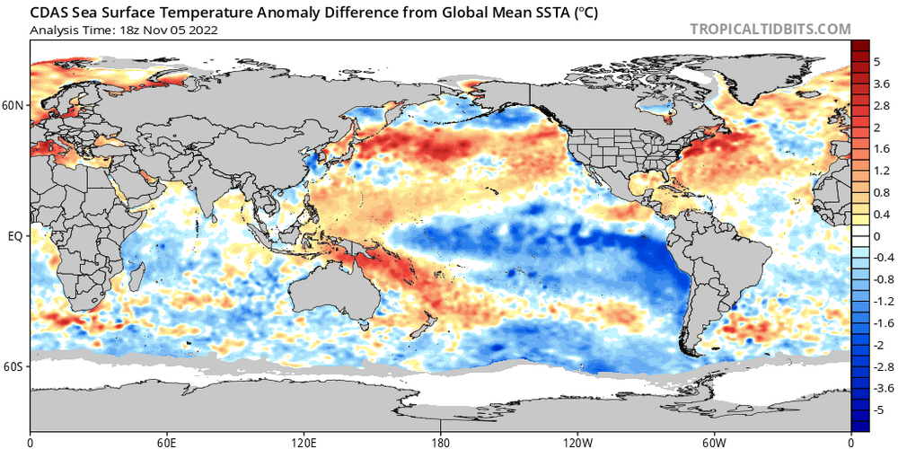
These both favor a -PNA and often favor a predominantly +EPO as well. We look to buck that over the next week due to tropical forcing progressing through the Pacific and Western Hemisphere and due to a positive east Asian mountain torque, but when those shorter term pattern drivers subside, the lower frequency forcing can often dominate yet again. So, the expected negative east Asian mountain torque towards mid-November is a signal that a more -PNA and more neutral EPO is a distinct risk into the latter portions of November given the background forcing.

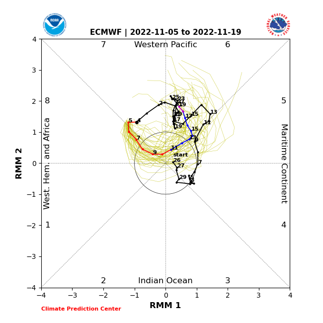
Most guidance (the European ensemble shown above) suggests tropical forcing quickly progressing through the western hemisphere over the next week or so, with eastern hemispheric forcing (in particular, over the eastern Indian/western Pacific oceans) becoming dominant once again towards the second half of November. Given the background state, this seems very plausible after the current higher frequency forcing moves through the western hemisphere in the shorter term. RMM forecast plots also indicate similar, with the ongoing Phase 8 MJO not lasting long and then becoming “indeterminant” (which usually means lower frequency forcing can exert more influence again). Thereafter, the MJO may move into phases 5 or 6 after the 15th. Here is the European ensemble forecast MJO progression through November 19th:
Recalling back to the above October-December MJO phase temperature correlation plot above, phase 6 is quite mild in the CONUS. This general evolution (eastern Indian/western Pacific Ocean tropical forcing becoming dominant again into mid-November) is well agreed upon by various medium to long range forecast models/ensembles. In addition, the water temperatures support convection and tropical forcing wanting to favor this general region again, as does where enhanced convection/upward motion has been most persistent in recent months near the equator:
So, the background pattern suggests a risk for a retracted Pacific jet and -PNA/+EPO to return when other shorter-duration forcing weakens. In addition, there’s fairly consistent indication that the shorter-duration forcing (mountain torque, MJO) will weaken and may in fact positively feedback with the “background” La Nina pattern into late November.
There’s enough support for a significant cooldown that it will take some time for milder weather to return, we’ll probably have a full 1-2 weeks of generally cold conditions (for this early) across the CONUS. However, many indications are that milder weather gradually returns from west/southwest to northeast in the second half of November.
In terms of snow potential over the next few weeks, the higher elevations over much of the western U.S. (outside of perhaps the Four Corners and southern California) will remain cold and active through this week with a -PNA and dropping EPO. As the cold ejects east late this week, a lee cyclone may bring snow potential to the northern Plains and Upper Midwest. Thereafter, it looks like a fairly dry EPO-induced cool/cold shot into the central and eastern CONUS. Not all hope is lost, as some snow may occur via lake effect, weak clippers, or perhaps any waves riding along the baroclinic zone if the sub-tropical jet isn’t totally quiet. Likely not a pattern that supports a widespread, major winter weather event (especially in November), but it’s possible some minor or localized snow events occur outside of the mountains starting this upcoming weekend and through roughly Thanksgiving.
Some Fun With ENSO/MJO Analogs:
The rest of the winter is not yet lost though. In fact, the findings discussed below are what prompted me to make this whole thing a post instead of a Tweet thread. I just thought “there’s a lot here, let’s try to tie it together better than intentionally cryptic Tweets would”.
This much MJO activity in the fall leading into a La Nina isn’t too common. Since 1975, only 4 La Nina Novembers saw the MJO move into both phases 7 & 8 at an amplitude of greater than 1. Those are 1996, 2000, 2010 and 2016. Oh, there’s that fabled 2010-11 analog. We also have a very negative IOD and solidly westerly QBO. Let’s see if we can leverage those high-confidence, long-duration pattern drivers. We have a negative IOD this fall and will have a westerly/positive QBO through this winter, full stop.
2010 and 2016 had a westerly QBO
1996, 2010 and 2016 had a negative IOD
How did those 4 years play out during December?
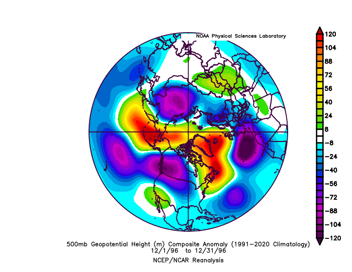
All but 2010 had a solid -EPO, and 2010 still had very pronounced north Pacific ridging along with a a huge -NAO. All but 2016 had a -NAO. All but 2000 had a -PNA. All but 2016 had a -AO. Here is a look at the October-February monthly temperature and precipitation anomalies for these years (weighted slightly based on QBO/IOD matches):
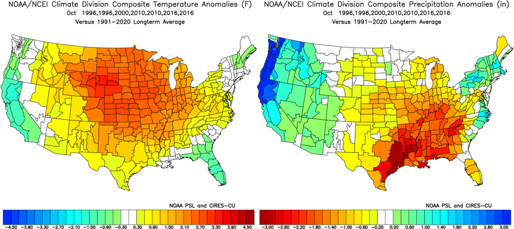
For reference, here are October’s temp/precip anomalies:
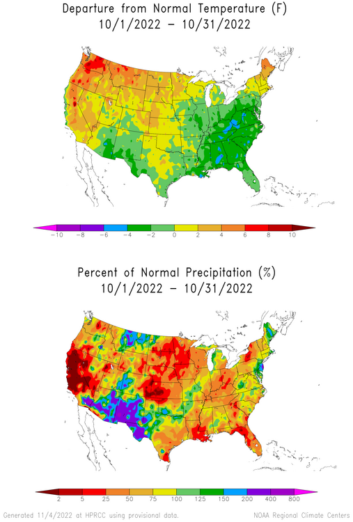
Overall, the October pattern this year actually resembles those analogs, though with the pattern seemingly shifted west slightly. The very warm start to November likely dooms the eastern U.S. to finish with a somewhat mild overall month, but the pattern after this week may resemble these years in November fairly well. It’s at least in the ballpark enough that these analogs aren’t immediately invalid.
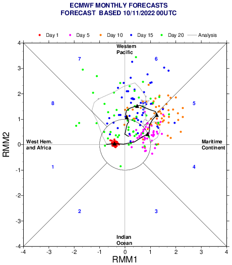
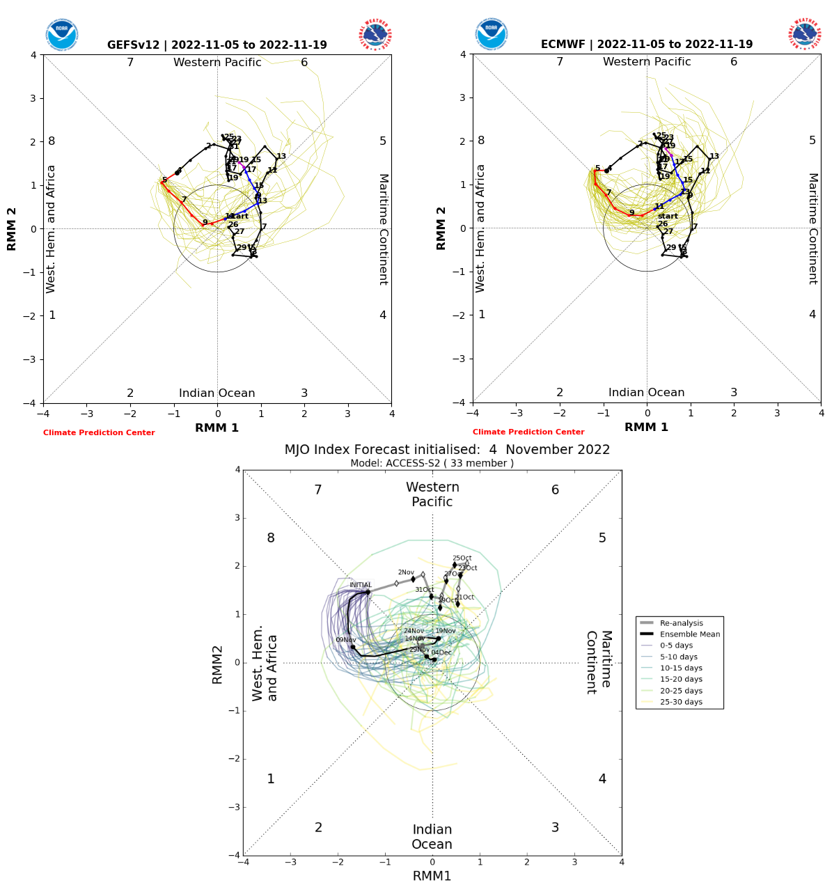
I believe how the MJO and mountain torque play out during late November and into December will heavily influence if the potential for a very blocky, cold, active December comes to fruition given the risks for a milder pattern (at least temporarily) returning by the end of November. Just looking at some various products, the EPS (already shown), GEFS, and Australian BOM MJO forecasts:
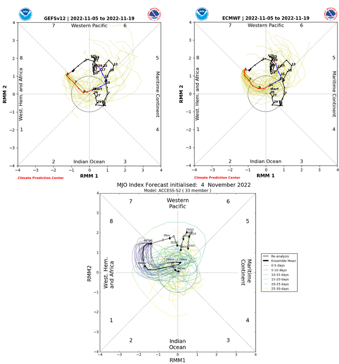
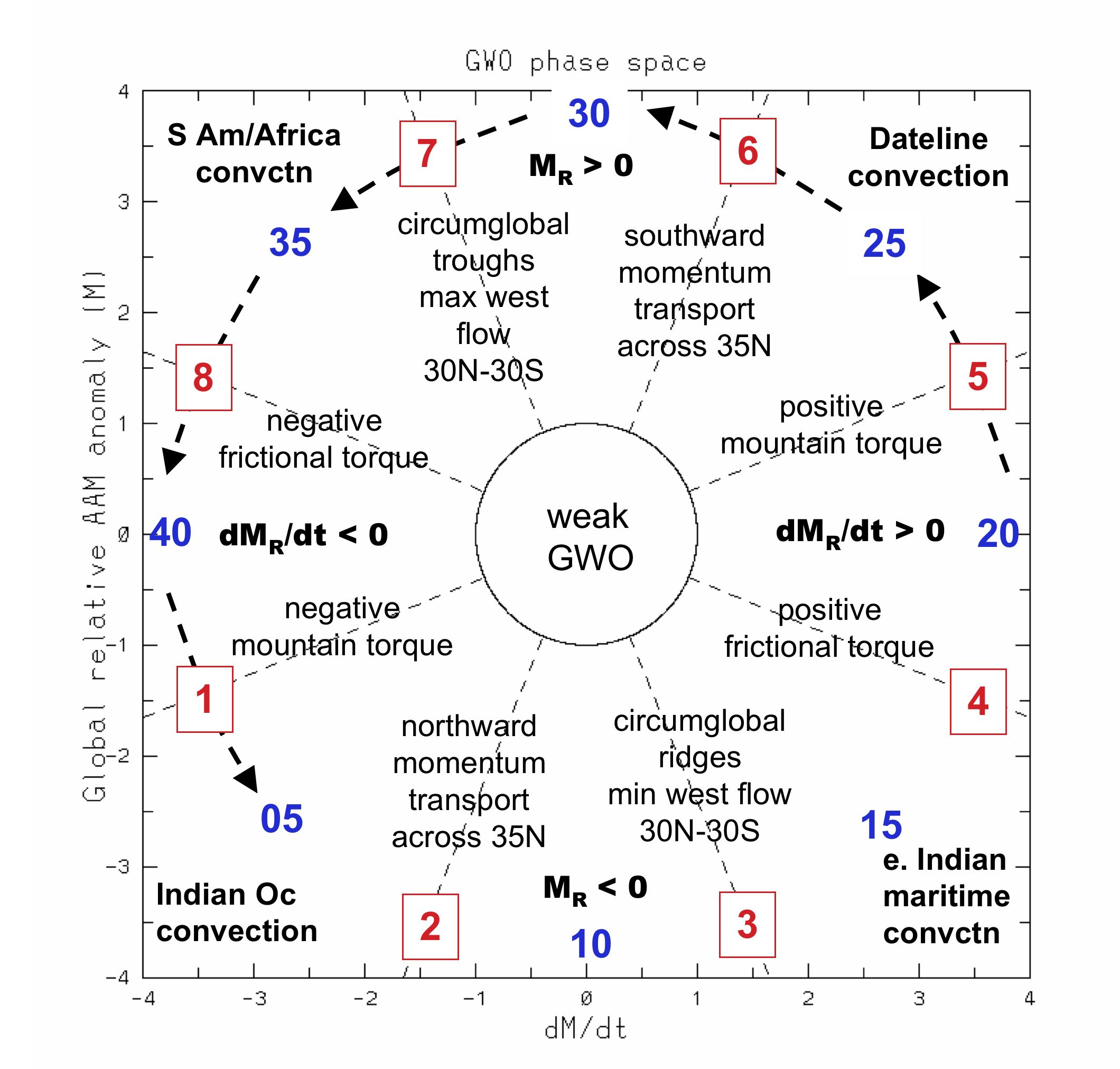
The GFS/Euro both have the MJO strongly and definitively progressing through phase 6 and towards phase 7 into late November. This could be indicative of a similar angular momentum/global wind oscillation orbit to what we are currently seeing, as per this CFS forecast:
An orbit through phases 5-7 (as has recently occurred) supports convection moving east towards the Dateline and eventually the western hemisphere, along with positive mountain torque and troughiness into the mid-latitudes:
With that said, we are fighting the background state and there is some uncertainty to how all of this progresses 10-20+ days out. Getting the tropical forcing to propagate east again (as the GFS/Euro ensembles are suggesting towards late November) and getting another push of increased east Asian mountain torque is likely critical towards the door being open for a very block and cold December with elevated snow potential across a good portion of the CONUS. If not, the chances for a mild start to the winter quickly increase.
-
9
-
11
-
The burst here in the middle of the night managed to drop a tenth of an inch or two on colder surfaces, which was all gone by 8 AM when I next looked outside. But, on the board.
-
2
-
.png.f04d7e0f39dbfb13a029e5b5c66df65a.png)
.gif.d74a475201f887b451ab7ed1ec1e9fe9.gif)


.gif.2ecc34a5bdba2895d5cd3c6838039651.gif)
.gif.50593ef89d8427cc605ec3bdbba97f08.gif)

Some Thoughts On The Next Couple Months
in Weather Forecasting and Discussion
Posted
Definitely a good call on the late November warm up...suspected we'd get a milder spell, but for a week or so the CONUS will be very mild. Looking into December, I still remain quite intrigued...agree with Matt that I feel like we may be getting somewhere with the pattern pretty soon.
the ensembles are increasingly keying on a pattern featuring a -EPO and -NAO into the first half of December, though with an initially -PNA. This would support colder air pressing back into the CONUS starting early next week out west after a relatively brief hiatus (on the broader, national scale). With an initially -PNA the cold air will first focus out west with mild weather over the eastern U.S., though a persistent -EPO and eventual -NAO could change that. Ok, time for some loops:
So to start, the pattern early in the loop is a mild one across the CONUS. There’s troughing over Alaska (a positive East Pacific Oscillation/EPO) that’s flooding much of the CONUS with milder air after our impressive mid-November chill. With a -PNA (Aleutian ridge/west coast trough) any limited cooler air is going into the western U.S. right now.
But, focus on Scandinavia (northwestern Europe). A persistent Scandinavian block has been ongoing and is progged to amplify this week. First, it sends a blast of cold air into Siberia and the rest of eastern Asia, a key to changing the Pacific pattern. Then, the block is shown on the European ensemble mean to retrograde towards Greenland, causing a negative NAO to develop through early December.
This Scandinavian ridge/block has been persistently modeled for a couple of weeks, which is impressive…and it’s also a pretty important piece to the puzzle. The set-up, as everything is currently modeled, seems to support both a -EPO and -NAO developing through the first half of December.
The blast of cold air into eastern Asia sends strong high pressure down the eastern side of the Himalayas, in contrast to the current low pressure over eastern Asia. Low pressure lowers the resistance against the planet’s rotation east of these tall mountains, allowing the planet’s rotation to speed up ever so slightly. To conserve angular momentum, the Asian-Pacific jet slows down and retracts. This favors anomalous ridging over the northwestern Pacific and low pressure over western North America…not a cold pattern for the Lower 48.
Fast forward to later this week and beyond, when high pressure drops in east of the Himalayas and does the opposite, speeding up and extending the Asian-Pacific jet. This favors lower pressure over the northwest Pacific in the exit region of the jet and pushes the ridge east, while the added momentum into the Pacific jet amplifies that Rossby wave train. Low pressure over western North America is replaced by high pressure descending out of the high latitudes. It’s a much colder pattern for most of the CONUS, though the East Coast will be the last place to consistently get the cold.
Also note how Rocky mountain torque is demonstrably important. Early in the loop, high pressure east of the Rockies is in place, which favors intensifying/extending the jet over eastern North America and into the northern Atlantic. This favors low pressure over the North Atlantic in the left exit region and a +NAO. However, a series of low pressure systems developing east of the Rockies in the middle portion of the loop does the opposite, retracting the jet and giving the Scandinavian block room to retrograde.
To best illustrate, here's the 250mb wind loop:
Early in the loop, the jet streak is breaking near the coast of East Asia and the north Pacific ridge is well to the west. As the jet extends in response to the East Asian Mountain Torque, that ridge is pushed east, a pattern much more conducive for pressing cold air into Canada and towards the continental U.S…also check out the Atlantic. Initially, the jet is roaring off the East Coast, but as low pressures develop east of the Rocky mountains and cause a negative mountain torque, the jet pulls back and allows ridging to retrograde over the North Atlantic. This causes the NAO to trend negatively, and is more conducive to troughing over the eastern U.S.
Another way to visualize this chain reaction…cold dumps into eastern Asia. Alaska then goes from cold to mild. Cold air then begins pressing into the CONUS. As ridging retrogrades over the North Atlantic and cold continues to funnel into the west, increasing pressure is put on the Southeast ridge and the eastern U.S. gradually sees cooldowns. Probably a very up and down pattern in the east, and leaning much colder west. In general, as the highest latitudes warm, the mid latitudes cool.
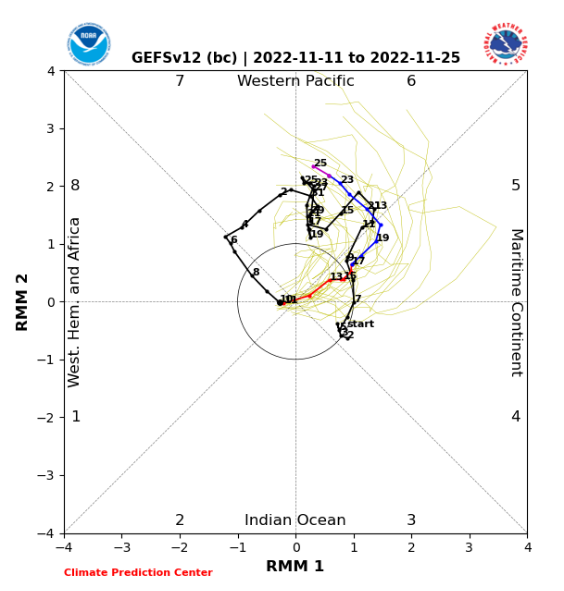
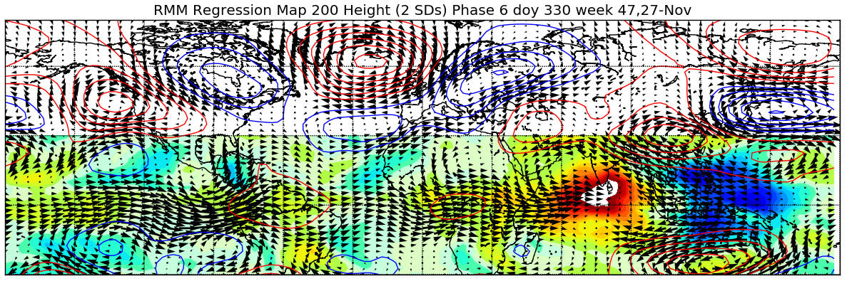
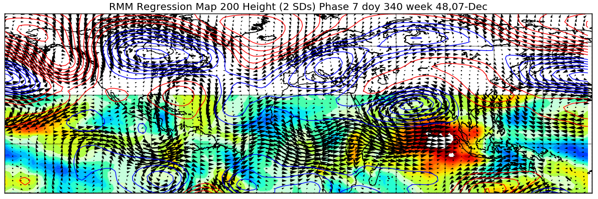
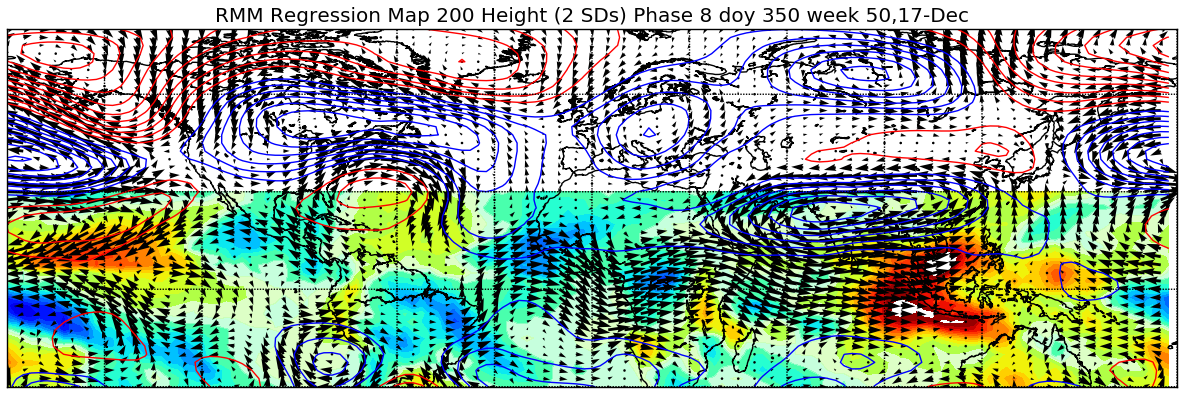
The MJO is moving into Phase 7 at a high latitude for the second time this month, and it could end up squeaking into 8:
Convection has been favoring the eastern Indian Ocean/western Pacific all summer and fall, a classic more “eastern based” La Nina response:
In the late fall/early winter, a phase 7 MJO is typically followed by ridging near Alaska and Greenland, a -EPO and -NAO respectively, with cold first dropping into the west and then spilling east. We are approaching Lag=0 now and will be Lag=1 and 2 next week into the following week (each lag is 5 days):
Lots of stuff pointing to a -EPO and -NAO and resulting colder pattern over the CONUS and slightly thereafter Europe as well…though don’t overlook the initial -PNA and Southeast Ridge causing cold to go into the western U.S. first.
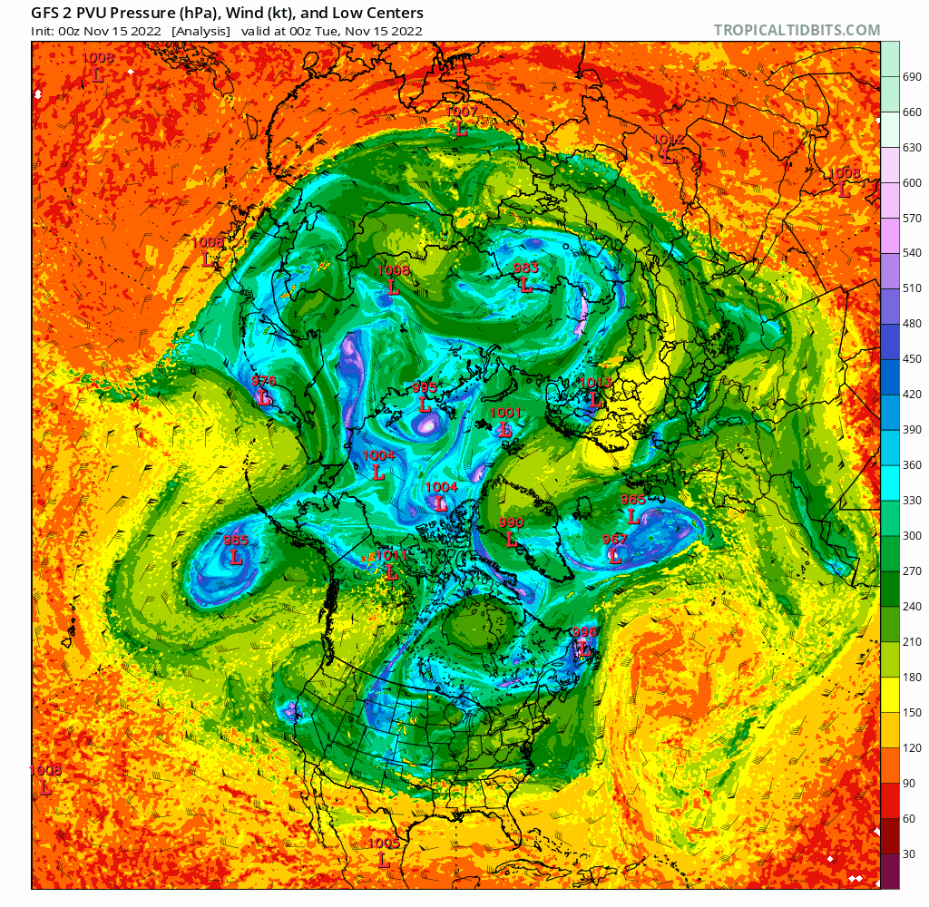
Can this return to cold through early December bust? As always with a longer range forecast, yes. My main concern is where the tropospheric polar vortex ends up, and if it splits as quickly as modeled over the next 7-10 days:
In particular, my concern is where the lobe over northeast Asia ends up. If it ends up dropping a bit farther east, it could mute any ridging into Alaska. I feel that’s on the less likely side, but it’s slightly precarious. If we see the tropospheric polar vortex split like the ensembles currently show, with one lobe into Siberia and another into northern Canada it bodes towards the colder outcome being favored over North America in December.