

OHweather
-
Posts
4,887 -
Joined
-
Last visited
Content Type
Profiles
Blogs
Forums
American Weather
Media Demo
Store
Gallery
Posts posted by OHweather
-
-
I’ve been up in the Mayfield/Highland Hts area this afternoon and there have been some decent bursts of fluffy lake effect.
The scraps overnight at my house brought my storm total up to 12.5”. Much of the area caught up yesterday afternoon through early this morning (although ironically, outside of Erie and Huron which didn’t verify, the warnings I’m least confident in being able to verify are Lake, Geauga, and Ashtabula lakeshore. The Ashtabula lakeshore zone is often hard to verify, but not verifying Geauga in this sort of setup while verifying the entire Cleveland metro would be quite a twist)
-
 2
2
-
-
17 minutes ago, LakeEffectOH said:
OHweather,
A little break from the current snow event...
")
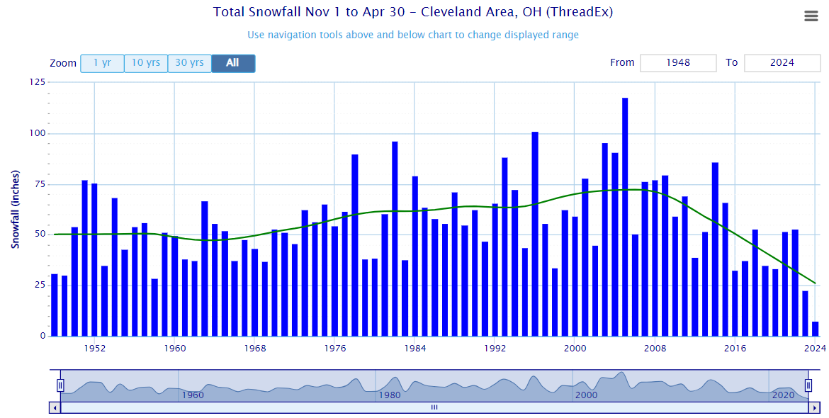
What are your thoughts about the recent crash in snowfall totals measured at CLE?

Link: https://xmacis.rcc-acis.org
Here are some of my thoughts on possible contributing factors:
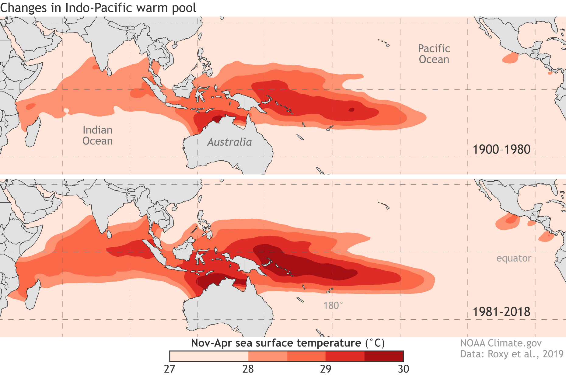
Recent tendency of the MJO to linger in the "Bad phases" (4-7); The changes in the Indo-Pacific warm pool could be a factor in this.
Expansion and warming of the Indo-Pacific Ocean:

A strongly negative PDO over the past several years:
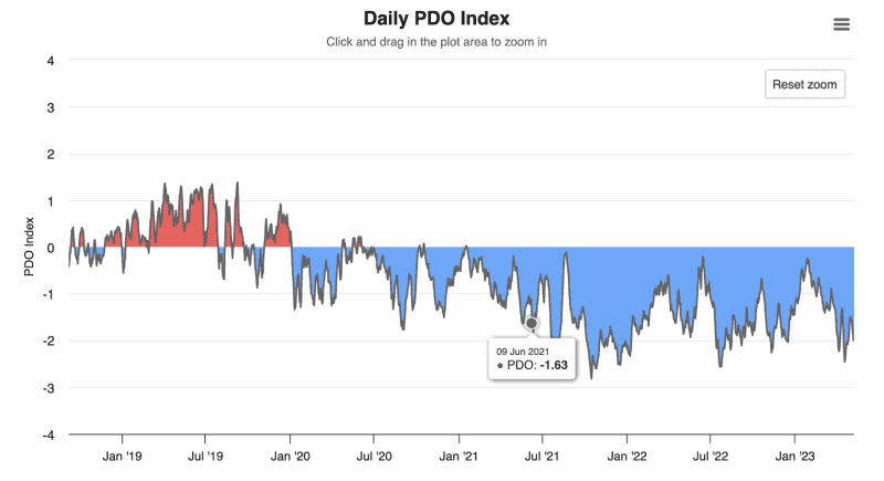
Link: https://www.worldclimateservice.com/2021/09/01/pacific-decadal-oscillation
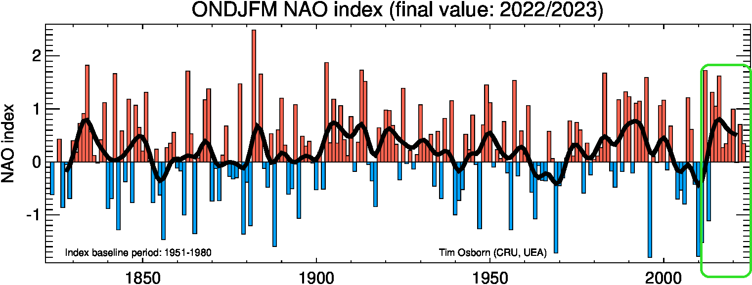
A greater tendency of the winter NAO to be positive, especially in the past 10 years, (circled in green):
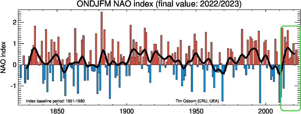
Link: https://crudata.uea.ac.uk/cru/data/nao/img/idl_nao_base1951-1980_ONDJFM_300dpi.png
Of course, there are many other factors, large and small, that are affecting our snow totals. I only hope this isn't permanent because of climate change.
I would be interested in hearing your and anyone else's thoughts.
I will take a better look and respond to this over the next couple of days! I have some thoughts but would like to look a bit more/think a bit more on it. CLE hasn't had a snowier than average winter since 2013-14 (though most other sites have had at least 1-2 since), so whatever the cause it hasn't been a trivial stretch of poor winters from a snow perspective.
-
 1
1
-
-
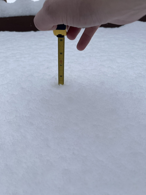
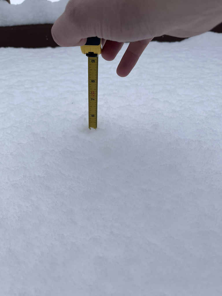
I'll do a measure and clear in an hour or so, but just sticking a ruler into my new snow since 1:20 brings my storm total to right at a foot! What an afternoon. Snow has finally slowed down, but hasn't stopped.
Also, woof:
https://x.com/Shinutsurai1/status/1748454511679582364?s=20
(17" public report from Maple Heights)
-
7 minutes ago, vpbob21 said:
Yeah the models always seem to overpredict lake enhancement this far west. It always seems to develop over Lorain/Medina then moves east from there. Not holding out high hopes for that band coming out of SE Michigan but we'll see.
I always love reading your posts on the long range outlook. Any chance you'll have a new one up soon? The 12z GFS looks about as brutal as it gets. I know I shouldn't put much stock in the 384 hr. GFS but given the state of the MJO and the AO/NAO it certainly looks believable.
I was going to try to put something together over the next few days or week. Have fallen slightly out of touch with the long range on night shifts and with the incoming snow the last several days. A warm up after this cold snap isn't surprising to me, but I'll admit the long range ensembles are not giving me optimism regarding how quickly cold may come back after the warmup.
I remember one event on super bowl Sunday in 2022 with this type of flow when a mesolow formed just east of the Islands and brought several (unforecasted) inches of snow to Erie/Huron Counties. This event gave me some flashbacks to that, but it didn't materialize at all. In that event the lake was mostly frozen but water opened up east of the Islands, whereas this one maybe it's the other way around with more ice there and more open water farther east.
-
15 minutes ago, NEOH said:
Definitely. Just looked at the models and it looks like they take the current band back southwest as it dissipates. Out this way we will likely have to rely on whatever forms on the NW flow. Sun is poking through now occasionally. Oof.
You may end up grinding out accumulations through tomorrow evening so hopefully you catch up some, but agree the band is wiggling back west at the moment. Where it pivots this afternoon totals will be huge. I have 5.2" new since my 1.4" morning measure and it's dumping again here. The band will probably wiggle west until 3 or 4pm and then snap east after that as the trough axis moves through.
-
3
-
-
27 minutes ago, vpbob21 said:
Looks like just under 2" here. Should be the final total. Surprised CLE hasn't killed the WSW for Erie/Huron yet.
When the better lake enhancement started developing in Lorain Co early this morning the writing was unfortunately on the wall for the Erie and Huron warnings. The synoptic snow being even more boring than hoped hurt even more. With all of that said, there’s an interesting area of enhancement along a trough axis (with some Lake Huron connection) swinging southeast out of MI right now, so you may be able to add some more when it swings through later this afternoon. Not enough to get you close to 6” but maybe another inch or two wherever it goes.
 6 minutes ago, NEOH said:
Still a persistent light snow here in south russell... very small flakes. Looking forward to having that band move east later today.
This event has been painful outside of the lake enhanced band.
-
15 minutes ago, Stebo said:
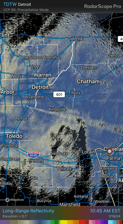
Still getting some solid moderate snow here at DTW with the lake effect/enhancement off of Huron. Definitely an event saver for sure.
Same here with the lake stuff vs the synoptic. The synoptic at least produced a widespread accumulation but was largely hot garbage. QPF trended down the last couple of model runs and the ratios were more pedestrian. The lake enhanced stuff is high ratio and fairly intense.
-
This lake enhanced band is quality...night and day compared to the widespread synoptic stuff. Just stuck the ruler in (didn't do a formal measure and clear) and have about 2.5" new since 8:30 (storm total nearing 4") and it is dumping dendrites under the band at the moment. Hopefully it persists through the late afternoon and swings around enough to give everyone a nice boost.
Edit: 7" LSR from near Lakewood where the lake enhancement was more persistent this morning.
-
13 minutes ago, Floydbuster said:
Thank you for the response. The "app" I showed is typing "Cleveland Weather Hour by Hour" into google. The other apps are the "weather" apps that people have on their I-Phones.
Of course, I use the official NWS website and read the advisories, but of course I'm far more seasoned in tropical weather and hurricanes despite living in the snowy midwest.
The Google search is concerning because I could see a lot of people doing something like that. A lot of the default phone apps use AccuWx or TWC as their "data" (I'm sure there are some others though)...which is better than Google at least, but still iffy.
Snow has picked up somewhat in Macedonia where I am...probably close to an inch new since I measured. Hopefully we're looking at a nice, snowy next several hours around here to make up for the lack-luster synoptic snow.
-
8 hours ago, Floydbuster said:
That's what I'm saying as well. Everyone is acting as if the entire area is in for a wild ride, and I actually don't think it'll be that bad. Last Friday, before the switchover to rain and gusty winds, we had a good 2 inches fall in about an hour and a half. Compare that to perhaps 4 inches in 2-3 days time? That's nothing to me. I certainly think they could have higher accumulations near the lakeshore, but further south, probably not nearly as much.
Also, everyone has been very confused because we have local weather apps on phones showing no more than 30% chance of precipitation here and there the next two days, yet we have a Winter Storm Warning issued warning people to prepare for "5 to 10 inches" of snow. Lots of conflicting forecasts.
Look here...Cleveland weather Friday and Saturday....

Friday shows no more than a 50% chance of precipitation around 8am this morning for Cleveland, tapering off.

Then on Saturday, it tapers off further to 0%.
How the hell does Cleveland get 5-10 inches of snow Friday and Saturday from near zero precipitation chances? Anyone wanna help me out on this one?
I agree with many of your points here...yes, that short burst of heavy snow last Friday heading into the evening rush was impactful and I would agree that peak rates (if they last any amount of time) are more important to the impact than the final storm total at the end of it.
As for the weather app only showing 50/50 precip chances...I don't know what to tell you. I don't know who the provider is or how they come up with their forecasts. Seeing as though it's currently snowing everywhere it is garbage. I can see how 5-10" of snow on 50/50 chances for snow is confusing but the app appears to be bad.
I usually advise people to pick a couple sources for weather information and stick to them..."shopping around" just gets confusing. I would suggest checking the NWS webpage (weather.gov/cle/winter) and social media (if you're on it) as those forecasts are what drive the watches/warnings/advisories...and we're certainly not perfect, but you're not going to get something there that's completely out of left field. You'll also be able to see the gridded snowfall forecast for the whole area, so you don't have to guess. There's collaboration that occurs shift to shift, between offices, and with the Weather Prediction Center (WPC) on things like QPF and snow so it's hard for a forecast that's entirely unreasonable to come out.
And to be honest, I don't think our TV mets are bad in general, especially if you find a channel or met you like. I didn't catch all of them yesterday but I didn't see anyone hyping any crazy snow amounts, especially in Summit. I think people tend to run with the worst number they hear...and I do think it's a struggle to message storms like this where it won't be a heavy snow amount outside of the lake enhancement...and where the snow won't all fall at once. We never had 10" amounts listed in Summit County's warning, although if you told me that the warning probably doesn't apply to the southern half of the county I'd agree.
We do attempt to keep these messaging/perception things in mind. This was posted to the NWS social media yesterday morning and emailed out to "core partners":
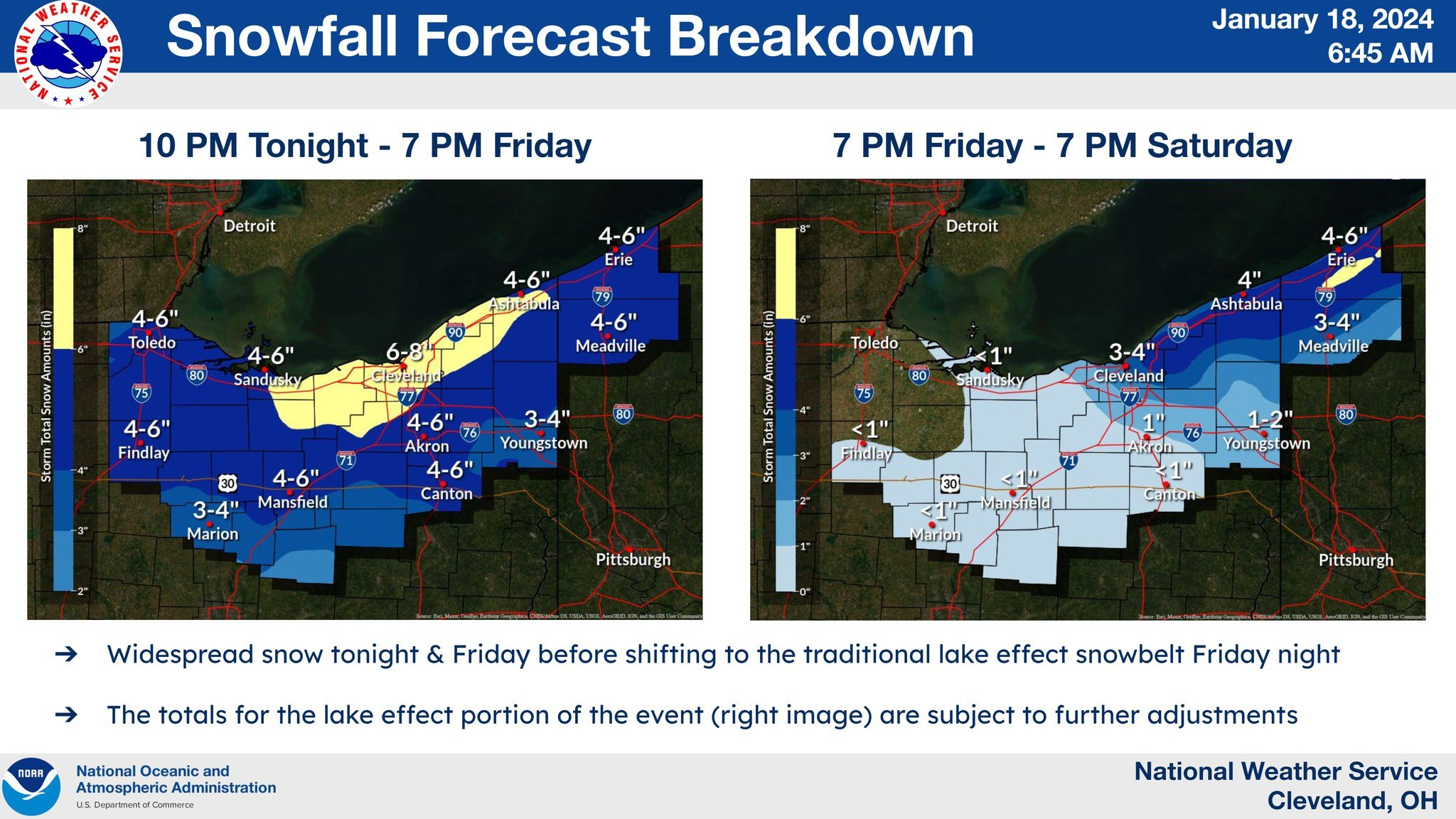
It's not going to be perfect. The synoptic snow has trended down a good 1-2" farther south and west (and I hate that amounts in NW OH of 4-4.5" trigger the 4-6" range for the cities because they're realistically going to get 2-3"). But it also gets across that most areas are not getting 6"+ of snow in any 24 hour period, which was why we broke it down like that and sent it out. The areas that were forecast to get 6"+ in either window were where I did warnings yesterday morning (we no longer have a time constraint for warning criteria...just needs to be 6" for an event...but still wanted to draw a line somewhere). The big error here was the synoptic snow trending down 1-2", and the Erie/Huron warnings are probably not going to pan out. They have had some lake enhancement this morning but the best enhancement has already set up to the east and amounts so far out there appear to be 1-3".
As for us farther east, the best lake enhancement is definitely working east now and guidance suggests it will pivot for a good few hours through mid-afternoon over parts of Lorain, Medina, and perhaps northern/western Summit before pushing farther east and transitioning to more traditional lake effect tonight. We still have a chance to pick up a decent amount of snow in parts of Summit through this afternoon.
-
1.4" new here so far. The synoptic snow was never going to be that exciting but it's going to end up being a general 1-3 instead of 2-5 across northern OH. Hopkins reported 1" of new snow last hour so the enhancement is working out...just need it to swing east, which is expected.
-
2
-
-
16 minutes ago, Floydbuster said:
People are hyping this one up big time. Nearly every school in Northeast Ohio is closed for Friday. Color me skeptical. I think this snowfall is being vastly overestimated.
But is 4-6" of snow falling in a 36 hour period in Stow, which is what the forecast is, actually hyping it up big time? Can't control that all the schools are closing but the forecast is not for anything your area hasn't seen before. It'll be decent farther north where there's more lake enhancement.
.thumb.jpg.806f426f4131c8a190b571d556c090e6.jpg)
-
12 hours ago, Frog Town said:
Thank you! Toledo area superintendents appreciate your insight.
I see it barely flaked before about 8am but is snowing half decently now. Hopefully, most or all stayed open today but close tomorrow (which is probably the correct answer in this situation)
46 minutes ago, NEOH said:Nice to wake up and see this in the forecast, and great to have OHWeather forecasting this event for CLE.
Hopefully the typical "OHweather reduction" doesn't come into play since we did all the headlines this morning

That was my last shift of the stretch so I get to just watch it play out and enjoy the snow. Have a feeling that the abundant synoptic moisture and good ratios will lead to this performing well, hence the somewhat aggressive forecast, but always get slightly nervous when model QPF is somewhat modest and we need ratios to get the totals to pan out. It can work though. The lake effect will linger all the way through Saturday in the primary snowbelt...likely won't be heavy by then outside of the Lake Huron band (which will be farther east) but it will snow for a long time.
-
1
-
1
-
-
On 1/13/2024 at 7:07 PM, Floydbuster said:
Welp, that was interesting.
Here in NE Ohio, everyone I know lost power bad during the straight-line wind thunderstorm that blew through in late August of last year. The forecasts showed winds gusting 50-60 mph, and we have been on edge since Thursday. Every single person I talk to says they're "done with snow and winter", and I personally detest winter weather, so we were happy that we had no snow accumulation. I should note, we had a quick 1-2 inches in an hour around 4pm Friday night before turning to rain and melting away.
Thankfully, it's past us, so now we just get some arctic air. Overall, the local mets hype about winds didn't get *quite* as bad as we had been fearing.
For those more seasoned in winter weather than myself, was the storm weaker than expected? Did the winds underperform in NE Ohio or was it what you guys expected?
On Friday the general consensus was that the low would bottom out around 975mb Saturday morning. It ended up getting to about 980mb. So it was a bit weaker than expected, and the gradient winds on the backside were slightly weaker as a result..the High Wind Warning verified in spots, but the southern row or so of counties in the warning fell a few mph short.
-
1 hour ago, Frog Town said:
Any insight in the Toledo area tonight. Need to make decisions regarding school closings and it looks like we could have a couple inches in Toledo by 8am. Thoughts?
The setup tonight into tomorrow is odd...narrow band of snow, the lift isn't that strong, but it looks like it'll be a very fluffy / high-ratio snow so it'll stack easily...plus it will be falling onto cold roads. I'm not that impressed through about 7am, seems like any accumulations by than are on the order of half an inch to an inch in Toledo. Lift does get a bit stronger starting right around 7-8am, so I could see spots getting another couple inches the rest of the morning. It should become much lighter during the afternoon. I realistically think the Toledo area gets 1-3" but with the heaviest occurring between like 8am and Noon. Someone could get a fluffy 4" but most will be less and feel like 3-4" amounts would be more likely into MI. There will be a sharp southern cut-off, so there's some chance it stays a bit farther north, though a total whiff seems pretty unlikely. I I think Friday morning is a little more clear cut, it'll snow 2-4 or 3-5" everywhere out there with peak rates between 3-9am (give or take).
-
2
-
-
49 minutes ago, LakeEffectOH said:
Well, we're under a Winter Storm Watch...
URGENT - WINTER WEATHER MESSAGE
National Weather Service Cleveland OH
230 PM EST Wed Jan 17 2024

OHZ009>013-019>021-180330-
/O.NEW.KCLE.WS.A.0001.240119T0600Z-240120T0600Z/
Erie-Lorain-Cuyahoga-Lake-Geauga-Huron-Medina-Summit-
Including the cities of Sandusky, Huron, Lorain, Elyria,
North Ridgeville, Avon Lake, Cleveland, Mentor, Willoughby,
Eastlake, Painesville, Willowick, Wickliffe, Chardon,
South Russell, Bainbridge, Chesterland, Middlefield, Burton,
Norwalk, Willard, Brunswick, Medina, Wadsworth, and Akron
230 PM EST Wed Jan 17 2024

...WINTER STORM WATCH IN EFFECT FROM LATE THURSDAY NIGHT THROUGH
LATE FRIDAY NIGHT...

* WHAT...Heavy snow possible. Total snow accumulations of 4 to 8
  inches possible.
* WHERE...Portions of north central and northeast Ohio.
* WHEN...From late Thursday night through late Friday night.
* IMPACTS...Travel could be very difficult. The hazardous
  conditions could impact the morning and evening commute.
Interesting that Ashtabula county was left out. Me thinks that Ashtabula has different criteria for winter storm messages.
Same criteria for warnings and advisories across the whole CWA (though if push came to shove we may be slightly more inclined to issue products for marginal amounts outside of the primary snowbelt). We have a bit less snow in the forecast in Ashtabula and NW PA than where the watch is, though I suspect we may eventually need warnings out that way because it will keep snowing through Saturday downwind of Lake Huron. I am excited for the snow and excited for the forecast shift tonight!
-
1
-
-
Interesting little warm air advection/frongogenesis driven snow potential on the front end of things tonight into Thursday...I expect the "clipper" (more hybrid) and lake effect Thursday night into Friday to perform quite well. Soundings suggest a deep DGZ and good snow growth with the clipper. Instability will be deep over the lakes beneath the lobe of the PV.
.gif.aec1a52979139838bc1f7c3cf423b00f.gif)
The primary shortwave responsible for this system...can call it a clipper I guess, it does move over southern Alberta...has Pacific origins. It is modeled to interact positively with both a small lead wave in the subtropical jet over the Ohio Valley Thursday night but also the incoming lobe of the PV. Models have converged on this idea of a positive interaction between these features occurring Thursday night into Friday morning as the "clipper" takes on a negative tilt. The addition of moisture from the sub-tropical piece (and a bit of moisture from the Pacific), along with the increase baroclinicity provided as the polar vortex and Arctic air come in, allows for potential for a large swath of moderate, high-ratio snow accumulations. This has more upside than a standard clipper.
.gif.41687008aad0962ba1724a0a3fcfa7ea.gif)
Note in the 500mb loop that the PV lobe swings through the southern Great Lakes through Saturday, bringing in deep cold air and allowing for strong instability to develop over the lakes. This instability, combined with lingering synoptic moisture and lift as a pronounced inverted trough axis hangs back into the Great Lakes in the low-mid levels, will support robust lake effect snow well into Saturday.
.gif.800ed9348f516c7d3a12427c70d1f8b1.gif)
This should be a fun sequence that produces fluffy snow in a large area and is ripe for mesoscale surprises, especially near the lakes.
-
8
-
1
-
-
1 hour ago, NEOH said:
Ha. Just read the AFD you wrote... hopefully this event works out.
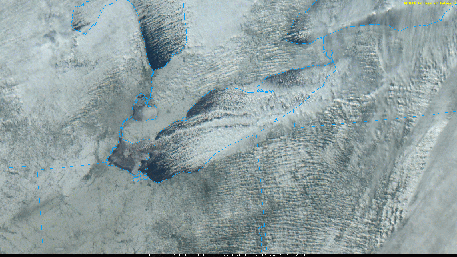
Confidence is increasing in at least a light snow area-wide late Thursday night into Friday following by lake effect snow later
Friday into the weekend. There is some potential for a more notable synoptic snow if the more amplified solution with Friday`s system
proves correct, though that widespread snowier outcome is still on the "less likely" side. Regardless, the set-up looks favorable for
notable lake enhanced/effect snow Friday into Friday night from the Cleveland metro area into both the primary and secondary snowbelt
with a north-northwest flow. While growing ice in the western and perhaps central basins may be a small negative, there should still
be enough open water for a robust lake response. Ice needs to be thick and locked in to really limit that.
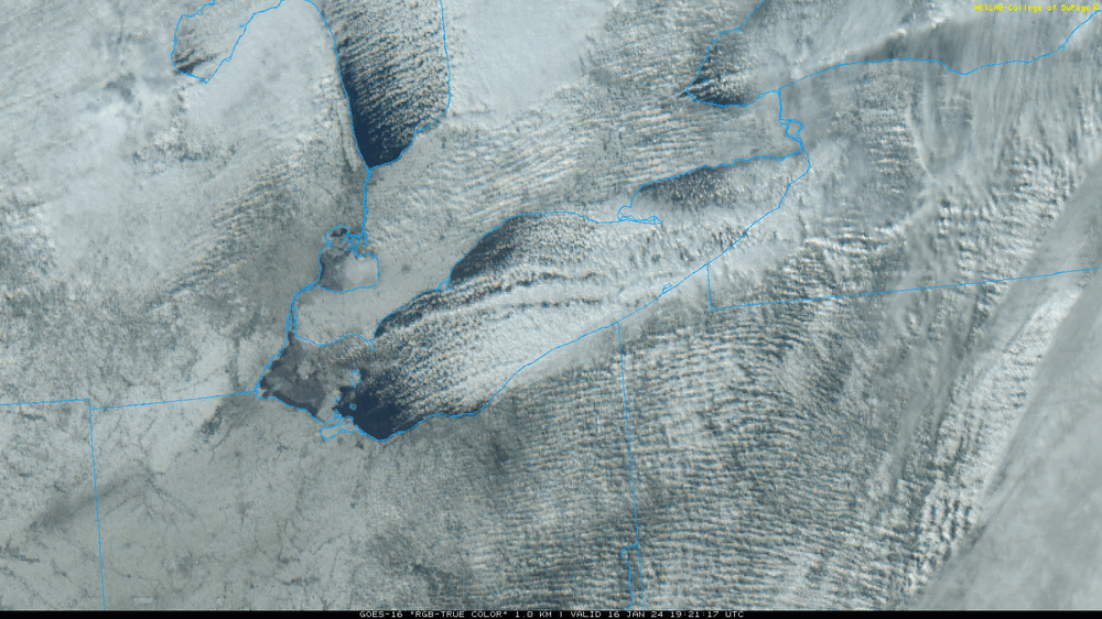
The satellite loop from this afternoon is encouraging...not really much in the central basin and the ice out west has moved some, and you can tell there's some flux through it still. We'll see how much more can grow the next couple of days...tonight will be quite cold so I'm sure it will grow, but we get more strong SW winds over the lake tomorrow. Winds get much lighter Thursday-Thursday night but air temps over the water won't be as cold then as they will be tonight. I'm sure there will be net ice growth between now and Friday, but east of the islands should still be open enough for a decent heat/moisture flux.
-
1
-
-
In spite of the ice, I’m probably more optimistic about the next 4 days regarding snow locally than I’ve been about any 4 day stretch so far this winter. Which isn’t saying too much

-
4
-
-
5 hours ago, Frog Town said:
Of course my friend. I have a ton of respect for you guys in a very unforgiving and difficult craft. I was probably too excited to notice the time stamp.
Haha it’s all good, I used to be the one making posts criticizing our local office and I think part of it is just not being aware, from the outside, what the thought process was…since it was my forecast shift I don’t mind explaining what my reasoning and thought process was. This was a tricky scenario/low confidence forecast given the mild temperatures, and in hindsight I wished I went with my gut feeling when the snow first started as impressively as it did.
-
On 1/12/2024 at 3:31 PM, Frog Town said:
WWA posted for Toledo. A little late to the party
On 1/12/2024 at 3:21 PM, nwohweather said:NWS Cleveland needs to get WWA's up ASAP. The snow is far more entrenched along the lines of what the GFS showed than what they predicted. Tough call, but I think 3-4" is capable. It's definitely extremely wet, heavy snow
To be fair, I hit send on this a little earlier than these posts:
URGENT - WINTER WEATHER MESSAGE
National Weather Service Cleveland OH
248 PM EST Fri Jan 12 2024

OHZ003-130000-
/O.NEW.KCLE.WW.Y.0002.240112T1948Z-240113T0000Z/
Lucas-
Including the city of Toledo
248 PM EST Fri Jan 12 2024

...WINTER WEATHER ADVISORY IN EFFECT UNTIL 7 PM EST THIS
EVENING...

* WHAT...Wet snow occurring. Additional snow accumulations of up
  to two inches.

* WHERE...Lucas county.

* WHEN...Until 7 PM EST this evening.

* IMPACTS...Plan on slippery road conditions.

* ADDITIONAL DETAILS...Heavy wet snow will impact travel
  conditions through the evening commute.
We were aware of the potential for an impactful burst of wet snow in the Toledo area, but yes the advisory came out later than would've been preferable. I had a bit of a gut feeling around 1 PM when TOL immediately dropped to 3/4 mile visibility in snow when precip came in...but since it was still 36-38 degrees across Lucas County, raining in Wood County south of the turnpike, and only sticking to grass in western Lucas County (not in the city of Toledo) I wasn't sure if it'd snow long enough to accumulate 2"+. I have no problem issuing an advisory for less than 4" of snow (our technical advisory criteria) based on impact, but there has to be a line somewhere and I don't want to do an advisory if I'm not confident it'll snow at least a couple inches. We issued a Special Wx Statement for up to 2" of quick snow accumulation and slick road conditions around 1:20. By 2:30 Findlay flipped to snow, precip rates were intensifying, and snow was sticking to roads in Lucas County. It was obvious that conditions would be poor through the evening commute and also that snow accumulations would be a good couple/few inches in western Lucas County, so we went with the advisory at that point.
-
1
-
-
12 minutes ago, michaelmantis said:
So how do the updated grids (which has me at 5-10 for the next 24 hours based on the update Borchardt seems to have done a few minutes ago) match up with this posting from 8:51 PM that shows 8-12 (based on the Probabilistic Forecasts)?
Not knocking anyone, just wondering how different numbers can come from a NWS office within an hour of each other and it looks like Borchardt published the 8:51 PM update too?I'm seeing snow maps on that page from 3:36 PM still. I looked at the NDFD (NWS forecast grids) on WxBell, the snow amounts went down about 1-2" from the 3:36 PM forecast.
The rest of my post isn't addressed at anyone in particular so not lecturing, just explaining. I'm not sure what LOT does, but in eastern region we have mandatory near term updates every 3 hours. I'm guessing they have similar at LOT. Evening shift is more than entitled to another look at the forecast based on observed trends, rapid update models, early arriving 0z models, etc...and yes even another set of eyes. Different mets are allowed to have slightly different interpretations. Evening shift involves a full set of TAF (airport forecast) updates which is extremely important for ORD and MDW. It's also the last look at the forecast before the morning commute, so if it's snowing during the morning commute it's the last chance to message it with leadtime. I don't see this as a drastic change by LOT this evening or as anything that's out of the ordinary to tweak a high-impact forecast for an ongoing winter storm. Given how mild this storm is, slightly lower numbers are always a risk. Still should be fun and exciting tomorrow.
-
1
-
1
-
-
The updated LOT snow grids are about 1-2" lower on average than the prior, with similar or slightly higher (by about 0.05") QPF. It's not a big change. Storms with a ton of QPF, a period of heavy rates and low ratios are horrible for the roads and are very impactful. With that said, temperatures across most of the LOT forecast area will be 31-33 degrees during most of the snow (warmer along the lake and mainly at or slightly above freezing (even inland) during peak heating). It will be hard to measure high totals. Someone certainly can where the band pivots...2"/hour adds up fast. But where those heavy rates aren't quite as persistent it'll be harder to stack it that fast. Doesn't reduce the impact. Getting 1-1.20" of QPF as wet snow followed by gusty winds is definitely enough of a combo for power-outage concerns, especially where it's near or slightly above freezing for a good portion of the snow.
-
2
-
-
Steady snow at night in January at 32-33 degrees can definitely coat roads. Ground is never all that warm in January. Although I slightly downplayed amounts in NE IL tonight, it'll be slick when it's snowing with this denser wet snow...and some of the obs in this thread from where it's snowing and down to 32-33 seem to suggest it can accum at a half decent rate where the heavier returns are.

.jpg.9569ae93621ddb8095f7146dccdedb80.jpg)
Northern Ohio Obs/Discussion Part 2
in Lakes/Ohio Valley
Posted
Went for a hike in the Novelty and Punderson areas this afternoon and drove 422 into Solon around 6 PM. Decent LES out there. Could definitely tell Novelty had gotten a few inches of very fluffy snow today and it was still coming down, especially when I left. The conditions coming into Solon when the LES band was more consolidated were solid, with visibility reduced to about half a mile as dendrites dumped. Snow rates may have been close to an inch an hour, the highway and main roads in Solon were snow packed with a good inch, and side roads and parking lots that were less disturbed looked to have a good couple inches on them.
Back in Macedonia, I picked up slightly over an inch today...giving me a total of 13.7" over the last two days. It hasn't snowed many times this winter but when it has, it has delivered here.