

OHweather
-
Posts
4,887 -
Joined
-
Last visited
Content Type
Profiles
Blogs
Forums
American Weather
Media Demo
Store
Gallery
Posts posted by OHweather
-
-
1 hour ago, RCNYILWX said:
I can confidently say that part of the problem with the ice storm forecast out there was the new ptype methodology we were forced into this winter. We had imo a much better system in place for several years up until last year.
Sent from my SM-G998U using Tapatalk
But here I was under the impression that if we just pulled in the WPC QPF and snow ratios and then ran Forecast Builder and pulled in the NBM temps and dews and clicked on a few buttons and ran the unconditional probability of weather type grids that I’d get a perfect snow and ice forecast in 5 minutes. In all seriousness, I think you folks in central region had a better ptype process than we did up through last winter in eastern region…I was training last winter and only touched mixed precip grids a few times, but it was impossible to get what we wanted with the old conditional wx type grids and top down method we were still using, and there were multiple different tools being used to get those grids by offices around us so it was hard to collab. A lot of hand waiving trying to manipulate grids. I feel like the methodology we use now IS somewhat easier to manipulate and get what you want, but I also feel like it’s rare that I don’t feel inclined to do some amount of editing to temp, dew point, and the various PoWT grids to get what I want in any sort of mixed/changing ptype scenario because the PoWT grids frankly aren’t meteorologically reasonable sometimes. Unfortunately, the level of willingness to make those grids edits seems to vary quite a bit from met to met and office to office, and I feel like those who are reluctant to make edits are prone to doing a less thorough analysis than they otherwise would (with a last second colder trend and unusually efficient accretion with decent rates and temps at or above freezing that recent ice storm was just difficult on the southern fringe, though poor starting grids from NBM/FB couldn’t have helped).
Before I derail this thread too much more…my impression on this storm is that every model suggests that when the storm reaches maturity and peak intensity that very strong lift in the DGZ in the deform band will yield sufficient rates and large flakes to overcome any BL thermal issues. I’m pretty confident someone gets smoked. However, the big difference is regarding how quickly the storm deepens and reaches peak maturity which heavily impacts where the deform band reaches peak intensity and is best able to overcome any marginal thermals…as one would expect, the slower deepening favors the E/SE solution.
I feel like the extremely sharp and rather anomalous subtropical shortwave, coupled jet structure, and high PWATs/low static stability argue for the quicker deepening, though it’s primarily a sub-tropical jet storm with little actual phasing with the polar jet, so both the track and shape of the precip shield on the northern/northwestern side will be quite sensitive to the amount of confluence to the north/northeast of the low. While I don’t think wholesale changes will occur at this range, subtle changes with that confluence could lead to track bumps to almost the last minute. My gut feeling is we don’t see a track any farther south than the GFS or CMC, but the NAM and Euro seemed to have inched a bit less amped so we’re probably narrowing the envelope.
-
 1
1
-
 6
6
-
-
2 minutes ago, sielicki said:
Clearly these offices are still learning to deal with their collective PTSD from how badly the Dec21 storm was called.
When you call for warnings a week early and the models leave you hanging at the last minute, normal people are pissed but the weather nerds understand where you were coming from.
When you call it during (borderline after) the event, weather nerds will make forum posts laughing at you, and normal people will think that you nailed it.Clearly, among the two options, they prefer to be the ridicule of the Ohio valley subforum. Such is life.
So, I can say with a fairly high degree of confidence that the December storm underperforming had 0 to do with advisories/warnings being conservative on the southern fringe of this one.
With that said, you are correct that the general public (and decision makers) does not like having their daily lives disrupted for what ends up being a busted forecast/not a major event and we do take that into consideration, meaning if we're issuing a warning product of some sort we want to be fairly sure, and usually won't do it in a "could go either way" situation. I can't comment on the meat and potatoes of the forecast farther west into IN/MI/IL, but in NE OH/NW PA there was a pretty notable colder trend at the last minute leading to more widespread freezing rain and greater amounts of it farther south than expected 24+ hours out. When you combine a last minute colder trend (that forecasts needed to adjust/catch up to) and the fact that good accretion occurred during the day with temperatures at or slightly above freezing (not unheard-of, but understandably tough to forecast) I can see why warnings ended up being very reactive on the southern fringe. If you want a lesson to take away from all of this as a forecaster, a legit cold high and advection of lower dew point air into a freezing rain situation can cause it to surprise on the fringes...a lack thereof can cause underperformance.
-
1
-
1
-
-
Ice accretion is fun...definitely an interesting one today with places getting over a quarter inch of accretion with air temps at or slightly above freezing for some or all of the freezing rain.
Basically, wet bulb temp, wind speed, and precip rate determine how efficiently freezing rain will accrete. Higher precip rates don't accrete as efficiently due to more of it running off before freezing...though on the flip side very light freezing rain or drizzle can accrete at a better than 1:1 ratio to the liquid amount. Otherwise, it's a battle against latent heat release. If air temps are slightly above freezing you can accrete (as many saw today) if the wet bulb temperature is below freezing due to evaporational cooling. However, when the rain freezes it gives off latent heat which warms the surrounding air, so wind is also very important to the equation. Stronger wind whisks away the latest heat given off and can continue advecting in drier air. Strong winds can also increase accretion efficiently due to giving each given rain drop a greater chance at encountering an elevated object (since the drops move more horizontally as they fall when wind is stronger).
Typically, it's a battle against the latent heat release and often that battle doesn't last very long if the winds are light and the dew points aren't that low, but in a set-up like this with an actual cold high to the north advecting in a drier airmass it all balanced out fairly well. I'm guessing the efficiency of the ice with temps at or slightly above freezing was not well forecast...we also under-did accretion here in NE Ohio to the point where we had a few power outages east of Cleveland, and much like farther west temperatures had to get firmly above freezing before accretion stopped.
-
2
-
6
-
-
23 minutes ago, NEOH said:
I was surprised by the amount of ice out this way. Everything is still glazed over. Hoping the mild weather continues at this point. Despite the ice today, it has looked and felt like Spring.
It definitely was pouring this morning, so that degree or two of colder temperature into Geauga County compared to Summit probably helped you accrete a good bit more. I figured we briefly had about 0.10" on the trees here, but there was enough liquid for more ice where it was a little colder. Unfortunately, it does look like we get some increased blocking in March...we'll see if that results in any snow or just blunts the warm pattern a bit.
-
Nice little glaze on the trees here. This feels worse than the winter of 2011-12 locally. I’ll be happy with any additional snow we get but at this point am enjoying the relatively mild temperatures that are locked in…it’s the hand we were dealt this season.
-
I managed to complain my way to 3.7” of wrap around/LES from pre-dawn Thursday through this morning. A little over an inch new overnight last night.
-
1
-
-
On 1/25/2023 at 8:14 PM, Chinook said:
I got 4.0 to 4.5" with pretty high density snow, with less than 4.0" snow depth on pavement, for sure. I think Toledo Express Airport has gotten 0.55" of water equivalent, so that could have normally been 5.5" to 6.0" on grass. It does look like 6.0" at Napoleon or Defiance with also over 6" towards Ann Arbor. I wonder what the COCORAHS spotters will see for their water equivalent of snow for the 2-day period. My area certainly could be 0.55" like Toledo Express Airport.
Seemed like all of the reports in Lucas Co were between 4-6” (but with no one reporting a full 6.0”). It was relatively impactful for Toledo as it snowed hard with a number of accidents involving semis on the interstates near the city in the early afternoon, but slightly less QPF due to the dry slot and low ratios ate into the expected snow totals a good bit. Just west where rates were more consistently heavy (and it was more like 32-33 degrees) got a goos 6-8”.
-
Just a POS, junk system here the last two days. Estimated slightly less than 2” of snow yesterday morning here, but wasn’t home for most of it and it was down to an inch of new slush by the time I got home. Watched it snow half decently and melt on contact all day at the office in Brooklyn Heights…in hindsight, my snow forecast for the LES in the CLE metro was too ambitious since it didn’t stick all day today and because winds backed SW quicker than initially modeled this evening. At home in NE Summit County it did accumulate better than closer to the city of Cleveland and it did come down for a time early this evening…a little over 2” new today.
-
2 hours ago, vpbob21 said:
Not sure if this underperformed because of lake influence or the heavier rates skipping around us. Probably a little bit of both.
Temperatures ran 1-3 degrees warmer than expected across almost all of our area and accumulations suffered quite a bit outside of the higher terrain and some areas closer to US 30 where heavy snow arrived earlier. A coworker near the office in Cuyahoga County had 1.6” of snow on 0.33” liquid which is

-
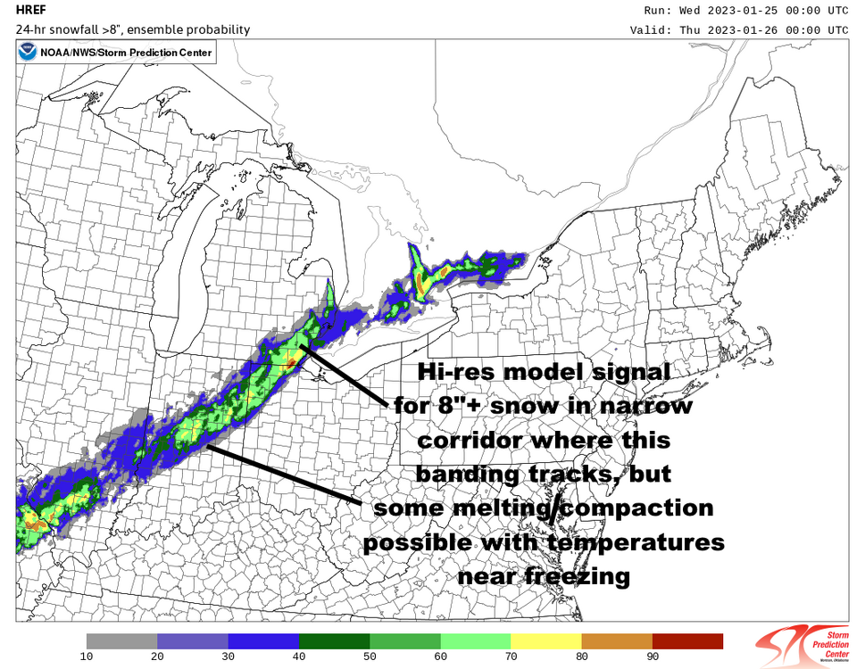
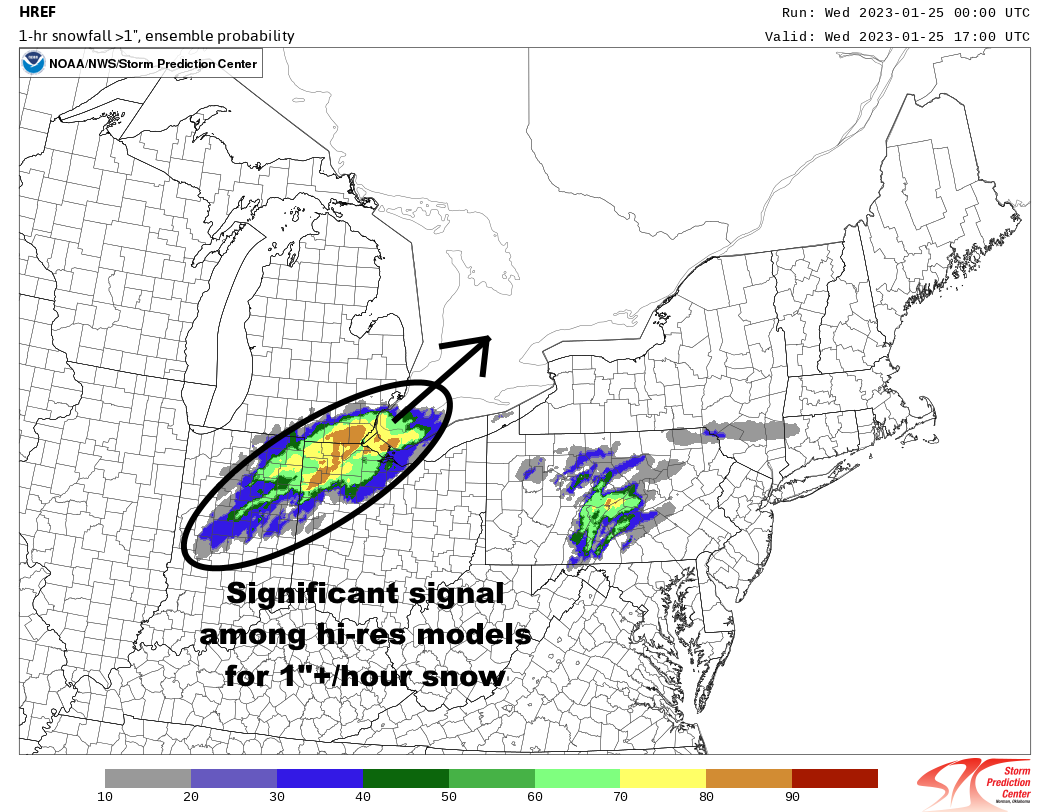
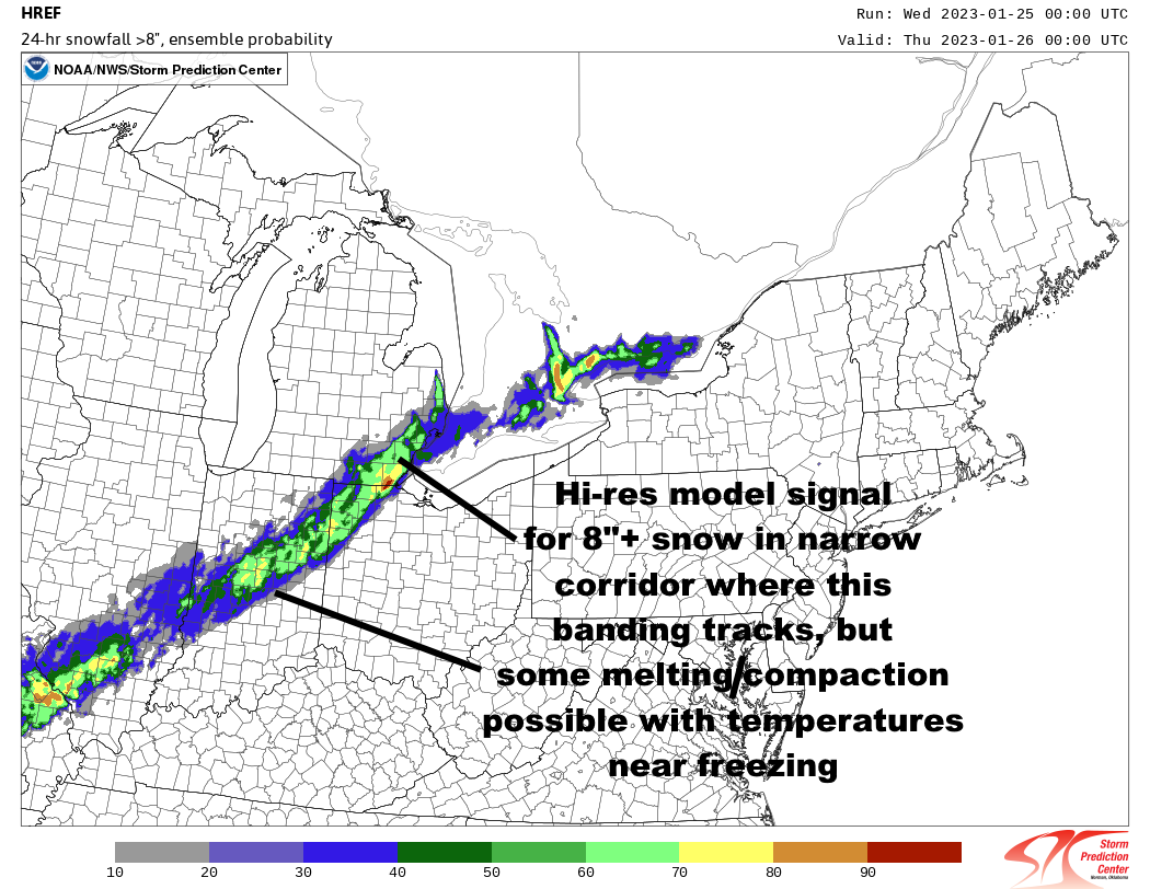
The hi-res models are really barking that the deformation band that cranks from parts of central and eastern Indiana into northwest Ohio, southeast Ohio, and southern Ontario during the day Wednesday will pack 1-2" per hour rates, with forecast soundings that support heavy snow with large flakes:

.thumb.png.e11c062808f3b1698b03193a1877799b.png)
.thumb.png.393768f0f485f4a8999f258eb4d10e16.png)
The hi-res model consistency (and slight ramp up this run) of the deformation band placement and potential for over 6" with it has been relatively impressive, so we'll see if they're sniffing something out.
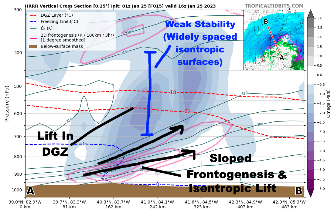
It's worth noting that the synoptics behind this are nuts:
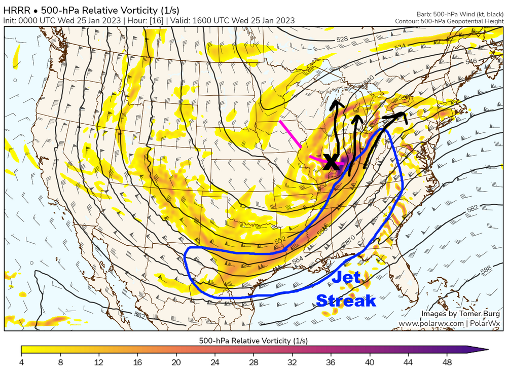
Strong divergence in the left-exit quadrant of a jet streak ahead of a sharp negatively tilted shortwave, with a zone of strong warm air advection and low to mid-level frontogenesis beneath this to help squeeze out precipitation:
.thumb.png.8bdbb688eeb4386c2879358dccde5007.png)

Temperatures will be at or perhaps slightly above freezing for most of this snow so ratios won't be great, but heavy snow rates with large flakes are likely to occur in any mesoscale banding that develops within the broader deformation zone on Wednesday.
-
3
-
6
-
-
4 hours ago, RogueWaves said:
LOL, Watches expanded S in Ohio. Which office is winning that battle??
ILN largely did that due to concerns that snowing an inch an hour during the commute in Cincinnati and Dayton would be a mess as opposed to any confidence in reaching warning criteria snow totals. We'll see if it pays off, as if it trends north the thump of snow would occur north of Cincinnati. Not everyone would've issued that watch but I appreciate the reasoning. I didn't have the confidence to go with a wider watch for "impacts" into our CWA today, though some models certainly suggest it's not impossible that northern OH gets good snow even east of the low track. Front end thumps can be sneaky when the forcing is robust. I'm just excited that it looks to snow half decently for a wide area, especially on the front end.
-
1
-
-
6 hours ago, dta1984 said:
What's your thoughts on the wind direction for les later in the week? Thought I saw mention of WNW in one of the cle discussions.
Looks to start northwesterly later Wednesday night and gradually turn more due west by later Thursday. There should be a decent period Wednesday night into the first half or so of Thursday that the fetch favors your area.
-
Slightly less than 1" new overnight pushing me to slightly less than 6" for a storm total. Should clear the 6" mark with the lingering activity this morning. Wednesday's system looks like a snow to rain to wrap-around/LES situation. It'll be quite spread out but the snowbelt should get a pretty decent amount between Wednesday morning and Thursday night.
-
Measured 5” here at 5pm. We’ll see how much we add overnight. Not nearly as impactful as the blizzard, but comfortably the largest snow of the season so far.
-
Just measured 5" here...will the appetizer drop more than the main course for parts of Ohio?
-
2
-
-
Nice over-performer underway. Pretty much no issues with the marginal temps whatsoever! It came in quick and started sticking immediately, and should hold at or below freezing all afternoon with this steady snow. Already a tad over 3" here.
-
1
-
-
Cute little system tomorrow into tomorrow night...it's progressive, but there is respectable jet support and moisture to work with, and lapse rates in and above the DGZ may support some slantwise convection for a few hours in the afternoon. Basically, the synoptic snow won't last too long and it will be on either side of freezing, but there could be a period of 0.5-1" per hour rates and large flakes that roughly comes up along or just southeast of the I-71 corridor beginning late morning in southern OH and getting into northeast OH in the afternoon. There's a period late Sunday night into Monday morning where lingering synoptic moisture and "cool" northwest flow may allow for some lake enhancement to flare-up in the higher terrain southeast of the lake. I'm guessing it's a general 1-3" with the synoptic snow...maybe a localized 4" lollipop if heavier rates impact the higher terrain where it'll accumulate best...followed by a coating to 2" of lake enhancement/upslope in the favored areas. I'm actually kind of looking forward to it! Though, that's more of a product of me liking snow and not getting much of it this winter.
-
1
-
 1
1
-
-
14 minutes ago, RCNYILWX said:
The pre-Christmas storm is definitely an example of impact based vs. criteria based WSW. We had that leeway in the past depending on the event, but it's gone more down that road. I'd say more often than not we still try to hold to issuing warnings for heavy snow with the 6"/8 hour and 8"/12 hour criteria in mind. Pre-Christmas was a special case because the combined impacts of blowing snow, high winds, and cold were fairly high end for the little snow we had.
Even though advisories are supposed to go away in a few years, we've definitely trended even more impact based for advisories. The thinking is that is there much difference between 2" of snow causing snow covered roads vs. 4" causing snow covered roads. The traditional 3-5" criteria probably was a holdover from the snow advisory when WWAs grouped in the various hazards that used to have their own advisories.
WSSI is an advancement in terms of impacts that would help reduce the subjectivity. We noted that it ran a bit hot the first few years, especially higher on the impact scale. An example is the Feb 1-3, 2022 event having top end "Extreme" impacts forecast south of I-80. It was definitely a solid winter storm, but not extreme if you scale it to truly historic events like GHD I and upper echelon storms like GHD II.
Some recalibration was done this winter to help with that. The hope is that it can be of more assistance in issuing Winter Storm Watches and Warnings in the future. There's also probabilistic WSSI in development as part of this process.
I suspect when advisories go away we'll see a bit more of a shift towards the "impact-based" paradigm, as when we only have the warning headline we may have to issue warnings when we think an event will be high impact, regardless of if it hits criteria. I'm curious to see if what becomes of advisories (the broad "plain language statements") are issued more like today's special weather statement, a soft headline that technically isn't a watch/warning product, which may also allow for more impact-based considerations. I've never loved having a set snow criteria for advisories, because as you said there are many other variables that can make a given amount of snow higher or lower impact.
Am hoping for more synoptic winter storms to test out the tweaked WSSI this winter...this isn't a bad look if it's correct:
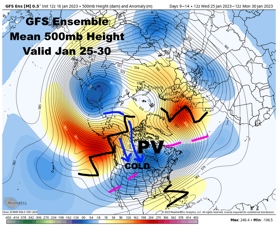

I think the western ridge is legit, but we'll see if we get that subtle little -NAO that can help push the PV south over Hudson Bay, which would get all of the subforum cold enough for snow in late January.
-
6
-
1
-
-
On 1/15/2023 at 8:55 AM, IWXwx said:
First of all, I know this is way off-topic for this thread, but who's gonna put me in AMwx jail?

That's interesting because at IWX, they are really promoting using "impact-based messaging" and I assumed that this is the mantra NWS wide. Maybe part of the problem is rigidity of following the criteria for meeting a particular product.
For example, at IWX the criteria for heavy snow is 3-5" for a WWA (or 2-4" at the forecaster's discretion), and greater than 6" in 12 hours or 8" in 24 hours for a Warning. In conversations I've had with their WCM, I got the impression that in the past, they may have gotten their wrist slapped for "overwarning" an event. For example, upgrading to a Winter Storm Warning for 5" of snow, even though there were exacerbating conditions such as blowing snow or glaze ice underneath the snowpack.
It seems that with impact-based forecasting, they've loosened up some and given the individual forecaster some leeway in issuing products. Just my point of view, maybe some NWS mets can chime in.
Sure. I believe the agency as a whole is pushing to highlight the impacts of winter weather more...you see this with the recent emphasis on snow squalls, with products such as WSSI that give impacts for more than just total snowfall, and in training I recently went through regarding winter weather stuff I got the impression that they wanted impacts to be considered when issuing winter weather headlines.
However, there are still a lot of different individual forecaster opinions along with varying philosophies from office to office. I can say from a verification standpoint, warnings are verified based on what gets put into Stormdata. Basically, warning level events or events resulting in fatalities are supposed to be entered. So if there's no warning out covering an event entered, the event was missed. If there is a warning out and no event gets entered into Stormdata, the warning is a false alarm. It makes it very hard for offices to "massage" the numbers (I don't necessarily mean cook the books so much as leaning a certain way if it's "close" based on what headlines were out...basically, less room to give yourself a buffer, which I don't think is the best when verifying a forecast). Some offices (including mine) are big on consistent Stormdata entries. If similar events have been written into Stormdata before they should continue to be entered...and vice versa if similar events haven't traditionally made Stormdata. We have a clause here that winter wx headlines can be issued based on impact, but when we verify it in Stormdata we need tangible evidence of "impact" from a given forecast zone...high standards to get included if amounts are sub-criteria...so, for us to go with the "impact based" headline (especially warnings...advisories can be a little looser) we need to be pretty sure that the aggravating factors will be significant. In the case of the December 23rd storm, at least in the CLE CWA, that was the case and everyone issued warnings.
-
2
-
1
-
-
The consistent light snow through last evening added another 1.5" here, so ended up a bit over 2" for the storm. It was a snow-filled day even if it wasn't all that exciting.
-
Measured 0.7” before 8am…some light accums since, probably over an inch total. It’s modest, but looks nice on the trees. Very fine flakes occasionally mixing with a bit of freezing drizzle at the moment.
-
Such a garbage system lol. At this point the highest terrain upslope areas may get 2-4"...maybe 5" near Chardon. The Chautauqua ridge in eastern Erie Co and Chautauqua Co may be able to get a bit more, but this is very unexciting back towards Ohio.
-
1 hour ago, Hoosier said:
Good post.
The southeast ridge usually seems to assert itself in Ninas in February, so I'd probably be nervous with southward/eastward extent in this sub. Could be a good month for a good part of the region though depending how things unfold.
Yeah I suspect the SE ridge tries flexing at times into February given La Niña climo and also the MJO working through the Indian Ocean and western Pacific late this month into early Feb which also teleconnects to a SE ridge. So, the amount of blocking (especially over Alaska and western Canada) may say a lot about how much the gradient can be shoved south into the sub forum in the face of that. I do think there’s a window where we’re all pretty cold and the storm track shifts far enough south for most to be in the game around the end of this month, but we’ll see how long that can last.
-
1
-
-
58 minutes ago, Chicago Storm said:
someone stole my thunder.
I only post like 4 times a year gotta make it count
-
3
-
2
-
.png.a87c96ed19cc4874fd9efd347db5aeb6.png)
.png.1f4b2a26f2d30a8ec5052bab69201ab9.png)

.png.65abd0fdf3bc5814eebf4a3ba43c10c5.png)
March 3-4 Potential Winter Storm
in Lakes/Ohio Valley
Posted
I've been trying to pay the most attention to both the ensemble means, but also looking at the various threshold probabilities (for both QPF/snow), individual members and some of the new percentile stuff on WxBell (WxBell really has some pretty nice stuff for the GEFS, EPS and GEPS) to get a feel for what the "favored" solution is but also for trends on the fringes. The EPS has been disappointing to me with this one as it's tended to be under-dispersive and following the op, but the GEFS actually had a good spread several days out when the op Euro/CMC were well south and I think it's encouraging that the last couple of runs have tightened up the spread a bit (and seem to be converging on a slightly more amped solution than the op). I feel like I'd lean towards the more amped solution, but I have seen northern stream confluence mess with these sub-tropical jet storms before so the less amped solution is still on the table for now.