

OHweather
-
Posts
4,887 -
Joined
-
Last visited
Content Type
Profiles
Blogs
Forums
American Weather
Media Demo
Store
Gallery
Posts posted by OHweather
-
-
Ended up with almost 3" of snow here on top of 0.10" of ice accretion. Was sleeping through most of the LES this morning, but that was significantly more than expected. Gusty winds and two days of milder weather opened up some water.
-
The final nudge for a warning was confidence in a solid tenth to quarter inch of icing followed by sleet and some snow/blowing. Just too much going on not to. Roads took some time to turn after the warmth earlier today, but right now are covered in a dense snow with a slick layer underneath. The ice on its own didn’t cause many tree issues, but as gusts came up after 10pm we got scattered reports of downed trees and some power outages. Not a true ice storm but impactful. Should be improvement into the morning where they get the plows out as the snow is tapering now in the CLE area.
-
This entire system is a mess between legit water concerns (already an ice jam release causing flash flooding in Vermillion) and the wintry aspect. I expect a healthy glaze of ice from Lake, Geauga, Cuyahoga and northern Summit points west along with 0.5-1.5” of sleet and 1-3” of snow tonight. Towards Toledo more snow and a bit less sleet and ice. Farther south less wintry precip but still a brief mix to a little snow later tonight. With the falling temperatures, I expect this to be a complete mess on the roads. We discussed some possible winter storm warning upgrades last night, not sure if it’ll ultimately happen or not but I think it’d be warranted for impacts this evening. People should not be on the roads after 6 or 7pm this evening in northern OH if they can avoid it.
-
50 minutes ago, NEOH said:
It is definitely a picturesque snowfall... very fluffy. Over 4" IMBY. Great call on this snowfall.
We've had a couple of "Cleveland specials" the last few weeks with lake effect/enhancement causing things to really overperform. Seems like a broad 2-5" from western Lake County and most of Geauga and Portage points west to eastern Erie County. Highest reports I've seen here are 6-7" in Westlake and parts of Lorain County. Quite a bit for a "snow showers and inch or less" forecast ahead of time...saw some properly snarky comments on social media about the forecast yesterday. It was tough but it's regrettable that certain things were overlooked ahead of time.
-
 1
1
-
-
Got another inch or so overnight, event total 3.8" (have 3.6" on the deck, but the few tenths from Saturday night partially melted yesterday afternoon). Not too bad. Very fluffy and with a calm wind snow is still sitting on the trees.
-
1
-
-
Have gotten about 2" here this evening, one more squall to go. Counting the dusting we got last night into this morning slightly under 2.5" for an event total. Just drove home from southwestern Cuyahoga and clipped the southern edge of a band that's sitting along and just east of I-77, is snowing good under it.
-
41 minutes ago, vpbob21 said:
Got about 3.5" here. Nice surprise!
I feel like some of your better LES events over the years in Erie County have been surprises like this when most of the lake is frozen but a crack opens up east of the islands. Glad you got a taste of the fun this morning!
-
A few reports of 2-4" so far out of Lorain County...likely that eastern Erie County (near the city of Huron) got a few inches too as a band dumped on them this morning and a webcam at the mouth of the Huron River looked really intense for a while. The mesolow has edged east and weakened a bit. Those of us on the east side need the feature to unravel a bit more, as it's messing with the wind fields and is keeping our flow east for the time being. The mesolow should open up within the next couple of hours and we should get a more W or WSW push of wind west of the remnant convergent zone ahead of the approaching vort max, so I think we'll see the remaining convergence push towards western Cuyahoga and Summit this afternoon though it may not get east of there, as the flow is weak and I suspect it'll maintain some tie to the large area of open water east of the islands. This remaining convergence should be a focus for more organized snow through this afternoon and evening, with a significant uptick likely this evening. I suspect the greatest additional accumulations will be in parts of Lorain, Medina, western Cuyahoga and into western Summit where another few inches seem possible under any more focused band.
For the rest of the primary snowbelt, as the mesolow weakens winds should turn more north/northwest. While the water is icier east of Cleveland there's still some open water and a lot of cracks so there will be a flux. We should see some lake enhanced snow develop and move into the rest of the NE Ohio snowbelt later this afternoon into this evening as synoptic support peaks. It will be a fluffy snow and may briefly have some intensity this evening so it could still produce a few fluffy inches in the higher terrain in eastern Cuyahoga, southern Lake or Geauga.
It has largely been steady flurries here this morning, we picked up a few tenths through 9 AM from last night into this morning...it's been melting/sublimating faster than it's falling the last couple of hours.
-
Just woke up and looked outside and at the radar myself…just a dusting down here last night but it did snow. Fascinating radar and will be a fun evolution to watch today with a mesolow forming over Lorain County over the last couple hours. Convergence is setting up west and south of this feature. Best guess is this feature edges east through this afternoon and weakens a bit, but still focuses snow west and south of it. Already good moderate snow out west and instability, moisture and synoptic support improve markedly this afternoon and evening. I think parts of Lorain, Cuyahoga, Medina and Summit Counties get dumped on through tonight but also think that as far west as eastern Erie County and as far east as Lake, Geauga and Portage can get at least a chunk of accumulation too at times. I’d have at least advisories out for all of those counties outlined at the least and feel pretty good about parts of the first four I mentioned getting warning criteria amounts through tonight.
-
Just had a quick shower of light mixed stuff with the front earlier today...still not cold enough for a lake response yet and there was a drier wedge of air right behind the front, but it should get cold enough for minor lake effect to develop this afternoon into tonight into the primary snowbelt with a largely west flow. Think a dusting to locally 2" is possible later this afternoon through this evening, focusing on the higher terrain of the primary snowbelt.
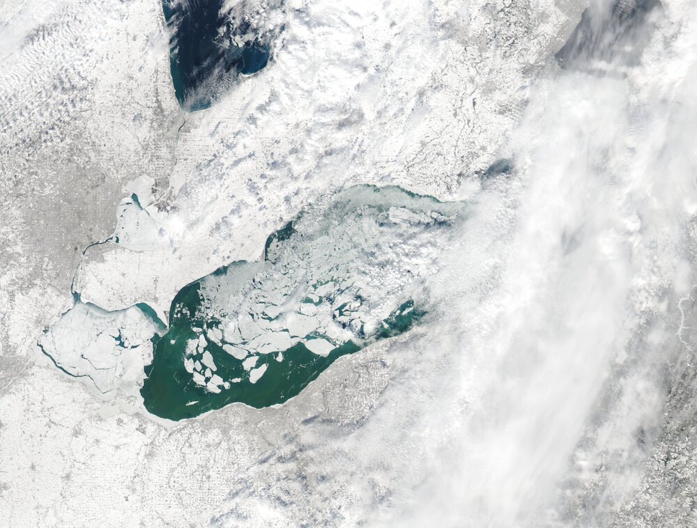
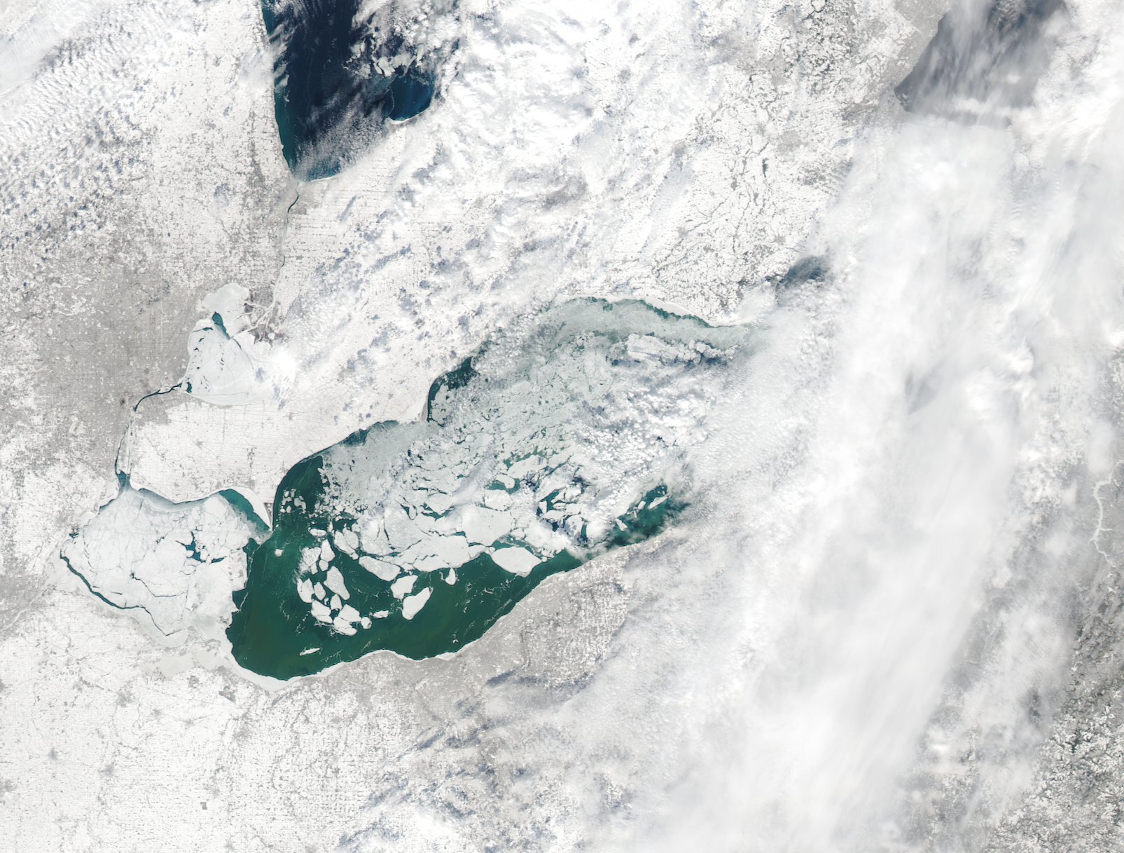
I'm still rather intrigued by Sunday afternoon and evening...getting a few glimpses at the central basin through the clouds this morning and it's more open than the above image. Actually looks like little ice east of the islands in the central basin. With plenty of synoptic support Sunday afternoon and evening and a light W/SW flow initially turning more NW Sunday evening, expect lake effect to develop over the lake and near the central lakeshore and then push inland Sunday evening. I still think the amount of instability and synoptic support may support decent accumulations, perhaps enough to warrant an advisory or even close to warning somewhere on either side of Cuyahoga County. The RGEM and Euro are picking up on this somewhat...the NAM is getting closer. Most hi-res models still aren't properly handling temperatures over the lake though (colder than the surrounding land). My main question is where it sets up with a rather light flow, but expecting it to focus on the largest area of open water in the central basin and then push southeast Sunday evening as the flow goes more NW, before focusing back up the eastern lakeshore into Monday as the flow turns westerly.
-
Suspect this weekend will be sneakily snowy downwind of Lake Erie...cold front moves through early Saturday with some snow showers. Suspect that mainly light but also very fluffy lake effect flares up Saturday into Saturday evening as 850mb temperatures drop below -15C, with enough lingering synoptic moisture to help the situation. Seems like any lake effect Saturday - Saturday evening will be pretty low-topped, but temperature profiles will favor very good snow growth by the afternoon and evening. With a fairly light WNW flow, could see a few bands from Cuyahoga County into the primary Snowbelt. Feel like a general 1-3" is likely between the front and lake effect late Friday night through Saturday night, could locally be a bit more if some organized bands develop.
Sunday afternoon through early Monday would probably be a honking lake effect set-up if the lake were wide open with a very nice upper level trough moving right overhead. Even as it is, there's really good synoptic support for a time late Sunday into Sunday night with a light west-northwest flow and 850mb temperatures near -20C. Inversion heights look to rise to 8-10k feet with some synoptic moisture and perhaps some upstream connections. The light flow may favor mesolow formation over the lake and may also suggest the heaviest snow falling closer to the shoreline than normal, with temperature profiles again suggesting very fluffy snow.
I suspect models are underdoing moisture flux and hence QPF as there's plenty of wide open water east of the islands and off of Cleveland, with the rest of the lake mainly ice covered but with plenty of cracks. The strong southerly winds through Friday will help push that ice around some more. The synoptic set-up would scream warning criteria snow Sunday afternoon through Monday morning in the Cleveland area and parts of the Snowbelt with a completely open lake. Even as it is, I suspect someone may get a surprising amount of fluffy snow out of it.
-
Lake effect surprised last night…2” in Reminderville but have a couple spotter reports out east of 4”
-
21 hours ago, OrrvilleWX said:
I wanted to measure what I got here in Orrville. It’s just blown around so much. From this afternoon until now. It seems like we’ve picked up 5-6”.
Also, thanks for the replies. Don’t comment on here much. Always been a big fan of weather and enjoy following these events. I’m just a novice, so I apologize in advance if I ask any dumb questions. Thanks again.Your analysis of the radar starting to fall apart was spot on. Lighter snow lingered for a while, but the heavier stuff was on its way out. There aren't any dumb questions in this field!
12 hours ago, NEOH said:Looks like CLE reported 8" as of midnight with a depth of 2"
 . With the windy conditions this is a storm they will come in with a low measurement.
They came in with a 9.5" storm total...which I think is slightly low, but within reason. That depth in the daily climate report is the 7 AM number and they were up to 10" this morning. Blowing/drifting caused a lot of issues with measuring and caused the snow on the ground to start compacting last night. We had some public obs of 15"+ when all surrounding obs were more like 10-13"...those reports didn't get sent out, but did send out a number of LSRs from the public/social media of believable amounts near or just over a foot...on the other hand I do think some measurements came in low due to snow blowing away/compacting, anything under 8" in our area is too low. We will hopefully add up all of the 12 hourly spotter obs tomorrow and send those in a PNS.
Best guess here was a little under a foot when I left this morning with about an inch additional since...so, close to a foot here. Another good synoptic storm in the books! Roads were still trashed early this morning with little traffic but still a few slide offs on 480, but quickly improved towards midday.
-
50 minutes ago, OrrvilleWX said:
Radar is making looking like it’s starting to die out or is it just me?
The last slug of heavy stuff is going to exit the next couple of hours. It'll be light the rest of the night. Think probably another 2-3" left most spots (maybe 4" far eastern OH into PA, and more like 1" or less in NW OH).
-
1 hour ago, tim123 said:
Just got a 2022 awd stinger great car. Here in rochester ny looking to get near 2 feet
Hopefully you properly splurged and got the GT2 as well. I have a 2022 GT2 AWD and they managed to upsell me on the Scorpion addition because I was having a pre mid-life crisis in NJ and wanted the car. The Ford Fusion I had for a few years before this was a perfectly fine car but this is by far the best car I’ve owned…and how it performed today was a pleasant surprise. Guessing AWD and 2022 technology FTW.
Beyond that, had about 2” this morning when I left at 7am. Took a few half hearted measurements and think I’m near 8” now…about 6” in the last 12 feels right. Some blowing and drifting. After getting the pack down to several dense inches yesterday it’s deep out there again.
-
1
-
-
Fun drive. Was a little worried about how my Kia Stinger would do in real snow…surprisingly well even with all seasons on it. Guess having an AWD with the tech they put in these things nowadays helps, even if I start getting it sideways it whips me back into line pretty quick. Now to make the same drive at 5am after a night of continued snow.
-
3
-
-
Think areas that stayed all snow in north central and NE Ohio will overperform some. Seems like 4-8” so far where it’s stayed all snow and probably a good 5-9” more with snow lingering into early Friday now. Canton to Youngstown have seen no snow yet lol. Sharp cutoff down there though they should flip and get a few inches, with the current mix turning into a mess as it freezes tonight. Roads suck, wish me luck on my trek from Brooklyn Hts to Reminderville!
-
2
-
-
4 minutes ago, Floydbuster said:
Yeah local mets here in Cleveland keep talking about the mid-day Thursday "second wave" being WAY more than expected. It's currently over Texas, of course.
This is some lazy analysis using the HRRR, but check out the trends with the location and strength of the second wave 12z tomorrow...trending more amped. Precip shield edging a bit northwest as well. And, the high is backing off slightly in newer runs. May be a legit trend.

-
Starting to sleet a bit here. 0z NAM, hi-res NAM and HRRR really juiced and snow longer into tomorrow night. Could be the last-second amped trend we often see. As @TheClimateChanger mentioned the result would be a huge storm. Was worried my AFD on Monday was a little too hype-y talking about pushing snow removal infrastructure past it's limits if we stayed all snow and got 12-18" in the Cleveland area, but those models would bail me out. The 18z Euro trended a bit that way too with more snow into tomorrow night so perhaps the idea has some legs.
-
1
-
-
32 minutes ago, Jonger said:
What radar are you using.....this has been hard to track due to DTX outage.
If you have radarscope, it has the terminal doppler from DTW. It's not the best but can help when DTX is down.
-
Anyways, overall trends have been for wave 1 to be a little more amped, resulting in NW Ohio seeing more of that QPF as rain today, and for wave 2 to be similar or slightly flatter. This should keep the Cleveland area just snow on Thursday, though Akron/Kent/Medina/Trumbull Co will probably find a way to sleet at times still when the WAA aloft really rips. It just always happens. There has also been a modest trend for the second wave tomorrow to be a bit slower. A few implications:
1) A little less overlap in the axes of heaviest snow with each wave in NW Ohio, leading to a more "ho-hum" 8-14" or so type event instead of the historic storm for Toledo that was on the table. Could still push top 10 2-day snows there (only needs to go over a foot for that). Even Cleveland loses a bit more QPF to rain, though they weren't slated to get as much from this first wave (and should still change to snow and get some accumulation this evening through tonight)
2) The flatter second wave should keep mixing well south of Cleveland, the lakeshore counties and snowbelt on Thursday, and will probably mainly be snow and some sleet in Akron. This brings the axis of heavier snow with the second wave a bit farther south. Still think Canton and Youngstown points south lose a fair amount of QPF to sleet or freezing rain through Thursday...however:
3) The somewhat slower trend with the second wave allows a little more QPF to fall into Thursday night, when the whole area will be cold enough for snow. So, this will help boost totals a bit more down towards Canton and Youngstown.
Feel like a rather safe 8-12" is a decent call for NW Ohio, Cleveland and the lakeshore counties and Snowbelt. Can't rule out the second wave trending a bit more amped and overperforming but feel like any 12"+ amounts will be more the exception than the rule. With falling temps through the event and wind to blow the snow around roads will be bad from tonight through Thursday night. Akron I'd be more like 6-10" as I still think they lose a bit to sleet and lower ratios, but a good storm and a dense accumulation...roads won't be pleasant. Canton/Youngstown I'm thinking it's more of a 4-8" or 5-9" with more sleet and probably at least some freezing rain. Should easily warrant a warning, and I'm hoping the early 12z stuff coming in a bit snowier down there will help nudge the headline decision in that direction.
-
 5
5
-
-
16 hours ago, LakeEffectOH said:
Does anybody know why Lake and Cuyahoga county are under a winter storm warning while a winter storm watch is still in effect for Geauga and Ashtabula county. For sure, CLE is not thinking of the possibility of putting these counties under and advisory...
Was not in the office yesterday or today...but from what I gathered the reasoning for holding watches south/east of Cuyahoga and Lake was more time to refine the exact accumulation forecasts, start times, and collaboration with ILN and PBZ who wanted to hold watches outside of the "slam dunk" areas farther north and west where it will just be snow and start sooner. The goal is to issue warnings 12-24 hours out unless there's overwhelming confidence and it's a higher-end situation so they did have time to hold the watches another cycle yesterday. With that said, I will agree to disagree with our current advisories from Knox-Holmes-Stark-Mahoning.
-
1
-
-
Anecdotally, I don't trust this system not to mix all the way up to at least Akron, OH, which the Canadian/RGEM insist on. And maybe the Canadian models are doing better with the PV over Canada. That's my analysis for the day
")
But for real, I think how the PV interacts with the storm is quite important here for wave 2. With a jet streak to the north providing plenty of divergence aloft and with the precip largely being driven by warm air advection processes...to go along with what should be a lot of latent heat release from convection in the Gulf Coast states and from the anomalously high PWATs getting wrung out as the moisture gets lifted over the front, I feel like if the PV doesn't press down more there is room for last second northwest bumps with the wave on Thursday. If the PV presses down more it will overwhelm these processes, but if it holds steady or backs off slightly I'd expect a bump back NW. Can argue we've stopped the trend of the PV pressing down more in recent runs at the least.
-
2
-
3
-
-
There’s been a continued modest colder trend on guidance overall. Still do not fully trust it until some more models take the mixing out of our area with this kind of system, but for those of us looking for a south trend to stay all snow there’s reason for hope. That map Tanchak posted will almost certainly not verify though. Looks like straight GFS.
-
2
-
 1
1
-

Northern Ohio Obs/Discussion Part 2
in Lakes/Ohio Valley
Posted
Another slop system coming Thursday into Friday. This one seems like it will be the "weakest" of the last 3 but could still well net advisories for much of the CLE CWA. Was on the forecast today and kept NW Ohio and the lakeshore all snow, but had some mixing as far north as slightly north of a Marion-Mansfield-Akron-Warren-Meadville line. Could see that moving a bit as we get closer. The snow through Thursday night will be lower ratio and we may not get organized banding, it could just be prolonged light to moderate precip. Have 2-4" in the grids through 7 AM Friday north of the line I just laid out and 1-3" farther south along with up to 0.10" of freezing rain. If we get into the lingering wrap-around / deformation snows on Friday as 850mb temps crash, there could be enough lake enhancement to add a few more inches of fluffier snow off the lake on Friday, as it should be open by then. We'll see how it trends.