

OHweather
-
Posts
4,887 -
Joined
-
Last visited
Content Type
Profiles
Blogs
Forums
American Weather
Media Demo
Store
Gallery
Posts posted by OHweather
-
-
Saw some graupel a couple of times yesterday. As a band of heavy precip pushed onshore last night, it changed to mainly graupel/snow for a time from Lake and parts of Geauga Counties points east. Actually covered I-90 and SR-2 with slushy graupel and caused a few accidents in Lake County...a few reports of an inch or so in the highest elevations in NE OH and NW PA. I guess we're on the board for the season?
-
Seems like a good shot for some of us to see flakes Monday night into early Tuesday as a pretty good surface trough axis pushes through, with some moisture from Lake Michigan likely allowing for some showery precip to occur anywhere across northern OH. A cold/moist cyclonic flow then continues through midweek, so we may see some showers mixing with flakes/graupel at times through Tuesday and possibly into Wednesday. Lake effect off of Lake Erie looks focused up the eastern lakeshore through Monday evening before pushing into at least the primary snowbelt by Tuesday morning as winds go more west to slightly north of due west. There may be a nice burst of lake effect in the primary snowbelt late Monday night/early Tuesday as the trough pushes through and the band that will initially be focused up the lake pushes onshore. 850mb temps of -4 to -6C are probably a bit too warm for a notable threat for accumulation, but if there's a nice burst it's possible some hilltops get some slushy/grassy accumulations by early Tuesday.
Getting some pretty nice color right now, which hasn't been a given the last few years.
-
This event has seemingly trended about as favorably as possible for a long duration, significant lake effect rain event. While I think the heaviest amounts are near I-90 from extreme northeast Cuyahoga County points east to near Buffalo up the lakeshore, activity gradually shifts inland Tuesday and Wednesday so parts of the Cleveland metro and Geauga County will still get some, and a locally heavy band may set-up in northern Cuyahoga and northern Geauga at some point Monday night or Tuesday...with activity likely spreading farther inland Tuesday night into Wednesday. Our QPF grids this morning added up to 3-6" for a large chunk of the primary snowbelt from today (Sunday) through Tuesday night, and some hi-res models have consistently advertised locally even higher numbers than that with any persistent banding closer to the lakeshore and the I-90 corridor. While it's been a dry summer, eventually it's too much rain so we may get the rare lake effect flooding in some spots over the next couple of days.
This would have been quite a snow set-up if it were cold enough.
-
A snowstorm in winter or something out of season? If it's the latter, early or late?
Out of season, preferably late. You know it's out of place and the last one, so I always find myself extra invested in the late ones.
Wet snow, dry/fluffy snow, or something in between?
Something like a 10-12:1 ratio, which is probably in the in-between
Light/calm winds, or windy conditions while it's snowing?
Gentle dendrites falling in light winds is a site to behold, but for this exercise, windy please.
Continuous snow, or do lulls not matter as long as amounts end up as expected?
Continuous
12" in 12 hours, or 18" occurring over 36 hours?
12 in 12
Bitter temperatures, or just cold enough to stick well during the storm?
Just cold enough, but at the end of the day it won't be mild either way so whatever gets the job done
Storms on holidays/your birthday/some other meaningful day, or are dates irrelevant?
It's a bonus if it snows during the holidays, but I won't enjoy a storm that's not around the holidays any less so we'll go with irrelevant
If living in a lake effect area, would you rather have a synoptic or lake effect storm of the same amount?
After living in Nor'easter country for a few winters, definitely synoptic of the same amount. Lake effect is great, it more than doubles our annual snowfall around here and is still quite prone to surprises, good and bad. There's a lot of excitement there. But lake effect is almost always higher ratio so compacts very quickly and typically, the highest amounts are quite localized. Between typically being a heavier snow and a whole region getting it, synoptic storms are just more impressive and enjoyable overall...not that I have anything against a surprise LES jackpot every once in a while.
So, my perfect storm has to be January 31-February 2, 2021 in NW NJ. We got 30" of snow where I was, with some surrounding towns in the hills getting a few inches more. About 26 of that fell between late afternoon on the 31st and evening on the 1st with no lulls, and even after that a persistent light snow with no true breaks continued for another day and added a few inches. Winds were gusting 30-40 MPH for several hours, coinciding with the heaviest snow which was 2-3" per hour for several hours. Temperatures were in the 20s. Our average ratio for the storm was 12-13:1, so somewhat fluffy for the East Coast but still rather dense compared to a lot of snow events in the Great Lakes. Nothing else I've seen is extremely close to all of that added up...I've seen that total (over a much longer duration), those rates (but in localized, fairly short-lived LES bands), and snow in that amount of wind, but not all together and the storms in which I've seen totals that high had much higher ratios.
An honorable mention is April 23-25, 2005, when my location east of Cleveland saw 20" of snow in about 36 hours with no true breaks. Temperatures were 32-34 the whole storm with little wind. Trees were starting to leaf out and there was quite a bit of damage. That's likely my second favorite behind the NJ storm.
-
 2
2
-
-
Looks like a pretty classic lake effect set-up coming Sunday night through Tuesday night/early Wednesday with a deep trough, plenty of moisture, and well aligned flow oscillating between WSW and NW through the event. It'd be a solid warning criteria snow event in 2 months. As it is now, most of NE OH and NW PA could use the rain so it's mainly beneficial as long as someone doesn't get the several inches the Canadian models are trying to suggest...the instability looks deep enough at times Monday into Tuesday for thunder and maybe some small hail with the most intense bands. Probably will be a waterspout fest on the Great Lakes in general too. Fall is arriving on time this year.
-
2
-
-
1 hour ago, Speedskater said:
There is a big sailboat race regatta in Cleveland. It was scheduled to start Wed. June 15, but lack of wind delayed the beginning to Thursday morning.
Any thoughts on wind and waves Thur, Fri, Sat & Sun, during the day?
Hopefully we don't go too far the other way...suspect it'll be close to small craft advisory conditions Friday and Saturday... My guess: For Thursday, SSW winds in the morning veer towards the WSW in the afternoon behind a cold front at 15-20 knots. Waves 2' or less in the morning, maybe more 1-3' in the afternoon. Friday WSW winds near 15 knots, waves 2-4' in the nearshore waters. Re-enforcing cold front moves through Friday night turning winds NNW. Saturday NNW winds 20-25 knots in the morning gradually subsiding through the afternoon. 3-5' waves all day, closer to 5 in the morning, closer to 3 by early evening. Sunday high pressure starts building in...NNW winds 10-14 knots, waves 1-3'.
-
85 knot gust at Fort Wayne
KFWA 140245Z 36064G85KT 1/4SM +TSRA SQ FEW014 OVC030CB 24/ RMK AO2 PK WND 32041/0230 LTG DSNT ALQDS RAB29RAEMMB39 TSB18 CONS LTGICCG ALQDS TS ALQDS MOV SE P0000 T0239 $
-
3
-
-
SPC definitely seems to be leaning into those cells over southern WI growing upscale and taking advantage of the environment into this evening with that moderate upgrade. With that said, they also didn't trim the ENH at all (in fact, at least in the Cleveland area, they may have expanded it slightly farther northeast with this update). The stuff over Wisconsin, if it grows upscale, will dive SE into extreme SW MI, northern/eastern IN and into western OH, so I wonder if they're thinking another MCS tries developing tonight a litte farther north/east.
That cap is probably breakable in northeast IL, but the activity over WI needs to start growing upscale pretty soon or else it may not do it into northeast IL.
-
The models are still inconsistent with how they are handling/near term convection and how that impacts what happens this afternoon and tonight. The instability gradient will gradually shift east/northeast today and tonight, so the later we go before we see attempts at new upscale growth, the farther east/northeast the threat may play out.
Seems like particular points of uncertainty involve how the ongoing activity currently over MN and northern IA, along with the rain over MO. If the rain over MO holds together and is able to eventually cause new storms to develop over the Ohio Valley this afternoon, that will slow the advance of the warm front and shave off the northern/eastern extent of the threat into tonight. Some CAMs have consistently shown that, though given how weak the activity is now and warming mid-level temps farther south we'll see if that can develop into much.
The best synoptic forcing actually moves through the upper Midwest late this afternoon or evening and into the Great Lakes tonight. That will probably try to spark new convection along the instability gradient/warm front that would have a good shot at growing upscale, but the current activity over MN/IA adds quite a bit of uncertainty. That activity may become more surface based through this afternoon as it tracks towards the southern Great Lakes, and if that happened could grow upscale enough to either limit or delay the development of evening convection over the Upper Midwest. That's what the 12z HRRR did and why it suddenly shifted the derecho looking thing farther northeast and a few hours later. The 12z FV3 takes it to the extreme and actually makes the ongoing activity the dominant MCS and doesn't develop much behind it later today over the upper Midwest. However, if the ongoing activity stays elevated and lifts out before really growing upscale this afternoon, it could point to new initiation earlier that would probably dive farther southwest into this evening.
Will probably need to watch trends for at least a few more hours before truly ruling out any of the shown solutions.
-
1
-
 1
1
-
-
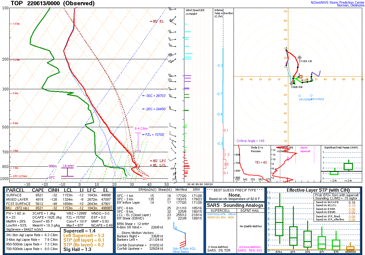
It's hard to overstate how thermodynamic the instability will be Monday and Monday night...you've got this pristine EML advecting in:

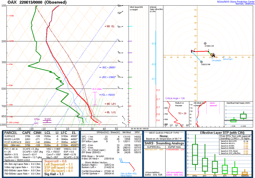

This impressively rich low-level moisture will be advecting into the Ohio Valley, southern Great Lakes, and Upper Mississippi Valley beneath the advecting EML:

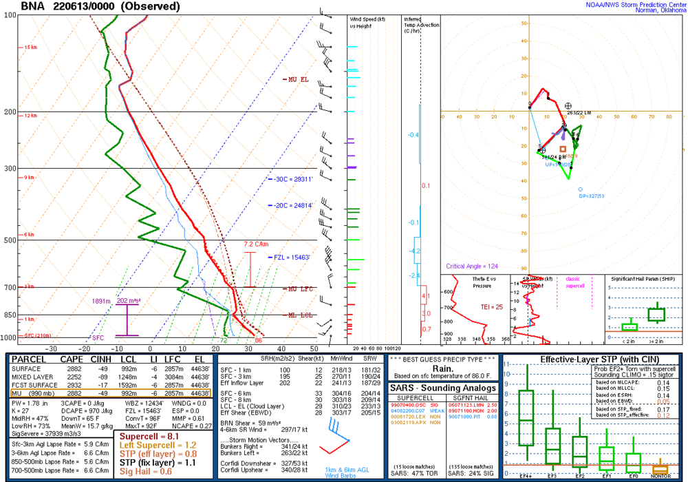
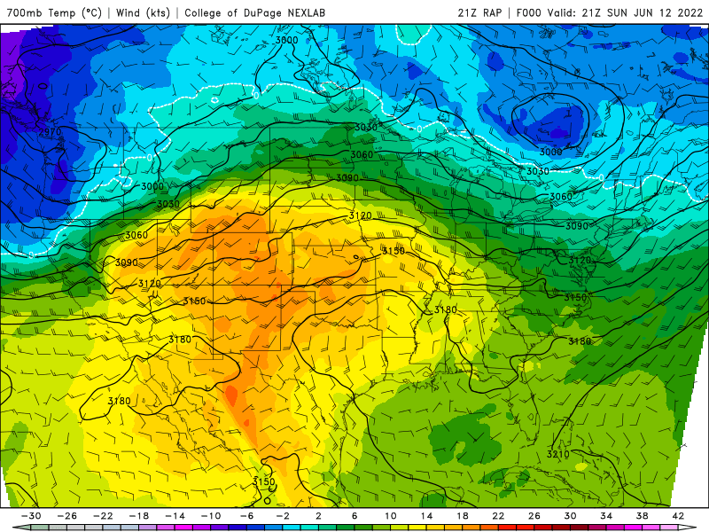
Despite the outstanding thermodynamics, the synoptic forcing is fairly modest (some right-entrance support over the Great Lakes) and at the base of the EML will be very warm 700-850mb temperatures acting as a cap:
The cap will be breakable in a narrow zone along and just north of the warm front...but with weak synoptic forcing, more robust convective development and subsequent upscale growth will likely be heavily tied to MCVs leftover from tonight's convection moving out of the Plains. A strong MCV will likely spark a robust subsequent MCS from the Upper Mississippi Valley into parts of the southern Great Lakes, mid or upper Ohio Valley, central Appalachians and perhaps eventually the Mid Atlantic. Given the thermodynamics and shear in place, the potential would exist for such an MCS to produce enough wind damage to be considered a derecho.
However, CAMs so far struggling to agree on a solution. This is likely due to how sensitive the set-up is to tonight's upstream convection and MCVs it leaves into tomorrow (along with perhaps some modest strengthening of the upper level jet streak glancing the region), along with multiple forcing mechanisms and a rich environment to work with. There may be multiple MCVs, and some modest lift feeding into the right-entrance quadrant glancing the region may also aid some in allowing for convection that initiates to grow upscale:
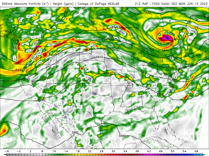
Can note the multiple subtle vorts/perturbations drifting out of the Plains into the Upper Midwest and Great Lakes as a result from tonight's convection in the Plains...these will likely be very tied to where new activity initiates on Monday.
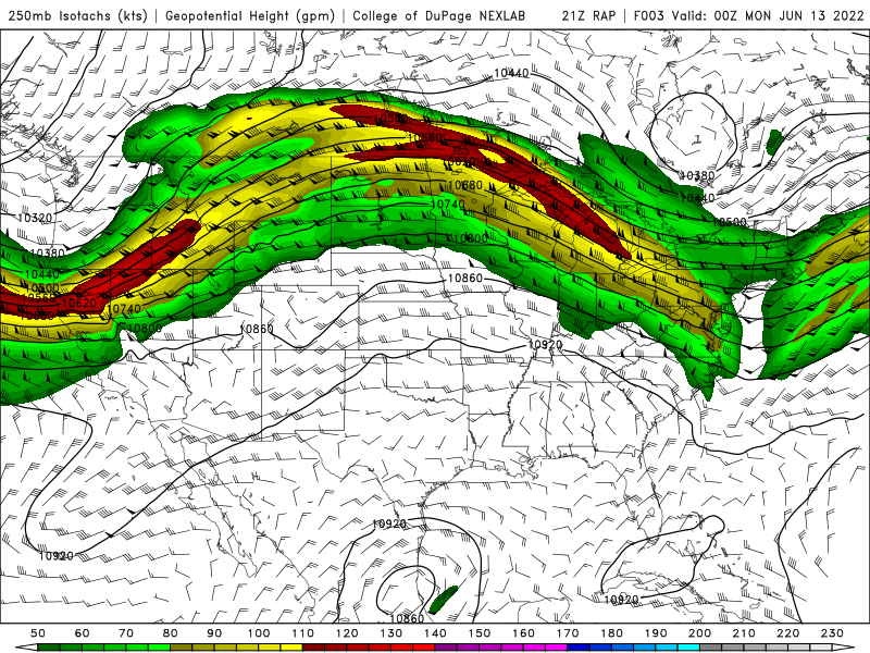
Can also note the right-entrance quadrant of a jet streak glancing the region, along with some hints that whatever upper level outflow occurs from convection over the Upper Midwest or Great Lakes may positively feedback with that for a time.
If multiple rounds initiate at about the same time Monday afternoon or evening, there could be enough competition to lower the potential for any one cluster to turn into a particularly long-lasting and potent wind producer.
Overall, my gut feeling is that at least one cluster will be dominant enough for a time to produce a pretty good swath of wind damage, but this could happen anywhere from the Upper Mississippi Valley to the lower Great Lakes, mid and upper Ohio Valley, central Appalachians or even Mid Atlantic between Monday afternoon and Tuesday morning. Potential exists for a higher-end event to be sure, but several ways it's at least somewhat limited. The MCV running east/southeast quickly may cause initiation earlier than optimal towards the Ohio Valley, slowing moisture/instability return farther north and also not taking full advantage of the environment coming together. Multiple areas of initiation at the same time could limit longevity of anything really potent, as there'd be too much competition eventually as stuff grows upscale. The greatest potential for a derecho to playout would be if initiation occurred mid-late afternoon in the Upper Mississippi Valley with one relatively dominant cluster and little out ahead of it, with the activity spreading through the southern Great Lakes into the evening and into the mid-upper Ohio Valley late evening or towards the overnight.
Given rich theta-e air feeding in from the southwest through Monday night, if we do see one or more MCSs producing robust cold pools, back-building and flash flooding may locally become a problem as the moist and unstable air would get lofted over the shallow cold pools by the low-level jet overnight, possibly causing back-building.
Any initial cellular convection would have a large to perhaps very large hail risk given the robust EML and huge instability...some tornado risk too, both with any initial supercells and with any more robust bowing segments that may play out as stuff grows upscale.
-
7
-
7
-
-
Ended up measuring slightly under 3" when I walked out the door at 7 AM...the burst that moved through after I left likely pushed the total a bit over 3". It was an interesting drive west along 480 to Brooklyn Heights, alternating between heavy snow and graupel, with the roads covered in many areas. They were out plowing. Some of it survived the afternoon on the ground.
-
Didn't really stick at home yesterday, but did immediately to my north/west and had about 1" at the office in Brooklyn Heights. Drove out to Ottawa County in the evening and there was 1-3" the entire way through Sandusky, before dropping off to the west. Most was in parts of Lorain and Erie Counties.
Just woke up to about 2" of lake effect this morning, which was a surprise...covering everything, including a lesser amount on pavement. Very scenic.
-
Had a little over an inch here this morning when I left. Was coming down hard enough to make the roads a bit slushy along 480 and 422 in eastern Cuyahoga County around 6:30. And as is typical this late, not a trace left by midafternoon. A bit of a surprise, surface temps dropped to 32-33 pretty quickly as steady precip came in and allowed much of it to fall as snow.
-
A little over 1.5” here yesterday (about 0.5” in the morning that melted, then a little over an inch in the afternoon that started melting). 3.5” last night into this morning. So at roughly 5” for the event, but roughly 3 on the ground.
-
Ground is covered here as well, though just a few tenths so far. It’s looking like a nice burst will drop in from the NW later this morning and will give it a go to accumulate during the daylight hours at the end of March.
Trend has been for temperatures to drop a bit quicker into tonight allowing good lake/upslope enhanced snow to kick in this evening into Sunday morning for a good 12 or so hour period (a bit longer in NW PA and SW NY where the deeper synoptic moisture pulls away slower) before activity tapers to lingering multi-banded LES that may linger through early Monday, especially downwind of Lake Huron into PA. The temperature profile will favor very efficient snowfall by later tonight with 850mb temps dropping to -15 to -18C, near climo mins for this late in the season, with some lingering moisture below 800mb allowing for some fluffy accumulations to continue under any organized bands through Sunday night.
Given a better shot at some accumulation today and a pretty good window tonight into Sunday morning, feel the higher terrain will do quite well. Think the current headlines that were thankfully issued just before the 11th hour are fine, though northern Geauga will get awfully close to needing a warning and given how well these areas do in a lake enhanced/upslope situation with a WNW flow such as tonight, northern Medina, Summit, and Portage may get a few inches too and push advisory criteria amounts.
-
Not that we want it, but it's looking like a fairly snowy weekend especially in the higher terrain east of Cleveland, through NW PA and southwest of Buffalo. A couple of troughs move through during the day Saturday and will likely cause upticks in rain/snow (mainly snow in the hills, but may mix with rain in the lower terrain as the boundary layer will be fairly "warm" during the day Saturday). There's a deep enough layer of moisture and steep lapse rates to go with it, so the snow may be bursty at times during the day Saturday and could stick a bit in the higher terrain.
However, the best accumulations will occur Saturday night into Sunday. A couple little spokes of energy move through, one Saturday evening and another late Saturday night into Sunday morning and will likely bring relative upticks in snow. It should change to all snow fairly quickly Saturday evening and begin accumulating in the hills better around sunset, with ratios improving overnight as the DGZ lowers and surface temps drop well into the 20s. The burst in the evening will be more synoptically driven with a bit of lake enhancement/upslope with 850mb temperatures falling from around -8C to -12C by 2 AM Sunday, and could be moderate to briefly heavy in the higher terrain. By early Sunday 850mb temperatures drop to around -15C with the DGZ lowering enough for significant lake enhancement/upslope. With a well-aligned WNW flow and lake-induced instability up to 5-7k feet, lake to 850mb differentials of around -18C, good upslope, some upstream connections and synoptic moisture and lift persisting to about 9-10k feet through early Sunday it could snow quite well and also efficiently in the favored higher terrain from parts of eastern Cuyahoga County across the interior snowbelt for several hours into Sunday morning.
The synoptic moisture gradually strips away starting Sunday morning from west to east, but enough moisture persists below 850mb with sufficient instability for some LES to continue through Sunday night and early Monday, especially in NW PA where there will likely be a connection to Lake Huron. The snow may become disorganized for a time Sunday afternoon due to the diurnal influence on lake effect this time of year and probably won't be particularly heavy after that, but could accumulate a bit through early Monday where any bands set-up.
I suspect there's a great enough window Saturday night into Sunday morning in the higher terrain of the primary NE Ohio snowbelt between when it gets cold enough to really start accumulating in the evening and when the synoptic moisture and lift start stripping away on Sunday to get up to several inches, enough for an advisory. The hills of southern Cuyahoga, northern Medina, northern Summit, as well as locations surrounding the primary snowbelt (i.e. northern Portage and Trumbull) could see a few inches too, especially if moisture doesn't strip away too quickly late Saturday night into Sunday morning. If it cools quicker Saturday evening or if the synoptic moisture lingers longer on Sunday, I could see spots getting 6-10" in the higher terrain of Geauga. I think this will be a warning criteria event with storm totals reaching over a foot in spots in the higher terrain of NW PA, especially in Erie County, as the synoptic moisture and lift will last longer into Sunday and as the Lake Huron connection may keep somewhat better snow going there while NE Ohio is down to lighter LES Sunday afternoon and Sunday night. The lakeshore across the board will see less, but Erie could get a few inches.
We'll see how this goes, but these prolonged set-ups with some synoptic moisture and good upslope tend to do well, with the best snow likely occurring at night into Sunday morning when the sun angle influence is lower, even this time of year.
-
1
-
1
-
-
Got a little over 3" here, not too shabby. The lake effect so far is quite cellular and battling dry air but has upticked a bit with a couple hints at an upstream connection, one into Lake/northern Geauga, another into Ashtabula County, and maybe another one trying to drift towards the southwest side. We'll see if any of these sustain enough to drop some accumulations this evening as the winds weaken a bit, that may help improve organization despite the dry air.
-
Everything has trended even more progressive in the 0z and 12z runs...feel like even the above map is probably optimistic. Could see up to a few inches in the higher terrain SE of the lake as there will still be some lake enhancement to the light synoptic snow and some lake effect snow showers Saturday afternoon and evening, but this is looking like a minor event in the grand scheme. No big snow threats on the horizon...I'd like one more good snow, but the weather last weekend was quite nice and it's nice to be able to do things outside that aren't snow related now that the pack has completely melted, so I won't argue if we slowly fade into spring from here on out.
-
Only have one full forecast package this week, but it included the entirety of the upcoming wintry system Friday evening through Saturday. Here were the snow grids...
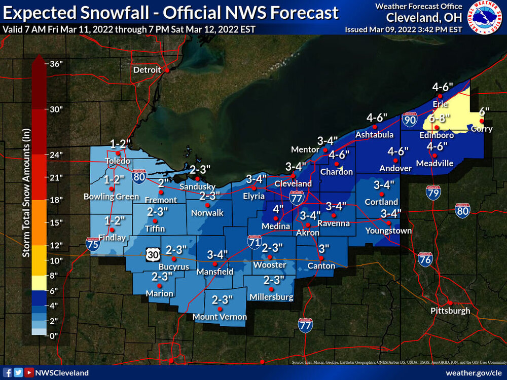
The synoptic snow is odd...a band of snow driven by mid-upper level lift well northwest of a deepening surface low will gradually slide across the area Friday evening through Saturday morning, with mainly light to moderate snow that can start turning heavier into Saturday. Current issues are that the trough looks positively tilted until Saturday morning and the low jumps quickly to the east coast. Because of that, most models keep the band of synoptic snow somewhat progressive and don't really rip the heavier rates until it exits to our east/northeast on Saturday. Some models, such as the Canadian, are a little less progressive and support over 6" of snow from Lorain and Mansfield points east. It wouldn't take a huge change on the other models to get that, but for now the forecast leaned on the more progressive camp which has much more model support.
There will likely be some lake enhancement to the synoptic snow starting late Friday night and continuing until it exits by midday Saturday with a NNW flow and 850mb temperatures cooling enough for lake enhancement. That may be a several hour window in which the higher terrain from Lorain and Medina Counties points east get a nice boost into Saturday morning. Pure lake effect takes over Saturday afternoon and evening...it's a mixed signal set-up with moderate to extreme instability and fairly high inversions, but a brisk NW flow and fairly dry air. My guess is most areas don't get a ton of additional accumulation from the lake effect, but given the instability if any upstream connections set-up they could have some intensity. It will get quite cold and windy into Saturday so there will be some blowing/drifting snow, it will feel like January instead of March.
My impression is that I mainly like our current snow grids (I'd hope so since I put them together), but I do have a sneaky feeling that the lake enhancement component pushes those hills south/southeast of the lake a little higher than our map...and we'll see if the true lake effect later Saturday into Saturday night adds much more or not. We'll see if there's any trend to a more amped system and more synoptic snow farther west, but we'd need to see that trend commence rather soon. At the moment my guess is we'll need advisories from roughly Lorain, Ashland, and Richland points east, with a lower chance for a few counties seeing warning amounts if the lake enhancement over-performs...or perhaps in some of our southeastern counties if the synoptic snow trends less progressive (which I kind of doubt).
-
1
-
-
Slightly over 3” of snow on top of a good 0.20” of ice here. Not quite how I thought we’d get there, but an interesting little event all around.
-
Left before the sun came up this morning, but some minor tree damage in and around the neighborhood as I came home and could see it this afternoon. Mainly just branches and a larger limb here and there, but a pine tree was uprooted near the entrance to the neighborhood. There were enough 0.25"+ reports and power outages / tree damage reports that it will likely verify as a marginal ice storm for roughly Wyandot, Marion, Crawford, Richland, Knox, Ashland, Wayne and Summit Counties. It's close for Medina, Portage, Trumbull, and Crawford PA though the 0.25" of icing may not have been quite widespread enough in those counties. NAM wins the prize on this one for sure. Strange, but certainly not boring winter.
Was pleasantly surprised to find about 2" of new snow here today when I got home, still snowing half decently.
-
4 minutes ago, Floydbuster said:
Dark and rainy here in Stow. No school closings yet.
We'll see about the schools. My side road was getting a little icy but they treated it. My driveway is a sheet. No snow or sleet accums here. Trees are bending but not breaking yet, estimate 0.15" of ice accretion here. But it's still 29 and pouring.
-
1
-
-
Freezing rain dominating this evening. The Marion-Mansfield-Medina-Summit-southern Geauga/northern Portage-Ashtabula/Trumbull area is getting a lot of precip as freezing rain. We will have tree issues in the morning when the wind picks up. Not thrilled that evening shift lowered the ice and went less than 0.10" almost everywhere but what can ya do I guess. This may be one of the worst ice storms in years in parts of that corridor and with little warning on true ice storm potential. Blegh
-
The NAM is a bit too warm, but this is definitely a junk storm. 1-3” of snow mixed with a bit of sleet and ice up here, with less snow south of Akron.


Northern Ohio Obs/Discussion Part 2
in Lakes/Ohio Valley
Posted
Parts of Lake and Geauga Counties got a bit more snow than we bargained for last evening into the overnight. Changing back to rain now, but would not be surprised to see a few inches in the higher terrain if people measure it early enough this morning. Some scattered power outages due to the wet snow on trees.