

OHweather
-
Posts
4,957 -
Joined
-
Last visited
Content Type
Profiles
Blogs
Forums
American Weather
Media Demo
Store
Gallery
Posts posted by OHweather
-
-
4 hours ago, NEOH said:
Woke to a coating of snow. Figured it would stay all rain but it changed over at some point.
Surprised CLE issued a lake effect snow warning in this area for 6-14” between now and Saturday. Maybe they just have to include the entire county. The heavy snow should be well north of here.
Unfortunately we are all of nothing for headlines in every county (except Ashtabula and Erie which have the lakeshore zones). Our current forecast supports a warning just because we have a solid 6-12” along and north of route 6. If we get reports from 3 separate locations that average out to 6”+ in a focused period of time (used to be a strict 12 hour rule) it’s considered an LES warning event. So for instance, if we get a report of 12” in Montville, 7” in Hambden 4” in Chardon it verifies as a warning event for Geauga. We had a discussion at shift change when I came in late in the afternoon yesterday and I was a no vote on adding Geauga to the watch. We'll see how it ends up verifying (even if the northern part of the county does get warning snow into tomorrow, including the whole county in a watch for the whole weekend felt like overkill).
That said, I do worry it focuses a bit farther northeast than our current forecast late tonight through early Saturday, which would leave pretty much all of Geauga and maybe even a decent chunk of Lake without much snow. This is a pristine LES setup, but the southern cutoff will be very sharp. Still looks good for stuff to shift farther inland by Sunday night or Monday.
-
 1
1
-
 1
1
-
-
Yeah, unfortunately we’ll watch the snow fly just to our north through most of the weekend. There could be an initial band that starts from the Cleveland metro into Geauga late tomorrow night into early Friday before it locks in closer to the lakeshore. While I think north east of us along I-90 will be the big winners, the environment is still pretty favorable for LES Sunday into the beginning of next week when we should get a more WNW wind direction. I’d say better than 50/50 odds we get a WNW flow band from Cuyahoga into Geauga at some point in there that drops warning criteria snow.
-
2
-
-
Measured about 2.3” here before I went to bed, already about half melted. A nice event for some with an interesting looking pattern starting next weekend.
-
1
-
-
What an overperformer in the Cleveland metro and east side!
-
1
-
-
It wouldn’t stun me if someone near Mayfield gets half a foot of snow in the next few hours with the band looking like it’s going to pivot there as the winds shift northwesterly.
-
Well I'd roll these dice if this pattern evolution is close to correct. It would be reasonably cold with snow opportunities for most of the sub-forum from late next week through probably the first 10-15 days of December. The pattern looks panhandle hook/cutter-ish initially the end of November and looks more clipper-ish by a week into December.
-
6
-
 1
1
-
 1
1
-
-
On 11/19/2024 at 9:34 AM, buckeye said:
Have you done a winter forecast yet?
I've been gradually working on it. Hopefully can get something posted later this weekend or next week. We'll have some chances around here, but I don't expect a wall-to-wall great winter. Probably will be a couple decent cold windows with snow chances with a couple of prolonged mild spells as well.
-
1
-
1
-
-
2 hours ago, NEOH said:
First snow of the season... and its sticking surprisingly with the warm ground. Shoutout to OHWeather for the "bonus extra long term"

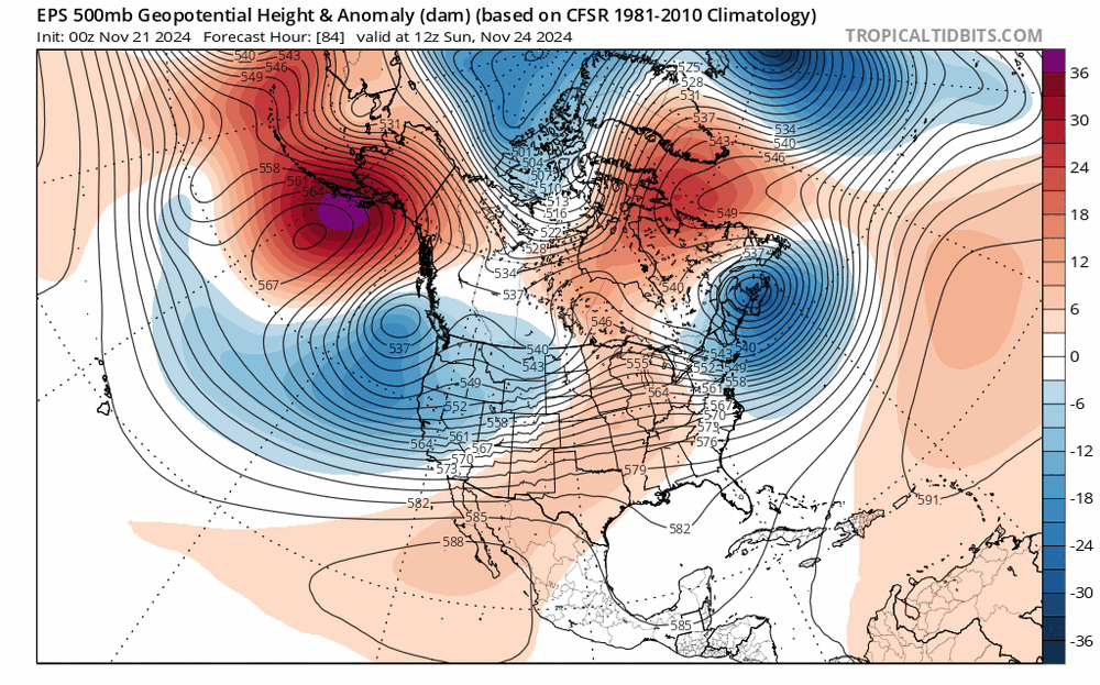
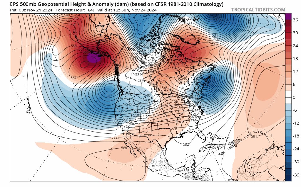
Some bonus "extra long term" this morning...global model ensembles are in good agreement that a robust "blocking" ridge in the jet
stream over the northern Pacific near/over Alaska will be persistent this week and likely through roughly the first week of December.
This pattern will significantly increase Arctic influence into North America, much more so than we`ve seen so far this fall. There`s
relatively strong agreement that a chunk of this air will attempt to dip into the U.S. to end next week, with potential for cyclogenesis
over the central or eastern U.S. around the end of next week ahead of the blast of colder air. Regardless of where any low pressure
develops and tracks, colder air will likely spill in behind it next weekend, with GFS and European ensembles both depicting roughly 50-
50 chances of 850mb temperatures dipping below -10C over the local area next weekend with much higher confidence just to our north and
northwest. This colder pattern likely then sticks with us through at least the first week of December, illustrated by the current CPC 8
to 14 day outlook depicting fairly high-confidence in colder than average temperatures for the period beginning the end of next week,
with a slight tilt towards above-average precipitation in that period too. While it`s too early to know for sure how effectively
cold air will work into the local area and if we`ll see a more widespread snow, potential for at least some lake effect snow in the
snowbelt and colder weather for all seems evident if this pattern plays out as ensembles currently depict starting next weekend.
Passing the time at 4 AM is an art
")
The lake effect that pushes into the metro area and east side late this afternoon into this evening will probably be intense, and it should be cold enough for it to snow and accumulate away from the immediate lakeshore (it'll likely snow down to the lakeshore but may not stick). It'll probably push through the area within like a 6-8 hour span, but if a band can hang over any particular spots for a length of time a quick few inches is possible. Most will see less, but I will take this potential all things considered
-
3
-
-
6 hours ago, nwohweather said:
@OHweather How long did it take to write that AFD?
Felt like it was back to the days of your blog with that prose you had going there
About an hour and 15 mins lol. The crazy solutions have backed off, but it's looking like there should be snow flying Thursday into Thursday night as moisture wraps back in from the north/northwest. Maybe parts of Ohio can see a light accumulation. It's nice to have a little bit of snow to look at, even if there's still nothing extremely exciting on the horizon.
-
3
-
-
Nothing too exciting on the horizon, but most of Ohio should see at least a few flakes in the air Thursday into early Friday and a few spots may see a light/slushy accumulation. Just enough to remind us that we're deep into November already.
-
5 hours ago, NEOH said:
12z Euro took a big step toward the GFS.
Indeed. The 0z NAM and Euro are looking like fun fantasy runs. We should still see some flakes in the air Thursday into Thursday night.
-
Still quite a bit of uncertainty, but with the 0z Euro and NAM spitting out very strong solutions for Wednesday night into Thursday with both models suggesting potential for accumulating wet snow and strong winds only 72-84 hours out, I think it's fair to say that later this week is finally somewhat interesting around here. Even at a bare minimum, the GFS solution would suggest wind-blown flakes flying Thursday around here.
-
1
-
-
Saw some token small hail and graupel with some of the lake effect showers on Tuesday. It’s almost that time of year…
-
On 8/9/2024 at 11:20 AM, LakeEffectOH said:
I was hit by that tornado. I took out 8 trees on my property...fortunately, none of them fell on my house. Still without power...ugh!
During the storm, when I was at work in Solon, I saw a red elliptical area, over NW Geauga county in an otherwise sea of green on doppler radar. My radar was set to storm relative velocity, tilt 1. It looked so weird.
Hopefully your power is back on by now! Sorry to hear about the mess on your property but it's good nothing hit your house.
That red elliptical area were winds blowing east with the gust front. The storm was pretty complex...there were east-southeast winds ahead of the squall line (which appeared as inbounds on the radar), a small area of west-northwest winds with the gust front (the red outbounds on velocity), and then a strong surge of northerly winds with a rear inflow jet behind the squall line (which showed up as green inbounds on velocity on the CLE radar). There also was a book-end vortex that came onshore just northeast of downtown Cleveland and tracked roughly east into southern Lake/northern Geauga, which augmented that rear inflow jet. The very strong straight line winds that impacted much of NE Cuyahoga, western Lake, and northwestern Geauga happened as the rear inflow jet wrapped in behind the bookend vortex and the tornado in Chesterland happened in association with that mesovortex.
20 hours ago, Floydbuster said:I cannot believe this was such a historic event for NE Ohio. Governor DeWine has declared a state of emergency for the affected counties.
What the heck made this so historically intense as a system? It was literally just a front and thunderstorms. Good grief.
I think what made this one so impactful was the area hit. Out of the 4 tornadoes, two of them had rather long tracks through very populated areas in the heart of suburban Cleveland. Outside of the tornadoes, there were widespread 60-70 MPH winds from Lorain County into the Cleveland area which caused scattered tree/power-line damage outside the tornado tracks. Into the east side gusts increased to 70-90 MPH, locally up to 100 MPH in northeast Cuyahoga, western Lake, and northwestern Geauga. We actually surveyed that extensive area and only found the one tornado track in Chesterland, along with widespread, significant tree damage caused by straight-line winds. That hit a fairly densely populated area in the eastern suburbs. From there, there was scattered tree damage well to the south and southwest of Cleveland including Medina, Youngstown and the Akron/Canton area which added some impact to the power grid...and the rest of northeast Ohio (Ashtabula, Portage, Trumbull and Mahoning) had scattered downed trees with pockets of more intense damage...the bow echo (and associated bookend vortex and rear inflow jet) continued across southern and eastern Geauga, northern and eastern Portage, southern Ashtabula and northern Trumbull and there were more localized pockets of significant tree damage (not quite to the level of the east side of Cleveland but there were probably pockets of 80 MPH wind all the way across to the PA border embedded within widespread 60+ MPH gusts).
That added up to a relatively localized but significant impact in a very densely populated area surrounded by a large area of less significant damage which added to the power outages. I think last August's derecho and tornadoes (August 24th-25th overnight) would have been more substantial if it hit in the afternoon or evening and not at midnight. The tornadoes with that event were more significant than with this event and the rear inflow jet aloft on radar was larger and stronger. However (and fortunately), the straight-line winds didn't mix down as effectively at midnight when that came through last August...the damage ended up being significant but streaky and relatively scattered with little damage in between. At peak heating, the straight-line gusts with that even would have been much more widespread and perhaps slightly more significant on the top end, so I think the tree damage and power outages would've been more significant that this most recent event. The June 2022 derecho, which crushed portions of north central and east central Ohio, produced a nasty swath of 60-80+ MPH type winds starting in northern IN and northwest OH with pockets of 100-120 MPH in parts of southern Wayne, Holmes, and Tuscarawas Counties. That would have been worse than this if it hit the Cleveland area. Even the November 2017 macroburst (which was associated with a similar bookend vortex and rear inflow jet as this event) across the Cleveland southern suburbs may have rivaled this event's power outage numbers if it occurred more directly over the Cleveland area and happened when leaves were still on the threes.
So my impression is that I'm relatively impressed by this event and it certainly had a high impact, but we've narrowly avoided worse outcomes in the metro area for one reason or another in recent years. So while it is "historic" by a power outage perspective for the Illuminating Company, I do not think it's anywhere near unprecedented for what storms can do in the northern half of Ohio.
What allowed this system to produce higher end severe was a combination of a seasonally strong front and wave of low pressure riding along it, which added lift and enhanced low-level shear, a very moist airmass which allowed for good instability to develop, even slightly north of the front in stronger shear, an incoming shortwave which added large-scale lift and supported quick upscale growth of thunderstorms, and fairly strong winds aloft which provided enough shear for organized/rotating updrafts and mesovortex development within squall lines, which supports stronger bow echoes and QLCS (squall line) tornadoes. It was actually quite a favorable set-up for northern Ohio standards.
-
2
-
1
-
-
There was a small embedded tornado track from far southern Lake County into the northern portion of Chesterland, but otherwise it seems like most of the damage from the east side into Lake and Geauga was due to a very strong rear inflow jet punching into the bowing line of storms.
-
2
-
-
That was certainly the event of the year around here. More than half of Lake and Geauga are still without power, and the outages have barely come down since last evening.
-
More than half of Lake and Geauga Counties are still without power in NE Ohio, with outage numbers barely budging in Cuyahoga County since last evening (down slightly to a bit over 200k outages/38% out in the county). Impressive event with what will likely be a handful of confirmed tornadoes and widespread straight-line wind damage.
-
19 hours ago, nwohweather said:
Thanks for providing this synopsis. Seeing the thermals initially at the surface the environment seemed absolutely primed, but I was not thrilled at the mid levels. Interesting it was less lake influence and more warming in the mid levels.
I do think that if a tornadic supercell played out over NW OH that the lake influence may have still had in effect on it as it approached the lake, though in this case I think other factors just prevented a tornadic supercell altogether.
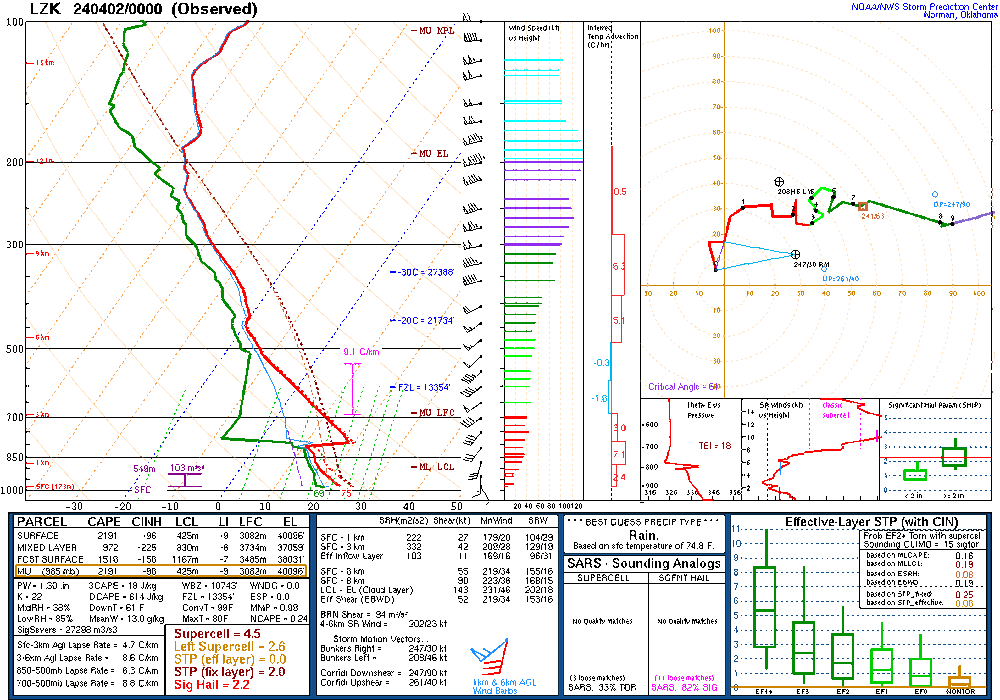
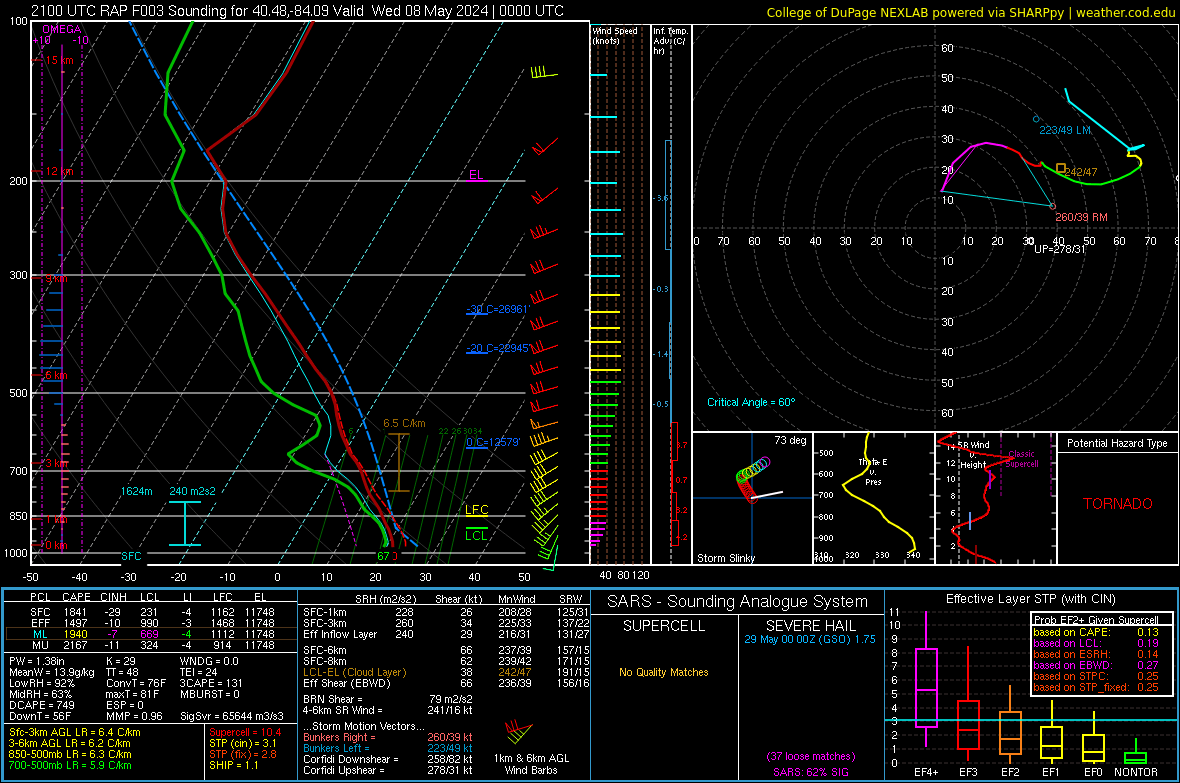
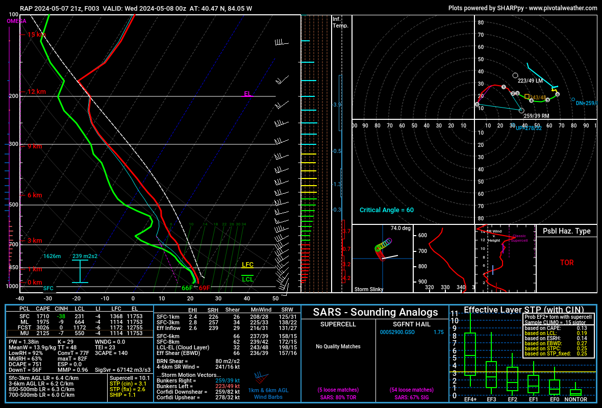
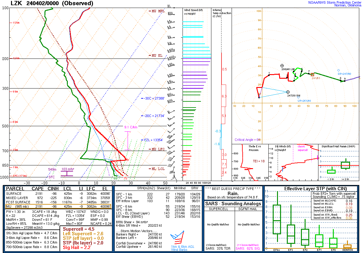
13 hours ago, frostfern said:I've observed that outside of the deep south and plains, tornadoes sometimes favor the margins of the highest CAPE. There was a super sharp CAPE gradient over far SW Michigan. The later batch of convection was associated with the leading edge of even higher CAPE with dewpoints near 70 pushing into the OV later in the evening. This effect I've observed might just be a side effect of the wind being more backed in the lowest km near warm fronts or other types of horizontal temperature gradients. The Michigan storms also seemed lower topped due to being closer to the upper low. CAPE was possibly fatter despite being less overall. The storms were also more strongly forced under an area of vorticity advection aloft as opposed to being driven by afternoon heating.
Fully agree with this. I do think that as you suggested, the CAPE gradient suggests some sort of boundary (often a front or outflow, sometimes differential heating) with winds often more backed along and on the cool side of boundaries...with boundaries also providing for low-level convergence/lift which can aid in getting stronger updrafts. Whatever the reason(s), I've heard the words "it's always on the gradient" uttered more than a few times in operational meteorological settings. Also agree that the storms in Michigan on Tuesday benefited from stronger forcing, and per this RAP sounding (likely not perfect but hopefully close) low-mid level lapse rates were steeper than the NW OH sounding. Can also note some very large hail analogs on the bottom right, with a higher % of the loose matches being significant than in the NW OH sounding. Surface winds along and on the cool side of the warm front were SE, which would increase SRH from what this sounding shows:
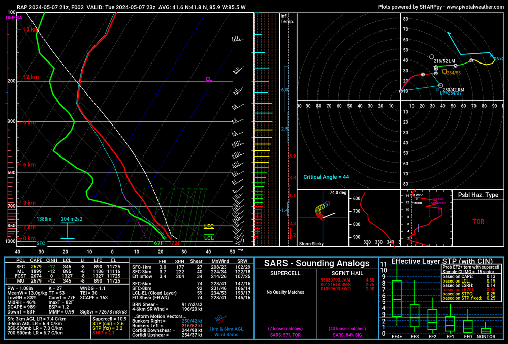
-
11 hours ago, largetornado said:
Rap sounding from northwest Ohio. What prevented a mode significant tornado?
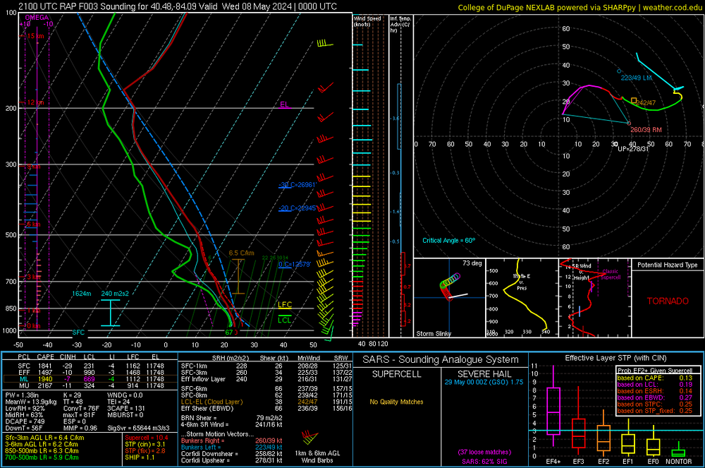
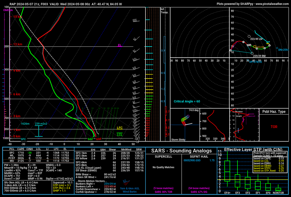
On that sounding the two main negatives that stand out to me are the poor low to mid-level lapse rates leading to a tall/skinny CAPE profile along with weak storm relative winds and a messy hodograph in the 2-4km layer. Here's essentially the same sounding from Pivotal with height in km placed on the hodograph, helps visualize the lack of shear in the 2-3km layer (2 and 3km are almost on top of each other):
I'm guessing that between the skinny low-mid level CAPE profile and relatively weak storm relative winds in the mid-levels there might have been more of a struggle to maintain strong/deep updrafts around NW OH than you'd otherwise expect with over 1500 J/KG of MLCAPE, 60+ knots of effective shear and 200-300 m2/s2 of effective SRH. You can sometimes get more severe wx out of a lesser amount of CAPE that's all focused below 400mb with a thicker CAPE profile than with a greater amount of CAPE but with a skinner CAPE profile through a deeper layer.
The other thing that stood out to me in northwest / north central OH was just where storms initially developed. The storms that initially developed from east-central IL into central IN ended up being the main show in the northern OH Valley and fired on the nose of the deeper instability advecting in from the southwest. The mid-level flow was southwesterly, so these storms developed upstream of northwest OH. I am guessing that as these storms grew upscale that some subsidence and warming in the mid-levels occurred. I think that's why the cell that went tornado warned east of Fort Wayne into Northwest OH did OK for a bit but then started weakening as activity to the south/southwest continued to grow upscale. It's possible this led to warmer mid-levels and an even worse CAPE profile over NW OH in the evening than the RAP sounding suggested. The cells that developed over NE IL/far NW IN and tracked into MI were beneath the divergent left-exit quadrant of a jet streak rounding the base of a negatively tilted trough so had the benefit of stronger forcing and were more separated form the Ohio Valley storms. And as we all know those storms certainly produced.
It's been a frustrating spring for convective forecasting in the northern 1/3 to 1/2 of OH. Every setup has had shear but most setups, outside of March 14th, have had relatively marginal thermodynamics. If you get sustained deep convection you'll get tornadoes in these set ups given the shear, but if you don't get that because there's just not quite enough instability everyone thinks we're nuts for predicting a risk of tornadoes. March 14th and April 17th produced (though March 14th had great thermos, the main uncertainty was how far northeast the instability would get behind earlier day rain). A few other of these high shear, marginal instability setups (April 2nd, April 11th, yesterday) did not produce locally.
-
4
-
2
-
-
Was sweating the cirrus here in Cleveland but it was thin enough that you could see through them enough to see all the cool stuff. Had the 360 degree sunset effect on the horizons with the cirrus adding some color. Briefly saw a couple of planets. Bats came out, streetlights came on. It was about as dark as it is immediately when the sun sets I would say. Seeing the corona and some solar flares was awesome. The difference in the amount of light between a 99% eclipse and totality was impressive. As soon as even the smallest bit of the sun came out from behind the moon the light noticeably increased. Overall I'd say it exceeded my expectations.
-
4
-
-
A few comments on this event, focused on the Ohio Valley...
1. An enhanced risk (for winds and possibly tornadoes too, pending surveys) was warranted across the Ohio Valley. From a verification stand point I do not think the Moderate Risk panned out anywhere (especially for tornadoes). The northern extent of the threat was significantly less than outlooked.
2. The main reasons this busted were due to repeated rounds of convection that were ongoing both along and north of the warm front and in parts of the warm sector from last night through all of today. This chewed up the EML and limited destabilization farther north and east. You can tell that convection that tried firing along the cold front and a pre-frontal trough in the late afternoon and early evening was struggling due to limited spacing between it and pre-frontal convection that was already ongoing. The storm mode was also messy, probably because junk developed quickly in the warm sector and it was impossible to come back from that.
3. I was concerned about some of the uncertainty and was surprised to see the Day 2 moderate (at least as far north/east as it was). I felt the 12z HRRR and NAM on Monday did depict outbreak scenarios and that the outlook needed to ramp up from the morning outlook on Monday...but there were enough CAMs with less exciting solutions for multiple reasons that the moderate risk was certainly an aggressive forecast. However, I thought something significant still had a decent chance to play out somewhere (likely in the Ohio Valley). With such a large warm sector, deepening low pressure and insane wind fields, it felt like it would be hard to avoid somewhere destabilizing and having a supercell or two take advantage of that locally more favorable environment. It's possible there were a couple of strong tornadoes today and there were probably more than a few weak tornadoes, including with the morning QLCS into WV. However, I would say I definitely expected more to happen even if certain parts of the threat/outlook didn't sit great with me.
4. The Tennessee Valley generally busted too, due to junky convection firing too early in the warm sector down there. This whole event was cursed apparently.
5. Given a fairly legitimate potential for a significant tornado or two somewhere this threat certainly required stronger than normal messaging. However, I feel like the way severe weather outlooks are often presented does not always do a good job of advertising uncertainty or bust potential. It's just "strong to severe storms possible between 3 and 8 PM, here's the outlook showing a slight risk". While I saw a couple of people in OH on Monday mention potential for ongoing clouds/rain earlier in the day to mess with the threat that generally was not mentioned until today when it was in fact raining. Instead, the messaging was focused on what is pretty much an unprecedented severe weather outlook, a Day 2 moderate risk driven by tornadoes. That was messaged as a very rare outlook for Ohio (which is not incorrect) and took on a life of its own. The event couldn't bust without meteorologists looking bad, so of course it busted for most of OH.
Overall, severe weather risks that have a ceiling of a regional tornado outbreak but legitimate bust potential are a challenge to message and there's room to get better at it.
-
4
-
2
-
-
The stuff currently developing from central IN into KY (and anything that fires immediately ahead of it) will be “the show”. We’ll see what the show ends up being. Airmass recovery attempting to occur ahead of that activity but it’s a short window to do it. The low is deepening so wind fields will be extremely robust. We’ll find out quite a bit about if much will happen in the next few hours.
-
1
-
-
0z HREF probability for STP >3 and member updraft helicity (supercell) tracks. Mod-high probabilities for STP >3 from central OH-IN through parts of KY & TN surrounded by lower probabilities, with sct'd individual member supercell tracks. The setup has a high ceiling, but:
.thumb.gif.cc810b8395d8b7edffa175d624be5834.gif)
Neighborhood probabilities for supercell tracks are moderately high in the Ohio Valley (best environment), high in the Tennessee Valley (slightly lower STP >3 probs), and low-moderate north into IN/OH/W PA (lower confidence in STP >3 farther north). There is uncertainty:
.thumb.gif.c2763d2a53abede04b292d7fcae07f8a.gif)
For instance, the 0z HRRR has extensive elevated convection in the Ohio Valley that continues through midday, with warm sector convection becoming widespread by 18z. This would be some sort of (potentially more middling, though with conditional risk for strong tornadoes still) OH/TN Valley tornado threat but with more limited northward extent into IN/OH.

On the other hand the NAM clears the morning Ohio Valley convection slightly quicker and also delays warm sector initiation longer into the afternoon. This would lead to a likely more significant tornado threat in the Ohio Valley that extends into much more of Ohio.
.thumb.gif.353da14bbc670485f4234660324d3767.gif)
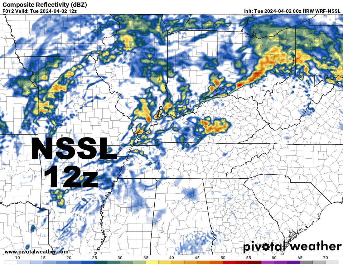
The NSSL WRF is a bit in between. It clears the Ohio Valley morning convection a bit quicker but also has a fairly busy warm sector by mid-afternoon. Verbatim it still would be a somewhat messy Ohio/Tennessee Valley evolution but there would be a tornado risk, especially in the Ohio Valley where there could still be a conditional significant tornado risk with this sort of evolution. In terms of northern extent, there'd be at least some threat for most of Ohio along and south of the warm front.
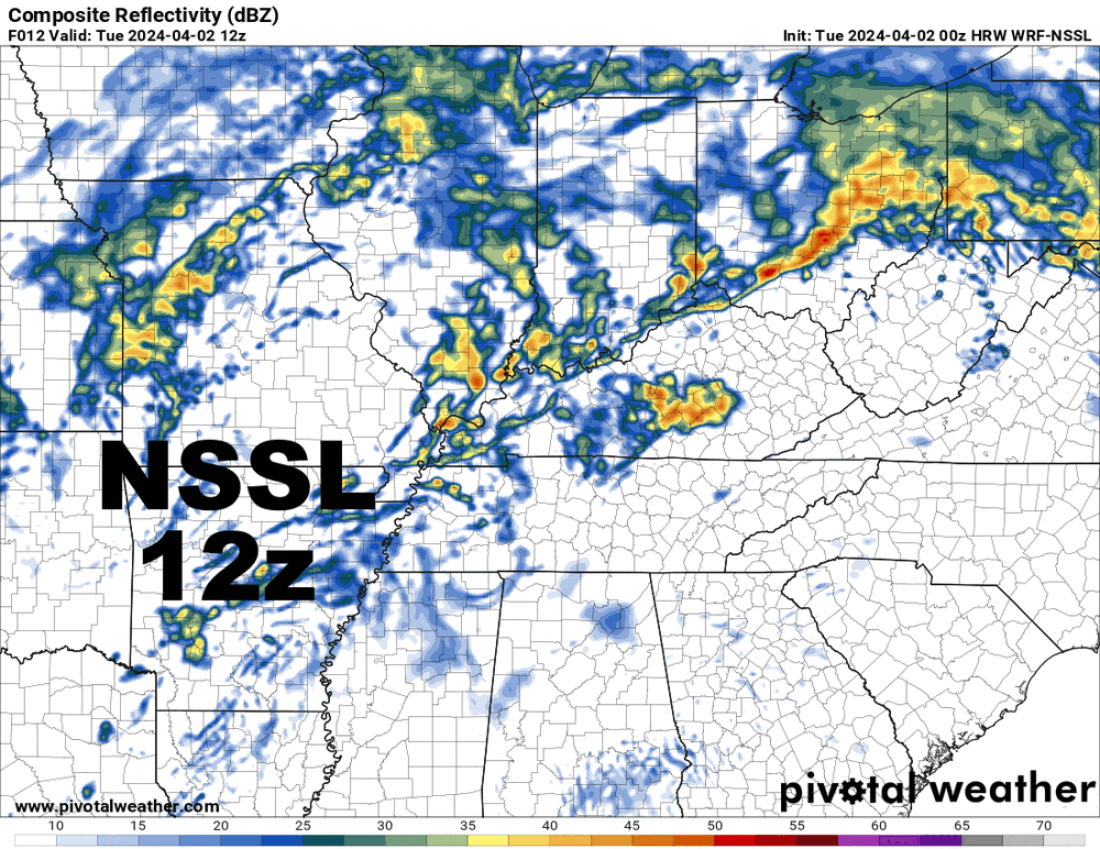
And finally, the ARW with similarities to the NSSL, clearing the morning convection fairly early and developing warm sector convection a bit quickly (tho not as fast as the HRRR), with a middle ground solution in terms of overall tornado risk and northward extent into OH:
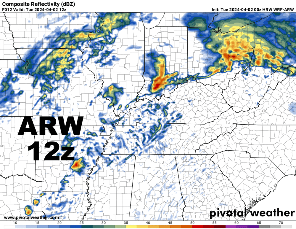
Some subtle adjustments can probably already be justified for the initial day 1 outlook at 2 AM eastern...however, I doubt there will be anything wholesale until later in the morning when it's much more obvious how the ongoing convection is behaving. 3z HRRR would probably play out somewhat close to the 0z NSSL WRF if it ran out further...
-
1
-
-
9 minutes ago, largetornado said:
At this point, will the EML in Arkansas/Southern MO/TN be eroded by that ongoing convection or will it inhibit it?
I'd lean more towards the convection eroding the EML than the other way around.


.gif.ba033bc476ed1dcf7f29e860bd6daa0c.gif)
.gif.9e11d0dfddb0cdc4e6e499b5bcfe6834.gif)
.gif.32ccbf095e9d9775f131a83bde4a876d.gif)

Northern Ohio Obs/Discussion Part 2
in Lakes/Ohio Valley
Posted
I full expect someone to have 3 or more feet by Saturday out that way, but I kind of think the band focuses a bit farther north than that, from far northern Ashtabula into Erie County. It’s a nutty setup and the model outputs are about as robust as I can remember around here.