

OHweather
-
Posts
4,889 -
Joined
-
Last visited
Content Type
Profiles
Blogs
Forums
American Weather
Media Demo
Store
Gallery
Posts posted by OHweather
-
-
Congrats on the snow up there, it hit a day late lol. There's a Huron band that looks poised to move into Lorain and Cuyahoga Counties in an hour or two, we'll see how much moisture it can pick up off the lake.
-
About 3.5" here. Hit the high end of the forecasts nicely. Roads were really bad in the wee hours this morning when I got home, probably could've used an advisory due to the combo of 2-4" of snow, temps in the 10's and a good amount of blowing snow. Over 350 schools closed again today.
-
Any know how CLE's snowfall map is generated? Another over done map.
I'm pretty sure those maps come straight from their grids added up, but not 100% sure. There may be a little bit of human input on the map itself (obviously their grids have human input).
I didn't want to post that map this morning because I really don't agree with it. It's a good LES setup for SW NY south of Buffalo and that could come into Ashtabula and Erie at times, maybe Lake County can get grazed and get a couple inches of LES on top of the clipper. But with a mainly WSW flow and ice cover expanding on the lake I'm not very optimisitc for NE Ohio on this one.
The clipper tonight could cause a mess due to temps only in the 10-15 degree range, more high ratio snows and gusty winds...with wind chills probably falling below -10F again tomorrow at some point. A lot of kids may get another day off tomorrow.
-
I'd say that I'm not really surprised at today's bust. The wind today was so relentless that it looks like there's actually less snow on the ground than yesterday, before the inch of fluff fell overnight.
While not gospel, the hi-res models are pretty good indicators. If none of them are showing any major accumulations, then one shouldn't expect a broad brush of 4-8" and 6-10" that was forecasted. I think the signs had started developing 36 hours prior that this wasn't going to be a big event, but after a week of things looking good, it's hard to back down from that kind of forecast. Perhaps, had last night's band been slower, sitting over areas for 2-3 hours, instead of 20-30 minutes, then accumulations might have just barely hit the low end of the forecast.
The best snow producers for CLE are the old fashioned enhancement events, where wave after wave of snow rotates in off Erie. I think the last classic event was back at the end of February 2010.
As for this season, I think our best of winter already peaked in mid November. It will probably be hard to top that week for the second half of winter.
The bust wasn't shocking IMO, but it still doesn't make it nicer.
I was pretty confident in the event coming to a halt pretty quickly when the winds went NW, but over-estimated the morning band by a fair bit so I was still decently too high for most places. Very cold but dry NW flow events bust often, but W-E bands ahead of a surface wind shift often do better. It may be a combination of the ice that formed and the sharp wind shift causing the band to move quickly once it developed that caused that portion of the event to do relatively pourly too. Really, nothing good happened with this event. It snowed half decently out here this evening, but the flake size was very small so we maybe got half an inch, pushing the storm total up to about 2".
In general, I agree with your assessment of the hi-res models. My one big issue with them is no models will consistently pick up on W-E bands that can dump heavy snow on Cleveland or parts of Cuyahoga County...sometimes they'll see it, sometimes they won't. So that's tricky, although with a more "straight forward" NW flow setup they'll usually give you a better idea.
We had two really good enhancement events in the 2009-2010 winter...one at the start of January that droped over 3 feet of snow on Solon over a few days, which started as a more traditional WNW flow lake effect event but had Atlantic moisture wrap in around a stalled storm to our east...and the one at the end of February you mentioned. It would be nice to see one of those again this decade.
The clipper looks better for Thursday night...decent model agreement on 0.1 to 0.25" of QPF, and BUFKIT profiles for the NAM show the strongest lift in the DGZ for a time, so ratios could be pretty high. 2-4" seems possible. Lake effect could be decent in northern Ashtabula County into NW PA and SW NY Friday-Saturday, but doesn't really look to affect the Cleveland metro.
After another potential near 0 or sub-zero night Friday night, we'd need a decent warm up with lots of rain and wind to see decent lake effect the rest of the winter, unless we get a freak April event or something after the lake thaws...so it's disapointing to see the LES season come to an end like this. There's still a ton of time for synoptic snows, even if the models look iffy at best for the next week or two in that department. I was optimistic for CLE coming in above average in the snow department heading into the winter, but they'll likely be running a modest deficit still or perhaps be near normal after the dust settles by the weekend. If we see very little over the next 10-14 days that will turn into a decent deficit, and we'd need synoptic snows to get out of that hole unless we magically get a torch to thaw the lake, so it'll be tough at this point. Although still plenty of oppertunity for "fun" left, as it is just early January right now.
-
Lake effect snow should never have been expected with the polar vortex in Ohio last year, the wind was SW at all levels of the atmosphere and the central and western basins were essentially frozen, so why CLE and local news stations proclaimed a lake effect blizzard with that is still beyond me. Buffalo got a nice event out of it but strong convergence on that end of the lake can help maximize things when other parameters are marginal...more so than in NE Ohio.Like last year when the Legendary Polar Vortex
 (per media hype) with its subzero cold was accompanied by very little LES. Even lake effect cloudiness was limited.
 -
What a dud of an event. Air is just too dry...that's the problem with these really cold air masses as they come with really dry air that all but wipes out the LES. It's better to have a moderately cold air mass as more moisture is available for the LES bands to develop...an unfrozen lake also helps too.

Bingo. Totally agree with that. It's too bad this airmass was so dry because it's freezing the lake.
-
Yeah, definitely looks like some Lake Michigan moisture enhancing things west and south of town like we were a bit worried about yesterday. Hopefully that Huron band can dump on Maidesnow in NW PA
-
Any possibility the bands quit moving around so much, or are the winds shifting too much?
There's a clipper for tomorrow night also isn't there?
The winds and hence any bands might stabilize for a few hours this afternoon. Where the bands stabilize, if the do, I guess there could be a couple of inches more today.
The clipper will bring snow, maybe an inch, with more LES for Lake and Ashtabula into NW PA. So I guess on the bright side we won't be melting all of this snow anytime soon and should have a half decent snow pack.
-
We've had a few good bursts in Chagrin. Flake size was ok as well. The bands are migrating instead of staying in one place. To see the higher totals we'll need a band to lock on place. Considering the fetch I don't think that ice is the limiting factor. Once the fetch turns more westerly I do think the ice will play more of a role.
Yeah, no ice bothering us right now, but I do think that played a big roll this morning when the winds were more west. I'm surprised how much of the lake froze so quickly. Ice from Toledo to Lorain really kills the fetch of open water for Cleveland...although we have seen better evens with more ice so idk.
At least the Euro shows something 7-8 days out
-
Pretty good snow under this band despite fairly light returns. Unfortunately it's moving. We'll see if a consistent light to at times moderate snow can at least set up in the orographic lift areas inland and allow it to stay wintry looking today, even if amounts end up being light.
-
NW flow events with dry arctic air always seem to produce over aggressive forecasts with the best frequency out of any type of event. I think most of Cuyahoga will struggle to hit my 3-4" low end at this point. Short fetch plus dry air is a bad recipe, and I do wonder if the ice that developed limited the band this morning, or if it just moved too quick or what. Anyways, outside of the Huron connection I'm expecting maybe another inch here or there today and another inch or three tonight at this point. Just not enough moisture.The Lake Huron connection band should prove to be quite impressive. It'll be interesting to see what kind of totals come out of it.
For the rest of northern Ohio, I still think storm totals are way too aggressive. Lorain County is under an advisory for 4-8", unless a significant band develops there, that's going to bust hard. The snow maps out of CLE are showing 12"+ amounts in the eastern suburbs of Cuyahoga, I find it very hard to believe the 271 corridor is getting 10" today. Perhaps we'll be surprised, but I just haven't liked the way this was setting up since yesterday.
The CLE snow map above runs through Friday evening, so you can take some out to get this event's forecast. Even so amounts may end up too high by a good bit.
Edit: the one NEOH just posted is just for this event.
-
That band disappointed this morning. Somewhere between 1-2" here, and am not expecting much more. Maybe another inch or so later at some point.
-
Great to hear! Snow starting to increase now across Cleveland...worst timing for the commute here.Dumping pretty well out there at the moment and has for several hours. Measured 6" exactly thus far. Keep on bringing it!
-
I'm confident in a decent band into Lake/Ashtabula into NW PA tonight dropping 4-8" type amounts, with a nice squall dropping 2-4" on a short period as the front causes that band to pivot south during the early morning tomorrow. After that though I'm definitely worried about a period of very disorganized snow in the Cleveland metro before an increase in the evening. I think the band tonight into early tomorrow will be intense enough to get a lot of areas close to my low end totals, with any bands that can redevelop during the evening adding to that.
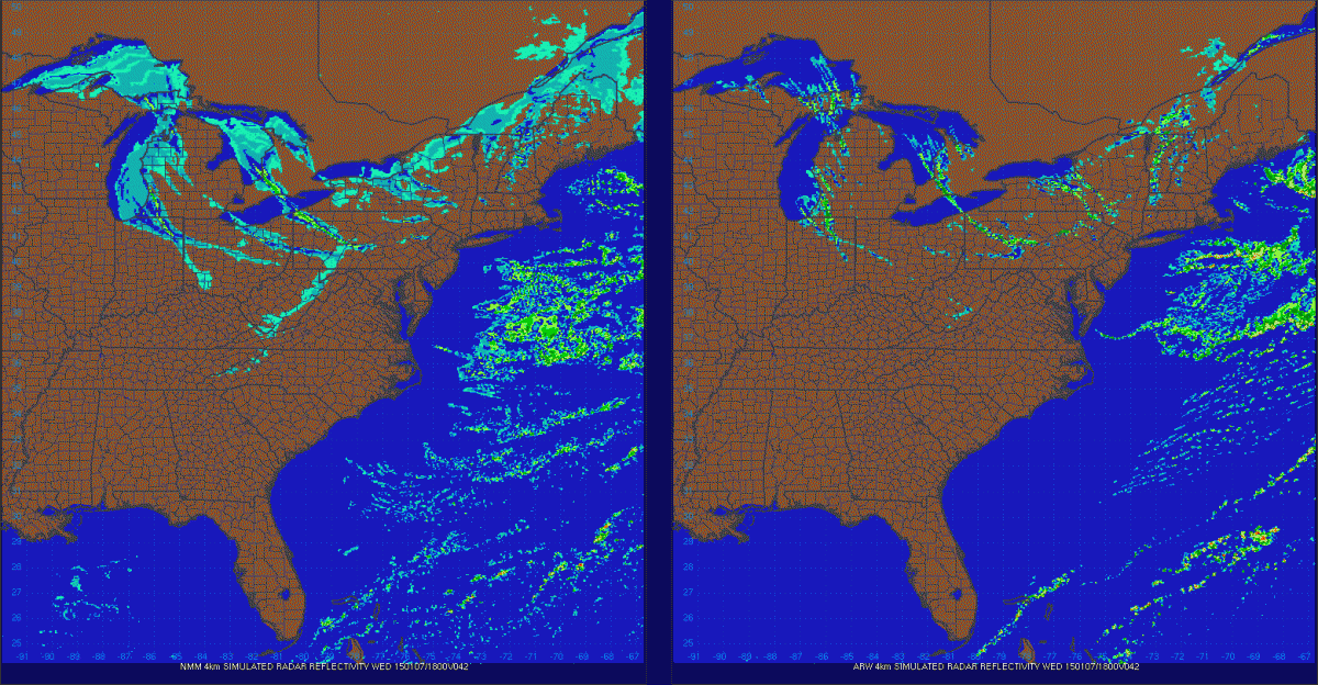
The ARW is stingy and shows .1-.2" of liquid across the metro and a little more in parts of the Snowbelt... The NMM looks like a decent quarter to half inch in the traditional Snowbelt with close to 0.75" in Lake County. So we'll see how it plays out
-
Yikes at that ice! There are still probably some holes so there will probably still be some heat/moisture flux from the western basin, but it won't be as strong. There's still a decent band hugging the Lake County shoreline and the instability isn't even that good right now, so I think we'll still be ok later. It'll be windy so the central basin can only freeze up so fast.
I agree that CLE is a little aggressive with their amounts. Their advisory reads 4-6" with locally more, which I generally agree with for those counties, although their grids have a lot more as shown by the map posted above. It looks like they have a good amount of snow tonight across Lorain/Cuyahga/Geauga when the winds will be SW and causing any snow to hug the eastern lakeshore which adds probably 3" to those areas.
With the dry air working in tomorrow, this strikes me as an event where the bulk of the snow falls in two bursts...one early tomorrow as the front drops south and another tomorrow evening as the winds become more WNW again. So there could be a lot of downtime late tomorrow morning and afternoon where it's just cold/windy with flurries.
Looks like about 1.5" here from the clipper, and 2" on the ground.
-
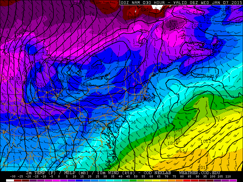
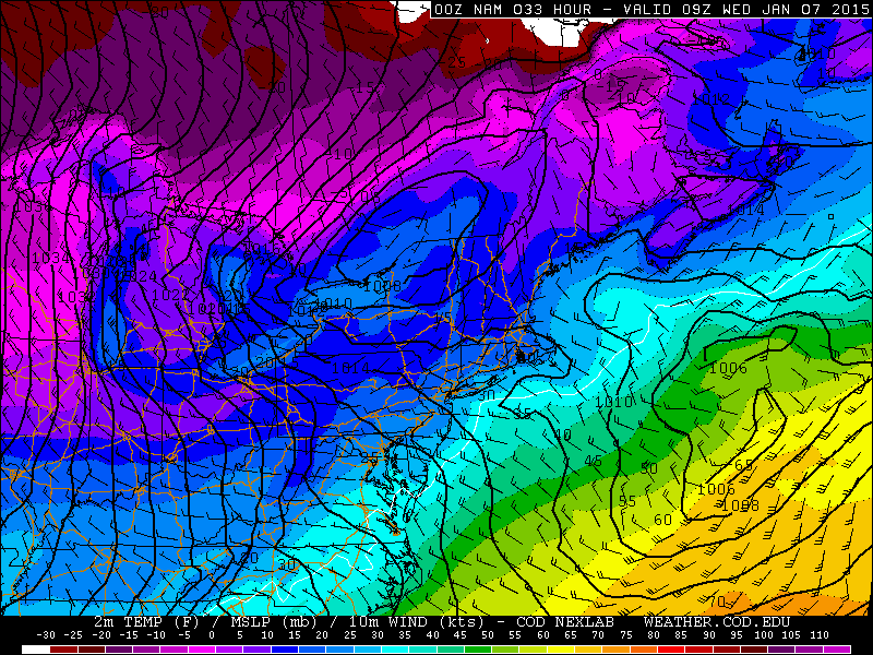
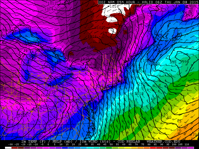
A deep upper level trough will move across the Great Lakes Tuesday into Wednesday and allow very cold air to spill into Ohio. An arctic front will drop south across Lake Erie and northern Ohio between 2AM and 8AM Wednesday, with a northwest flow setting up behind it. Ahead of the front, a strong band will likely form along the eastern lakeshore and then swing south with the front. Behind the front, questions about drier air and a short fetch due to a NW flow make the forecast tough, despite extreme lake induced instability and very high inversions.
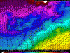
Ahead of the front, the hi-res models suggest strong convergence along the Lake Erie shoreline, with the winds trying to back to the SW over land while they become west and eventually WNW over Lake Erie. This seems like good support for a decent single band to form along the eastern lakeshore, and the NMM and ARW both show this by 1AM Wednesday:

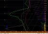
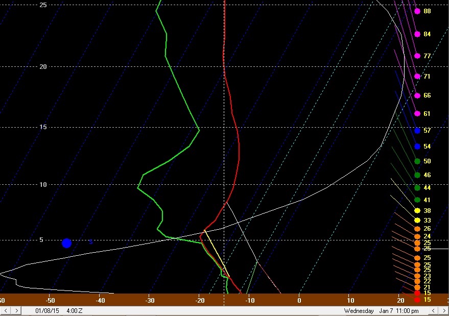
BUFKIT forecast soundings by this point indicate moderate lake induced CAPE with equilibrium levels near 8k feet and rising, with moisture depth to 6-7k feet. These parameters are all marginal to good, and with such strong convergence evident on the mesoscale models along the eastern lakeshore I’d expect a band with moderate to heavy snow to be developing quickly by this point if it doesn’t develop even a few hours sooner:
The surface winds have a good southerly component, however with decent WNW winds in the boundary layer mixing to the surface over the lake, I’d imagine the band would be a few or several miles inland across Lake and Ashtabula Counties. There is good moisture and instability in the DGZ, so I’d expect very high snow ratios on the order of 20-30:1 in any band in this timeframe, so snow rates of 1-2” per hour seem like a good bet under any banding in Lake and northern Ashtabula Counties between midnight and 4AM Wednesday.
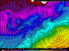
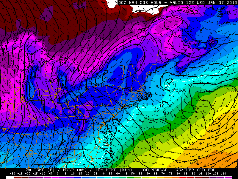
By 4AM Wednesday, the front is approaching the lakeshore but still hasn’t pushed inland yet per the 0z NAM, GFS and Euro, so I’d expect any band to still be close to the lakeshore…although it may begin budging south. Also, note the decent convergence as far west as Toledo, suggest a burst of snow could occur across all of northern Ohio as this front drops south just before dawn on Wednesday. The convergence across Lake and Ashtabula Counties into NW PA is extremely strong, and heavy snow rates are very likely in this timeframe.
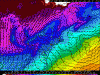
By 7AM Wednesday, the models all show the front south of Cleveland and pushing through the Snowbelt, likely with a band of heavy snow with it. By this point, lake induced instability will be extreme (800-1000 J/KG of CAPE) with equilibrium levels rising to 10-12k feet. In addition, the NAM shows very strong omega along the front (CLE briefly has -30 ub/sec!!). Any band along the front could produce very heavy snow rates, although the band will be moving so the snow may not add up a ton:
Behind the front, instability remains extreme and equilibrium heights will remain in the 10-12k foot range until mid to late Wednesday afternoon. However, the fetch will become shorter and some low-level dry air may work in, limiting additional snowfall behind the front.
The winds immediately behind the front (see the BUFKIT forecast sounding for CLE above) will be very well aligned out of the WNW for a couple of hours, so I suspect some convergence and half decent snows will hang on for a couple of hours behind the front a bit inland from the lake…mainly across parts of Lorain, southern Cuyahoga, Medina, northern Summit, southern Geauga, Portage into Trumbull and possibly Mahoning. These areas could see another couple inches right behind the front by mid to late Wednesday morning.
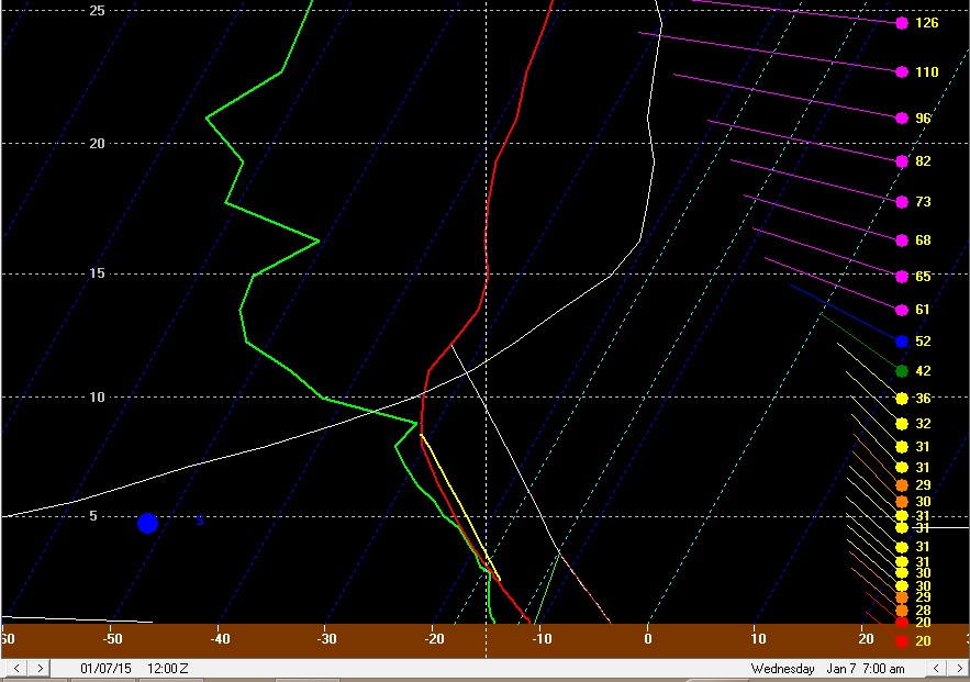
By later Wednesday morning and into Wednesday afternoon, the flow will be true NW (one of the shortest fetches across Lake Erie for northern Ohio), and the models show some dry low-level air working into parts of Michigan from Canada. Although the air over Lake Erie will be extremely unstable with high inversions, I’m worried about this dry air. NAM forecast soundings for CLE suggest it may be hard to maintain a deck of lake effect clouds at times:
The winds are very well aligned, the layer of instability is deep and the amount of instability is very impressive for a lake effect situation. However, with a short fetch and a good 25-35 knot flow in the boundary layer I have some concerns. This may be where upstream lake connections come into play:

The NAM shows a couple of things that concern me…first of all, it shows cold and very dry air (dew points below 0 into lower MI, and -20 to -30F dew points in the core of the colder air) working across the narrow and partially frozen portions of Lakes Michigan/Huron and working towards central Lake Erie late Wednesday morning into Wednesday afternoon. This would potentially limit lake effect off of Lake Erie given the short fetch. In addition, this cold/dry air pushes the Lake Michigan connection well west of Cleveland. It is very typical to get a Lake MI connection in a NW flow and that is often why there is a band on the west side in a NW flow. You can tell where the connection is by following the convergence in the wind barbs. Between the two connections close to NE Ohio, the winds at the surface are somewhat divergent. This would also limit how organized any lake effect between the two connections is.
Because of this, it would not surprise me at all if by late Wednesday morning after the front passes well south and the winds become true NW that the lake effect across the Cleveland metro and also Lake and Geauga Counties becomes very weak/disorganized for a few or even several hours, with perhaps just light accumulations in this timeframe in the higher terrain. There could be heavy snow in eastern Ashtabula County into NW PA under the Lake Huron connection and perhaps decent light to moderate snow in the Lake MI connection well west of Cleveland. Snow ratios during this time frame might not be great either due to the drier air causing the ceilings to climb above the DGZ for a few hours Wednesday afternoon.
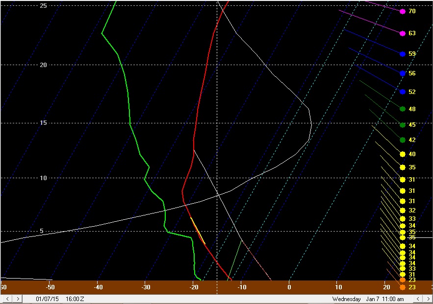
The NMM and ARW also show the cold/very dry air trying to work its way down towards Lake Erie early Wednesday afternoon:

Note how they both show one band west of Cleveland (one model shows it stronger than the other) and the Lake Huron band well east of Cleveland at the same time:
By Wednesday evening, the winds will begin backing to a more WNW and eventually W direction, which will lengthen the fetch over Lake Erie and perhaps allow some upstream conditioning from Lake Michigan and increase moisture some:
By this point, there will still be decent instability and pretty high equilibrium levels, and convergence will increase some along the central lakeshore and into the Snowbelt as high pressure moves in, so there will probably be an increase in snow Wednesday evening into Wednesday night across northern Lorain, Cuyahoga, Lake, Geauga, Ashtabula, Trumbull and possibly northern Summit/Portage that drops another 1 to locally 4” of what by that point should again be high ratio snow:
By 3-4AM the winds go pretty WSW which should confine things to the lakeshore by that point and effectively end the event for most of us…
So, how did I figure accums?
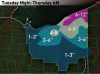
I figured 4-8” Tuesday night in Lake and northern Ashtabula Counties due to the band I expect to develop there…and then 2-3” across Cuyahoga, northern Medina, northern Summit, Geauga, southern Ashtabula and northern Trumbull as the arctic front drops south early Wednesday, with possibly another inch or two immediately behind the front across parts of Lorain, southern Cuyahoga, northern Medina, northern Summit, southern Geauga, northern Portage into parts of Trumbull, which pushes those areas to 3-5” by mid to late Wednesday morning. The arctic front could produce a quick inch or so everywhere else across north-central and NE Ohio outside of these areas. After the arctic front, I figured another 2-4” Wednesday afternoon across eastern Ashtabula County due to getting fringed by a potentially very heavy Lake Huron band…and perhaps another 1-3” across parts of inland Lorain, eastern Huron County into parts of western/southern Medina and maybe even the higher elevations in northern Ashland Counties due to the Lake MI connection there…with maybe another inch in the higher terrain in the primary and secondary Snowbelts. I think figured another 1-4” from Cuyahoga east Wednesday evening into the overnight with the last flareup I expect.
This pushes most of Lake and Ashtabula up to 6-12”, with perhaps a little more in eastern Ashtabula if they do get into the Huron connection. This gives a wide 4-8” area in the rest of the primary Snowbelt and surrounding areas. I drew 3-6” amounts well west to account for the possible Lake MI connection in that area. I didn’t feel comfortable with leaving the higher terrain in SW Cuyahoga and northern Medina in just 3-6” so I added a small 4-8” area there as well. Due to favorable orographic lift in northern Geauga I figured they could squeeze out a little more in every phase of the event so I also drew 6-12” in there. Although I didn’t draw it in on this map, I expect 1-2 feet across a good portion of Erie and Crawford Counties PA as they should also get in on the band Tuesday night ahead of the front and also the Lake Huron connection for several hours on Wednesday.
Map:
-
There wasn't any ice on that camera yesterday morning, too bad it's already icing again. The winds will shift around with the clipper going by, so hopefully that keeps the ice from forming solid until at least Wednesday night.
-
About half an inch here, roads are pretty icy. Lake effect may take some time to organize.
-
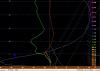
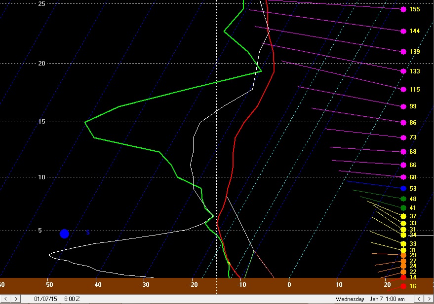
What do you guys think for the LES potential on Jan. 7th? I see 850 and 700mb temps pretty darn cold. 700mb temps down to -34C over the lake, with a 30kt NW wind from the surface to 700mb. I wonder if snow bands will organize to make for a big snow event for NE Ohio. On the other hand, I wonder if this is -too- cold and dry. Then again "too dry" seems a little dumb seeing as how the RH values aren't too bad on the GFS.
The NAM appears to show saturation and decent omega in the *small* DGZ on Wednesday, so I don't think it'll be too cold. Ratios might come down to more like 15-20:1 due to the limited size of the DGZ by Wednesday afternoon, but I figure it won't be so cold that all we see are needles falling.
The interesting potential IMO is a potentially really nice squall along the arctic front around daybreak Wednesday. The NAM shows an extremely nice cross-hair signature (omegas better than -25 in the DGZ) as the front pushes south off the lake early Wednesday, could be a period of white-out conditions with that.
We should all be getting light wrap around snow soon, will be nice to see.
-
Good to hear. Anything that falls before the clipper is a bonus. Although the clipper is looking more and more like a 30 corridor on south event. Radar looks good to our west so hopefully we can all wake up to an inch or two or snow tomorrow.
CLE ended up issuing an advisory for Lake, Geauga and Ashtabula into NW PA for tonight into tomorrow, so we'll see. There will be a little shortwave that goes by tonight which may help a half decent band develop by dawn tomorrow and persist for a few hours, possibly as far south as 422, before it starts gradually shifting up the lakeshore. Should be the fluffy snow so we'll see if a band can actually form this go around or not. Moisture depth after this evening is iffy at only 5-6k feet, with an inversion at 6-8k feet and 300-500J/KG of lake induced CAPE, so it will probably take an organized band that doesn't move too much to get a few inches. That looks possible tomorrow morning behind the shortwave, so we'll see.
-
Looking at the 12z NAM and recent RAP runs, they now bring the winds around to a solid WNW direction tonight. Granted, moisture depth and inversion heights are very marginal. The 0z ARW and NMM again spit out a quarter to half inch of QPF under any banding across the Snowbelt, but that may be a bit high. There could be an ok burst this evening with the wrap around snow showers that drops up to an inch, and then we see where any bands set up. I could see locations like 422 doing OK if the latest NAM and RAP are right about the winds. Moisture depth and inversion heights are pretty marginal (inversions around 7k feet and moisture up to 4-5k feet) so you'd have to get under a band for a little while to see more than an inch or two.
-
I'd imagine they got enough rain and will see enough wind to disperse the ice starting to form, although a warmer push of air would've been nice there too.I'm stuck at 47 degrees. Temps will probably surge prior to the frontal passage. The bad thing is that temps have been in the mid-30's all day in western OH. That's the place that warm temps and heavy precip would have been helpful for LES purposes... but not the case unfortunately. West of Sandusky seems to be the line between warm/cold.
-
As always, temps over performing in this situation. I'm surprised CLE went so conservative with highs today, easily hit 50 by 5pm. I also don't know why they are going with lows in the lower 40's overnight, I'm doubtful we drop much if at all overnight:
Zone forecast for Cuyahoga tonight:
Rain. Lows in the lower 40s. South winds 10 to 15 mph with gusts up to 25 mph. Chance of rain near 100 percent.
The airport is "finally" running a snowfall deficit for the season as of today, a whopping 0.1" below the seasonal norm. So if the clipper and lake effect this week pans out, we're still on track to have a halfway decent winter (looking at the big picture) despite one of the worst December's on record for snowfall.
Looking at their forecast graphics, they have temps quickly rising into the lower 50's tonight, but have lower 40's right about now (which is several degrees too cool) which is where that low comes from. Cincinnati is pushing 60, so I wonder if we can get like 57 or 58 as a pre-dawn high tomorrow.
-
It looks like tomorrow evening the remaining deform snow moves through. It won't be much, but some lake enhancement should occur in a WNW flow as the deform moves through so I think most of us in the Snowbelt will get an inch or two tomorrow evening. Later tomorrow night pure LES takes over. The parameters are similar to Tuesday night. There might be a little more instability, but moisture depth and inversion heights are similar. The NAM shows just a slightly north of due west wind which would keep things probably north of 322 up towards Chardon, while the GFS would be WNW enough to get the better snow as far SW as the 480 corridor out into Solon and probably even where I am. The Euro is in between. Regardless, it looks like a mainly light "event" Sunday night into Monday...1-2" from the deform/lake enhancement Sunday evening, and then another 1-3" wherever the lake effect sets up.
The GFS brought the clipper back north a little bit, with the 0z Euro and 12z GFS both showing .2-.3" of QPF across northern Ohio. Ratios will be decent with the clipper, probably close to 20:1. That does imply a 4-6" snowfall, however the snow will be quick hitting and omega looks modest in the DGZ, so I'm thinking more of a 2-4" with the clipper.
Behind the clipper the flow looks WNW with increasing moisture and instability Tuesday night, with the GFS and Euro both showing a surface trough dropping across the lake Wednesday morning. This may support a primary single band from northern Lorain and Cuyahoga points east that drops south on Wednesday, with a multi-band setup taking hold in a NW flow by Wednesday afternoon. The instability and equilibrium heights progged by the GFS are more impressive than any of the November events for Wednesday and Wednesday night with impressive moisture depth to over 10k feet. My one concern is the GFS shows very dry dew points at CLE which may hurt us with a NW flow, however the GFS is going to under-do heat and moisture flux off of the Great Lakes, so I imagine that as the NAM gets in range it will look better with the low level moisture. If we get into range and the NAM does show higher dew points, I'd imagine that the eye-popping parameters and also conditioning from Lake Michigan would allow decent snows to continue in the NW flow Wednesday afternoon into Wednesday night. It will be cold enough by Wednesdy afternoon to stunt snow growth somewhat, so ratios might be held to 15-20:1 outside of any intense bands.
The winds start going west on Thursday and eventually southwest by Thursday evening which should push the lake effect up the eastern lakeshore. So, it looks like a little snow Sunday evening through Monday...a general light snow with the clipper on Tuesday...a very good setup for lake effect Wednesday...with the lake effect winding down Thursday. Sounds fun to me at least...


Northern Ohio Obs/Discussion Part 2
in Lakes/Ohio Valley
Posted
LPR to the ESE of PCW hit -13F last night before fog and even some light snow developed, and LPR is often one of the warmer spots in the Cleveland area, so I can believe the -14F at PCW since it's in a fairly rural spot and surrounded by the ice covered Lake Erie.