

OHweather
-
Posts
4,889 -
Joined
-
Last visited
Content Type
Profiles
Blogs
Forums
American Weather
Media Demo
Store
Gallery
Posts posted by OHweather
-
-
The format CLE uses with the report twice a day between 7 and 9 pm causes funky reports. I wish during events like this they'd just send out continual updates to storm totals. Many of the reports would be just new snow since 9am. Many areas already had 2" by then.
That's true. We shall see if they clean things up in the PNS later or send out storm total numbers tomorrow. Would be nice!
8.5" is not a bad storm! This has got to be rivaling your biggest storm since early 2011 I'd think? I'd have to imagine double digits will be easy for Cleveland proper at this point.
-
Some of the LSR's don't jive with eachother or with what I saw myself when I left or have heard from other people who should be able to provide a reasonable estimate. I can say no way to the 3.8" in Twinsburg since I had about that much a couple miles east when I left at 2:30 and they didn't get any rain, just snow most of the day.
Also: 3.0" in Old Brooklyn when CLE a few miles west had 4.4" just through 1PM? I've heard "at least 6 inches" from a few people in the Youngstown area, but Austintown only had 4.0". Shaker Heights had 4", but our western Geauga County posters have 7"+, and Mentor has 7.2". Clinton only has 2.5" but a weather fanatic who plows snow in Green a few miles east said "at least 4 inches". The 6.5" spotter report from west Akron pretty much voids the 3.8" in Twinsburg and the 2.5" in Clinton considering they were mostly snow in southern Summit until about an hour ago. 3.5" in Hiram also seems low but there's nothing else nearby to compare it with.
Call me a weenie for thinking several reports are so low, and maybe I'm wrong, but with a wet snow and no wind I wouldn't expect these discrepancies. Given the CLE METARs, what was falling at home when I left and what you guys have said, especially since some of you have been or are snow spotters, I think the low reports are suspect.
-
Thanks guys, glad this ended up being a good storm up there! Oddly, some areas even inland will at least approach the low end of my map from yesterday and exceed the high numbers on my map from today. I guess that's why you put a range on snowfall projections.
As for CLE, I believe they measure every 6 hours, so there's a good chance that 4.4" was just through 1:00PM.
-
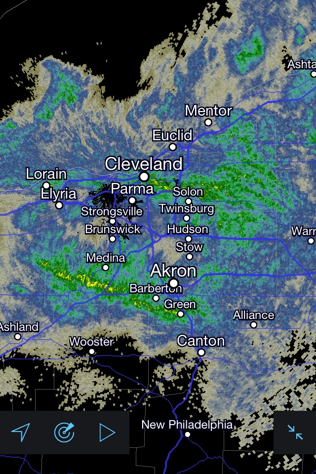
How much snow are you guys up to? I see the dry slot keeps filling in over the northern two tiers of counties from Lake Erie.
-
Heavy snow with large flakes here now. Leaving shortly. The drive down to about CAK will be fun, then probably just drizzle father south.
-
Dry slot appears to be filling in a little bit.
-
The most recent run of the HRRR does get a mix all the way to the lakeshore by late evening, but shows over half an inch of liquid falling as snow before then. Even if CLE mixes that'd put them at about 8" for the storm before the mixing occurs.
-
1" per hour rates at CLE for the last two hours. Looks like 3" or so so far here. Anyone in the lower two zones on my map is already on the low end of the expected totals and lakeshore areas should have little trouble getting there. I'll feel like a jackass if my first map performs better than my "revised" one.
-
Looks good. I think 6" is definitely reachable for the northern parts, especially since 2-3" has already fallen. The question is how much mixing and for how many hours tonight that will result in getting totals near the higher end.
When it comes to snow, I've quickly become a pessimist over the years. It's not hard after we've been burned dozens of times over the past 5 years or so with scenarios that play out just like to today, slow trends north or slow trends south. It was on Friday that the CLE AFD was still mentioning the best snows in the extreme southern part of their CWA, that band has now easily shifted over 150 miles northward.
I'm glad I never bought the hype and with every run that looked golden for us I knew that would change.
If 6 or 7" of snow falls, that's an awesome storm, but seeing that there'll be twice that not too far away does sting, especially after last winter where we were fringed by every storm in a similar way.
I feel like up through the winter of 2010-2011 we had more things trend in our favor than not...that was a very snowy decade in Cleveland leading up to that. Since then, even with a good seasonal total last winter, nothing has really broken our way in terms of major snowfall. So I understand being a pessimist.
It's tough trying to forecast for the general public in this town. Because every met in this town probably has all of these busts burned in the back of their brain, but it would also not be good to call for a 4-8" storm and have a foot fall or something along those lines. The one red flag that had me kind of concerned was the models never actually stopped inching north. I thought yesterday morning when all models were zeroing in 24 hours out we'd be good and the trend would stop, but it didn't.
I still lean optimistic, and eventually one will break our way, but for now we'll still have to wait for the big one.
-
Don't have much positive to say. I think CLE still stands a good shot at seeing over 6", but the potential this thing had of over 10" won't be realized. CLE could barely stay all snow, as the NAM and GFS both show either only a small above freezing layer or keep the whole column at or below freezing at CLE...in addition, the precip could be somewhat convective this evening, which could cause enough dynamic cooling to keep locations all snow. This will definitely be a big bust inland, considering 48 hours ago a lot of outlets were worried about the lakeshore being too far north for heavy snow.
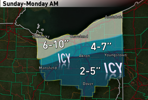
I sarcastically told someone early in the week that this seemed like a storm that looks great for CLE until 24 hours out and ends up screwing us...up until yesterday I really didn't think that would happen though. Here's my "updated map", and it may still be generous. Most areas should hit the low numbers, but the high numbers may be a stretch.

-
Here’s my forecast…
Tough call due to continued north shifts on the models bringing mixing issues and a dry slot closer to Cleveland…
This storm will come in three “phases” across Ohio…the first phase will be overrunning snows late Saturday night into the middle of Sunday afternoon…the second phase will be a trowal type feature as we get on the nose of strong low to mid-level WAA ahead of the mid-level low late Sunday afternoon through Sunday evening…the third will be a weak deformation zone/some lake enchantment late Sunday night into Monday morning.
As for the low track, I don’t buy the track up to YNG that some models are trying to hint at. Although the models have steadily trended north for days now, I still believe there’s a cap to how for north the surface low goes. Even the super amped SREF members don’t show the trough taking on a negative tilt as it passes through Ohio, so the surface low track should be more W-E and I’d expect it to be near I-70. I currently like a GFS/Euro blend as the last couple runs of those two models have been fairly consistent with mainly cosmetic changes. The GFS is slightly north of the Euro.
The overrunning snows look mainly light to moderate. There will be a fairly deep DGZ during the overrunning snows, but lift within the DGZ won’t be strong and surface temps won’t be far below freezing, so ratios may not be great during the overrunning snows. Areas north of route 30 will be on the nose of pretty good WAA at 700mb during this phase of the storm and will get a nice boost from the right-rear quadrant of a upper level jet streak, so I do expect moderate snow at times during the overrunning. I could see the overrunning snows producing 3-6” by mid Sunday afternoon mainly in the northern couple tiers of counties.
The phase of the storm where northern OH could get into a trowal like feature is when the heaviest snow rates may occur, and it’s also the most uncertain part of the forecast IMO. Northern OH will be under fairly good upper support in the right-rear quad of another upper level jet stream and left-exit quad of another jet streak. Northern OH will also be on the nose of a 50 knot 850mb jet with high theta-e air within that LLJ, and Northern OH will also be on the nose of another burst of strong 700mb winds. This could support elevated convection and heavy snow rates. This phase of the storm looks to last about 6 hours late Sunday afternoon into Sunday evening, and snow rates of 1” per hour or heavier are possible at times. This phase could produce another 4-8” of snow in favored areas.
The weak deform will mainly affect NW OH and SE MI as it looks now. The 700mb low track will be over Lake Erie which suggests north-central and NE OH could dry slot at this point. The weak deform could add a couple inches to parts of NW Ohio. Some lake enhanced snow will likely occur through Monday morning until the deeper synoptic moisture pulls out. With a NE wind going N this lake enhancement could favor Cleveland points west.
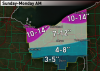
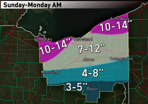
All told, with models still insisting on over an inch of QPF, the long duration of the storm and a couple long opportunities for moderate to heavy snow, I can easily see how CLE gets over a foot of snow, and considered going 10-14” across all of northern OH. However, a GFS/Euro blend takes the 850mb low track right over Cleveland. As a general rule of thumb with storms that come from the west or southwest, mixing will get up to the 850mb low track, regardless of what models show. The heaviest snow is typically north of the 850mb low track. So, even though I could see how this produces a foot in Cleveland, I decided to hedge a little bit and give myself some wiggle room
.
I do think MFD, CAK and YNG mix at times, and the mid-level low tracks passing well north of those areas also supports the heaviest snow being north of that corridor.
-
Excitement building as the 0z models trend strong with the storm but still keep northern Ohio all snow. All models show 0.9-1.2" of QPF up to or very close to Cleveland.
I understand some reasons to be cautious and have been burned by some storms the last few winters myself. I also agree with some of the reasons to be somewhat optimistic that Trent gave. My preliminary thinking was 6-10", and tomorrow I'll put together a forecast. Given the potential for an extended period of overrunning snows and then heavy snows during the evening on the nose of the LLJ, local amounts could top a foot. But I'll decide what I want to do with that on Saturday.
Cool. C'mon, doesn't a white knuckle drive through the hills sound fun?
It does, but at the end of the day 200 miles is a little too much white knuckling

I'm debating staying until Monday morning, but have work to turn in Monday at noon so I'm not sure what I'll do. This could be one to be here for.
I'm supposed to drive up to Norwalk Ohio leaving North Central In. at 4am Monday. I usually take 69 and cut over on 30 then back North. Any guesses on if the roads will be passable if this thing pans out?
The snow will start lightening by that point in NW Ohio, but the snow will be powdery and winds will be gusty, so you could have some decent issues. NW Ohio can be nearly crippled by 6-12" of snow, especially if it's windy. Maybe since 30 is a main road they'll keep it clearer though.
-
Driving up shortly...although ill probably try to get out Sunday before the heavier stuff hits.Thanks for the info. You coming home this weekend?
-
SUN 00Z 01-FEB -4.4 -6.3 1024 69 21 0.00 552 533 SUN 06Z 01-FEB -3.0 -6.2 1022 73 88 0.00 550 533 SUN 12Z 01-FEB -2.9 -6.5 1021 96 98 0.09 547 531 SUN 18Z 01-FEB -2.0 -6.3 1018 92 97 0.15 545 530 MON 00Z 02-FEB -5.1 -6.2 1014 92 100 0.24 541 530 MON 06Z 02-FEB -8.4 -7.3 1010 87 100 0.26 534 526 MON 12Z 02-FEB -10.6 -11.8 1015 80 98 0.15 529 517 MON 18Z 02-FEB -11.6 -14.9 1023 66 22 0.02 531 513
0.91" for CLE
-
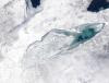
Awesome! The Chardon cam still shows heavy snow even though the returns have weakened some since earlier this morning. It's still probably snowing 1" per hour in Chardon. I figured there'd be some enhancement, but if you got 8" last night that's a lot more than I'd ever envision off of a frozen Lake Erie with a NW wind. Very impressive. Imagine amounts if the lake was open.
-
Although it's possible the models trend back weaker for the Sunday-Sunday night storm, it's highly unlikely IMO. The polar vortex over Hudson Bay will cause the system to be more of a bowling ball (W-E mover) than a cutter, so I think northern OH probably stays all snow. Want to look at the 12z Friday models before making a call but I don't think a widespread 6-10" or so is a bad starting point.
-
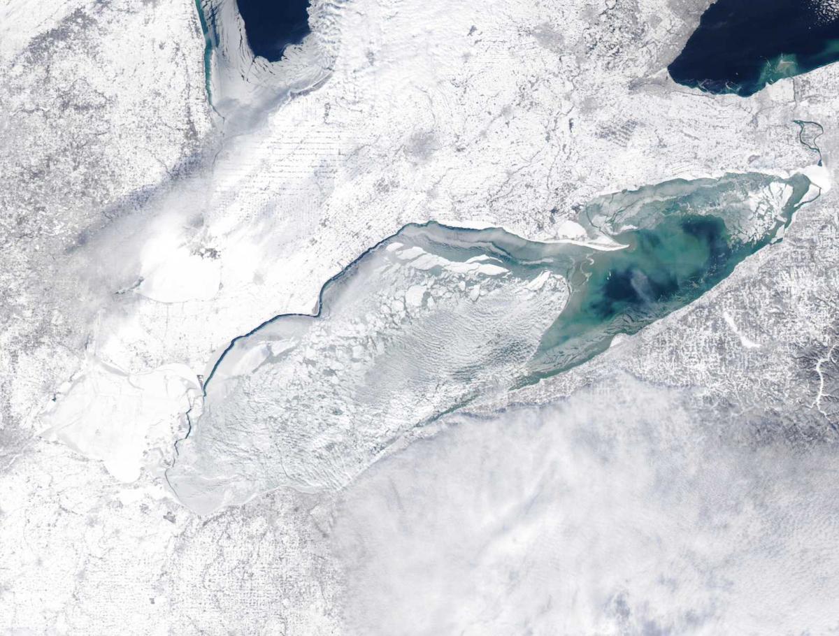
Thanks for the ice report. Been too many clouds lately to get a good satellite shot. If the lake were unfrozen this would be a good 4-8" event with a couple of troughs moving through tonight. As is I'd generally expect about 1-3", maybe a local 4" amount in northern Geauga. Good moisture and decent inversions with a NW wind and high snow ratios will probably be enough to allow for light accumulations tonight. Even though there isn't much open water, any moisture picked up plus the synoptic moisture and perhaps some upstream lake moisture should combine with frictional convergence as the wind hits the land and higher terrain and ring out light snow.
Sunday still looks interesting.
-
I could see a pretty decent burst tomorrow late afternoon and evening of synoptic snow as the cold air starts pouring in, with some LES continuing afterwards. With an open lake I think this setup could produce advisory or warning criteria snows because there's pretty good synoptic moisture and respectably high inversions through most of tomorrow night, but with so much ice expectations need to be tempered. For now I think 2-4" in the Snowbelt and 1-2" elsewhere is reasonable for tomorrow night.
-
I will be in NE Ohio this weekend and am liking the look on the models for Sunday. A little energy ejecting out of the southwest and partially phasing with a trough diving in. Enough to get a half decent storm, but a full on phase and Detroit cutter will be avoided unless the northern stream energy trends a lot slower. I have to drive back to OU at some point Sunday afternoon or evening, could be a sporty drive if the models right now have half a clue.
-
Clippers don't tend to trend back north last minute, so I'm not too optimistic for you guys. Of course here it still looks like a rain to light snow shower scenario. The 12z Euro still suggests 2-3" up to Cleveland and 4" for Akron so you'll probably still get snow...but 3-6" amounts will probably set up from like Mansfield to Dover.
-
There's some reason to be kind of optimistic about tomorrow's clipper...
You guys will get into the left-exit quadrant of a jet-streak for a few hours tomorrow morning, and will also be in an area of mid-level frontogenesis for several hours as well. The NAM shows the best lift juxtaposed in the snow growth zone tomorrow morning as well. I could see a few hours of moderate snow working out, I'd go with a 1-3" forecast personally. I can see how someone gets 3" or so but think it would be in a relatively narrow corridor.
As for Sunday/Monday, the Euro shows the shortwave with that "super clipper" closing off at 500mb over the Ohio Valley and show it taking on a modest negative tilt as it passes overhead (the e-wall plots are pretty low resolution, some higher resolution sources show a closed off contour at 500mb). That smells like a potential overperformer, but it may end up being better for Columbus than you if the GFS and Euro hold their track. We'll see.
-
Some nice bursts of snow with a trough pushing through. I bet the ice did break up enough to allow some extra moisture to get picked up off the lake...someone could get 2-3" in Medina or south of Akron where the better band is. There were several rather unexpected light to moderate LES events last winter after the lake seemed to freeze due to winds moving the ice around and making holes, we could get that this year at times too.
Edit: Yeah, this ice wasn't that thick as Trent suggested. Can definitely see how several hours in the 40's Saturday and good southerly winds made a nice hole along the southern shoreline. We won't be clear again for a while, although it won't be cold enough to really solidify things this week:
-
The folks at CLE just can't get enough of the warmth.... They should look for jobs in the south. Up to 42/32 Imby. Not a lot of melting with the low DP. The snow is compacting though.
The 12z gfs was a nice hit with the clipper. Looked like the euro brought it right over us though. Great post on the upcoming pattern btw.
Thanks, hopefully the pattern can deliver at some point. Probably will snow on January 30 or February 1 as those are when I'm driving to/from home next. We hit 54 in Athens, just snow piles left here, although that's been the case for a few days.
It's possible the clipper drops a 1-3" type snow, the models keep edging south with it, so it's looking better for northern Ohio now.
-
Now we have one day in the mid 30's counting as a January thaw next weekend lol
ONE TROUGH AFTER ANOTHER ROTATES SOUTHEAST INTO THE AREA THROUGH THE
PERIOD WITH A TREND TOWARD BROAD UPPER LEVEL RIDGING BY THE WEEKEND.
SURFACE LOW PRESSURE IS PROGGED TO MOVE EAST AND OUT OF THE AREA ON
WEDNESDAY TAKING THE REMAINING PRECIPITATION WITH IT IN THE FORM OF
SOME LIGHT SNOW. OTHERWISE...AS LOW PRESSURE EXITS STAGE
RIGHT...MORE ARCTIC AIR IS POISED TO SLIDE SOUTH INTO THE FORECAST
AREA WEDNESDAY NIGHT THROUGH FRIDAY. THE GLANCING BLOW OF THE ARCTIC
AIR WILL EVENTUALLY START TO SHIFT EAST OF THE REGION INTO MAINE AND
NOVA SCOTIA. HIGH PRESSURE BUILDS EAST AND WE SHOULD START TO SEE
THE EFFECTS OF ANOTHER JANUARY THAW BY THE EARLY PART OF THE WEEKEND
AS WARM AIR ADVECTION TAKES PLACE. BUT WE CANT GET TOO EXCITED AT
THIS POINT AS ANOTHER UPPER LEVEL TROUGH IS EXPECTED TO DIVE INTO
THE AREA BY EARLY NEXT WEEK BRINGING THE WARMER AIR TO AN ABRUPT END.
BUT IN THE MEAN TIME...THE ARCTIC AIR WILL SETTLE IN OVER THE LAKES
AND WE COULD SEE AN OUTSIDE CHANCE FOR SOME RESIDUAL LAKE EFFECT
SNOW TO DEVELOP ACROSS THE REGION. LAKE ERIE IS ABOUT THREE FOURTHS
ICE COVERED WITH A HOLE IN THE EASTERN PORTIONS UP BY BUFFALO.
ALTHOUGH...WE CANT RULE OUT THE LAKE MACHINE BECAUSE WE HAVE HAD
EVENTS OF SNOW WITH A COMPLETELY ICE COVERED LAKE DUE TO MOISTURE
FLUX FROM THE ICE ITSELF AND THROUGH THE CRACKS.
WILL DROP TEMPERATURES BACK A FEW DEGREES DUE TO THE COLD AIR
EXPECTED IN THE LONG RANGE.The Tuesday-Wednesday clipper could be somewhat interesting, but I think it might slide just too far north for you guys. And then we'll go from there.
Northern Ohio Obs/Discussion Part 2
in Lakes/Ohio Valley
Posted
Last night's 0z Euro for the win? Here was the map:
Maybe just a little, tiny bit too far south with the cut-off. Euro was consistent with its 12/0z runs yesterday, but all the short term modelling made me want to reduce totals this morning.