OHweather
-
Posts
5,044 -
Joined
-
Last visited
Content Type
Profiles
Blogs
Forums
American Weather
Media Demo
Store
Gallery
Everything posted by OHweather
-
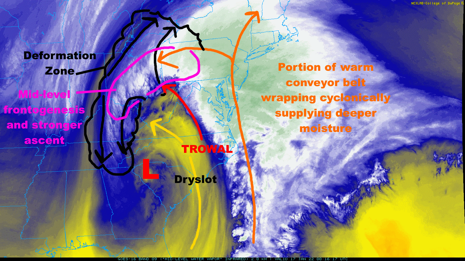
Copying over from the other Ohio thread... Big snow band starting to take shape parts of southern and eastern OH, and will ramp up more over the next few hours as it slowly moves north-northeast Multiple things contributing...THIS IS CLASSIC...you have weaker stability on the edge of the dry slot which can allow for slantwise convection (which is what typically occurs in mesoscale banded snow). You also have a TROWAL nosing in from the east (trough of warm air aloft), enhancing the mid-level temperature gradient. You already have a nice deform zone and some mid-level fgen, and that means ascent/rising air, which will cool the atmosphere further (and should gradually cause any pockets of mix to go away through the evening). This cooling will also increase the temperature gradient on the edge of the TROWAL, strengthening the fgen further and causing the band to really rip. Definitely some positive feedbacks here. The branch of the warm conveyor belt wrapping cyclonically into the deform zone is adding some deeper moisture to. Parts of eastern Ohio will absolutely rip snow this evening into the overnight. Travel will be nearly impossible, this is a high-end set-up for our region (and this will go into W PA, W NY, and eventually S Ontario too). The very heaviest may be east of CLE and CAK but this is an outstanding synoptic snowstorm for this region. I feel silly for being timid on the west trend pulling this into CLE until today. Sort of makes up for the last 6 weeks of not snowing at all.

-
Big snow band starting to take shape parts of southern and eastern OH, and will ramp up more over the next few hours as it slowly moves north-northeast Multiple things contributing...THIS IS CLASSIC...you have weaker stability on the edge of the dry slot which can allow for slantwise convection (which is what typically occurs in mesoscale banded snow). You also have a TROWAL nosing in from the east (trough of warm air aloft), enhancing the mid-level temperature gradient. You already have a nice deform zone and some mid-level fgen, and that means ascent/rising air, which will cool the atmosphere further (and should gradually cause any pockets of mix to go away through the evening). This cooling will also increase the temperature gradient on the edge of the TROWAL, strengthening the fgen further and causing the band to really rip. Definitely some positive feedbacks here. The branch of the warm conveyor belt wrapping cyclonically into the deform zone is adding some deeper moisture to. Parts of eastern Ohio will absolutely rip snow this evening into the overnight. Travel will be nearly impossible, this is a high-end set-up for our region (and this will go into W PA, W NY, and eventually S Ontario too). The heaviest may be east of some of the posters in this thread, but it's really an outstanding set-up for our region!
-
Radar is looking great! Frankly wouldn't shock me if most areas east of 77 have double digits by dawn with lake enhanced / effect to follow. This has turned into quite a storm. Was telling my dad, normally I'm excited for days before the snow starts. This had to trend so far to get to this point that it hasn't hit me that I will have an easy 6 or 8" by morning and quite possibly 10"+! Those of you in Geauga will get a larger lake contribution than I will. Plenty of snow to go around.
-
A lot of hi-res models had mixing all the way into NE OH and NW PA for a time later this evening, so I don't think the mix is a surprise. It "should" go to snow through the evening as better banding develops. I wouldn't call a bust yet but you'll know which way it's going in the next few hours if banding starts cranking and flips everyone back to snow. Along the OH river went back to snow as heavier rates developed over the last hour or so.
-
HKT itself is a nice, little town. Very wooded and hilly area so if you're into the outdoors there's some stuff to do. Even an ok little ski resort about an hour north of Hackettstown in Vernon, NJ. But, key words here are little town and wooded. If you're looking for more of a social life you may end up closer to Morristown. If you do look for an apartment in Hackettstown yourself feel free to reach out, I know people who lived in or still live in pretty much all the places in Hackettstown. Anyways, agree that I like where we're at. Nice little coating down here on all surfaces. Glad Summit and Cuyahoga finally are under warnings as I don't think it'll be even close to not being worth a warning, especially the eastern half of both counties. Could see them needing to add Wayne and Medina too just eyeballing the radar.
-
First few flakes have started here.
-
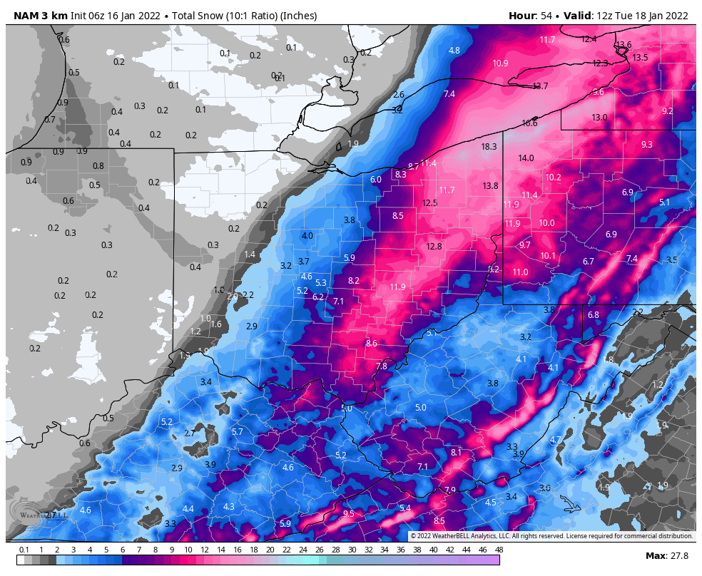
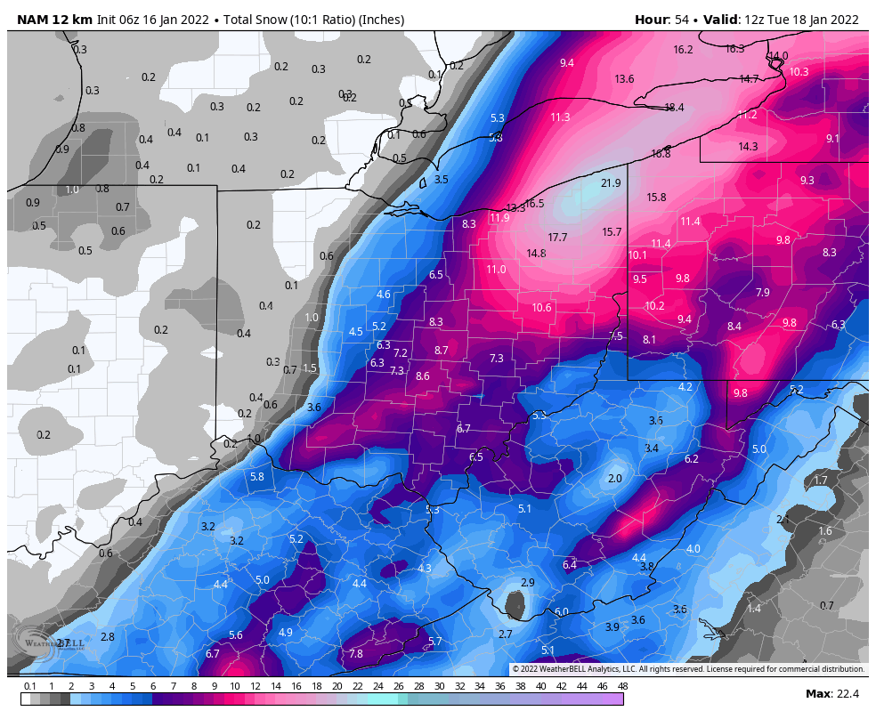
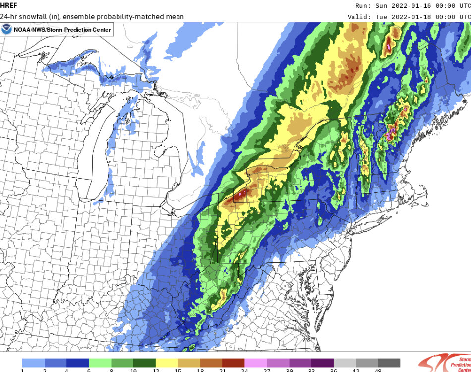
12z HREF pretty wet along and east of 77...maybe shave a little off due to low ratios to start, but a good idea IMO. The hi-res stuff is now west closer to the globals and may handle amounts and the cut-off with the very heavy band better. Someone may really get crushed in W PA or SW NY, and that could clip far eastern OH. 6z NAM probably too far west but this is a nice compromise.
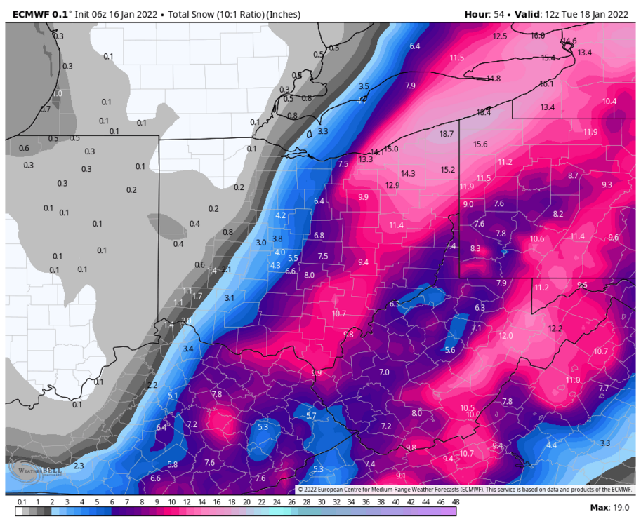
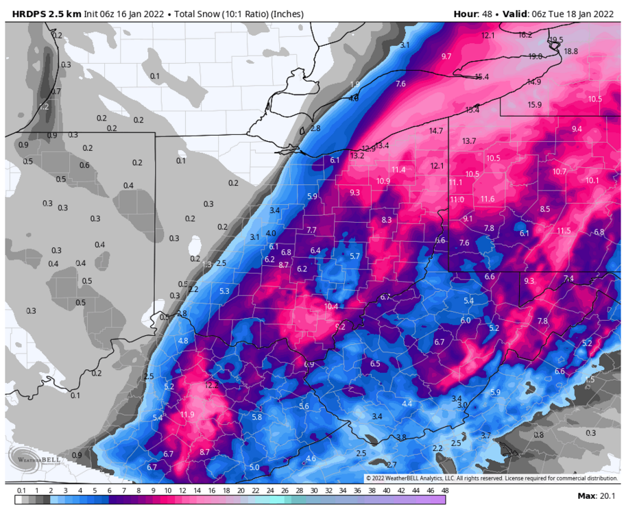
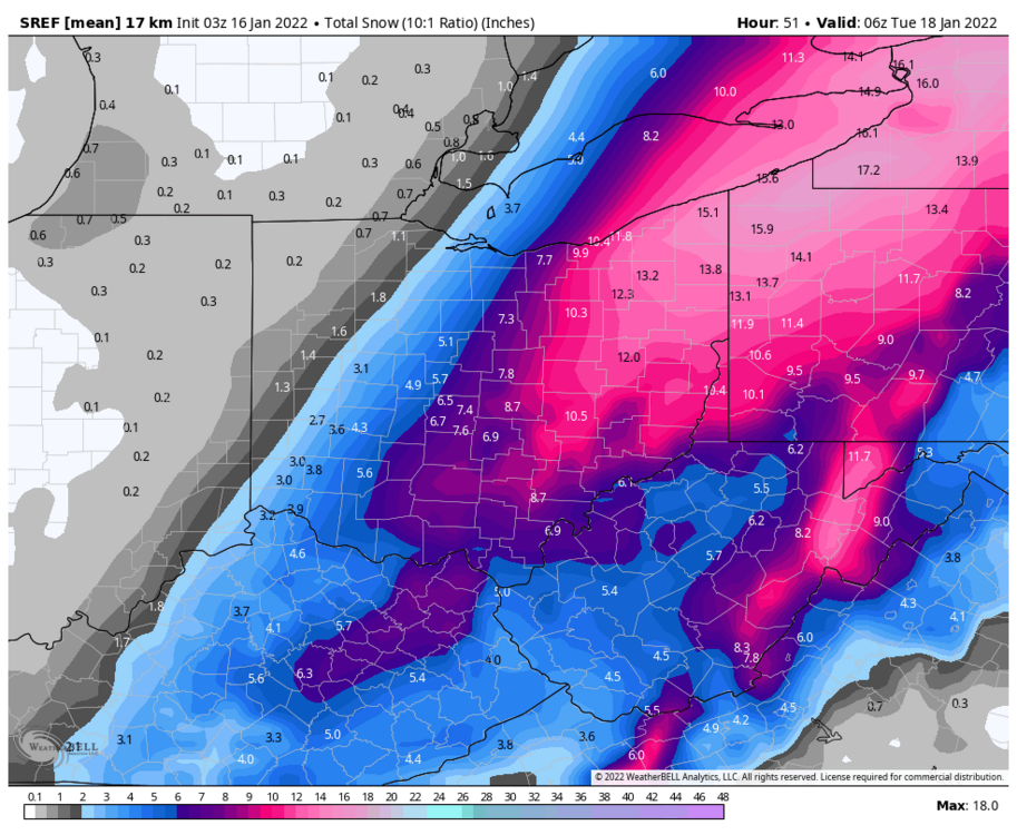
.thumb.png.cdc3b751fec3bc0286d1f476ffe6c6b9.png)
-
The 6z NAM and RGEM were pretty far west. The hi-res stuff was well east yesterday and came way west. Feel like the 0z hi-res/HREF mean (the last image in my previous post) is a good starting point for the western cutoff (and it could be slightly too far east still IMO), and also max amounts where the heavy band pivots and where lake enhancement occurs. Will be curious to see the 12z run of that (and everything else)
-
Some pretty fun runs last night…the models that were west largely held, and the hi-res stuff that was east came west, though still has the Cleveland and Akron area on the fringe of heavier snow. 12z runs shall be interesting. This is shaping up to be decent in Cleveland and fairly memorable farther east.


-
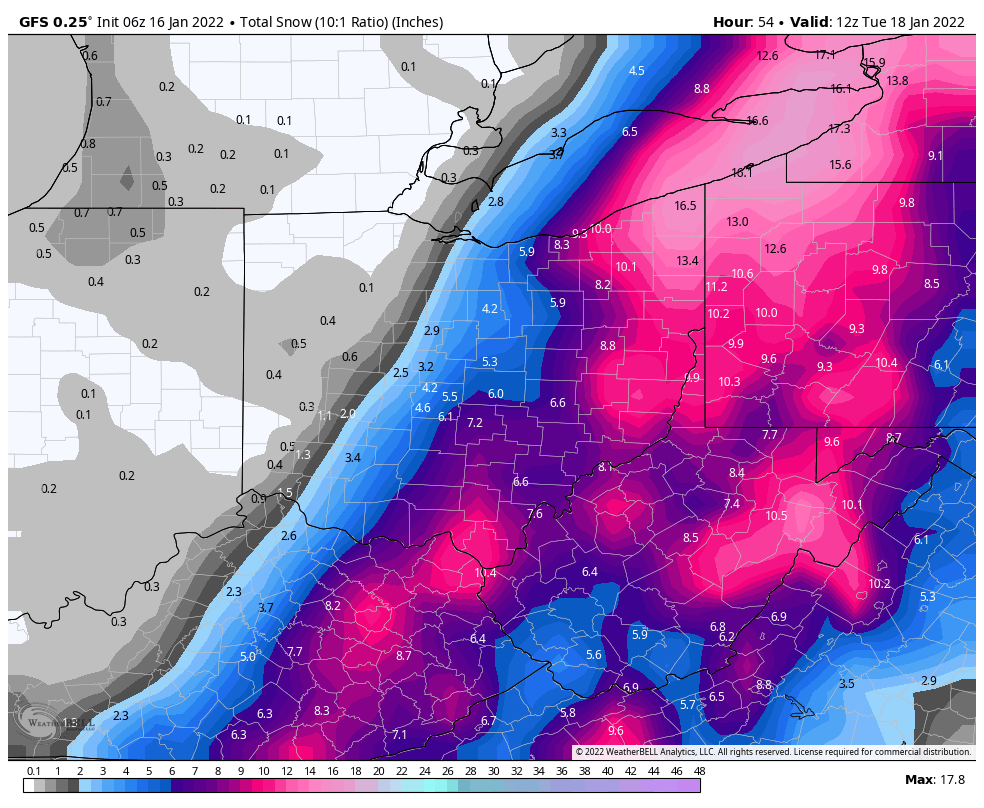
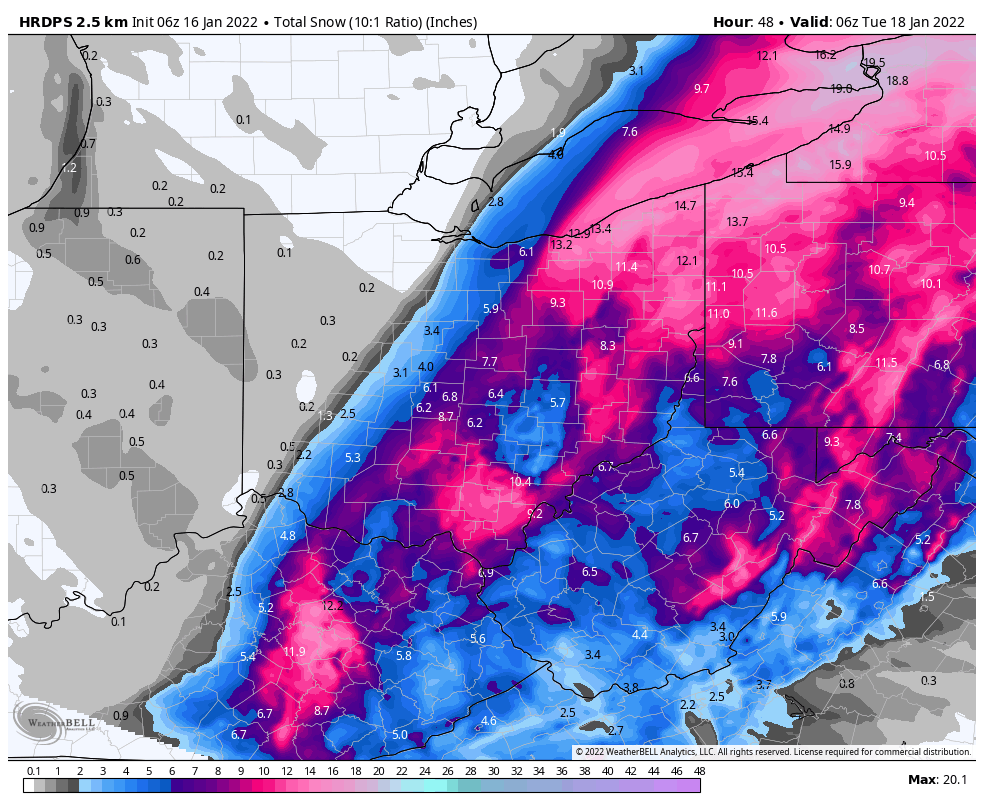
Ha, Mars is based in Hackettstown, NJ where I was living the last few years. Small world! Congrats! While a last second nudge east is still possible with a low track east of the spine of the Apps, which causes me to want to lean a little low for the Cuyahoga and Summit County area, advisories at least seem like a fair bet for the eastern half of those counties, and if we see a nudge west warning amounts could get to Cleveland and Akron. Given some potential for less than advisory I can see issuing watches as a compromise, and then decide on nothing vs advisory vs warning tomorrow morning. Am nervous having nothing out when a small west shift brings warning amounts in with snow starting in 24 hours. Here’s what I’d do I put W’s in the CLE counties I’d have in a warning and W’s in the counties I’d have in a watch. Ok j/k I’d have warning where we have it and watch where we have advisory or nothing. I’d be very close to warning on Stark, Portage, Lake and Geauga too. I don’t really qualm with our current storm total snow forecast but precarious situation on the western fringe and having no headline makes me nervous. Curious to see the rest of the 0z models, expect a band of 1-2” per hour snow on the NW side of it’s a sharp gradient to much lighter amounts. Feel it’s likely the band at least gets into the easternmost tier of NE Ohio counties but if it gets west it would drop warning criteria snow. Feel like anyone east of 77 is in play but again feel best about the PA boarder counties and into PA. Where it pivots, perhaps somewhere near Erie or Buffalo, 18”+ of fairly wet dense snow is likely.
-
This is gettin close to being a memorable storm for CLE and CAK on east in Northeast Ohio. Feeing good about the YNG area and better about the Snowbelt. CLE still seems slightly in the outside looking in but the 0z NAM wasn’t a bad start. Will be curious to see the rest of the 0z models! Lake enhancement may add a fair bit east of CLE too. Banding May nuke on the northwest side of the storm, definitely will hit NW PA I think but may edge into NE Ohio, with a sharp cutoff to the west.
-
Well, models aren't shifting east or if anything, have edged west a bit. Feel like we'll probably see the watch expanded a row of counties west overnight tonight given these trends. Will be another day of interesting runs on Saturday! It'll be a sharp cut-off from warning criteria snow to just an inch or two, so small shifts can make a big difference for the Cleveland area.
-
Haha I did not (Sullivan is the name to look for). Probably won't have a part in any AFDs again until some point next week. Am in tomorrow but doing other stuff, then am off through Monday. I think at this point we're done with large trends. The big picture isn't changing. So for a place like Toledo I wouldn't be optimistic. I could be wrong...2-3 days ago I didn't think Cleveland had much of a shot...but I don't see a big NW trend in the cards. I can see subtle wiggles east or west. I personally feel there's a slightly better shot at warning criteria amounts in CLE's easternmost county than the AFD led on (though he certainly didn't rule it out). The northern stream interaction is tricky...if it dives in farther SW and sort of "sling shots" the storm a little more due N (as opposed to NE) for a time it may help, but if it dives in faster and isn't farther west it may also kick the larger storm east a bit quicker. I think there will be a heavy band that produces warning criteria snows near the NW fringe and a sharp cut-off to negligible amounts (and some lake effect/enhanced Monday into Monday night, which could help some even if the heaviest synoptic snow stays east...but there are mixed signals on if the LES is anything of note). My gut feeling is that warning amounts (6"+) get into Mahoning, Trumbull, and NW PA in CLE's CWA. However, I also think it's a sharp cut-off, and that there may only be a one county wide row of advisories west of that before dropping down to sub-advisory amounts (criteria is 4" for an advisory, guessing a 2-4" forecast would get one given lack of snow this season and impacting a Monday AM commute, so we'll consider "sub-advisory" a 1-3" forecast or less). I can see warning amounts getting one more tier west of what I just laid out (so to Summit/Geauga) with a west trend...can also see it edging east a county or two. That's the general zone I'm eying for the western edge of the heavier snow. LES will be a bit of a wild card either way...something like the RGEM only gets the heavy deform band to YNG and ERI, but at the end of the run has a look of moderate lake enhanced snow persisting well into Monday for the CLE area.
-
You can still get organized bands with strong winds, but if there's shear the stronger flow can make them harder to consolidate. The bigger issue is the stronger winds limit how much time the air spends over the lake. For the most part with lake effect, the air moving over the lake is not initially moist and unstable enough to produce heavy snow...but while moving the lake, heat and moisture flux from the water modify the air to the point where it can become moist and unstable enough to produce heavier snow. Stronger winds limit the time for that to happen. We have gotten good lake effect events with similar wind speeds as Monday before, but usually the airmass is already more humid before hitting the lake and / or there's an upstream connection or synoptic snow ongoing (which would be more lake enhancement)...in those cases, it doesn't take as long for the lake to modify the air over it to the point where you can get good snow. But in yesterday's case, with a dry airmass, no good upstream connection from Lake Michigan, and rapidly expanding ice over the western basin (which doesn't immediately kill the heat/moisture flux, but does limit it) it all added up on top of the stronger winds. Based on some glimpses through satellite today when it briefly cleared over part of the lake, your guesstimated ice map above is pretty close...it's locked up from just east of the islands points west at the moment, though as NEOH mentioned the winds over the next few days will shift it around a bit at least so it's not totally frozen solid yet. The system Sunday night into Monday is getting closer...my current gut feeling is that it gets too far southeast before phasing to be a credible threat for us, but models have been trending towards diving the initial shortwave so far west that it's slower and farther northwest when it rounds the corner, which is what we'd need as it'd phase with the shortwave diving out of the Midwest closer to the Mississippi Valley as opposed to over the Southeast...so another shift slower / northwest makes it interesting. There's some blocking in front of it but not enough to totally rule out snow into OH if it phases earlier. I'm not yet optimistic but it's a little closer than I would've thought even 24 hours ago.
-
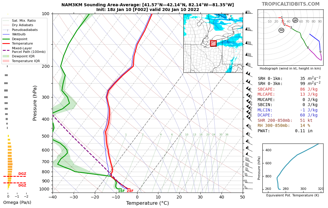
This isn't a perfect proxy of the actual environment but is close, a near-initialization sounding off the 18z hi-res NAM over the lake. A few issues I think... There is some shear as you mentioned, with more westerly low-level winds veering somewhat more northwesterly in beneath the inversion. That will make it harder for a band to organize. The other issue is the flow was a little stronger than Friday's event, 30-40 knots below the inversion over the lake...was on the grids for winds today (ignore the previous comment saying I wouldn't be in the office today, that made for a fun morning on my part) and can say that almost every model was at least a few mph too weak on the winds, especially over the water compared to what was verifying. That didn't help, especially since the atmosphere was fairly dry. Lack of good upstream connection, dry airmass, and stronger wind over the lake isn't good. The other thing that stuck out to me was that winds over the central and western nearshore waters actually went WSW for a time, similar to on land, and there wasn't as great of a temperature difference between over the water and on the land as last Friday. Think that caused a lack of convergence too, so nothing to focus a band. There was better convergence near Erie and they did get a few inches today from parts of Ashtabula County into inland Erie County. Overall, think the dry airmass, no upstream help, stronger winds, shear, and lack of convergence all added up to the disorganized appearance today. Just not enough to really focus the bands. I think after Friday's event overperformed a bit with an upstream connection into the east side and a good band there, that when models hinted at some similarities there was an urge to jump on it again. It wasn't unfounded but there were some negatives to overcome. I thought we'd get more than we did! Have gotten a tenth or two this evening here.

-
Definitely a dud in NE Ohio. Not sure if Erie County has gotten more, satellite looks better out that way. Winds will turn NW over the next few hours and a lot of areas will see snow, perhaps with a bit more organization briefly along the trough, but nothing really notable in the cards for this event it seems.
-
Looks like a couple of W-E bands set-up off of Lake Erie during the day Monday...one from around downtown or the immediate east side into southern Lake or Geauga, perhaps similar to the area that jackpotted the other day, and perhaps another towards Erie or just east into eastern Erie County. As a trough pushes through Monday evening winds go northwesterly, and everything should push inland pretty well this time with a stronger flow and not the same pressure pattern discussed above with a strong trough to our north keeping the winds backed like we had on Friday. My thought is that conditions are sort of "eh" for heavy snow through a good part of Monday. There will be accumulations beneath the bands with good ratios, but instability and inversion heights are marginal and it's pretty dry...plus, a bit more wind and a little more ice over the western basin than the last event. That said, strong low-level instability and the DGZ basically encompassing most of the cloud layer on Monday should still yield accumulations under the W-E bands. Conditions peak for a few hours later Monday and Monday evening, so activity should become more intense, but winds will be starting to go more northwesterly by then. This could be a set-up where a WNW-ESE oriented band hits parts of Lorain, southern Cuyahoga, Medina or Summit/Portage for a few hours and drops quick accumulations. We haven't seen that yet this winter. Thereafter, it'll be NW flow multi-bands and upslope the rest of Monday night into early Tuesday before shutting down. The NW flow stuff should mainly be light (but may still be pretty fluffy and add up a bit), with the exception of a Lake Huron connection into NW PA or far SW NY which could add up better Monday night into early Tuesday. My thought is up to a few inches from any W-E bands on Monday...then a quick spray in the evening as everything shifts inland with many getting a nice quick burst, and perhaps a briefly organized band from the west side into the secondary Snowbelt in the evening that may drop up to a few fluffy inches...then lighter NW flow stuff, with some light / fluffy accumulations in the higher terrain or under any weak upstream connections in Northeast Ohio Monday night into early Tuesday but perhaps better accumulations under the Lake Huron connection into NW PA or far SW NY. My overall feeling is that this is largely an advisory criteria event for the primary Snowbelt, though the Huron connection could be enough to give parts of Erie County the 8" in 24 hour warning criteria. The west side and secondary Snowbelt should see some light accumulations Monday evening into Monday night, though for the most part should be less than 2", with the exception of perhaps a WNW-ESE band from Lorain County towards parts of Summit/Portage Monday evening that can drop up to a few fluffy inches in a few hours before breaking up. Curious to see what those in the office do (I was off over the weekend and working from home for tomorrow), their afternoon AFD seemed on the fence on advisory vs warning which jives with what I'm thinking...though my gut feeling is that an advisory will mostly handle things for Ohio with some chance at a warning verifying in inland Erie County PA.
-
Winter 2021-22 Short/Medium Range Discussion
OHweather replied to Chicago Storm's topic in Lakes/Ohio Valley
Haha thanks. I suspect you folks along the I-70 corridor will have some chances in the second half of January and maybe early February. It's possible cold really presses at some point after mid Jan and a couple of systems slide south of you, but even if that happens there should be a window after where the cold gradually backs off and the storm track slowly shifts north. Don't think we flip from super cold to torch really quickly, so I think at some point much of the sub-forum will have chances. Thanks! Yeah, the financial aspect to living at home is hard to argue with right now, especially since it's not the market to be looking for a new place to live right now. Hoping it settled down at least a bit by this summer. -
Haha, no coyotes today! Was kind of hoping to see one...NW NJ had plenty of black bears and I ran into them on 3 separate occasions over the summer...that was always a bit worrisome. As you mentioned, band is starting to reorganize as temperatures drop and winds back over the land, increasing convergence again. The inversion starts slowly coming down after 7 PM, but there's still decent moisture and lift in the DGZ until about midnight. I'm guessing the band continues to produce solid moderate, very high ratio snow for the next few hours and gradually starts trending lighter by 9 or 10 PM but doesn't dissipate until after midnight. There's enough time for 3-6" more under it given the ratios. RGEM seems to have a good handle into this evening. Will be interesting to see where the band goes...winds over the lake will turn more NW and weaken while winds over land also weaken, but dropping temperatures inland will tend to resist the band sinking much farther south. It very well may not move more than a few miles this evening from where it is now, just little wiggles. So if you're under it, you're likely in good shape. Seems like more disorganized multibands and upslope are bringing some snow still to interior NW PA and SW NY...some spots may get another 1-3" up there (perhaps a bit more in the Huron connection into SW NY well east of the PA boarder), but it seems like the most organized band this evening will be in the Cleveland area into Geauga County. A quick run through early soundings for next week's event shows W winds going more NW. Similar thermodynamics to this one, not a low inversion but not that high either, however, high enough that much of the cloud is in the DGZ. Upstream connections may be important for early next week. Accumulations seem very likely for much of the Cleveland area and Snowbelt again, but a question of how significant.
-
Yeah I’m just east of Russell Center right now at west woods park. It’s not a very heavy snow but these are perfect fluffy dendrites. Awesome to see. Not quite the 6” here I got in Pepper Pike (and a few spots just north or east of there in Mayfield Heights had a bit more but I didn’t feel like getting out and measuring again) but it’s a good 4-5” and still snowing.
-
Driving around like a Neanderthal right now, just got a 6” measurement in Pepper Pike off of Cedar Road. Super fluffy. Roads somewhat sporty but not horrible.
-
I'm probably going to take a drive around in a little bit and maybe go for a hike in some of the metroparks in eastern Cuyahoga County. I haven't properly enjoyed a good snow since February 1st of last year in NJ! The band has actually wiggled north a bit over the last hour as SW winds persist over land, in defiance of every model except for the RGEM. There are hints of another subtle trough pushing through towards 6 PM which could cause the band to focus and then drift a few miles south, before drifting back north / east and weakening by later this evening. All of this doesn't add up to a ton of movement and it's an efficient snow. I think the bullseye is a bit north or northwest of Chagrin, but someone may get a fluffy foot in the vicinity of eastern Cuyahoga (maybe Hunting Valley-ish) or extreme NW Geauga. I think the reason the trough is struggling to push so far inland is the combination of the lake aggregate trough to our north and the high pressure ridging into the Ohio Valley. Both will cause winds to want to pull a little more southerly, towards the trough, especially over land where friction backs the winds even more. Over the lake good mixing causes the WNW winds aloft to mix down which causes the convergence near the shore. Several years ago I looked at some heavy banded snow events into Cuyahoga County like this one and this pressure pattern was common in them. My frustration is the lack of models being able to resolve this. The RGEM consistently does best with these set-ups but as you pointed out, still wasn't particularly great with placement and probably was too high on QPF. My strategy on Wednesday on the grids when doing the QPF (and hence snow, since it's calculated from the QPF and snow ratios we have in) was to take the RGEM and blend it some with the prior forecast, WPC QPF guidance and a couple of other hi-res models that I thought had a slightly better idea...then hand edited it to smooth it out and get the placement closer to where I wanted. I was trying to get something similar to the RGEM but a bit more spread out and farther southwest. Didn't end up perfect by any stretch, but it's known in the CLE office by several already that the RGEM is good at sniffing these out so hopefully this gets added to the list of events it has done well on and we can keep trying to study these events...there just haven't been many good LES events in Ohio the last few winters which doesn't help either. Was glad at least that a few of the AFDs Tuesday and Wednesday mentioned the possibility, but it's going to be hard to get something like this in the forecast if all the other hi-res models aren't on board, which is understandable (we definitely don't want to false alarm the Cleveland metro) but also frustrating because the models struggle. At the least advisories were out before the snow started and they upgraded quickly once the band started settling in a couple of hours ago, probably about as good as could be reasonably hoped for with as poor as the 0z and 12z hi-res models were with QPF yesterday. The 0z runs last night did start coming back up a bit. Anyways, I'm happy we're getting a nice event and hopefully we get some more early next week! There is a brief warm-up coming later next week, but after mid-month looks to trend colder again. Winter is more or less here, finally, for the time being.
-
Yeah the convergence is still hung up just to your north and isn't moving. The band looks pretty steady state, and cloud tops have cooled a bit over the western basin so it's not going to weaken anytime soon. Winds don't move much today...models are struggling with how backed (more SWrly) winds are south of the band right now. The hi-res NAM and RGEM are the only models that have a clue...even the hi-res NAM moves things too westerly on land IMO (which would weaken the band and allow is to shift a bit farther south). The RGEM suggests near steady-state with perhaps a brief weakening in the convergence this afternoon as temperatures inland warm a bit and allow for a little bit more mixing over the more west-northwest winds aloft down to the ground before convergence re-intensifies into this evening. The soundings support continued moderate, very fluffy snow in the band through this evening and it should continue in a rather similar area (perhaps wiggling around a bit) for another 8-12 hours. I'm off today but looks like the office just dropped the warning on Cuyahoga, Lake and Geauga a few minutes ago. Enjoy for those of you cashing in on this! Almost an inch of pure air here, probably 30-40:1 ratios. I'll take it. Shouldn't have wavered on the idea of this decent band into the Cleveland area and the east side from a couple days ago when the models showed more WNW/NW winds yesterday. Pretty amazing how this is an issue so often with the models around here. RGEM is consistently one of the best with this set-up, may have to give it even more weight next time!
-
Winter 2021-22 Short/Medium Range Discussion
OHweather replied to Chicago Storm's topic in Lakes/Ohio Valley
I'm very happy to be back where I'm from at a job I always wanted...still busy getting settled in and briefly living at home to save a bit of money and take my time finding an apartment, which let's just say is an adjustment after being able to do whatever I wanted whenever I wanted for 5 years living on my own. But that stuff will work itself out, very happy overall to be back. Not to hate on NJ but it wasn't home and NW NJ isn't all that exciting (aside from surprisingly hilly and wooded terrain to do outdoor activities in). -
Winter 2021-22 Short/Medium Range Discussion
OHweather replied to Chicago Storm's topic in Lakes/Ohio Valley
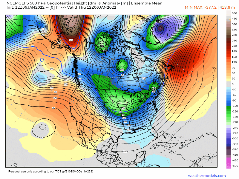
The be frank, the pattern through the next 10 days or so looks like horseshit for snow potential here in the Midwest, outside of LES belts now and later this weekend into early next week. Pacific puke floods the whole country after the Arctic blast early next week. But, the ensembles are in pretty remarkable agreement for so far out in retrograding the ridging after mid-month as the Pacific jet backs off a bit, putting it just off the West Coast and building it towards AK. Also signs of a somewhat more active sub-tropical jet too. With a neutral to even positive NAO and ridge just off the West Coast, it would turn more active in the Midwest somewhere between January 17th and 25th (with some LES possible slightly before it turns more favorable for larger system snows). The GEFS could be colder and maybe give places along and south of the Ohio River a better shot at snow, the Euro may be more of a mid-Mississippi Valley to Great Lakes deal for where it'd be snowiest. Anyways, let's see if this look can move up in time on the ensembles over the next several days. EPS: GFS ensemble:


.png.abbe812c2627b3cb4eddf65bf572625d.png)