
Bubbler86
-
Posts
25,115 -
Joined
-
Last visited
Content Type
Profiles
Blogs
Forums
American Weather
Media Demo
Store
Gallery
Posts posted by Bubbler86
-
-
2 minutes ago, JTrout said:
The Icon shows 2-3 inches of precip over 2/3's of the state with freezing temps. That would be crazy
Here is the snowfall map. These maps are just for posterity sake. If this were to play out many of us would not be on here posting about it since we would be trying to stay warm with no power.

-
Hour 90 of the 18Z Icon is nothing short of an all out Ice Storm. Temps in the mid 20's with Sleet and or FRZA falling. This is after a nice thump of snow.
-
 1
1
-
-
1 minute ago, JTrout said:
Looks like roughly the same idea....
After we got past the GFS I think every other numerical model I have seen has indeed been pushing the SLP through VA (or even more south in the case of the Nam).
-
6 minutes ago, JTrout said:
sorry 6-8", forgot about the thurs night event.
A good thump either way and really interesting question of whether anything gets thrown back as the panels would have gone on. Quite a convoluted scenario. Just about everyone who posts here cashes in. Pitt, Williamsport, PSU in Northern Maryland , even Central MD people.
-
The 18Z NAM is going to cause some to really put their thinking caps on. Brings what I can only describe as a double barrel low in the south east and lower Ohio Valley Saturday afternoon. Initially the northern piece is making a drive for our west but as Nam progresses it centers lower heights on the piece moving through the South East. It ends at 84 with 1022 LP in South Carolina and precip around the Mid Atlantic has lightened up and become scattered. Most here (and N Md) get 6-8" from that first thump waiting to see what the second piece does.
I will add that I can only surmise that the scattered nature of the precip at hour 84 is due to what would be the dry slot from the dying former primary northern low as it scoots south of PA.
-
1
-
-
1 minute ago, Itstrainingtime said:
Trust me, I pay attention to who posts what about what. I was told at a very young age that I'm very perceptive, so there's that too.
Some really good news - reading in the mid-atlantic thread that the EPS is south by about 100 miles for the weekend storm...
EPS takes the storm through central VA.

-
6 minutes ago, Itstrainingtime said:
Some of the names have changed but this still mostly fits:
A Day in the Life of the Central PA Thread
· 12:15am – Blizzard Of 93 shares that the 0z GGEM indicated that all of Central PA looked to pick up over a 1’ of snow in the next 48 hours....
LOL
-
Just now, Itstrainingtime said:
Oh my yes. East Broad Top railroad as well. (I believe it's closed now
 )
)
I'd like a 25 mile shift south from what the Euro output is. That should get everyone in this sub into good snow. We can do this right?
We are going to go out and try to visit the Curve this spring. I like trains but probably not on the same level as you.
I need the shift as well so yes we are going to get it. I identify with the LSV because I have lived much of my life there but technically I am a bit south and west of it so while that EC map has people like Carlisle getting over a foot I am only getting 6-8" so for this specific issue we are in the same boat.
-
3 minutes ago, Itstrainingtime said:
lol I wish! Fact is I love trains. I actually had a year-long membership to the Strasburg Railroad in the past. Some of my vacations are built around riding trains. Cass West Virginia is a favorite trip of mine.
")
So actually I work in HR in employee training and development.
LOL. I figured you meant training people but I chuckled when I saw your first sentence. I am sure you have been to Horseshoe Curve several times.
-
2 minutes ago, Itstrainingtime said:
I'm one of the 4 Mike's. Nut is Erik. And I used to be Maytown but decided on a whim to mix things up and align my name with my occupation PLUS incorporating some weather into it...as in "training" storms.
So you work for a railroad?
-
2 minutes ago, KPITSnow said:
I think that is actually the 1.25-1.5 contour over southern PA.
I hate reading these maps. I literally count contours starting at the dark blue to figure out which is which. It would be great if they didn’t use such similar coloring.
You are right and I did the same thing as you but miscounted the blues. Thanks!
-
Add to the pile of less phased solutions...the JMA. Sends the SE corner of PA above freezing for a bit but still a major winter storm. 1.5 to 1.75 of qpf.


-
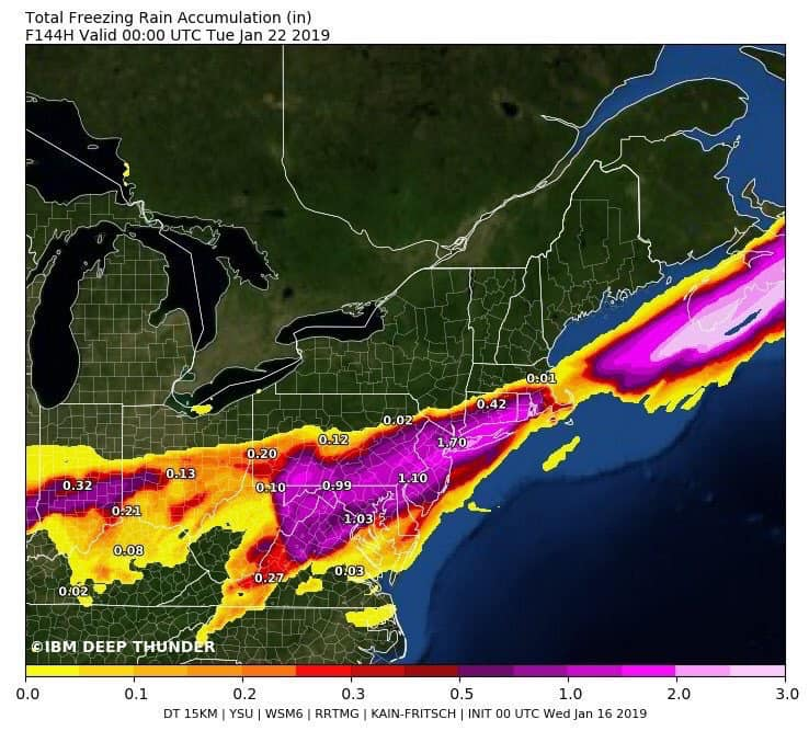
1 minute ago, Cashtown_Coop said:
Can you post the ice accum
Check out deep thunder from the MA thread. No to this.
-
4 minutes ago, daxx said:
I gotta roll guys on vacation with family. I'll be on for late night.
LOL, man you have been great but PLEASE do not stop your vacation for us.
-
1 minute ago, CarlislePaWx said:
Doesn't that look almost exactly like the UKIE map? Wow.
Pitt actually does quite well with that map.
-
4 minutes ago, pasnownut said:
Did anyone take a peek at GEFS and if so what it show. I’m on the road.
The mean is pretty wound up but does go south of us.

-
 1
1
-
-
Just now, daxx said:
Hour 87 nice thump
It is sounding promising. Not driving a low up west of PA.
-
6 minutes ago, KPITSnow said:
I feel like for us in swpa we could just copy and paste this snow map for most storms.
Yea, you guys need a large Miller A. I bet you get screwed by B's all the time.
-
Yoda posted them. Obviously a better ending than the GFS.

-
 1
1
-
-
3 minutes ago, MAG5035 said:
MJO has quietly been forecast to make another round through 4-6, though probably not at the magnitude or longevity of December. I wonder if that may be starting to have an affect on the long range stuff a bit.
And Mag, you are the MJO expert for our forum and others as well so it is always interesting to read your thoughts on it. It is fun (or can be for some) to play the model flipping game some days but the MJO forecasting is hard core Met stuff. In this case if it stays in 4-6 too long it is going to ruin our supposed big hurrah to winter.
-
Working from home this week so have time to scan through for these models...here is an overachiever for Thursday.

-
3 minutes ago, Itstrainingtime said:
It's also once again showing an ugly look at the end of it's run. Hopefully it's wrong.
The site where I am looking at the UK is a bit hard to make out things but it appears to keep the whole column below freezing for the whole state as it pertains to this weekend but a bit hard to read so hopefully someone posts the maps.
-
Just read in the MA forum that the UK is holding tight to it's less phased solution and taking the LP into VA.
-
3 minutes ago, MAG5035 said:
CMC vs GFS at 90hr actually illustrates more of a difference in the thermal column. CMC's low pressure actually a tad further NW than the GFS at that frame but better front end snows. Looks like it has more of an attempt at a secondary coastal low too.
My experience with these types of storms is typically that reality ends up being a bigger fight on p-type transition in the central counties and sometimes the LSV.. especially when theres a good frozen front end and some high pressure above us. Surface-925mb temps aren't easily routed in the ridge and valley region of central PA. This type of track suggests to me a potentially more extended period of icing in the AOO-UNV corridor and between I-80 & I-78 and west of I-81 in the Sus Valley. And I'm talking the track that the 12z guidance is putting up so far. But these regional tendencies don't typically show up on the global ops til pretty late in the game.
With said regional tendencies in mind, this is the range and situation right now where using ensemble blends and putting more weight on those ops supportive of the general consensus via ensembles is probably the best move to get a rough idea on possible impacts.
I also suspect that whatever is depicted on any given model, the surface temps of many posters here will struggle to turn this into plan rain (except the situation where the low goes west of PA...then we are into the 50's). Regardless of what trends show the word is that PA is in for a complicated winter storm. If you have read a few of my many posts the last few days you may have noticed I am hoping for a more snowy solution vs. trying to hold on to FRZA with 1/4" an hour rain rates so some of my posts are slanted that way.
And yea on the CMC I noticed it was quite west but the 540 line stopped advancing between 90 and 96 when the coastal started to influence the situation.


Central PA - Winter 2018-19
in Upstate New York/Pennsylvania
Posted
We are moving toward the relatively rare 'Double Winter Advisory. We would have an active WWA for Thursday night at the same time as an active WSW for Saturday.