

Bubbler86
-
Posts
25,310 -
Joined
-
Last visited
Content Type
Profiles
Blogs
Forums
American Weather
Media Demo
Store
Gallery
Posts posted by Bubbler86
-
-
5 minutes ago, lpaschall said:
I presume if it decouples the solution would come in colder?
Yea, my premise/hope for snows here would be less phasing and the southern Vort taking over sooner which would stop the massive influx of southerly winds.
-
End result I think for most of LSV is 3-6" of snow then slop...possibly even rain. Whole LSV goes above freezing verbatim but much of the precip is gone as we dry slot.
-
It is trying to transfer/decouple. Panel 39 it focuses on the southern vort then back to the northern vort the next panel. Still think it is indeed a tad warmer overall.
-
Storm also appears faster which can play games with comparing panels.
-
Still looks like it is trying to go below us. Most still frozen well into the event. Snowfall map is going to be juicy but again this TT map will include sleet.
-
Starts snowing in earnest Saturday afternoon.
-
1 minute ago, Itstrainingtime said:
That Ralph Wiggum guy says the NAM is north and warm to whatever panel he's at.
Its only out to 27 on TT and it is way north but could still transfer.
-
Just now, anotherman said:
I think he means the amount of snow everyone just got.
LOL, funny as the Euro map is also close to the numbers.
-
6 minutes ago, Wmsptwx said:
It looks like 1.4 to 1.6 over good part of state?
If mentioning this for the Euro map....a lot of that is rain down here.
-
1 minute ago, Itstrainingtime said:
I know the Euro can tend to run a little dry BUT it does seem like this storm has been slowly moving away from the huge QPF bomb of a few days ago.
It has been much faster on the NAM, GFS and ICON. Finishing up earlier Sunday AM (later for you).
-
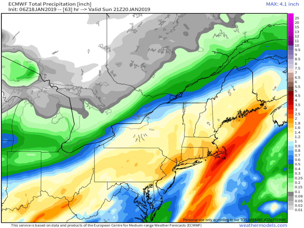
5 minutes ago, Voyager said:
I've yet to figure out where to get and see the 6z/18z Euro output. What sites have it?
Mostly paid sites but I saw it on another forum. Here is what I saw below. You can tell it is way north by the dry slot coming up toward southern PA.
-
 1
1
-
-
11 minutes ago, Itstrainingtime said:
Yeah. I think really the big question on tap for us is just how long we hold onto frozen before changing to plain rain.
Hopefully the 6Z Euro is not the trend. Going to need the Euro to bust on this one.
-
Just now, Itstrainingtime said:
Yep, my work is 12 miles south of where I live and it was 29 here.
Going to get me this weekend. Based off how it looks now I would only expect 1-3" before change over. Euro seems like a plan rain storm. Need that low to transfer earlier!
-
Just now, Itstrainingtime said:
I had 26 when i left for work at 4:30am.
I am the most southern member of the forum so probably some temps differences.
-
Not very cold out this AM. 31 here. Snow compaction last night makes it hard to measure but guess 1.5 with snizzle falling right now.
-
Good Morning...
Scanned a few models and all looks the same as last night.....status quo for big snow thump on the colder models, EURO, FVS and RGEM get us into the 50's.
-
One more map. The Baby GFS. an I81 special. Screws me but also screws Cashtown so throw that impossible garbage out. We bought this house knowing we would be getting cashtown like ratios.

-
 1
1
-
-
Just now, CarlislePaWx said:
Just took my midnight reading for snowfall and I'm now up to 1.3" with light snow falling. I guess there really is a shot of reaching 2.0" by morning looking at the fairly full radar to the west. Not bad. Temp not budging from 27.1 degrees.
I think most schools are delaying two hours so the storm did its deed. This 1-2 snow has been consistently called on everything, except the hdprs, for a week now so lets give some credit to the short rangers. The hate I see for the Nam is so misguided at times as well. I do not want to go into any split model battle with the Nam against me.
-
UK maybe a tad south. This would still be a big mix in LSV.

-
Not so sure a solution shown by the NAVGEM, just not as extreme, should be totally disregarded at this point. That is not necessarily good for us as it could be weaker and south but the Nam and Icon have been toying around with the early transfer idea for a couple days now. If we had true arctic air in place, not just lingering near the US border, this thing would probably be bouncing down to Florida at this point and we would be praying for a phase instead of against it.
Edit-The idea here is little to no phase just a juicy area of qpf traversing the mid and south US. Highly unlikely at this close of a range but no phase is no phase...
-
So it is snowing right now, probably going to snow again in 48 hours...cannot possibly again next week, can it? Front stalls after the early week cutter and this...

-
Just now, JTrout said:
Cmc colder, further south, not great but close for us on th fringe.
CMC snow map. Again use with caution as there is mixing in the LSV.

-
1 minute ago, pasnownut said:
look at last 3 runs, and you can see the SE progression, albeit slight, its there. 2 more ticks, and BOOM. We still have time good/bad for that to happen.
I do not want to step on any Met's toes but would it surprise anyone at this point if that northern vort really did minor out and the southern vort takes over even farther south than the Nam or GFS show it. Definitely a convoluted situation.
-
5 minutes ago, paweather said:
GFS = sorry. You can look at Canada and it is writing on the wall.
GFS is somewhat similar to icon's progression. All 3 0Z runs so far are not far off on their low placements. Playing into bias the NAM is extra juiced like usual.
Central PA - Winter 2018-19
in Upstate New York/Pennsylvania
Posted
Its eventually goes with the southern vort taking it off the SE VA coast but like so many other runs the damage has already been done for our temps by that point. Snow map looks great but Kuchera will not look nearly as good.