frd
-
Posts
6,934 -
Joined
-
Last visited
Content Type
Profiles
Blogs
Forums
American Weather
Media Demo
Store
Gallery
Everything posted by frd
-
I get it, but December was the coldest December since 2010, had snow showers, snow squall, decent snow event here, measured 4.5 inches. The coldest and snowiest part of the winter may still be ahead.
-
Complex pattern, more clarity by the weekend. Looking forward to the afternoon EPS.
-
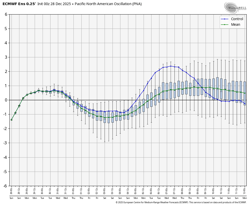
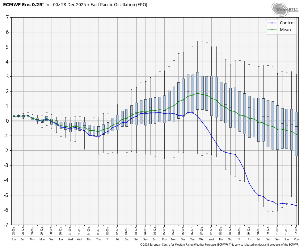
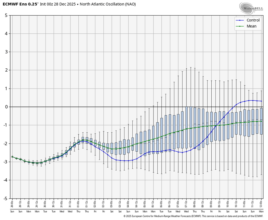
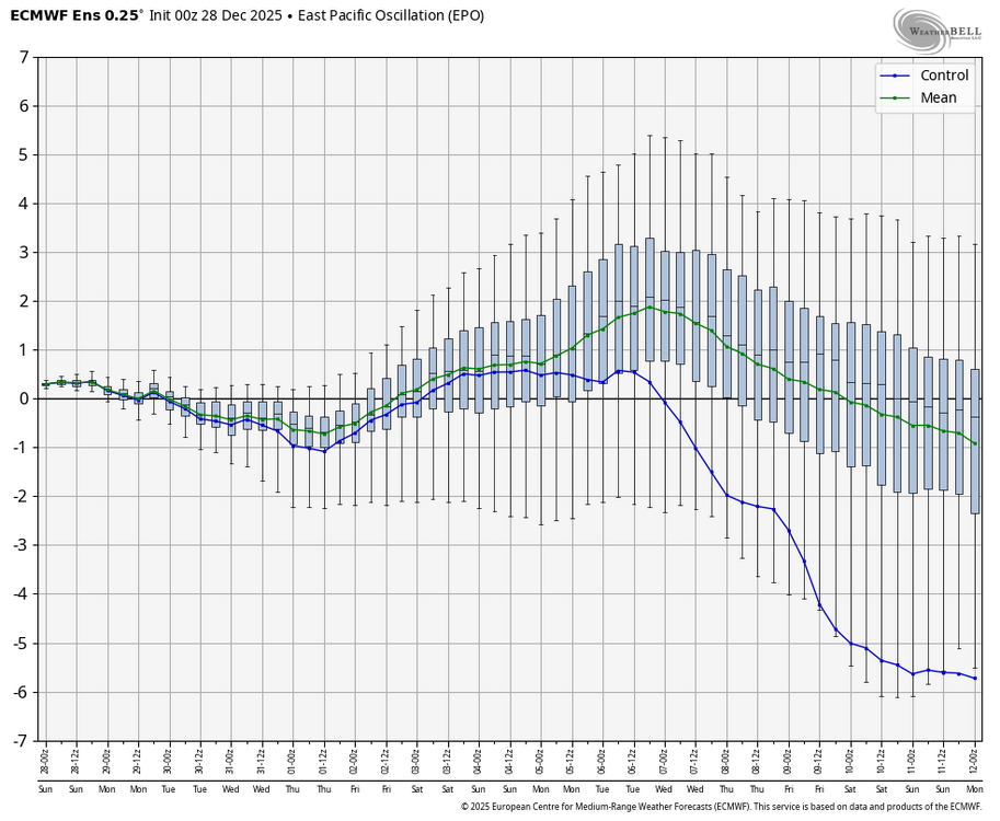
Just reflecting on the improvement in the PNA region however once the negative EPO arrives I agree we do not want an overly positive PNA. As @CAPE has mentioned we have done well with small to medium events during previous winters which featured a negative EPO pattern. There's no reason to think we cannot take advantage of this time period later in the month for snowfall opportunities. What is also encouraging to know is that the polar vortex is not likely to strengthen significantly and even though the Arctic oscillation is forecast to rise from standard deviations of -3 it will likely head back down again according to the models
-
General concensus is still up with the PNA as of today's update.
-
The ECMWF AIFS Ens I heard are doing well. This shows we are back in business by the 15th. GEFS AI at the very bottom.
-
Wow that was awesome. Winds to at least 35 with crazy snowfall rates. Came in like a freight train. Worth getting up for. Heaviest snow I have seen in a long time.
-
Same here.
-
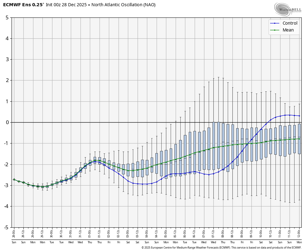
We have seen this before as well. The - NAO linking with the WAR, likely due to the SE ridge/WAR becoming more prominent due to the reaction from the Pac jet extension.
-
The Pac jet extension is a bit too robust leading to the warm up. There is a ton of heat energy in the Western and SW Pac. The warm up was actually spoken about about 10 days ago, ( although some thought it would not happen since other warm ups have trended less and less over time ) however this time it appears likely it will be warming up ahead of the - EPO/ +TNH pattern. Goes to show you the Pac is King, the current - NAO and the - AO are useless when the Pac does not cooperate.
-
Oh my
-
It would be awesome ! I like how all three major ensembles are showing this happening, leading to more confidence going forward.
-
This period has the best overall potential if you favor powder events with snow on snow. Hopefully this becomes reality in a couple weeks. Maybe we even get a true deep winter feel with both cold and snow. Bring it !
-
You see a more active Southern stream?
-
In this day and age, I will gladly take any snowfall and be happy. I am not getting any younger. LOL However snowfall brings the kid out in me.
-
Digital cocaine. Snort this all day. Miami Vice meets the Cold Miser - happy hour was awesome !!!! Hey this snow porn should not be posted, but the take away is finally the pinks have arrived and the snow reaches SC. A good sign.
-
Looks nice. The Greenland block is moving WSW by early Jan. As for specifics, just be happy we have a chance to score in the coming weeks.
-
Tomer Burg @burgwx Very much in alignment here - not sure exactly when things fully kick off but once they do I suspect we'll have at least a 2-3 week window more favorable for moderate-major snowstorms vs. climo. South of NYC is likely more favored than north of NYC given Greenland block climo, but too soon to specifically rule NYC nor anyone else out. 12:21 PM · Dec 28, 2025 · 1,663 Views
-
Vortex in SE Canada at that point, and goes well with the forecasting of the elongation of the PV near early Jan. Hopefully not as squashed as time moves on. We failed last year, or the year before in a similar fashion. Here is a 3 D vortex image, a bit outdated, but shows it pressing Southward.
-
Tomer Burg @burgwx · 1h What does this mean for snowstorm prospects in the East Coast? Initially, not much. Notice how we start with the same cold and dry NW flow regime we've been in before. The key is to monitor the upstream evolution, as the Bering Sea block erodes and is likely replaced by a Pacific trough, increasing the chances of western US ridge amplification. The kind of pattern increases the probability of a moderate to major snowstorm vs. climatology in the Mid Atlantic, and potentially southern New England, which would necessitate a well-timed upstream ridge amplification coinciding with downstream confluent flow and a sufficiently cold airmass in the northeast US. While a major snowstorm is never a guarantee, chances of at least one or two in the January 8-25 time frame are higher than average
-
Tomer stated the following today, " While a major snowstorm is never a guarantee, chances of at least one or two in the January 8-25 time frame are higher than average. "
-
-
Tony Pann @TonyPannWBAL Go Time??? I have to admit; the weather alphabet is looking good for the chance at a coastal snowstorm going into the first few weeks of the New Year. +PNA, -EPO, -NAO. Does that mean Baltimore will finally get a Monster Snow for sure? No, of course not. But the table is set. Stay tuned...
-
Seems very reasonable, but keep expections tempered for now until we get closer in.
-
Allan talks about the transition period and how the pattern may evolve going forward. There seems to be more concensus about a mid month warm-up ahead of the improving Pac. We shall see. Allan Huffman @RaleighWx · 1h 1) As others have posted today, this look around 1/7 could be conducive to a potential East Coast winter storm. A west-based -NAO, a deep trough axis along the East Coast. We do lack a western NA ridge to really push cold air south though. If we can get a s/w to drop into the Deep South/TN Valley far enough SW it could help pop a low near the SE/mid-Atlantic coast. Certainly no guarantee but the chance is there. 2) I do think in general the period between 1/5 and 1/15 or so will see a transition to the overall long wave pattern. On today's 12z EPS, notice we see a ridge over Central Asia, a trough into east Asia and a ridge builds downstream over western North America. We could even see perhaps a Kona Low go into Hawaii which would re-enforce potential blocking ridging over the NE Pacific and provide an active subtropical jet stream. I do think this goes to a solid -EPO by mid-month. Show more Allan Huffman @RaleighWx 3) However in this transition period say day 12-17 or so, we could see milder temps for a few days across much of NA as the cross-polar flow temporarily shuts off. The west-based-NAO though may keep the Lakes/East normal or a little below normal. But our source region in Canada will warmup and will need some time to replenish the cold air via cross-polar flow. 4)Todays EC46 shows how this could play out and by weeks 3/4 we see a cold looking pattern with cross-polar flow, a -EPO/-AO/-NAO look and the cold air replenished in Canada. This would take us into late January. So I do think the 2nd half of January look promising for cold/snow in the East. We shall see!
-
BAM Weather @bam_weather · 1h The type of set-up into the second week of January won't be one that favors major arctic cold, but can offer up increased winter storm potential for the East Coast. No signs of this strong -NAO set up breaking down any time soon. Top analogs into January based on the Polar Vortex and Tropical Forcing also support the idea of a favorable set-up for snow in the lower OH/TN Valley regions and the Mid-Atlantic. Eventually as convection once again traverses the equatorial Pacific Ocean, we should see the Alaskan ridge (-EPO) rebuild and allow for a more widespread/consistent shot of cold air across the US mid-late January. The EPS Weekly is already hinting at this idea. Stay up to date with our Energy Reports on the pattern ahead here: https://bamwx.com/register/energy-commercial/