

frd
-
Posts
6,996 -
Joined
-
Last visited
Content Type
Profiles
Blogs
Forums
American Weather
Media Demo
Store
Gallery
Everything posted by frd
-
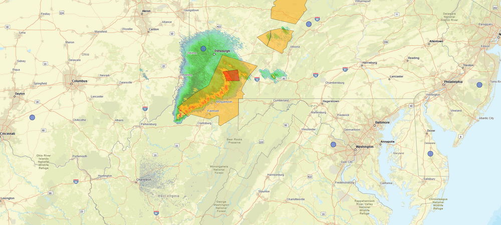
I hope machine learning ( which is very bullish) regarding severe weather is somewhat accurate. See below: Upper level ridging is expected to build overhead on Thursday, with several models also showing a shortwave disturbance passing through the top of the ridge. How this disturbance evolves will have a large impact on our forecast locally. If the disturbance passes through early in the day, we could have large scale subsidence and relatively low coverage of showers and thunderstorms. If it were to approach at peak heating, we could have a much greater coverage of thunderstorms. Upstream convection will likely have a large impact on how that disturbance evolves, so confidence in the forecast details on Thursday is lower than normal. What models are in good agreement about, is that the background environment will be highly unstable (CAPE values likely in excess of 3000 J/kg). There will also be enough dry air in the mid-levels to support strong downdrafts (DCAPE in excess of 1000 J/kg), and just enough shear (around 20 kt) to give storms some weak organization. Such an environmental setup is common in many of our more impactful summer severe thunderstorm events. As a result, there appears to be a conditional threat for severe thunderstorms on Thursday. That threat for severe thunderstorms may continue on Friday as a shortwave disturbance passes to our northwest through the Great Lakes causing the upper ridge to break down and a surface cold front to approach from the northwest. With greater synoptic scale forcing, confidence in the occurrence of storms is higher on Friday, but instability might be slightly lesser. Machine learning guidance is very bullish on the severe thunderstorms threat for both Thursday and Friday. We will continue to monitor this potential threat over the upcoming days.
- 444 replies
-
- 2
-

-
- severe
- thunderstorms
- (and 7 more)
-
Later this week, and next week appears to get more active as the general pattern begins to change. Increasing chances of storms every couple days once we get to this Wednesday.
- 148 replies
-
- 2
-
-
- we got burned
- rugpull central
- (and 1 more)
-
Huge dive in the SOI Date Tahiti (hPa) Darwin (hPa) Daily Contribution 30 day Av. SOI 90 day Av. SOI 7 Jun 2026 1014.05 1017.70 -34.73 -19.19 -9.71 6 Jun 2026 1013.94 1016.55 -27.42 -18.06 -9.05 5 Jun 2026 1012.20 1015.15 -29.81 -17.33 -8.44 4 Jun 2026 1010.52 1014.25 -35.29 -16.43 -7.77 3 Jun 2026 1010.14 1013.80 -34.80 -15.47 -7.10 2 Jun 2026 1012.48 1015.05 -27.13 -14.79 -6.56 1 Jun 2026 1013.74 1014.85 -16.87 -14.14 -6.04 31 May 2026 1013.79 1014.20 -14.84 -13.58 -5.64 30 May 2026 1012.24 1014.15 -26.33 -13.17 -5.29 29 May 2026 1011.31 1014.15 -33.46 -12.63 -4.77
- 148 replies
-
- 1
-
-
- we got burned
- rugpull central
- (and 1 more)
-
Clouds dropping SE
-
Southern portion of the line appears to be weakening.
-
That would be a bummer. Dew point creeping up here to 60. Have not looked at the severe paramenters though for later.
-
Rather strong complex
-
Might sneak into my area. Fingers crossed.
-
Philly news tonight with voluntary restrictions in certain areas.
-
F ing Omen title. Has brought nothing but bad luck, bad timing and zero rain.
-
We are cooked
-
Accuweather disagrees with multi days of clouds and rain https://www.accuweather.com/en/us/middletown/19709/10-day-weather-forecast/2218503?page={page} The Weather Channel has mid to at times upper 80's Wed 10 84° / 63° Mostly Sunny Thu 11 88° / 68° Partly Cloudy Fri 12 89° / 68° Partly Sunny Sat 13 87° / 66° Partly Cloudy Sun 14 86° / 69° Partly Cloudy Mon 15 86° / 69° Partly Cloudy Tue 16 86° / 69° Partly Cloudy Wed 17 83° / 67° Mostly Sunny Mount Holly only goes to next Weds. Not nearly as warm as the Weather Channel Monday Mostly sunny, with a high near 73. Monday Night Partly cloudy, with a low around 56. Tuesday Mostly sunny, with a high near 76. Tuesday Night Partly cloudy, with a low around 58. Wednesday Mostly sunny, with a high near 81.
-
Warmest weather relative to seasonal averages in June and early July, then we trend down in later July and August. Wishful thinking, or possible outcome with the El Nino coupling faster than expected.
-
Looking beyond days 8 to 14
- 148 replies
-
- 1
-
-
- we got burned
- rugpull central
- (and 1 more)
-
I even take normal.
-
https://x.com/webberweather/status/2061163954496237618 Eric Webb @webberweather This is probably the biggest Pacific Jet extension I’ve ever seen in June & it isn’t surprising to see as we discussed several days ago. Buckle up… Eric Webb @webberweather All the ingredients are there for a gigantic Pacific Jet extension later in week 2 & 3, which should lead to a more favorable pattern for tornadoes by mid-June: Kara Sea ridge >> East Asia cold shot Mei-Yu front south of Japan Pacific MJO event Developing Super El Niño
-
More active pattern as we near mid-June possibly.
- 148 replies
-
- 1
-

-
- we got burned
- rugpull central
- (and 1 more)
-
-
Have to bag mine. It's very tall 6 inches. Might even have some dollar spot. Been so moist and cloudy. Will cut it tomorrow as the soil should be firmer and dew point even lower.
-
Crazy Omega block. Canadian wildlife potential, but nice here, can't wait !
-
-
crazy waves https://northwildwood.com/north-wildwood-surf-cams/
-
-
-
Any thoughts about June turning the corner with more rainfall via the WAR.
