

Rjay
-
Posts
28,400 -
Joined
-
Last visited
Content Type
Profiles
Blogs
Forums
American Weather
Media Demo
Store
Gallery
Everything posted by Rjay
-
Imagine someone asking what the 18z Metsfan shows
- 511 replies
-
- 8
-

-

-
- heavy rain
- tropical gusts
- (and 1 more)
-
That's not a real model. It's the metsfan of models. Or maybe that's the Cras *shrug*.
- 511 replies
-
- 2
-
-
-
- heavy rain
- tropical gusts
- (and 1 more)
-
I meant to post the 0z and 6z. 6z NAM
.thumb.png.9f786b7cf77b3b407e591832fedf0488.png)
-
Canadian models are south. Ukie and gfs are in the middle. The Euro and NAM are north.
- 511 replies
-
- 2
-

-
- heavy rain
- tropical gusts
- (and 1 more)
-
Tracking The 3”+ Heavy Rainfall Events Since 2010
Rjay replied to bluewave's topic in New York City Metro
It's a shame I can't find other totals. There's no way that was the highest or even close. -
Record Number of Extreme 10”+ Rainfall Months Since 2003
Rjay replied to bluewave's topic in New York City Metro
Didn't almost all of Islip's 14.07" of rain in August 2014 fall in 2.5 hours? 13"+ right? -
Of course you are. You don't read.
-
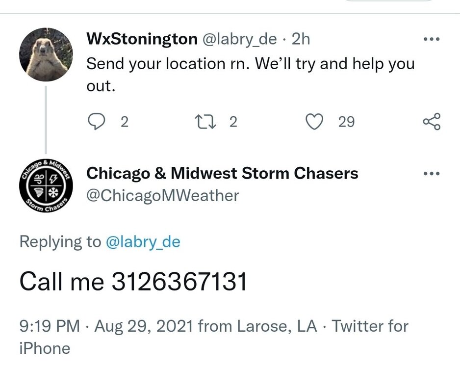
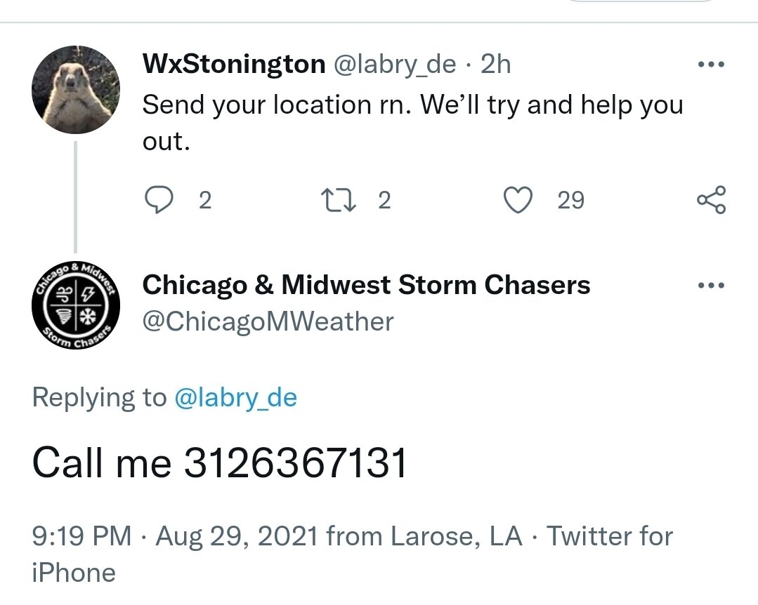
1048 PM CDT Sun Aug 29 2021 ...FLASH FLOOD EMERGENCY FOR LAFITTE AND JEAN LAFITTE... The National Weather Service in New Orleans has issued a * Flash Flood Warning for... Central Jefferson Parish in southeastern Louisiana... * Until 645 AM CDT Monday. * At 1048 PM CDT, local law enforcement reported levee failing around Lafitte and Jean Lafitte. Over 200 people in imminent danger This is a FLASH FLOOD EMERGENCY for Lafitte and Jean Lafitte. This is a PARTICULARLY DANGEROUS SITUATION. SEEK HIGHER GROUND NOW! HAZARD...Life threatening flash flooding. Heavy rain and surge are leading to a failure of the levee. SOURCE...Law enforcement reported. IMPACT...This is a PARTICULARLY DANGEROUS SITUATION. SEEK HIGHER GROUND NOW! Life threatening flash flooding of low water crossings, small creeks and streams, urban areas, highways, streets and underpasses.
-
Tell him yourself
-
Always wrong about everything. Congrats bud.
-
And he tweeted that 18 hours ago lol.
-
Hopefully
-
Disagree
-
6mb in 1 hour is impressive
-
It should but obviously will still be really bad. 10-15' instead of 15-20'+ but the former is what is forecasted anyway at this time.
.png.bba4646feddd229c00eae18705073ac8.png)
.png.c9a6f2f45ce23133d722c6d6ce9e29cb.png)
.png.901f84edb50e06ff4f4cf9084dbae913.png)
.png.af3bc41871ed2643874e39de193e391d.png)
.png.ec31de15a2657876d94da26d5a1df461.png)
.png.f45729281aa7ed7f0b714eb746116ed2.png)
.png.9d3a8ab49c298d9bc9958df2c1c7b00b.png)
.png.3747a46d5d80610797bba198bc333fb6.png)
.png.0aedc20a12823fbe36d7cf4b8019a5ec.png)
.png.82e69bdb9fcac14cba4a6d6d0d615cea.png)
.png.cfd825eb4889e9b77ac0cc5373e55542.png)
.png.e159ea787d9bb73cda6fc1874b43e9b5.png)
.png.3c4b14ccf868438159f112ae4698d68d.png)
.png.0036af62b304b1981f24de744ea4316b.png)
.png.b00c3db2b52669cd502ca8c8c9dbcd01.png)
.png.f35803e79deca52bbd0de219c623c438.png)
.png.b7f6ddf4e872a329e9c78ad24801fe34.png)
.png.98224beddd739d0f89c4d785ddeea1c6.png)