WxUSAF
-
Posts
28,422 -
Joined
-
Last visited
Content Type
Profiles
Blogs
Forums
American Weather
Media Demo
Store
Gallery
Everything posted by WxUSAF
-

12/12: The little Friday clipper that could? Or won't.
WxUSAF replied to dailylurker's topic in Mid Atlantic
Gonna ignore the white dot over my house -
Uh, well it Fs us both pretty badly, but other people cash in
-
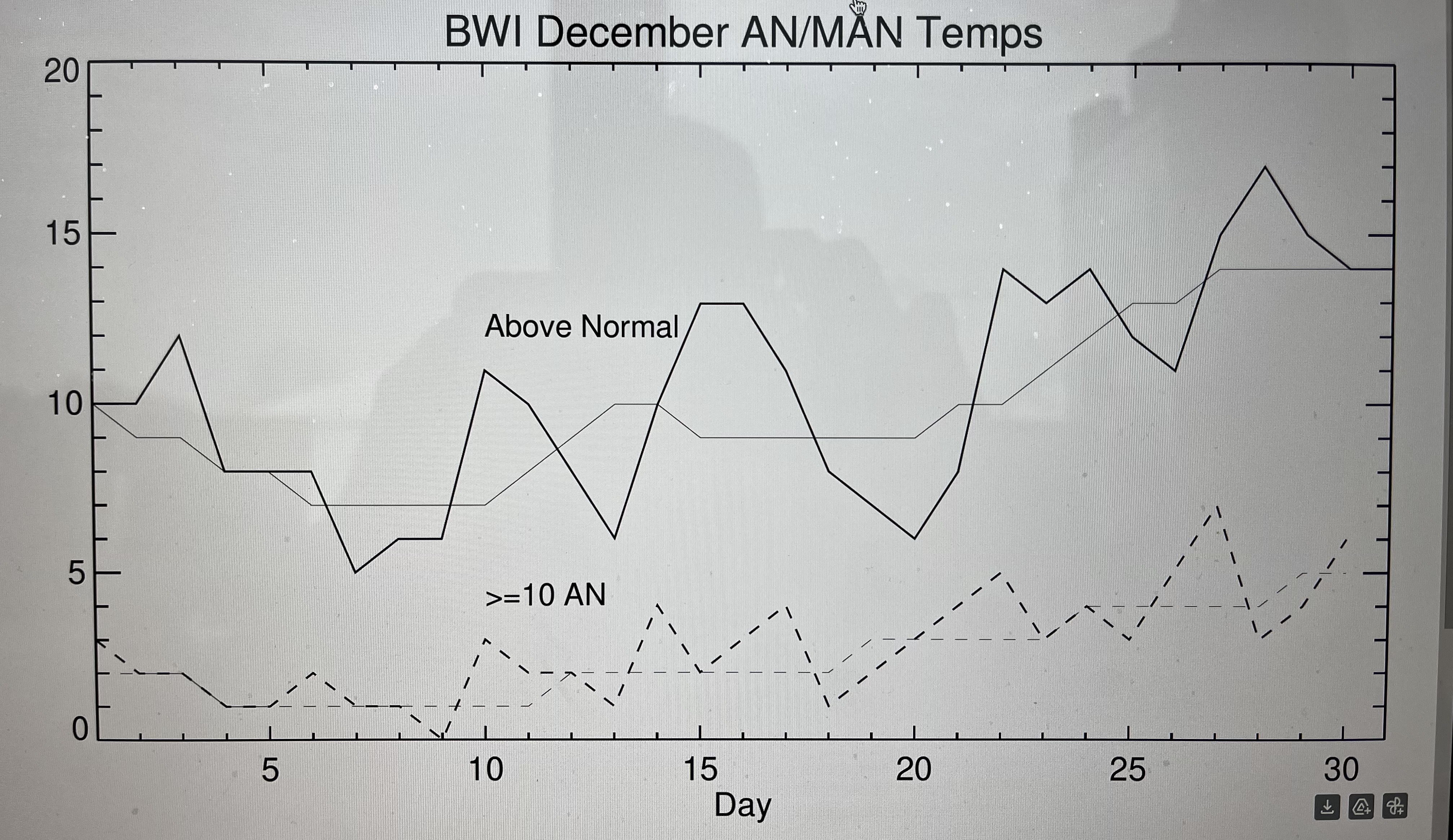
With potentially another Xmas torch staring us in the face, I decided to make a plot to see if it’s been as real as it feels or has been for years. So this plot is BWI above normal and much above normal (>=10F) occurrences from 2005-2024. Thicker lines are the year by year counts for each calendar day and thin lines are smoothed by 7 days. Short answer is yes…and the week after Xmas before new years has been the most torch prone.
-
The warm pool moving eastward would be a good thing for us. Basically puts the background conditions to support the strongest convection (essentially the MJO) in a more favorable position for eastern troughing.
- 827 replies
-
- 13
-

-

-
Last Friday's storm almost disappeared for DC-north within 36 hours? So I don't expect much consistency on a weak vort in fast flow until like 0z Thursday.
-
Just seems weak based on precip. Doesn’t give anybody a ton of love.
-
EPS likes Friday more than Sunday.
-
Euro AI is nothing for Friday outside the mountains. Sunday leans north of us, but dusting for DC, 1” for Baltimore, near 2” along M/D line
-
There it is on 12z gfs. Which is more inevitable? Thanos or Torchmas?
-
GGEM follows icon and Fs us twice
-
Gfs Friday clipper looks great and then falls the F apart, but not before giving VA some much deserved snow!
-
-
Sort of similar to GEPS, but better over the pole. That’s a gradient look, but obviously a lot of cold air available to tap. Not shut the blinds.
-
And 6z GEFS completely flips to se ridge
-
The torch/SE ridge progs have stayed firmly beyond D10 for weeks now. Maybe this one is different but I want to see it inside of D7 first before I buy it. Persistent MJO phase 8 argue against it.
-
12-14 as the low depending on which PWS I look at.
-
Would it even be the Christmas season without some days in the 60s!?!
-
Big divergence in ensembles toward Xmas. GEFS keeps an eastern trough although the western ridge pushes the trough axis over us and even offshore for a time. EPS goes full SE ridge with a deep western trough developing. Geps somewhat in between but leaning more toward EPS.
-
-
There were some changes at 500 that I liked actually. Looked like it almost phased in some more energy up in Canada. I think it was pretty close to a bigger event.
-
For reference, it’s colder than 0z, but still has AN temps most of that week. Just keeps the ridge axis more in the center of the country vs over us. But maybe a step toward again muting west coast troughing and an east coast warmup.
-
12z eps with notable colder shift in second week vs 0z
-
Bases on the euro’s depiction, it’s pretty clear how only 1 of the 2 can really work out. The shortwaves are just close together. So a stronger Sunday shortwave prevents Friday from amplifying. Confluence on 12z is actually better than 0z for Friday.
-
Dew points really crashing up here in frozen mud land
-
We got some time unlike whatever small north trend happened on today’s VA storm