

dan11295
-
Posts
3,193 -
Joined
-
Last visited
Content Type
Profiles
Blogs
Forums
American Weather
Media Demo
Store
Gallery
Everything posted by dan11295
-
Major Hurricane Melissa - 892mb - 185mph Jamaica landfall
dan11295 replied to GaWx's topic in Tropical Headquarters
Looks like Melissa really trying to hug the coastline for a bit prior to finally being pulled inland. -
Major Hurricane Melissa - 892mb - 185mph Jamaica landfall
dan11295 replied to GaWx's topic in Tropical Headquarters
Based on Pilon, Cuba radar eyewall probably coming ashore in next 45-60 minutes -
Major Hurricane Melissa - 892mb - 185mph Jamaica landfall
dan11295 replied to GaWx's topic in Tropical Headquarters
Last dropsondes suggests Melissa has peaked/leveled off with the 895 mb 7 kt. Not going to matter much at this point though as far as Jamaica goes. This is basically going to be landfall intensity. -
Major Hurricane Melissa - 892mb - 185mph Jamaica landfall
dan11295 replied to GaWx's topic in Tropical Headquarters
Seeing that dropsonde on a storm 2-3 hours from landfall is terrifying. -
Major Hurricane Melissa - 892mb - 185mph Jamaica landfall
dan11295 replied to GaWx's topic in Tropical Headquarters
Can't imagine the wind gusts that will occur at elevated locations with this storm. Fortunately a lot of buildings there are concrete block at least. -
Major Hurricane Melissa - 892mb - 185mph Jamaica landfall
dan11295 replied to GaWx's topic in Tropical Headquarters
I wonder if Melissa had a slight rise in pressure during the eyewall meld, and is now steady state or slightly intensifying again. Almost certainly not weakening at the moment. -
Major Hurricane Melissa - 892mb - 185mph Jamaica landfall
dan11295 replied to GaWx's topic in Tropical Headquarters
#9 all time in Atlantic Basin by pressure -
Major Hurricane Melissa - 892mb - 185mph Jamaica landfall
dan11295 replied to GaWx's topic in Tropical Headquarters
Just a reminder that late season storms can show colder cloud tops than normal especially at night compared to earlier season storms. Not that Melissa isn't an intense hurricane, which it is. -
Major Hurricane Melissa - 892mb - 185mph Jamaica landfall
dan11295 replied to GaWx's topic in Tropical Headquarters
11230 1632N 07836W 6972 02308 9028 +223 +126 025015 020 016 002 00 902.8 mb extrap Wonder if thats a bit low though. -
Major Hurricane Melissa - 892mb - 185mph Jamaica landfall
dan11295 replied to GaWx's topic in Tropical Headquarters
Look at the radar. heavy rain has been pounding most the island for the past 6 hours. Precip echos surrounding the eye seemed a bit less intense on the radar loop during the last 2-3 hours. Don't know if there is some attenuation involved since Melissa obviously still has great IR presentation. Not sure how long we will have access to radar once the storm moves closer.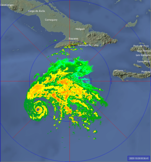
-
Major Hurricane Melissa - 892mb - 185mph Jamaica landfall
dan11295 replied to GaWx's topic in Tropical Headquarters
Melissa is expected to turn due North then Northeast very shortly. would take a large very short term modeling error to miss the island sadly. -
Major Hurricane Melissa - 892mb - 185mph Jamaica landfall
dan11295 replied to GaWx's topic in Tropical Headquarters
12Z HAFS-A keeps Melissa basically steady state until a 907mb 16z landfall just west of Treasure Beach. HAFS-B has 901 mb landfall a bit tad further west about 13z -
Major Hurricane Melissa - 892mb - 185mph Jamaica landfall
dan11295 replied to GaWx's topic in Tropical Headquarters
6z HAFS-A model which has handled Melissa very well intensity and movement wise, bottoms out of 906 mb between 6-9z Tuesday with 913 mb at landfall West movement has ceased on satellite. Based on all the models and forecast, the north turn should be imminent. -
Major Hurricane Melissa - 892mb - 185mph Jamaica landfall
dan11295 replied to GaWx's topic in Tropical Headquarters
Only positive is that Melissa might be far enough west to keep Kingston area out of the eyewall winds and the south coast of Jamaica isn't that surge prone. Biggest threat has been and continues to be the flooding as hazwoper just mentioned. Farther west track unfortunately subjects more of the island to very high rainfall totals and the NNE trajectory is unfortunately very favorable to squeezing out the moisture via orographic lifting. -
Major Hurricane Melissa - 892mb - 185mph Jamaica landfall
dan11295 replied to GaWx's topic in Tropical Headquarters
It appears NHC overshot the actual winds and pressure drop with the 5 am advisory. But I understand operationally why they would not want to drop the winds, which could imply a weakening system. They obviously do not want anyone to start letting their guard down with the main rain shield now very close to reaching Jamaica. -
Major Hurricane Melissa - 892mb - 185mph Jamaica landfall
dan11295 replied to GaWx's topic in Tropical Headquarters
Eye continuing to clear on IR, suggesting intensification is continuing. -
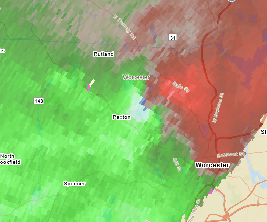
looks to be still some rotation with the Holden cell. Going to come really close to here so definitely watching it.
-
This was at 402 pm when it looked to be the strongest
-
there was a decent couplet for like one frame on the radar, doesn't look like much now though.
-
July 2025 Obs/Disco ... possible historic month for heat
dan11295 replied to Typhoon Tip's topic in New England
EWR hit 100 again what else is new, just checked that's 7 days of 100+ this year. -
July 2025 Obs/Disco ... possible historic month for heat
dan11295 replied to Typhoon Tip's topic in New England
gauges (from WunderMap) -
July 2025 Obs/Disco ... possible historic month for heat
dan11295 replied to Typhoon Tip's topic in New England
Seeing multiple rain gauges with >5" now. -
OWD 100 at 1 pm other 100+ obs at 1pm EWR 100 JFK 102
-
Stuff is ramping up very quickly now, significant TDS showing on radar from multiple tornadoes currently.
-
Kind of crazy that Pensacola is going to have a bigger snow event than Boston has has in 2+ winters


