GrandmasterB
-
Posts
805 -
Joined
-
Last visited
Content Type
Profiles
Blogs
Forums
American Weather
Media Demo
Store
Gallery
Everything posted by GrandmasterB
-

Central PA Autumn 2024
GrandmasterB replied to Itstrainingtime's topic in Upstate New York/Pennsylvania
Looks pretty much like the Euro. Voyager in a good spot. -
Central PA Autumn 2024
GrandmasterB replied to Itstrainingtime's topic in Upstate New York/Pennsylvania
Incoming on the NAM -
Central PA Autumn 2024
GrandmasterB replied to Itstrainingtime's topic in Upstate New York/Pennsylvania
12Z Euro snowier than 0Z. Northern Lebanon on north does well verbatim. Light accums all the way down to MD border. I can’t believe I’m saying that on Nov 20 after these crappy winters. Huge W! -
Central PA Autumn 2024
GrandmasterB replied to Itstrainingtime's topic in Upstate New York/Pennsylvania
-
Central PA Autumn 2024
GrandmasterB replied to Itstrainingtime's topic in Upstate New York/Pennsylvania
No RGEM clown map? I’ll give ya’ll a break because it’s early in the season, but we need to step up the weenie game. -
Central PA Autumn 2024
GrandmasterB replied to Itstrainingtime's topic in Upstate New York/Pennsylvania
Drenched in sweat raking leaves, garden remains productive, 80 degrees in the house. Quite a late fall you guys are running here. -
Central Pa. Summer 2024
GrandmasterB replied to mahantango#1's topic in Upstate New York/Pennsylvania
Pretty decent size hail just a few minutes ago. -
Central Pa. Summer 2024
GrandmasterB replied to mahantango#1's topic in Upstate New York/Pennsylvania
How much longer until winter? -
Central Pa. Spring 2024
GrandmasterB replied to mahantango#1's topic in Upstate New York/Pennsylvania
Is this where I post if I mowed today? -
It was a Flop... February 2024 Disco. Thread
GrandmasterB replied to Prismshine Productions's topic in New England
This is like when you’re completely daydreaming and you snap out of it only to realize everyone is staring at you expecting you to say something…so…can you repeat the question? -
Crazy that the warning was probably justified when it was issued and almost immediately modeling fell apart.
-
That’s a legit look
-
Increasingly likely 3-6” is going to verify for southern up through central areas. Will we get Blizz’s much anticipated warning down here?
-
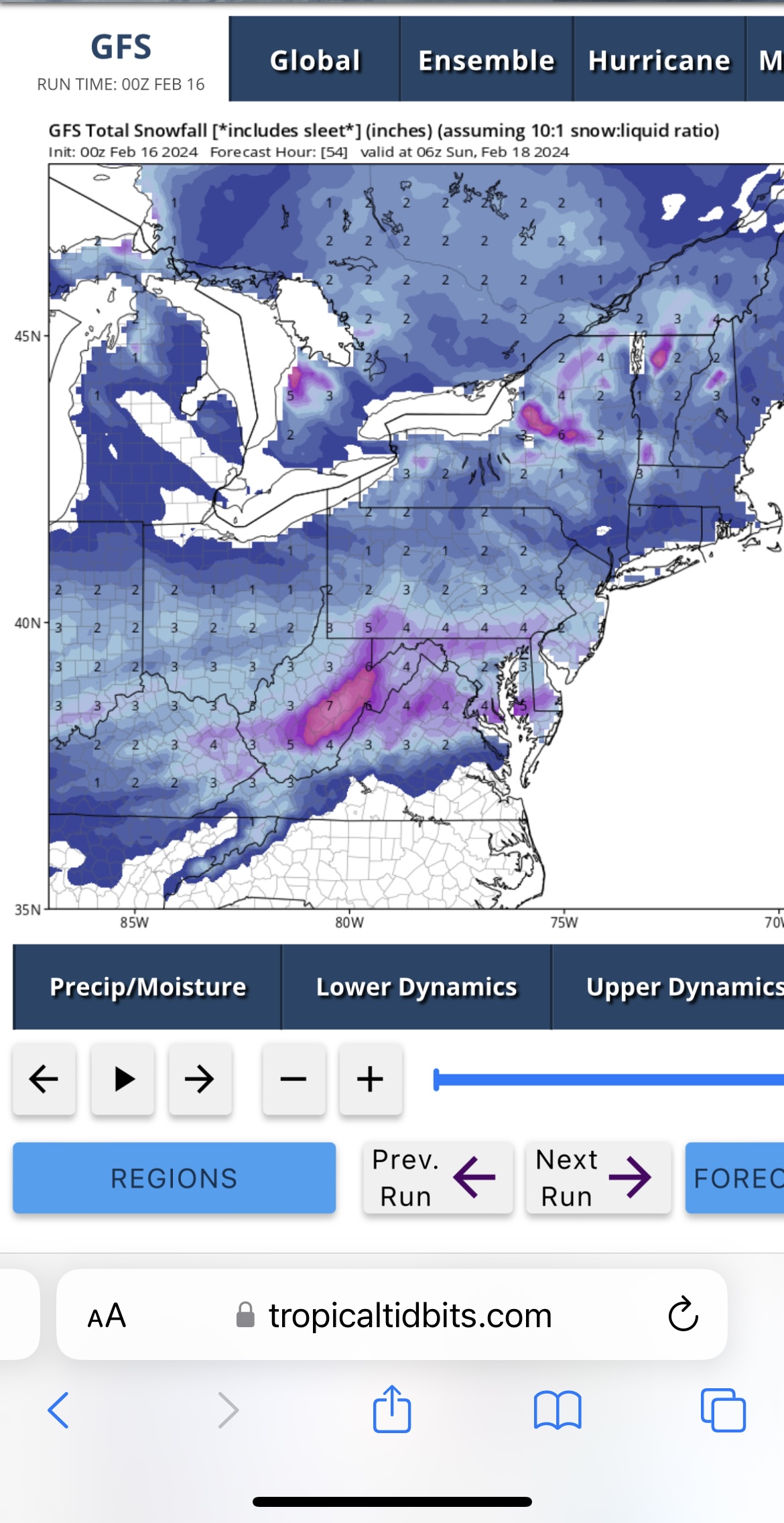
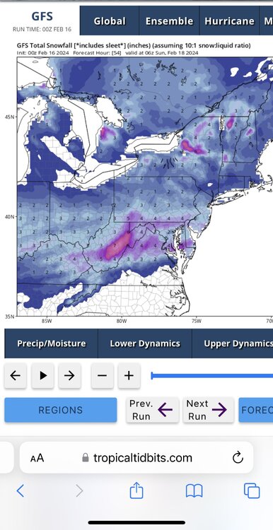
I got you. GFS 10-1. Another bump north and juicier.
-
That’s a sweet map. I think there’s another 25 mile bump north yet before show time.
-
I’m typically a defender of the central NWS as well, but I’m getting tired of the York, Lebanon, Lancaster circle of no headlines when we’re encircled by counties with headlines. Also, slow to react lately when all of the data shows they should be.
-
Nice bump north on the GFS. More juiced than it’s 12Z run.
-
Maps Bro! Did you not read ITT’s post??
-
The Euro/NAM is the old EE rule I believe. Both show top end advisory/nearing warning criteria amounts. Let’s see if the GFS bumps up.
-
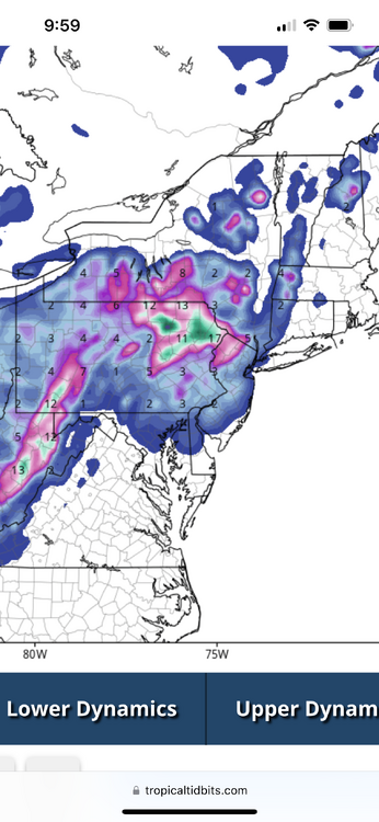
Looks like the 18Z NAM 10:1
-
NAM’ing inbound
-
The 10-1 looks higher on TT than the Kuch map posted. Would t expect that.
-
Wait until you see 36
-
@Itstrainingtime Thanks for posting those “tributes”. Very well done, and like you this place has been an integral part of my winters going WAY back. Thanks to everyone who keeps it going and especially @Blizzard of 93 for the snow maps that I look forward to all winter. Now time to get NAM’d and get Blizz his warning criteria.
-
GFS is…not great