GrandmasterB
-
Posts
805 -
Joined
-
Last visited
Content Type
Profiles
Blogs
Forums
American Weather
Media Demo
Store
Gallery
Everything posted by GrandmasterB
-

Central PA Winter 2024/2025
GrandmasterB replied to Voyager's topic in Upstate New York/Pennsylvania
5.8” on .50 liquid -
Central PA Winter 2024/2025
GrandmasterB replied to Voyager's topic in Upstate New York/Pennsylvania
I would expect warnings to fly soon especially after that Euro run. -
Central PA Winter 2024/2025
GrandmasterB replied to Voyager's topic in Upstate New York/Pennsylvania
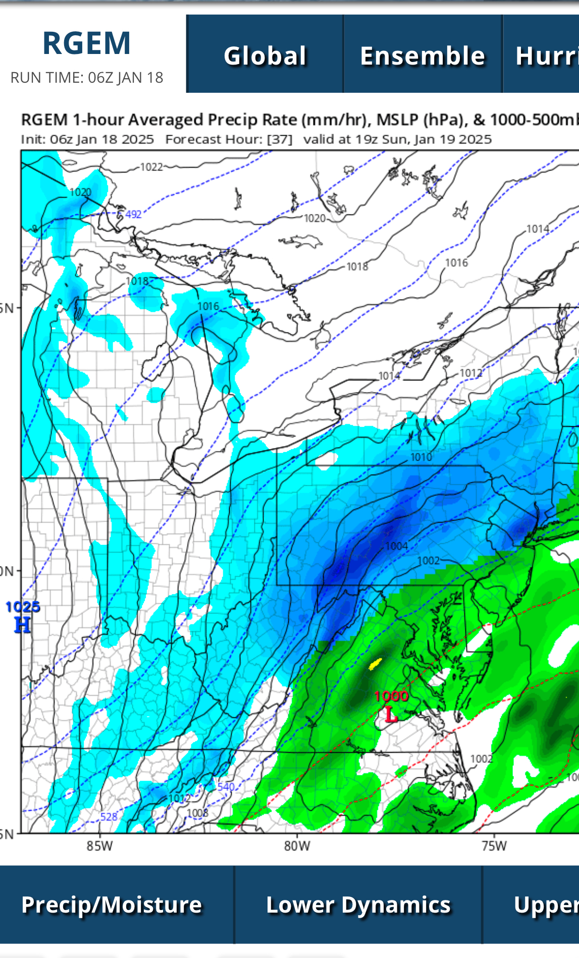
Hard to know who’s way off yet since we don’t have verification, but this look by the RGEM is a lot different than the 6Z Euro. This is rain in a lot of places Euro is 6”+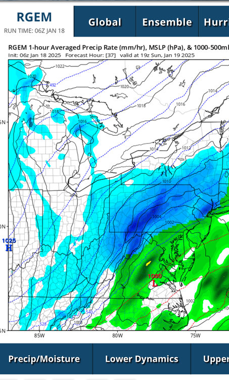
-
Central PA Winter 2024/2025
GrandmasterB replied to Voyager's topic in Upstate New York/Pennsylvania
I’m going to go out on a limb here and say the Euro won’t be too far southeast by 100+ miles within 24 hours of go-time. -
Central PA Winter 2024/2025
GrandmasterB replied to Voyager's topic in Upstate New York/Pennsylvania
Ukie looks just a touch southeast from the GFS. Going to be a VERY interesting Euro run. -
Central PA Winter 2024/2025
GrandmasterB replied to Voyager's topic in Upstate New York/Pennsylvania
Great to wake up and see the 6Z GFS run. Maybe we all have a little wiggle room east or west too if there are any shifts in track. -
Central PA Winter 2024/2025
GrandmasterB replied to Voyager's topic in Upstate New York/Pennsylvania
GFS looks nice at 66. Storm is stronger too vs. 18Z very ninja’d -
Central PA Winter 2024/2025
GrandmasterB replied to Voyager's topic in Upstate New York/Pennsylvania
12Z NAM didn’t even have a low pressure area reflected so in my opinion it shifted infinity% to the west. -
Central PA Winter 2024/2025
GrandmasterB replied to Voyager's topic in Upstate New York/Pennsylvania
Seems like the Euro is the far right/driest goal post at the moment. -
Central PA Winter 2024/2025
GrandmasterB replied to Voyager's topic in Upstate New York/Pennsylvania
The tracking has not been boring. Looks like an active pattern with some chances over the next 5-10 days. -
Central PA Winter 2024/2025
GrandmasterB replied to Voyager's topic in Upstate New York/Pennsylvania
NAM with a noticeable tick north on snow accums. -
Central PA Winter 2024/2025
GrandmasterB replied to Voyager's topic in Upstate New York/Pennsylvania
Agree with you Blizz and I think it will come back north maybe 30 miles or so once the low starts to strengthen. Just frustrating that it’s so close and we can’t get the north trend when we need it. -
Central PA Winter 2024/2025
GrandmasterB replied to Voyager's topic in Upstate New York/Pennsylvania
Another step back from 6Z though. The initial slug of precip is looking less and less impressive as dry air east of the mountains is taking a bite out of it. You can see that pretty easily on the accum map. Disappointing we can’t get favorable trends in such a nice set-up. -
Central PA Winter 2024/2025
GrandmasterB replied to Voyager's topic in Upstate New York/Pennsylvania
GFS was only slightly south but it made a big difference on the northern edge since it’s a tight gradient up here. -
Central PA Winter 2024/2025
GrandmasterB replied to Voyager's topic in Upstate New York/Pennsylvania
I fully support this -
Central PA Winter 2024/2025
GrandmasterB replied to Voyager's topic in Upstate New York/Pennsylvania
Where do you get the 0Z at 8:30? -
Central PA Winter 2024/2025
GrandmasterB replied to Voyager's topic in Upstate New York/Pennsylvania
Starting to get into solid model verification time as well (under 96 hours). You have to like where central sits for this one. -
Central PA Winter 2024/2025
GrandmasterB replied to Voyager's topic in Upstate New York/Pennsylvania
Not great! -
Central PA Winter 2024/2025
GrandmasterB replied to Voyager's topic in Upstate New York/Pennsylvania
12Z Euro bumped up totals for tomorrow compared to 0Z. As for the PSU talk…I couldn’t pass up on the cheap tickets. Hopefully, it’s not too cold and you guys are right about the outcome. Our defense can be exploited with speed. -
Central PA Autumn 2024
GrandmasterB replied to Itstrainingtime's topic in Upstate New York/Pennsylvania
Mulch is caving -
Central PA Autumn 2024
GrandmasterB replied to Itstrainingtime's topic in Upstate New York/Pennsylvania
Been snowing lightly all day with no accums, but awesome to watch! I like where we sit for next week. It’s an easy way to score if the boundary is far enough south. Not a complicated set-up just need to hope it’s south of your hood. -
Central PA Autumn 2024
GrandmasterB replied to Itstrainingtime's topic in Upstate New York/Pennsylvania
Haha, figured you’d object to that Blizz! -
Central PA Autumn 2024
GrandmasterB replied to Itstrainingtime's topic in Upstate New York/Pennsylvania
I don’t care if it’s just some light snow that doesn’t stick tomorrow. Flakes in the air and a threat to track this early feels like a winter paradise compared to the dumpster fire of the last two years. -
Central PA Autumn 2024
GrandmasterB replied to Itstrainingtime's topic in Upstate New York/Pennsylvania
1-2” now on the lanco NWS point & click -
Central PA Autumn 2024
GrandmasterB replied to Itstrainingtime's topic in Upstate New York/Pennsylvania
This Friday (the 22nd).