GrandmasterB
-
Posts
805 -
Joined
-
Last visited
Content Type
Profiles
Blogs
Forums
American Weather
Media Demo
Store
Gallery
Everything posted by GrandmasterB
-
No idea, but let’s go with it.
-
I can’t believe I’m about to look at the ICON.
-
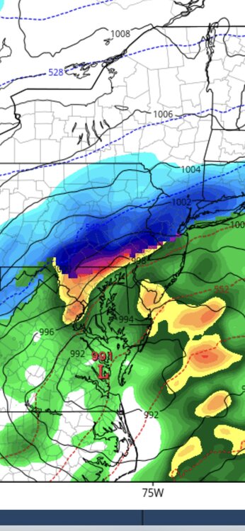
I noticed a little more coastal development on the NAM vs its 6Z run. Something to watch.
-
It’s a little odd seeing the Euro more juiced than the NAM.
-
You and me both!
-
Thanks! Looks like a fairly wide area too, so maybe some wiggle room for any shifts in track.
-
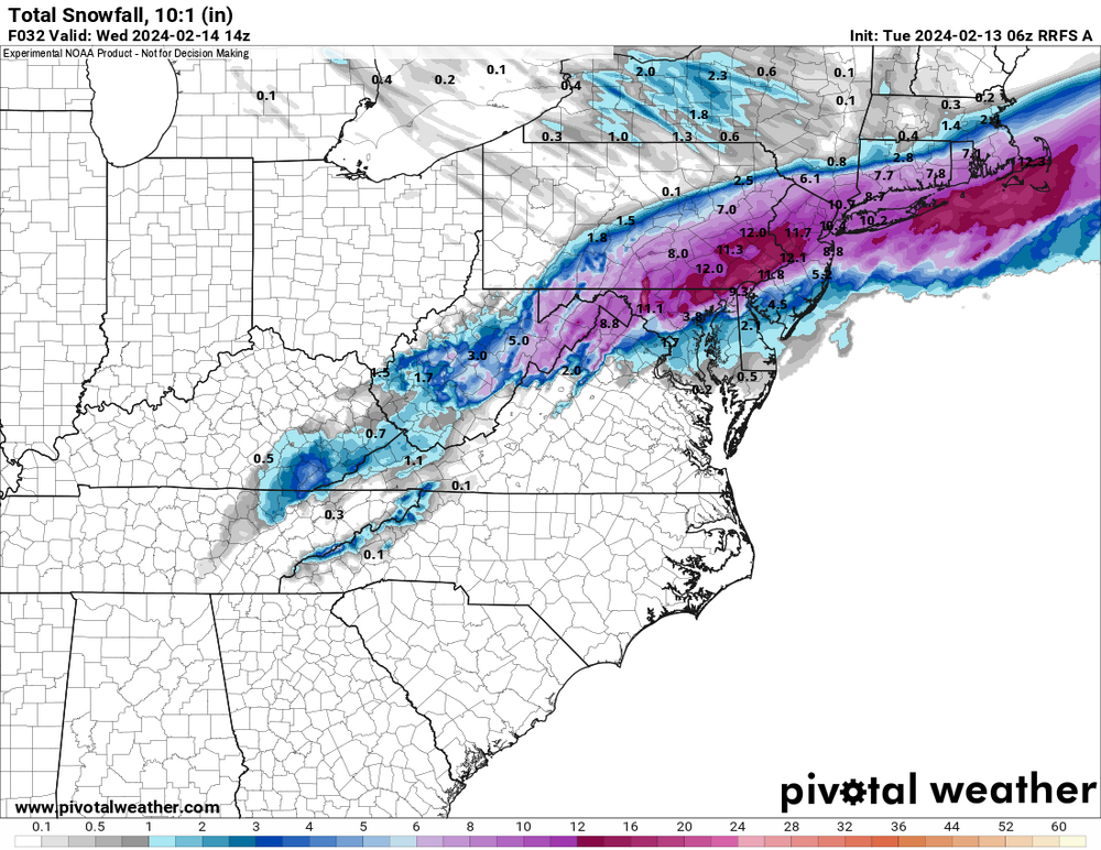
Do you have a snow map, Bubbler? TT is down for me right now, and I love a good NAM clown map.
-
Certainly some weenie optimism in this take, but this is the type of set-up that could bump north in the last 24-36 hours. It would be a kick in the nuts to NVA and southern MD crew, but that’s even more reason to believe it will happen.
-
This is interesting data. Thanks for compiling it. A few things that stood out to me for this event. Of course, Euro was terrible as mentioned by others. Just horrible. The GFS was quite good overall and is having an impressive season IMO. The RGEM should be discontinued.
-
Straight to the HOF. Absolute peak.
-
I’m at the very top of the hill at Speedwell.
-
I’m on top of a large hill and very far north…just one mile to the TP so I often do better than other Lancaster locales.
-
Starting to wind down. Just a shade under 6” total. What a great morning! Waking up at 4am was well worth it.
-
Still moderate here. Should be closing in on 6”. Warning level will verify and 24 hours ago I didn’t have an advisory.
-
Just measured 4” and still ripping. Great event!
-
Maybe heaviest rates of the storm right now. Down to nearly 1/4 visibility. Nukeage.
-
Another increase on the latest HRRR.
-
Rates have steadily increased the last 45 minutes. I’m going to estimate it’s very close to “pukeage” right now.
-
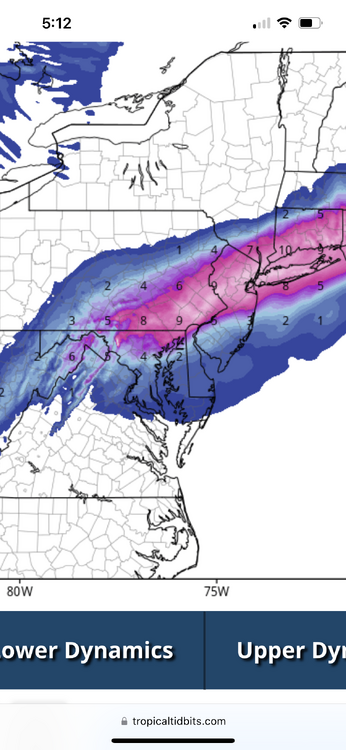
LOL, Philly with 10” on the GFS. This is about to get crazy!
-
No idea what this model is, but I’ll take the 12 it has me getting.

-
Woke up at 4am to watch frozen water fall from the sky. Normal hobby.
-
Big hit for all of central on the GFS. Should be interesting tomorrow am. Ninja’d
-
RGEM with some insane rates
-
Saw this on X. No idea if it’s true: “Air Force Hurricane Hunters are out this evening sampling the atmosphere ahead of the developing Nor'easter. 10-15 dropsondes will be dropped and will help our models get a better grasp on the forecast.”
-
I said it earlier and I’ll say it again. You are an absolute legend for this one. Never gave up hope and looks like it’s going to deliver!