

GrandmasterB
-
Posts
805 -
Joined
-
Last visited
Content Type
Profiles
Blogs
Forums
American Weather
Media Demo
Store
Gallery
Everything posted by GrandmasterB
-

Central PA Winter 2024/2025
GrandmasterB replied to Voyager's topic in Upstate New York/Pennsylvania
Tick tick tick north. Still 48 hours to go. -
Central PA Winter 2024/2025
GrandmasterB replied to Voyager's topic in Upstate New York/Pennsylvania
GFS pretty big move north at 0Z -
Central PA Winter 2024/2025
GrandmasterB replied to Voyager's topic in Upstate New York/Pennsylvania
0Z NAM is much further north with precip for storm #2. For those that celebrate. -
Central PA Winter 2024/2025
GrandmasterB replied to Voyager's topic in Upstate New York/Pennsylvania
Interesting backbuilding of heavy cells southwest of Pittsburgh. Please tell Ruin. -
Central PA Winter 2024/2025
GrandmasterB replied to Voyager's topic in Upstate New York/Pennsylvania
Tuesday is still doable, but we need north trends starting with HH today. Where is Blizz to inject some optimism in here?? -
Central PA Winter 2024/2025
GrandmasterB replied to Voyager's topic in Upstate New York/Pennsylvania
Latest HRRR is quite dry for this evening. If Tuesday stays south and Thursday/Friday cuts I’m going full Ruin in here. -
Central PA Winter 2024/2025
GrandmasterB replied to Voyager's topic in Upstate New York/Pennsylvania
That’s total precip for the event. Some spots in the south barely over .1 -
Central PA Winter 2024/2025
GrandmasterB replied to Voyager's topic in Upstate New York/Pennsylvania
This is concerning for tonight on the 12Z NAM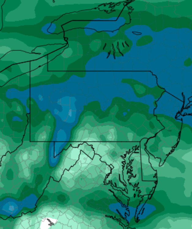
-
Central PA Winter 2024/2025
GrandmasterB replied to Voyager's topic in Upstate New York/Pennsylvania
I don’t think anyone should write off the Tuesday system just yet. North trends are notorious for a reason. -
Central PA Winter 2024/2025
GrandmasterB replied to Voyager's topic in Upstate New York/Pennsylvania
Why is Ruin not red tagged? -
Central PA Winter 2024/2025
GrandmasterB replied to Voyager's topic in Upstate New York/Pennsylvania
Storm #1 is plenty cold on the NAM. I’m more worried about enough precip as other models are fairly dry. -
Central PA Winter 2024/2025
GrandmasterB replied to Voyager's topic in Upstate New York/Pennsylvania
Add that GFS run to the fully tented pile! My goodness. -
Central PA Winter 2024/2025
GrandmasterB replied to Voyager's topic in Upstate New York/Pennsylvania
For the tonight thing. Interesting note by CTP in the latest update. Bolding is mine: NEAR TERM /UNTIL 10 PM THIS EVENING/... 10-20F degree dewpoint depressions or T/Td spread continues to prevent light snow returns over the southern tier counties from reaching the ground. This setup should eventually help to enhance the llvl cold air due to favorable evaporative cooling and wet bulb effects as precip begins to spread from southwest to northeast and pick up in intensity late tonight/after midnight. -
Central PA Winter 2024/2025
GrandmasterB replied to Voyager's topic in Upstate New York/Pennsylvania
Dewpoints are low so not sure that matters too much. -
Central PA Winter 2024/2025
GrandmasterB replied to Voyager's topic in Upstate New York/Pennsylvania
Pretty strong wording from him. Interesting to see how CTP plays this one. Could make the case for watches further SE instead of advisories, but it’s a close call. -
Central PA Winter 2024/2025
GrandmasterB replied to Voyager's topic in Upstate New York/Pennsylvania
GFS is a tick colder for the Wednesday night deal. Surface temps in the upper 20’s. -
Central PA Winter 2024/2025
GrandmasterB replied to Voyager's topic in Upstate New York/Pennsylvania
Agree and I’m also noticing that the sleet accumulation maps have accums south of the M/D line which makes me think it will hang on even in southern PA for quite awhile. -
Central PA Winter 2024/2025
GrandmasterB replied to Voyager's topic in Upstate New York/Pennsylvania
Yeah, great question. That’s why I enjoy tracking ice storms. They can be tricky because heavy rain at 30 degrees doesn’t do a lot. Pretty much just runs off before it can accrete. But an 80/20 mix of freezing rain and sleet coming down light or moderate at 28 degrees can by highly impactful. We’ve witnessed busts in both directions with these set-ups. A lot of nuance. -
Central PA Winter 2024/2025
GrandmasterB replied to Voyager's topic in Upstate New York/Pennsylvania
It’s rare. If we start out with temps in the upper 20’s when the precip arrives it’s difficult to dislodge historically. -
Central PA Winter 2024/2025
GrandmasterB replied to Voyager's topic in Upstate New York/Pennsylvania
Colder run of the GFS for Thursday. Temps in the upper 20’s with sleet/freezing rain. Interesting to see if that holds or not. 28 vs. 31 makes a pretty big difference as precip is falling. -
Central PA Winter 2024/2025
GrandmasterB replied to Voyager's topic in Upstate New York/Pennsylvania
At least 8” in my yard and still moderate. Amazing storm!! Great tracking with everyone! -
Central PA Winter 2024/2025
GrandmasterB replied to Voyager's topic in Upstate New York/Pennsylvania
Just came in from sledding and it is blizzarding. Maybe 100 yards of visibility. Glorious is the right word! -
Central PA Winter 2024/2025
GrandmasterB replied to Voyager's topic in Upstate New York/Pennsylvania
I’ve noticed the back building to the south and west. I know it’s moving quick, but I think we have a few hours of this to go. -
Central PA Winter 2024/2025
GrandmasterB replied to Voyager's topic in Upstate New York/Pennsylvania
Absolutely ripping -
Central PA Winter 2024/2025
GrandmasterB replied to Voyager's topic in Upstate New York/Pennsylvania
Light flurries and pretty bright. No accumulation. Not what I expected at 1:30.


