

GrandmasterB
-
Posts
805 -
Joined
-
Last visited
Content Type
Profiles
Blogs
Forums
American Weather
Media Demo
Store
Gallery
Everything posted by GrandmasterB
-

Central PA Winter 25/26 Discussion and Obs
GrandmasterB replied to MAG5035's topic in Upstate New York/Pennsylvania
Dewpoints on the 84 hour NAM with precip on the doorstep. Don't see this very often: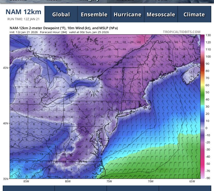
-
Central PA Winter 25/26 Discussion and Obs
GrandmasterB replied to MAG5035's topic in Upstate New York/Pennsylvania
You new here? my worry with amplification is we still have such a long way to go (72+ hours), but the WAA thump looks prodigious regardless of how far the primary pushes north. -
Central PA Winter 25/26 Discussion and Obs
GrandmasterB replied to MAG5035's topic in Upstate New York/Pennsylvania
That was going to be awesome -
Central PA Winter 25/26 Discussion and Obs
GrandmasterB replied to MAG5035's topic in Upstate New York/Pennsylvania
My amateur thoughts on the 18Z GFS. First, welcome back to the party. Second, I think its snow map is our floor for this event. GFS gets that done through mostly over-running. It moves the low from Hatteras basically due east. If that comes up the coast at all like the Ukie or Euro then we can up the totals here. -
Central PA Winter 25/26 Discussion and Obs
GrandmasterB replied to MAG5035's topic in Upstate New York/Pennsylvania
Adding to what MAG and AccuChris stated on ratios here’s Millville from MA forum, “If you are north of the M/D, your average ratios will likely be >13:1” -
Central PA Winter 25/26 Discussion and Obs
GrandmasterB replied to MAG5035's topic in Upstate New York/Pennsylvania
Just based on QPF, I like the 12Z run a little better than the 0Z run. Solid hold for sure and nowhere near the GFS. -
Central PA Winter 25/26 Discussion and Obs
GrandmasterB replied to MAG5035's topic in Upstate New York/Pennsylvania
Ukie doesn’t exactly agree with the GFS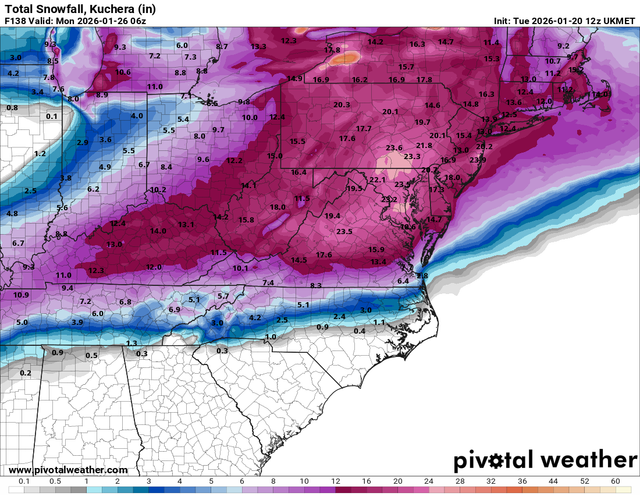
-
Central PA Winter 25/26 Discussion and Obs
GrandmasterB replied to MAG5035's topic in Upstate New York/Pennsylvania
I’d prefer the slower solution as long it means the phase is cleaner and the energy doesn’t get left behind. Confluence was actually stronger on the CMC compared to 0Z, but the phase was cleaner making it a far more amped solution than the GFS. -
Central PA Winter 25/26 Discussion and Obs
GrandmasterB replied to MAG5035's topic in Upstate New York/Pennsylvania
Confluence is stronger on the GFS, but what really hurts is the energy in the southwest gets cut off and the phase is nothing like the Euro. You could see that pretty early on in the run. Hopefully the Euro holds. -
Central PA Winter 25/26 Discussion and Obs
GrandmasterB replied to MAG5035's topic in Upstate New York/Pennsylvania
I remember the modeling really hitting the sharp cutoff in the lead up to that event. It pretty much verified just a bit further north. This one is not currently modeled as extreme a cutoff as that event. Another positive that’s already been mentioned is the ratios will help us up here too. So I’ll be trying not to live and die with the QPF output, but will end up doing just that anyway. Will be a long week for sure. -
Central PA Winter 25/26 Discussion and Obs
GrandmasterB replied to MAG5035's topic in Upstate New York/Pennsylvania
Also quite a bit slower. I think that would help us up here. -
Central PA Winter 25/26 Discussion and Obs
GrandmasterB replied to MAG5035's topic in Upstate New York/Pennsylvania
I like where we are sitting still 5 days out: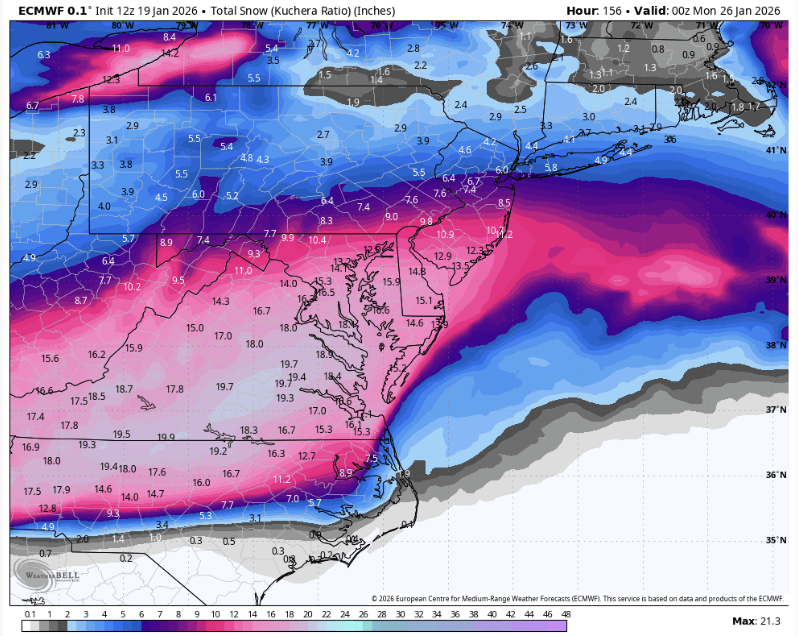
-
Central PA Winter 25/26 Discussion and Obs
GrandmasterB replied to MAG5035's topic in Upstate New York/Pennsylvania
Saw the Ukie output in the MA forum and holy ****! High potential set-up. I believe MAG called this time period a day or so ago. -
Central PA Winter 25/26 Discussion and Obs
GrandmasterB replied to MAG5035's topic in Upstate New York/Pennsylvania
What a wintry day. Solid pack and light snow at dusk. A few cold days coming up and plenty of tracking ahead!! -
Central PA Winter 25/26 Discussion and Obs
GrandmasterB replied to MAG5035's topic in Upstate New York/Pennsylvania
Got back from NYC this morning and was surprised with the amount of snow here. Seems like 3” on the driveway. -
Central PA Winter 25/26 Discussion and Obs
GrandmasterB replied to MAG5035's topic in Upstate New York/Pennsylvania
From a met in the NE forum. Sign me up! “Seems a pretty straightforward setup for back half Jan, rebuild source region in western Canada late next week/weekend, likely leaking cold into the northast at times with GOA ridging (-EPO) beyond. Chances for coastals during transition periods, and perhaps a more active southern stream from MLK and after.” -
Central PA Winter 25/26 Discussion and Obs
GrandmasterB replied to MAG5035's topic in Upstate New York/Pennsylvania
“Here's a BIG reason to be skeptical of a monster snowstorm in the mid-Atlantic States through mid-Jan…” -MU Incredibly bold call to predict no “monster” snowstorms in the next two to three weeks. -
Central PA Winter 25/26 Discussion and Obs
GrandmasterB replied to MAG5035's topic in Upstate New York/Pennsylvania
I don’t need a Met to tell me the odds of a big snowstorm are low. Of course they are. It’s relatively rare to get a double digit snowfall around here. Seems like he’s simply playing the percentages and then gloating about it. -
Central PA Winter 25/26 Discussion and Obs
GrandmasterB replied to MAG5035's topic in Upstate New York/Pennsylvania
MU vs. Eric Webb battle on X -
I live in Lititz. Glad you like the town. DM me if you need advice on anything while you’re here!
-
Central PA Winter 25/26 Discussion and Obs
GrandmasterB replied to MAG5035's topic in Upstate New York/Pennsylvania
Anyone else having tiny, mangled flakes mixing with the sleet? -
Central PA Winter 25/26 Discussion and Obs
GrandmasterB replied to MAG5035's topic in Upstate New York/Pennsylvania
20 years on weather forums and I never considered blocking anyone, but just straight up giving bad obs and I’m very close to having to do so with Ruin. 33 man c’mon. -
Central PA Winter 25/26 Discussion and Obs
GrandmasterB replied to MAG5035's topic in Upstate New York/Pennsylvania
I remember when he posted in the Philly forum under NYNJWeather. Skilled met but often times too aggressive with snow maps. I grew to appreciate Horst when he was posting for MU. He was conservative but quite often more accurate than other calls. The new MU account is so clearly warm biased that it detracts from their messaging. -
Central PA Winter 25/26 Discussion and Obs
GrandmasterB replied to MAG5035's topic in Upstate New York/Pennsylvania
I enjoyed tracking this storm simply from the uniqueness of the event. Not often you see a storm that’s primarily ice from the onset. Especially with temps in the 20’s and dews in the teens. We are usually hovering around 30/31 which makes ice accretion difficult. Let’s see what this storm has in store for everyone. -
Central PA Winter 25/26 Discussion and Obs
GrandmasterB replied to MAG5035's topic in Upstate New York/Pennsylvania
Thanks Blizz. 12Z Euro appears a little snowier to me than the 0Z run. I use the crappy free site, so if someone has nice maps to share please and thank you!!


