GrandmasterB
-
Posts
805 -
Joined
-
Last visited
Content Type
Profiles
Blogs
Forums
American Weather
Media Demo
Store
Gallery
Everything posted by GrandmasterB
-

Central PA Winter 25/26 Discussion and Obs
GrandmasterB replied to MAG5035's topic in Upstate New York/Pennsylvania
I believe that was going to be fun to look at had it gone past 84 hours! -
Central PA Winter 25/26 Discussion and Obs
GrandmasterB replied to MAG5035's topic in Upstate New York/Pennsylvania
Are we taking the 981 closest to the bay or the 957 nuke a little further east?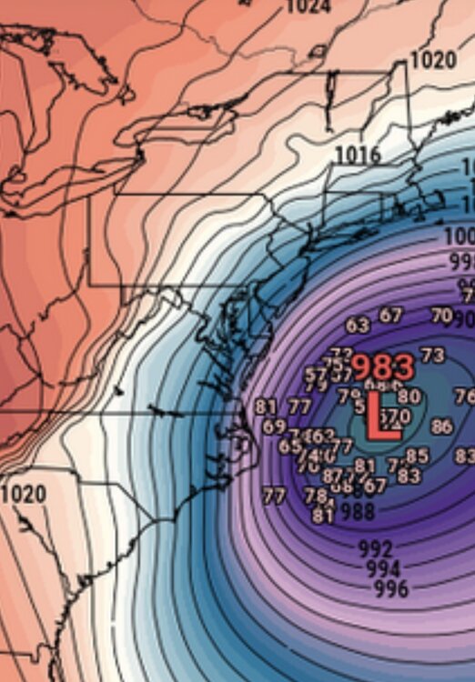
-
Central PA Winter 25/26 Discussion and Obs
GrandmasterB replied to MAG5035's topic in Upstate New York/Pennsylvania
18Z EPS ensembles. Big move northwest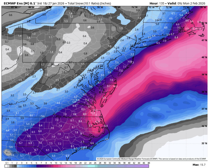
-
Central PA Winter 25/26 Discussion and Obs
GrandmasterB replied to MAG5035's topic in Upstate New York/Pennsylvania
Ripped from MA but I think this is spot on messaging. It’s an extremely delicate set-up where a 100 mile shift will make a significant sensible weather difference: KEY MESSAGE 3...Monitoring the potential for a coastal system this weekend. Very favorable storm patten in terms of analogs for big snows in the Mid-Atlantic this weekend. A 50/50 low & -NAO, Idaho Ridge, blocking over the Hudson Bay, and trough moving into the east Pac. Couldn`t ask for a better synoptic setup, but the formation of a storm remains in the details of this highly sensitive pattern. Guidance continues to show a Miller A type Nor`easter (it has been a while for one to form, let alone show up in model guidance). While the ceiling is certainly high for this storm, there is equally if not higher odds it just skirts out to see as indicated by the latest 00Z guidance and ensembles. Future runs will have to be seen if this is a trend or noise. How the TPV evolves will be one of the biggest factors on if this storm comes to fruition or not and impacts land. Regardless, expect fluctuations over the next day or two until the pattern is better sampled as associated energy is onshore across the western US. -
Central PA Winter 25/26 Discussion and Obs
GrandmasterB replied to MAG5035's topic in Upstate New York/Pennsylvania
Read more and post less for now. There are dozens of model runs throughout the day and locking in any one model solution 72+ hours out is foolish. I suggest reading the NWS discussions each day and learning from the seasoned folks on this board. Saying “congrats X location” or “way east” after each run will get a lot of buns thrown your way. -
Central PA Winter 25/26 Discussion and Obs
GrandmasterB replied to MAG5035's topic in Upstate New York/Pennsylvania
12.5 makes Blizz a razor’s edge winner over canderson. Nice work Blizz! I will DM you in a bit. -
Central PA Winter 25/26 Discussion and Obs
GrandmasterB replied to MAG5035's topic in Upstate New York/Pennsylvania
I’d love to track another one this week. This is how to run a winter! -
Central PA Winter 25/26 Discussion and Obs
GrandmasterB replied to MAG5035's topic in Upstate New York/Pennsylvania
If 14” is official that would make @pasnownutthe winner with an entry of 13.9”, just edging out @Itstrainingtime(14.2) who wasn’t even in the state. -
Central PA Winter 25/26 Discussion and Obs
GrandmasterB replied to MAG5035's topic in Upstate New York/Pennsylvania
Is this the official number then? -
Central PA Winter 25/26 Discussion and Obs
GrandmasterB replied to MAG5035's topic in Upstate New York/Pennsylvania
“Pretty darn close to the snow/sleet line”. I was speaking for our area. -
Central PA Winter 25/26 Discussion and Obs
GrandmasterB replied to MAG5035's topic in Upstate New York/Pennsylvania
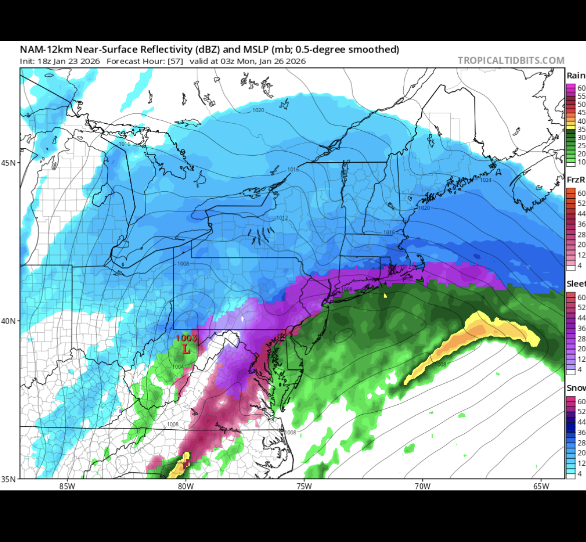
Going back to happy hour NAM from Friday. Pretty darn close on the snow/sleet line.
-
Central PA Winter 25/26 Discussion and Obs
GrandmasterB replied to MAG5035's topic in Upstate New York/Pennsylvania
50/50 snow sleet. Crazy. I’m not sure how many times I’ve ever seen it go back to snow after warming to sleet. Zero maybe? -
Central PA Winter 25/26 Discussion and Obs
GrandmasterB replied to MAG5035's topic in Upstate New York/Pennsylvania
The contest will likely come down to me vs. Blizz. I have 8.2 and Blizz you took 12.3 putting the number at 10.25. I agree that we have a ways to go yet with accumulating sleet and a changeover back to snow at the end very much in play. -
Central PA Winter 25/26 Discussion and Obs
GrandmasterB replied to MAG5035's topic in Upstate New York/Pennsylvania
My prediction was 8.2 but the next highest guess is pretty far above that. -
Central PA Winter 25/26 Discussion and Obs
GrandmasterB replied to MAG5035's topic in Upstate New York/Pennsylvania
Absolute nukeage. Man, if we can hold onto this for just 2 more hours. -
Central PA Winter 25/26 Discussion and Obs
GrandmasterB replied to MAG5035's topic in Upstate New York/Pennsylvania
Looks like very heavy returns just to our southwest and inbound. If that is all snow, I think we’ll make a run to double digits even in the southern tier. -
Central PA Winter 25/26 Discussion and Obs
GrandmasterB replied to MAG5035's topic in Upstate New York/Pennsylvania
Trace was one of the predictions of all time. -
Central PA Winter 25/26 Discussion and Obs
GrandmasterB replied to MAG5035's topic in Upstate New York/Pennsylvania
Best rates of the morning so far and it’s really starting to pile up. Radar looks great too. All systems go! -
Central PA Winter 25/26 Discussion and Obs
GrandmasterB replied to MAG5035's topic in Upstate New York/Pennsylvania
You’re in a great spot. I don’t think you end up mixing at all. -
Central PA Winter 25/26 Discussion and Obs
GrandmasterB replied to MAG5035's topic in Upstate New York/Pennsylvania
Blizz, don’t you think that has to be over done for MDT and points south and east? I mean I’m praying and all but the mesos aren’t in the 12-16 range! -
Central PA Winter 25/26 Discussion and Obs
GrandmasterB replied to MAG5035's topic in Upstate New York/Pennsylvania
Good morning all! Does anyone have a good radar for mobile that they like and want to share? -
Central PA Winter 25/26 Discussion and Obs
GrandmasterB replied to MAG5035's topic in Upstate New York/Pennsylvania
Stolen from MA and the LWX office. Interesting: If anything, perhaps some guidance leans slightly slower in terms of a transitioning to sleet Sunday morning. However, not buying into that just yet, and would like to see the 00z guidance roll in with the latest upper air data around the country. Could be something to watch though, as a slower onset of sleet in any one given location could make a significant difference in snow amounts. Will be something to watch this evening into tonight." -
Central PA Winter 25/26 Discussion and Obs
GrandmasterB replied to MAG5035's topic in Upstate New York/Pennsylvania
This is amazing -
Central PA Winter 25/26 Discussion and Obs
GrandmasterB replied to MAG5035's topic in Upstate New York/Pennsylvania
Absolutely razor thin margins down here. Nowcasting will be important. -
Central PA Winter 25/26 Discussion and Obs
GrandmasterB replied to MAG5035's topic in Upstate New York/Pennsylvania
Thanks everyone for all of the commentary on the 18Z runs. Great last minute trends! It’s been fun tracking with you fellas! I hope everyone enjoys the storm. Going out to get wood set-up then pouring a drink!