snowlover2
-
Posts
2,721 -
Joined
-
Last visited
Content Type
Profiles
Blogs
Forums
American Weather
Media Demo
Store
Gallery
Everything posted by snowlover2
-
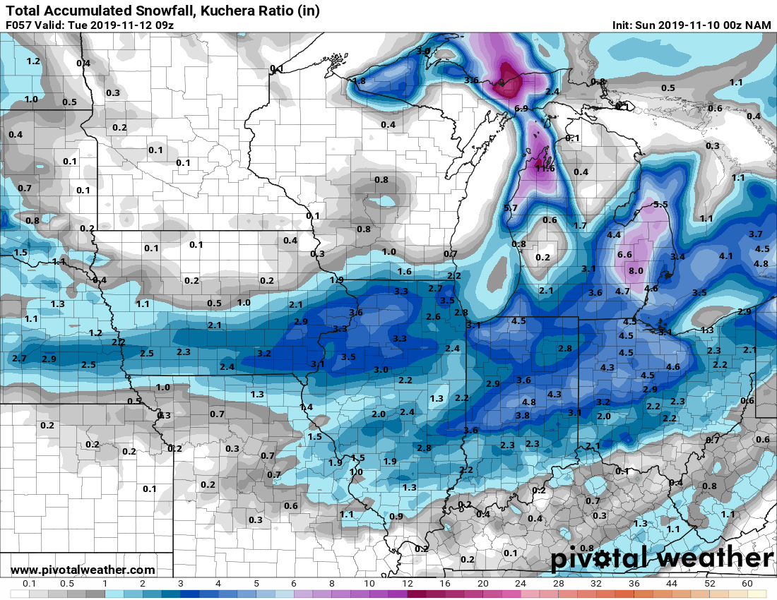
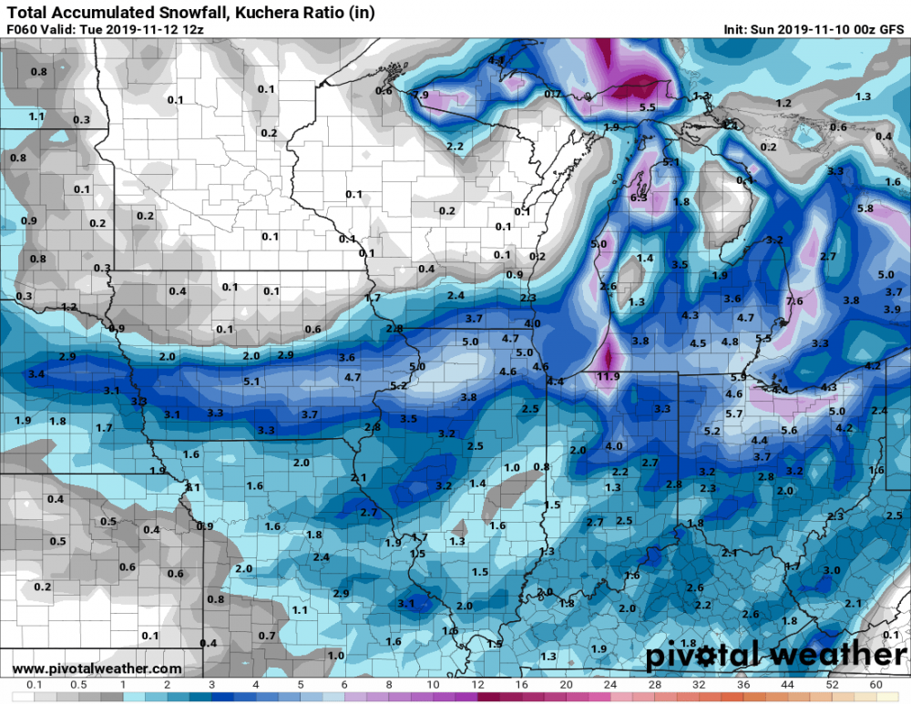
0z GFS
-
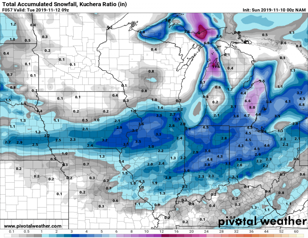
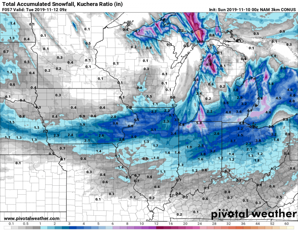
0z NAM and 3K NAM
-

Here comes winter -- October 28-November 1 Snowstorm Potential
snowlover2 replied to Hoosier's topic in Lakes/Ohio Valley
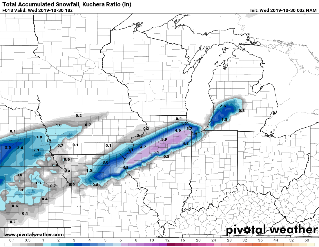
0z NAM for part 1.
-
Here comes winter -- October 28-November 1 Snowstorm Potential
snowlover2 replied to Hoosier's topic in Lakes/Ohio Valley
WAA up for parts of west central IL through tomorrow morning. -
Here comes winter -- October 28-November 1 Snowstorm Potential
snowlover2 replied to Hoosier's topic in Lakes/Ohio Valley
That wouldn't be a terrible track a couple months from now. -
2019 Short/Medium Range Severe Weather Thread
snowlover2 replied to snowlover2's topic in Lakes/Ohio Valley
SPC talking about it some in the day 4-8. -
Well sure feels like fall now. Has to be about 25-30 degrees cooler now than this time yesterday. Only 58 right now.
-
Dayton hit 94 breaking the monthly record of 93.
-
2019 Short/Medium Range Severe Weather Thread
snowlover2 replied to snowlover2's topic in Lakes/Ohio Valley
They did add a 5% tornado area but from NE KS to SW/South Central IA. -
2019 Short/Medium Range Severe Weather Thread
snowlover2 replied to snowlover2's topic in Lakes/Ohio Valley
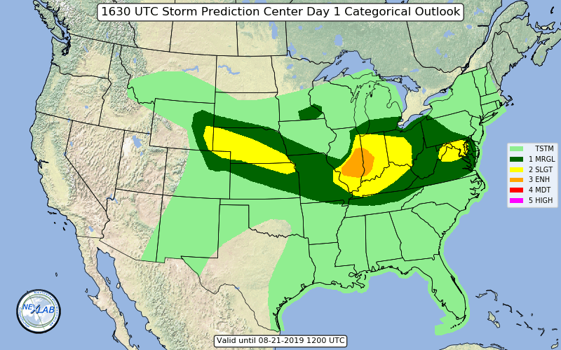
Enhanced added to the IA/IL/MO border area for hail although a 5% tornado area added also.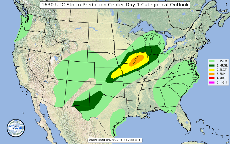
-
Northern parts yes. Also almost forgot March 7,8 2008. Most of the northwestern half of OH were under a blizzard warning receiving 10"+.
-
Actually 2004 pre Christmas dropped 20"+ across the western half of the state so arguably that was the last real big one.
-
New day 1.
-
A few counties in NW IN just added to current watch. That seems pretty telling that it's not going as far south as expected.
-
The new day 3 disco is short but with strong wording calling for a MCS with possible destructive winds because of extreme instability and also saying upgrades being likely in later outlooks. https://www.spc.noaa.gov/products/outlook/day3otlk.html
-
2019 Short/Medium Range Severe Weather Thread
snowlover2 replied to snowlover2's topic in Lakes/Ohio Valley
And the disco mentions an upgrade to moderate risk might be needed later. -
2019 Short/Medium Range Severe Weather Thread
snowlover2 replied to snowlover2's topic in Lakes/Ohio Valley
An enhanced area has been added to central IL for tomorrow on new day 2.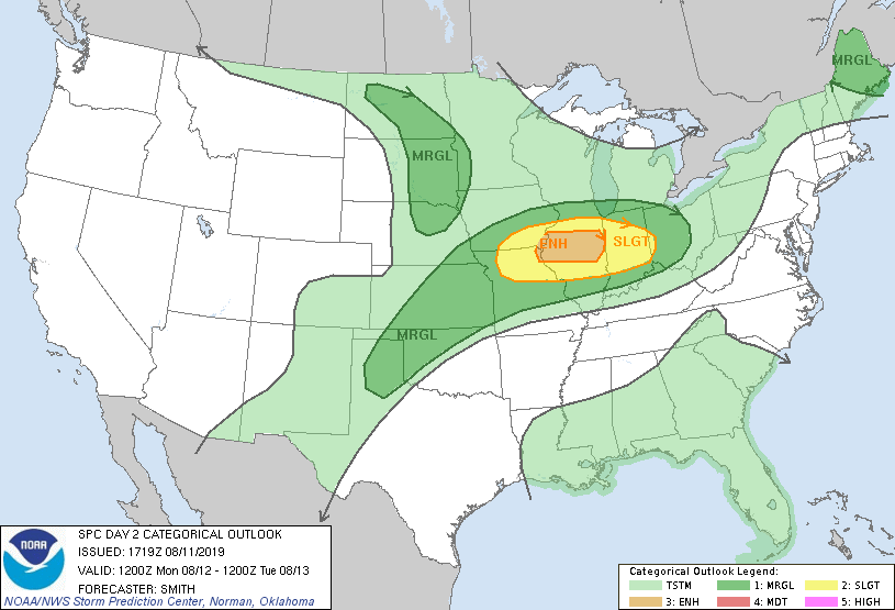
-
Warning just west of me with a 61mph winds reported at the Dayton Airport.
-
7-19 Severe outbreak MN into upper MI
snowlover2 replied to janetjanet998's topic in Lakes/Ohio Valley
You are correct. It was a tornado watch from MO/AR to KY/TN. There were 2 PDS severe thunderstorm watches to the west of that earlier that morning. https://www.spc.noaa.gov/products/watch/2009/ww0267.html -
2019 Short/Medium Range Severe Weather Thread
snowlover2 replied to snowlover2's topic in Lakes/Ohio Valley
Also mentioned possibly a derecho. Day 1 Convective Outlook NWS Storm Prediction Center Norman OK 0736 AM CDT Fri Jul 19 2019 Valid 191300Z - 201200Z ...THERE IS A MODERATE RISK OF SEVERE THUNDERSTORMS EAST-CENTRAL MN AND NORTHERN WI... ...SUMMARY... A regional outbreak of severe thunderstorms with strong tornadoes and potentially widespread significant wind damage may occur from central Minnesota across northern Wisconsin during the mid-afternoon to evening. ...Upper Midwest/Great Lakes... Upgrading to Moderate Risk this outlook for the potential threats of multiple strong tornadoes and a derecho later this afternoon and evening. CAPE/shear/SRH parameter space in this region is forecast to be exceptionally rare for mid July amid a predominately zonal flow regime across the northern states. A convective cluster is ongoing across north-central SD aided by warm/moist advection around 700 mb along a pronounced baroclinic zone. 00Z CAM guidance had a decent handle on this activity earlier this morning and are consistent with a decaying trend through late morning as advection shifts east amid pronounced MLCIN as sampled by the 12Z Aberdeen sounding. There is a low confidence scenario that a strong enough cold pool is becoming established with this early-day cluster such that total decay does not occur. If this occurs, robust boundary-layer heating downstream may be sufficient for an increasing threat during the afternoon of strong to severe wind gusts. This could still yield a scattered to widespread damaging wind scenario, albeit in an earlier time frame than progged by guidance. The more probable scenario is for an extremely unstable air mass (MLCAPE > 4000 J/kg) to become established to from southeast SD through central/southern WI as the elevated mixed-layer overspreads surface dew points rising into the mid to upper 70s. A surface cyclone over central SD should track towards the Twin Cities through early evening. Strong low-level convergence near/northeast of this cyclone along the warm front should sustain surface-based storm development across central into east-central MN. Once initiation occurs, intense supercells will develop rapidly, with an attendant threat for all severe hazards including strong tornadoes amid 50-60 kt effective shear and 0-3 km SRH > 300 m2/s2. The very warm/moist thermodynamic profiles will also support generation of strong cold pools which should eventually yield a bowing, forward-propagating MCS across northern WI into parts of northern Lower and Upper MI. Strength of the vertical shear suggests the potential for intense bowing segments capable of yielding a derecho with significant severe wind gusts -
2019 Short/Medium Range Severe Weather Thread
snowlover2 replied to snowlover2's topic in Lakes/Ohio Valley
Moderate risk now for parts of MN/WI with a 15% tornado area. -
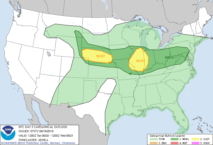
Still the one from yesterday. Seems odd they didn't update it today.
-
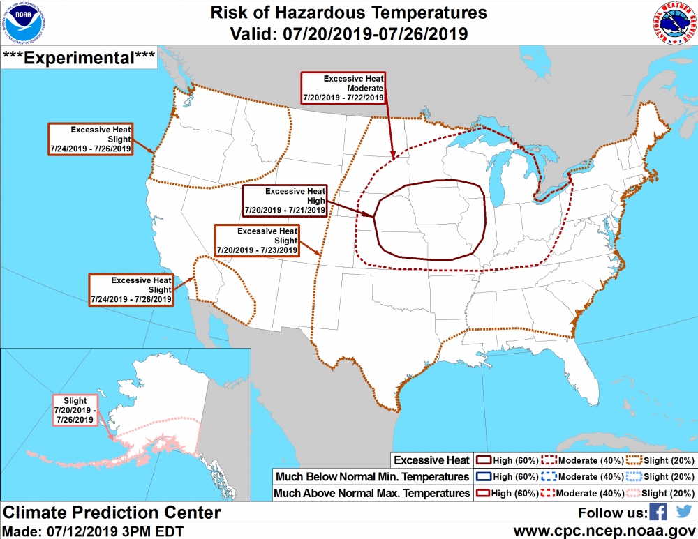
Latest from CPC has a high excessive heat area now for the mid MS Valley area.
-
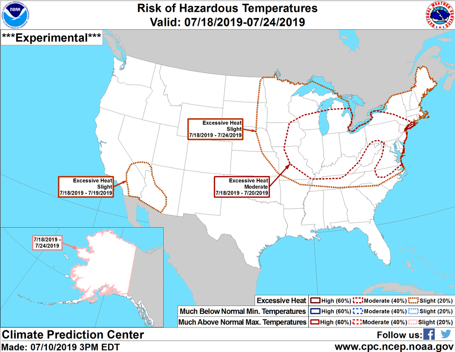
Westward expansion of the extreme heat areas on todays outlook.
-
GFS/Euro both showing DP's getting into the 80's across a decent chunk of the sub which would certainly help verify this.