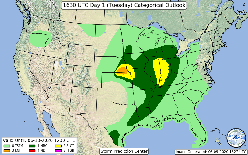
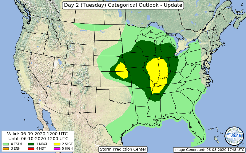
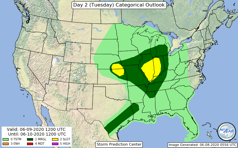
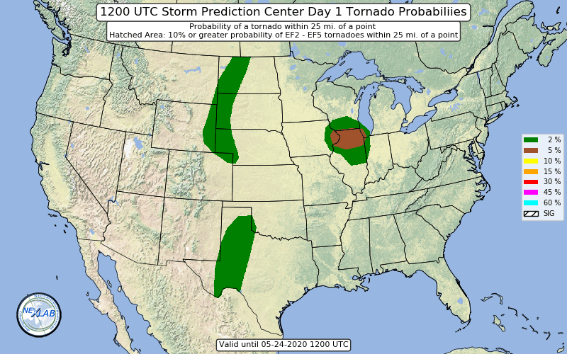
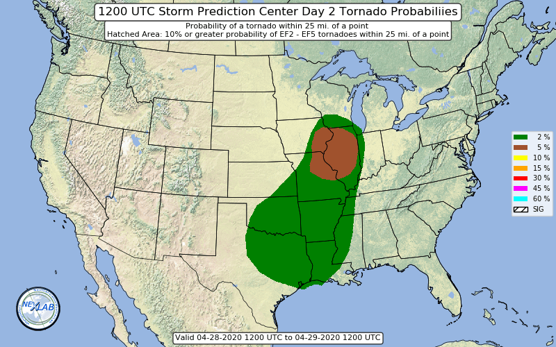
ILN has a very detailed disco in the new afd. They say they wouldn’t be surprised to see an upgrade from the slight risk.
.LONG TERM /TUESDAY THROUGH SATURDAY/...
The long term period is going to start off on an active note, with
several forecast items that warrant a thorough discussion and will
certainly require a close eye as we progress into the beginning of
the workweek.
The first item of concern will be associated with the expectation
for ongoing convection Tuesday morning across at least a portion of
the local area through daybreak. The region will be positioned on
the lee side of a broad mid/upper level ridge axis initially
positioned across the mid-Mississippi River Valley Monday night.
A weak midlevel impulse/disturbance will round the peak of the
aforementioned ridge axis Monday night, with a surface warm front
becoming established from NW to SE across the heart of the Ohio
Valley. With the arrival of increasing forcing for ascent and some
low level convergence becoming established with the aforementioned
frontal boundary generation/frontogenesis, anticipate that a
corridor of NW-to-SE convection will develop initially N/W of the
ILN FA before working its way S/E Monday night into Tuesday morning.
The instby at this point will be mainly elevated in nature,
suggesting that any severe threat would remain rather minimal, even
with a non-zero potential for some small hail as ML instby increases
through the night. The main concern will be the potential for some
heavy rain/training convection, owing to a nearly-parallel
orientation of the low level boundary with the deeper-layer flow.
Additionally, moisture transport into the region will intensify by
late Monday night with the arrival/development of a 30-35+kt H8/H9
jet nosing northeast through the area. The juxtaposition and
parallel orientation between the low level convergent axis and mean
deeper-layer flow, and ingestion of increasingly moist BL air, all
suggest the potential for training storms to develop/become
established -- with early indications favoring a corridor from west-
central into central Ohio. This training activity and potential for
heavy rain/flooding may linger into Tuesday morning before the S/W
energy pulls east and forcing begins to wane by late morning into
the afternoon hours, with a trend toward drier/clearer conditions
possible by mid/late afternoon.
By later Tuesday afternoon into the evening, the setup/environment
expected to develop into the region becomes even a bit more
concerning, for several reasons.
1. The mainly elevated instby working into the area Monday night
into early Tuesday will become surface-based by Tuesday afternoon
into the evening with the influx/advection of moisture-rich BL air
with dewpoints reaching into the low/mid 60s. This will occur
coincident with cooling in the midlevel, yielding a
corresponding steepening of midlevel lapse rates. All of this
adds up to a development of SB/ML CAPE on the order of 1500-2000
j/kg+, depending on your model of choice. Suffice to say that
with ample instby, which will be rooted in the BL, large hail
and translation of strong winds aloft may become increasingly
efficient/possible with any stronger cores that develop by late
Tuesday afternoon into the evening/overnight.
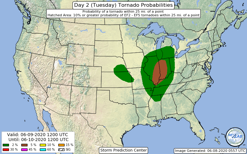
2. Fcst sounding analysis shows long/slightly-curved hodographs
amidst quasi-zonal/WNW deep-layer flow with some /albeit not overly
strong/ low level directional/speed shear developing into the
central part of the Ohio Valley by Tuesday evening/night. This would
tend to suggest, especially in an environment characterized by the
aforementioned instby, that any stronger core/storm that develops
may be able to become supercellular in nature, especially on the
edge of the nosing LLJ moving back into the region by this time.
This being said, the forcing to initiate such development maybe
somewhat lacking late Tuesday afternoon into the evening, lending
itself to at least some uncertainty into how widespread re-
initiation will be /if any/ before the arrival of the stronger S/W
forcing and height falls late Tuesday evening from the west. While
confidence on development of storms late Tuesday afternoon into the
evening in the open warm sector is rather meager at this point,
should a storm be able to develop, it/they would be doing so in an
environment conducive to supercellular formation, of which could
produce any and all severe hazards. This is why the setup will be
monitored so closely, even before the arrival of the main
forcing/most widespread convection late Tuesday evening into the
overnight.
While open warm sector storm initiation during the daytime period on
Tuesday remains somewhat in question, despite the increasingly
favorable environment for intense storms should development occur,
confidence remains much higher in widespread activity moving through
the region by late Tuesday evening into the overnight period. This
activity may initially erupt well to the N/W of the ILN FA even by
early Tuesday evening, courtesy of the aforementioned arrival of
height falls/forcing as the S/W progresses east into a very
thermodynamically- and kinematically-favorable environment. Any
activity later in the evening into the overnight period may be
exhibit more of a cluster/bowing structure, one that potentially
becomes somewhat cold-pool driven the further into the nighttime we
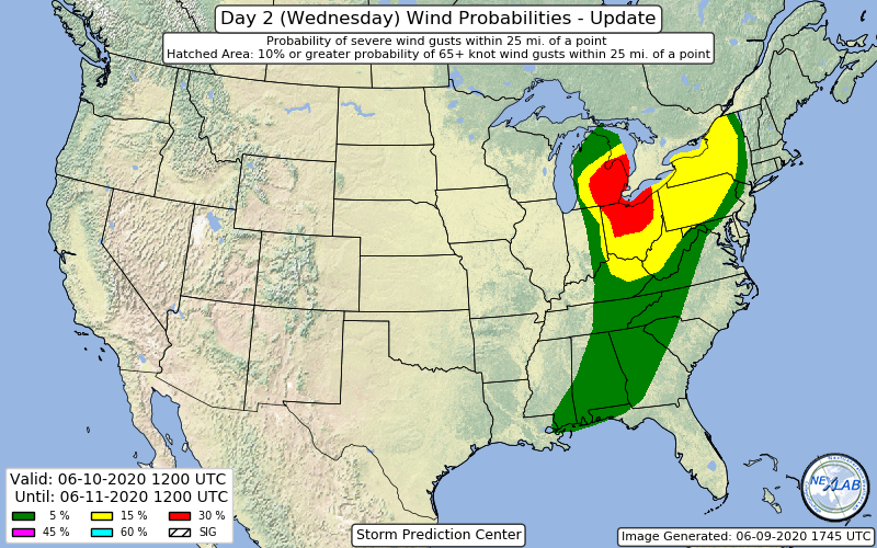
progress. With this in mind, the late evening/overnight activity may
certainly pose a strong/damaging wind threat above all else, but
again all hazards may come into play at one time or another from
late Tuesday afternoon through the nighttime period.
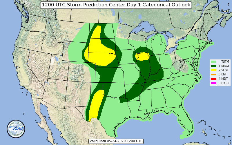
This is certainly a situation and an environment that will be
monitored and analyzed closely, both from a temporal and spatial
perspective. But based on overall pattern setup/recognition, one
which shows support from CIGs analogs, as well as overall
expectation for favorable thermodynamic evolution, we may be dealing
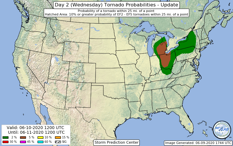
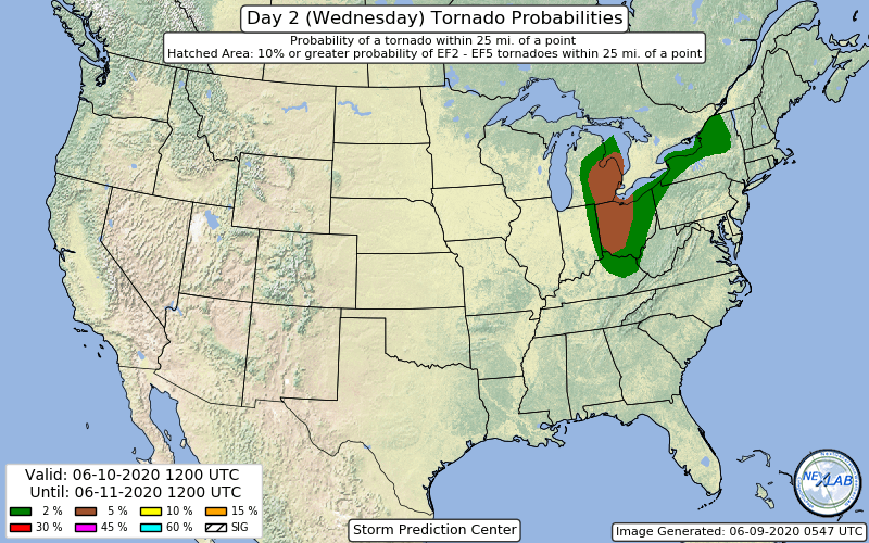
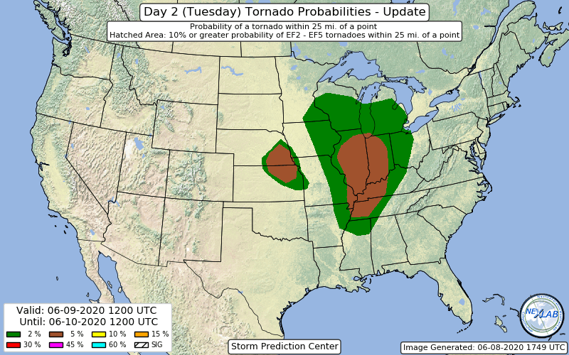
with several rounds of strong to severe storms from Tuesday
afternoon/evening through the overnight period. And this is a
separate concern from the heavy rain/flooding risk that was
mentioned for Monday night/Tuesday morning. Will highlight all of
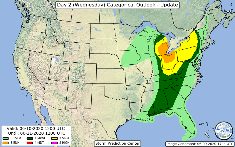
these risks/threats in the HWO, but would not be surprised at all to
see a convective category upgrade (from SLGHT) for Tuesday/night
should current data trends continue.