
snowlover2
-
Posts
2,731 -
Joined
-
Last visited
Content Type
Profiles
Blogs
Forums
American Weather
Media Demo
Store
Gallery
Everything posted by snowlover2
-

2019 Short/Medium Range Severe Weather Thread
snowlover2 replied to snowlover2's topic in Lakes/Ohio Valley
Should have clarified. Like 2 weeks ago there was early/midday rain and then late day storms which suddenly strong rotation and TDS. But yes hopefully won't be as bad. -
2019 Short/Medium Range Severe Weather Thread
snowlover2 replied to snowlover2's topic in Lakes/Ohio Valley
Almost feels like 2 weeks ago all over again. -
2019 Short/Medium Range Severe Weather Thread
snowlover2 replied to snowlover2's topic in Lakes/Ohio Valley
-
2019 Short/Medium Range Severe Weather Thread
snowlover2 replied to snowlover2's topic in Lakes/Ohio Valley
-
2019 Short/Medium Range Severe Weather Thread
snowlover2 replied to snowlover2's topic in Lakes/Ohio Valley
Maintained on newest outlook. Latest disco concerned for supercells and tornadoes later. -
2019 Short/Medium Range Severe Weather Thread
snowlover2 replied to snowlover2's topic in Lakes/Ohio Valley
-
2019 Short/Medium Range Severe Weather Thread
snowlover2 replied to snowlover2's topic in Lakes/Ohio Valley
E IA/N IL under tornado watch now. -
2019 Short/Medium Range Severe Weather Thread
snowlover2 replied to snowlover2's topic in Lakes/Ohio Valley
https://www.wcia.com/live-stream1 Says there is a debris sig. -
2019 Short/Medium Range Severe Weather Thread
snowlover2 replied to snowlover2's topic in Lakes/Ohio Valley
Tornado warning near Danville IL. -
2019 Short/Medium Range Severe Weather Thread
snowlover2 replied to snowlover2's topic in Lakes/Ohio Valley
Beat me to it. -
2019 Short/Medium Range Severe Weather Thread
snowlover2 replied to snowlover2's topic in Lakes/Ohio Valley
New day 1. -
2019 Short/Medium Range Severe Weather Thread
snowlover2 replied to snowlover2's topic in Lakes/Ohio Valley
New day 2 introduces a large but narrow slight risk area. -
2019 Short/Medium Range Severe Weather Thread
snowlover2 replied to snowlover2's topic in Lakes/Ohio Valley
New day 2 is out and the marginal was expanded in both directions from the previous day 3 as seen in Kokomo's post above. -
2019 Short/Medium Range Severe Weather Thread
snowlover2 replied to snowlover2's topic in Lakes/Ohio Valley
12z Euro appears to show an MCS develop Thursday evening across N IL/S WI dropping southeast through IN/OH. SPC mentioned in the 4-8 day outlook that a slight risk might be needed for this potential. -
2019 Short/Medium Range Severe Weather Thread
snowlover2 replied to snowlover2's topic in Lakes/Ohio Valley
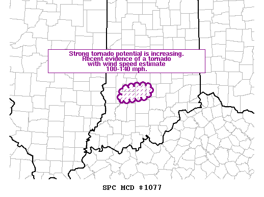
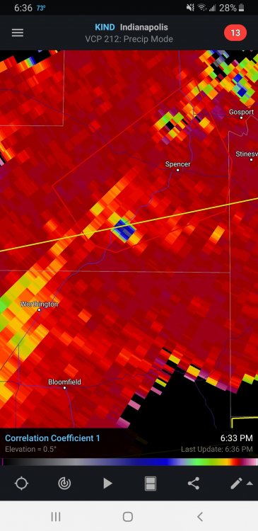
EF 0 confirmed in NW Darke County OH by ILN. -
2019 Short/Medium Range Severe Weather Thread
snowlover2 replied to snowlover2's topic in Lakes/Ohio Valley
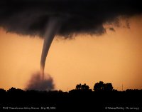
Tornado warnings popping up in E IN/W OH. -
2019 Short/Medium Range Severe Weather Thread
snowlover2 replied to snowlover2's topic in Lakes/Ohio Valley
Appears to be a severe threat middle of next week for most along and south of I-80. SPC has a day 5 and 6 slight risk outlined for those areas. -
2019 Short/Medium Range Severe Weather Thread
snowlover2 replied to snowlover2's topic in Lakes/Ohio Valley
Could be some severe tomorrow for southern parts of the sub. -
This thread is for discussion of weaker non thread worthy severe threat and medium range potential events. Speaking of which. SPC just recently added an enhanced area for large hail for SE MO and SW IL. Slight risk area surrounds that up to S IL.
-
You should look at the 0z GGEM.

