

LP08
-
Posts
3,709 -
Joined
-
Last visited
Content Type
Profiles
Blogs
Forums
American Weather
Media Demo
Store
Gallery
Everything posted by LP08
-
I’d weenie myself but if it’s there I’ll look at it!
-
Fine I’ll be the one to say it. Good looking end of the run on the NAM
-
Yes! And on mobile on pivotal “beta” there is a giant Ragu add at the bottom now I have to refresh every time lol
-
Baja sw still ejects but the northern stream doesn’t dig as far west and scoots east to beat down heights out front.
-
AiGFS with a noticeable bump south. Still decent but the heaviest are down at the VA/NC border and south
-
The AIgfs is like 3’ through the run with 3 storms with temps in the teens for every single one of them. Putting it here but that may be one of the weeniest runs I’ve ever seen
-
Icon through 108 is less suppressive over the ne and the Baja closes low is further east than 6z and 0z
-
I followed the storm up in New England this past weekend. Both AIs were extremely persistent with bringing snow into southern New England when most guidance, including the euro were pretty far out to sea. Good study for our area. hell they even named their storm thread “rise of the machines” lol
-
Could only see surface temps. Just glad it’s a big precip maker still
-
As long as temps are good, ai looks like another winner
-
Do you know their resolution compared to the OPs? Everything looks “smoother” and since this is such a delicate balance of wave interactions, I do wonder if that’s why they are west comparatively.
-
Both AI models (euro and gfs) are wester than everything right now. A good test to see how those perform.
-
I’m just hoping to get some real qpf with this upcoming pattern. I hope this period doesn’t result to the same 75 mile wide “win zone” of 0.2” of precip fluctuating each run we have been dealing with the past few years.
-
So the NAM has snow for Sunday FYI.
-
Ai gfs insists for Sunday as well
-
Icon is east of east lol
-
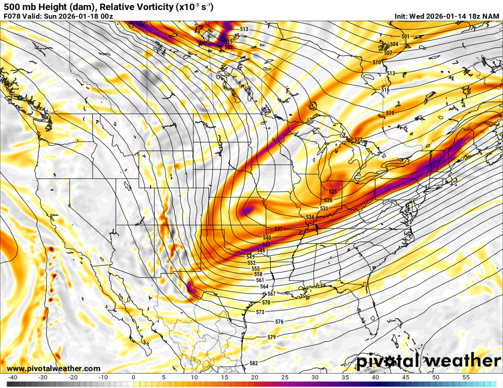
The base of the trough is so much further west than all other guidance at 78. Toggle compare the runs. https://beta.pivotalweather.com/models/nam/500hv/conus?run=2026011512&forecastHour=75
-
The base is a bit more west but don't love out front of it with the compression of heights through 57.
-
I'm older too and even I KNOW he shouldn't be using that lol
-
Just wide right but a nice move west.
-
Icon gets snow to dc-east.
-
Looks like the “kicker/wave spacing” piece in Canada shifted north some giving the southern piece more room to tilt.
-
Anybody got the H5 euro maps? Curious to see what trended in our favor and what to look for. Pivotal is down for me.
-
definitely wasn’t saying one or the other was correct. Someone said it looked like the gfs so I had to look. Yes the ridge out west may be a smidge taller, but in the grand scheme of things, the larger scale trough was progressive and not what we would need.
-
Unfortunately I agree, pretty damn close honestly. Not close to the GFS.
.thumb.png.e547e5a0ee128fb6a68ad7605ff35feb.png)


.png.bb615939353fcf2304554f7e0b3a4527.png)

