weatherwiz
-
Posts
76,585 -
Joined
-
Last visited
Content Type
Profiles
Blogs
Forums
American Weather
Media Demo
Store
Gallery
Everything posted by weatherwiz
-

July 2025 Obs/Disco ... possible historic month for heat
weatherwiz replied to Typhoon Tip's topic in New England
Everyone is doing cookouts today. Having the 4th on a Friday was perfect. Friday is a rest day from work, Saturday is fun day, and Sunday is a relax day. -
July 2025 Obs/Disco ... possible historic month for heat
weatherwiz replied to Typhoon Tip's topic in New England
Beautiful day for a cookout
-
July 2025 Obs/Disco ... possible historic month for heat
weatherwiz replied to Typhoon Tip's topic in New England
I love that Big Y. Even when its busy, its manageable to get around the store and I don't think I've ever had to wait more than 2-3 minutes to get a self checkout register. -
July 2025 Obs/Disco ... possible historic month for heat
weatherwiz replied to Typhoon Tip's topic in New England
Good call, you sniffed this out several days ago -
July 2025 Obs/Disco ... possible historic month for heat
weatherwiz replied to Typhoon Tip's topic in New England
That was at Big Y in Wilbraham, MA! Sorry for late response -
July 2025 Obs/Disco ... possible historic month for heat
weatherwiz replied to Typhoon Tip's topic in New England
WOAH!!
-
July 2025 Obs/Disco ... possible historic month for heat
weatherwiz replied to Typhoon Tip's topic in New England
AWT -
July 2025 Obs/Disco ... possible historic month for heat
weatherwiz replied to Typhoon Tip's topic in New England
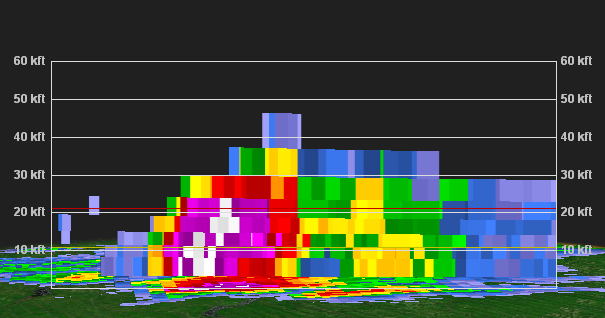
Indeed! Wished there was more lightning but good winds and instances of hail over the course of a 5-7 minute span -
July 2025 Obs/Disco ... possible historic month for heat
weatherwiz replied to Typhoon Tip's topic in New England
-
July 2025 Obs/Disco ... possible historic month for heat
weatherwiz replied to Typhoon Tip's topic in New England
43 knots…was going to say 45-50 mph gusts too -
July 2025 Obs/Disco ... possible historic month for heat
weatherwiz replied to Typhoon Tip's topic in New England
HAIL!!!! -
July 2025 Obs/Disco ... possible historic month for heat
weatherwiz replied to Typhoon Tip's topic in New England
Finally lightning -
July 2025 Obs/Disco ... possible historic month for heat
weatherwiz replied to Typhoon Tip's topic in New England
So far only see a rain shaft. Haven’t seen any lightning. That’s not encouraging -
July 2025 Obs/Disco ... possible historic month for heat
weatherwiz replied to Typhoon Tip's topic in New England
-
July 2025 Obs/Disco ... possible historic month for heat
weatherwiz replied to Typhoon Tip's topic in New England
I get so upset the rest of the day when I do. You have to go at like 7 PM. I’m just going to go to big y after. but might have a shelf developing with that leading cell!! -
July 2025 Obs/Disco ... possible historic month for heat
weatherwiz replied to Typhoon Tip's topic in New England
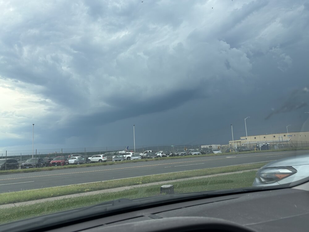
SCREW COSTCO. Place was a disaster. Was going to just sit in the parking lot and wait for storms but cell service was awful so I elected to go to BDL…getting out of the parking lot was an absolutely miserable experience and getting to the highway sucked. But I made it to BDL! -
July 2025 Obs/Disco ... possible historic month for heat
weatherwiz replied to Typhoon Tip's topic in New England
The HRRR is making my life very difficult. I would love for good storms to end up through BDL but I have to go from Branford to Costco in Enfield then to Springfield and then figure out from there. But with how slow people walk in Costco and the 8 million people there I'll be in there for 8 hours. -
July 2025 Obs/Disco ... possible historic month for heat
weatherwiz replied to Typhoon Tip's topic in New England
The HRRR is beyond lost -
July 2025 Obs/Disco ... possible historic month for heat
weatherwiz replied to Typhoon Tip's topic in New England
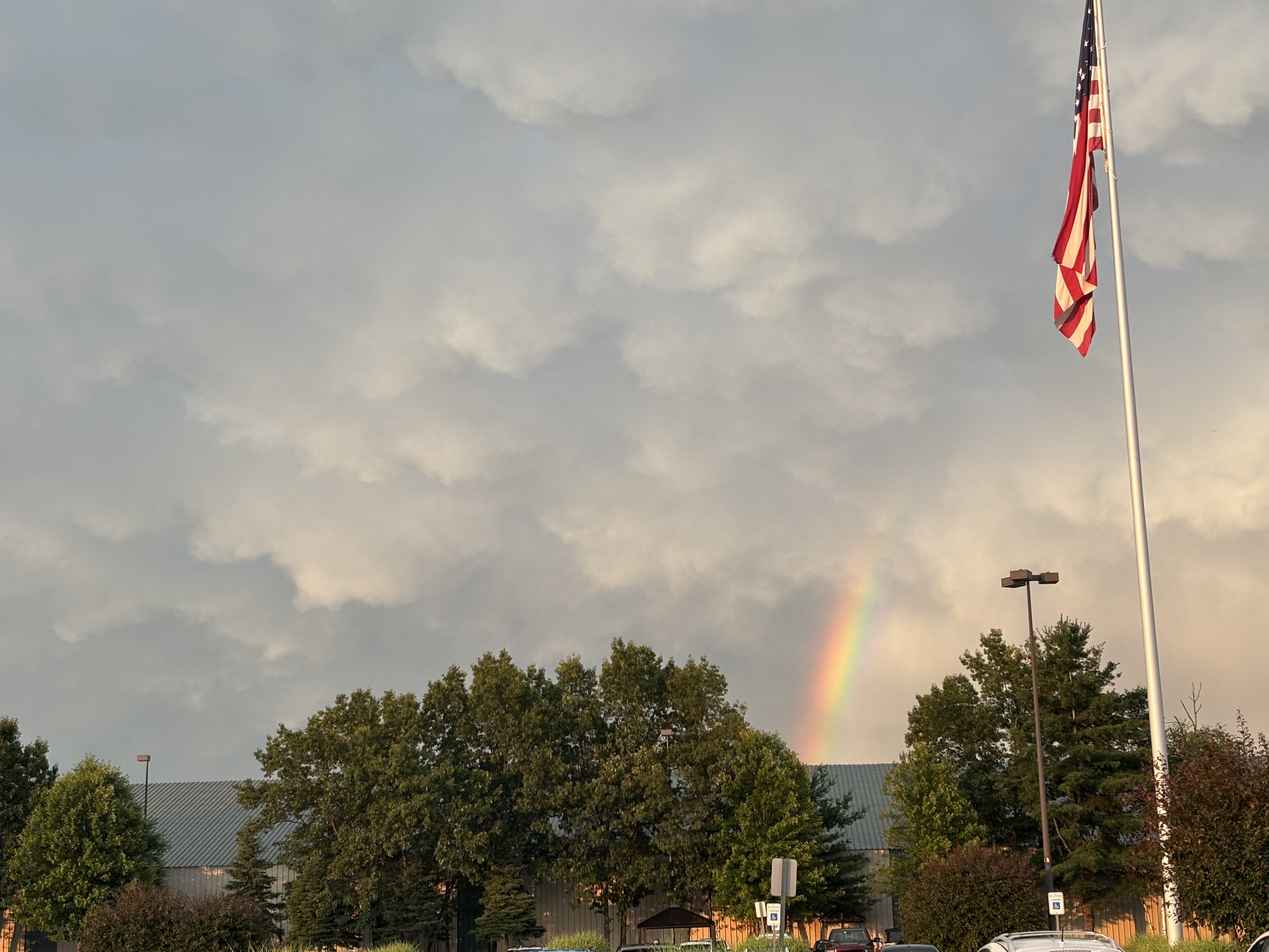
wow that is intensifying quickly. that's a nice inflow notch -
July 2025 Obs/Disco ... possible historic month for heat
weatherwiz replied to Typhoon Tip's topic in New England
Tornado warning near Ithaca -
July 2025 Obs/Disco ... possible historic month for heat
weatherwiz replied to Typhoon Tip's topic in New England
We might be in business for later...impressive CU field blowing up over SW NY -
July 2025 Obs/Disco ... possible historic month for heat
weatherwiz replied to Typhoon Tip's topic in New England
The dew trends have been interesting. It still seems though that the HRRR is a bit off with the dews but it does increases dews later this afternoon/early evening (as you'd expect) and that's when it kind of generates more precip. Also wondering if maybe we dry things out a bit too much in the mlvls. It's going to be interesting to see how things unfold later this afternoon. -
July 2025 Obs/Disco ... possible historic month for heat
weatherwiz replied to Typhoon Tip's topic in New England
We may actually get screwed down here. Dews are dropping behind that feature moving through...unless they rebound -
July 2025 Obs/Disco ... possible historic month for heat
weatherwiz replied to Typhoon Tip's topic in New England
Looks like we should be solidly above average, even behind any FROPAs...the only thing we'll noticeably have is a brief period of lower dews. People could call this cheap or whatever because it could be alot of 90/91's but some of the typical torch spots will have a good shot to rack up some 90's over the next few weeks. A quick glimpse of the pattern too should yield hope for MCS potential but we probably get screwed and everything goes from northern Plains, upper-Midwest, Ohio Valley -
July 2025 Obs/Disco ... possible historic month for heat
weatherwiz replied to Typhoon Tip's topic in New England
what a supercell in far northwestern Maine