

weatherwiz
-
Posts
71,152 -
Joined
-
Last visited
Content Type
Profiles
Blogs
Forums
American Weather
Media Demo
Store
Gallery
Posts posted by weatherwiz
-
-
It’s cold
-
90!!!!!! Let’s go.
May tack on two more Wednesday and Thursday. That would get us within 1.
-
 2
2
-
-
4 minutes ago, dendrite said:
There aren't many things meteorologically more riveting than BDL hitting 90F in the summer...probably only dew talk and my soil temperature.
maybe we'll get a labor day 98 to plow through the region and make up for the boring summer
-
Just now, dendrite said:
Enjoy the cool down next week.
First half of the week will be a refresher but boom. Maybe we can get some dying convection on Monday.
-
 1
1
-
-
12z euro too wanting to throw some heat our way. If BDL falls one shy of the record I demand every day that hit 89 be reanalyzed...maybe someone forgot to round.
-
2
-
-
3 minutes ago, dendrite said:
Flow off the water right now...near 70°
Interior or offshore flow...85-90°+
despite the boring wx there temperature gradients are certainly intriguing and I'm sure quite challenging at times. the entire west may engulf in flames by next week
-
One problem is we will continue to struggle with pushing any meaningful cold fronts through here. Given what is being advertised on the Euro and GFS we would see a plume of anomalously warm 850 temperatures push well into Canada and southeast Canada and then right into our region...almost similar to I think what happened in June...(just w/o the cut-off to the south). There offers potential to get a solid NW flow down the road...sure sun angle is decreasing but a downslope flow with dry ground at favorable areas are going to torch.
-
1
-
1
-
-
6 minutes ago, snowman21 said:
Keep in mind we're losing 3 minutes of daylight per day, means are declining, sun angle is rapidly declining. It's not just about the pattern. There's a reason climo is climo, and even the mighty BDL 'mac has trouble getting to 90 after about the 23rd of August. If Ryan's 10-day is right, which takes us to the last week of August, yesterday and today are critical for BDL breaking the record. If you're expecting a late summer like '83 or '73 then yeah I guess it doesn't matter and we'll blow past the record, but I wouldn't bet on it.
I disagree with that to an extent. In fact, you could argue pattern becomes even more critical. Late June and July..we bang bang out 90 "relatively easy"...you don't need that crazy anomalous pattern or airmass...earlier than that and later than that it likely need it more.
The look on the pattern (at least through the end of the month offers a much higher potential for heat against average or below-average. With the strength of the western and WAR ridge's there is plenty of room and window to pinch heat into our region. We have to solely rely on troughs to dig in and for some actual cold fronts to move through. Maybe perhaps some weaknesses develop within the WAR but as long as it stays that developed it's going to take numerous trough ejections and fronts to really weaken in.
-
guhhhhh BDL got to 89...let's see if they can tack on that extra degree.
-
1
-
-
5 minutes ago, ineedsnow said:
Not for here but every models develops a huge storm in the North Atlantic.. That could shake the pattern a bit..
You know...may need one of those suckers (either in ATL or PAC) to do that.
-
BDL up to 87!
-
you've been warned
-
2 minutes ago, Damage In Tolland said:
35. 3 to tie , 4 to break. Should get to 40 based on pattern upcoming
I think signals are increasing we tack on at least another two days towards the end of next week. signal for a trough is becoming less...looks more like a de-amplifying trough with a nice westerly mid-level flow.
-
 1
1
-
-
2 minutes ago, Damage In Tolland said:
Locked today
I think so. Today would be #36?
-
BDL jumped to 84 last hour...thought perhaps they could do 85 or even 86. Assuming another 4F increase next hour that gets to 88 with another few hours of peak heating. Think 90 is well within reach
-
Really starting to crank in the EPAC
-
BDL was 80 last ob but looks like they should get into some strong heating soon so I would expect a decent jump in the next hour.
-
1 minute ago, Cold Miser said:
Yeah. That was it, 2018. It was a good run, but then all of a sudden the wall was hit, and it was only mid 80's as highs for the rest of the season. I think that may happen again this yea, with a few high 80's thrown in there.
I might even have to make a bet with Kevin that we DON'T break the record.I think we do have a shot to break the record. It's going to come down to how well established any troughing to our northwest becomes. There is still a very strong signal moving forward for the western ridge and western-Atlantic ridge to significantly dominate the pattern regime across the country. However, there are also signals for more potent troughs/cold fronts to show their face in our region.
I just wouldn't rule it out yet b/c there are signals for some heat to sneak into our area towards the end of next week. With how dry it is all we really need is a favorable wind direction and a pinch of the heat ridge to break off and move overhead.
-
1 minute ago, snowman21 said:
90-degree days at BDL:
1983 38
2002 35
2020 34
2010 34
1965 34
2018 32
1966 32
2016 31
1991 31
1988 30
1973 30Thanks. I wanted to say it was 2018. If I remember correctly, we got those last few days earlier in August? I also think June had more 90F days too...I know this year I think June had like one or two? July set a record I think with 20.
-
1
-
-
56 minutes ago, Cold Miser said:
Didn't BDL get close to the record last year too?
I think a few years ago BDL made a run into the 30's...I want to we may even be slightly ahead of that year too. But BDL will definitely have to hit 90 today to probably have a chance. Of course it's 7-days out but there is a window to sneak some heat in here towards the end of next week and next weekend. Could be a big difference too between NNE and SNE in terms of temps.
-
1
-
-
If shear didn't look overly strong the GoM could be of interest moving into next weekend.
-
9 hours ago, CoastalWx said:
Meh still dry air around too. Don’t see RI happening that some saw.
Josephine was never a threat to the eastern U.S. Outside of Puerto Rico or the Virgin Islands just mostly fish fun.
-
5 minutes ago, HoarfrostHubb said:
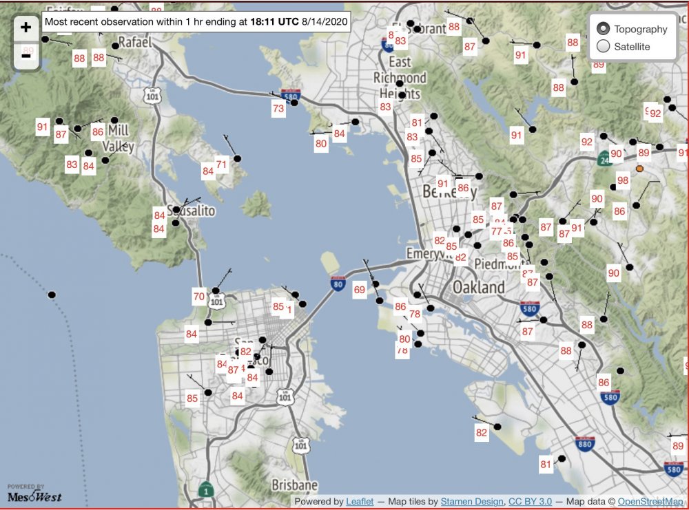
Highest elevation in Oakland is 1760’ asl. So big el changes possible. Maybe that also plays a role?
Certainly could be a factor with northeasterly winds.
-
3 minutes ago, dendrite said:
There’s always a big difference down there depending on wind direction. Inland torches and the shore gets Pacific puke.
Oakland is one of those locations where one side of town can bake while the other side of town is like 10-15F cooler? I guess any time there would be a wind component off the bay or ocean you can forget a torch. I'm guessing a NW wind would mean less marine taint for them?
I remember a while back trying to use mixing heights/bufkit to see if that provided better accuracy with temp forecasting but I remember the GFS always going crazy mix happy there and would constantly result in temperatures well into the 80's. I also wouldn't think OAK is a location that mixes very well so I've wanted to look more into if using 925mb temps could give a solid idea (to gauge the airmass in place)? Also see NAM MOS has 96 today while GFS 86 (although 3-HR high on NAM is 91). They even pulled off the 90 yesterday with partly sunny skies.

August 2020 Discussion
in New England
Posted
Just read about it on wiki...incredibly interesting!