-
Posts
80,247 -
Joined
-
Last visited
Content Type
Profiles
Blogs
Forums
American Weather
Media Demo
Store
Gallery
Everything posted by weatherwiz
-

It was a Flop... February 2024 Disco. Thread
weatherwiz replied to Prismshine Productions's topic in New England
I mean even the NAM is well mixed on bufkit and showing gusts over 50 mph. NAM actually looked a bit more mixed than the GFS. That's a pretty steep lapse rate in the lowest few km -

It was a Flop... February 2024 Disco. Thread
weatherwiz replied to Prismshine Productions's topic in New England
Im shocked no wind advisory for N CT -

It was a Flop... February 2024 Disco. Thread
weatherwiz replied to Prismshine Productions's topic in New England
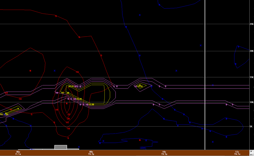
This is the 6z NAM bufkit for BDL. Brief, but would certainly rip. that could drop a quick 1-1.5'' of snow -

It was a Flop... February 2024 Disco. Thread
weatherwiz replied to Prismshine Productions's topic in New England
doesn't look like it, though we may see some snow showers late as we have the trough rotating through. -

It was a Flop... February 2024 Disco. Thread
weatherwiz replied to Prismshine Productions's topic in New England
3km NAM has a heck of a LES streamer reaching all the way to the Berks late overnight -

It was a Flop... February 2024 Disco. Thread
weatherwiz replied to Prismshine Productions's topic in New England
That is a pretty impressive anafront passing to our southwest tomorrow. -

It was a Flop... February 2024 Disco. Thread
weatherwiz replied to Prismshine Productions's topic in New England
Unfortunately, it is very difficult in our society to have great debate without discussion turning personal. Everyone thinks their view is correct and the opposing view is incorrect. Some of the posts from several pages back discussing MJO/warm pool, etc were quite interesting. There should be a spinoff thread somewhere else to continue that discussion. -

It was a Flop... February 2024 Disco. Thread
weatherwiz replied to Prismshine Productions's topic in New England
Yup...understandable, and i get it regarding the politics of it. But IMO, if there is a great discussion going on with a back-and-forth of data, data interpretation, hypothesis/thesis, and arguments then it should be totally fine. If someone or people are going to throw a tantrum because what they're reading goes against their beliefs and cry for the discussion to stop then that is ridiculous. There are some on here who probably are involved in the work force or research where this topic is virtually their entire career and they should be able to elicit discussion. If people have a problem with discussing science...in any thread but have no problem tossing around sexual jokes and making sexual references I think we can see where the problem lies. -

It was a Flop... February 2024 Disco. Thread
weatherwiz replied to Prismshine Productions's topic in New England
Why do some get so bent out of shape when there is discussion which incorporates climate change/global warming? Read through some of the last 5-7 pages and there is some excellent discussion/debate. I get there is the whole climate change form and whatever but there is nothing wrong with great debate and discussion and much of what has been posted has been very informative. Maybe there is a place for it but its much better than the constant sexual references and posts which have zero value -

It was a Flop... February 2024 Disco. Thread
weatherwiz replied to Prismshine Productions's topic in New England
I'm pretty sure January was solidly below-average for Anchorage. They had some prolonged stretches of extreme cold. -

It was a Flop... February 2024 Disco. Thread
weatherwiz replied to Prismshine Productions's topic in New England
could be wrong...thought I had come across something recently that it was one of their coldest to. -
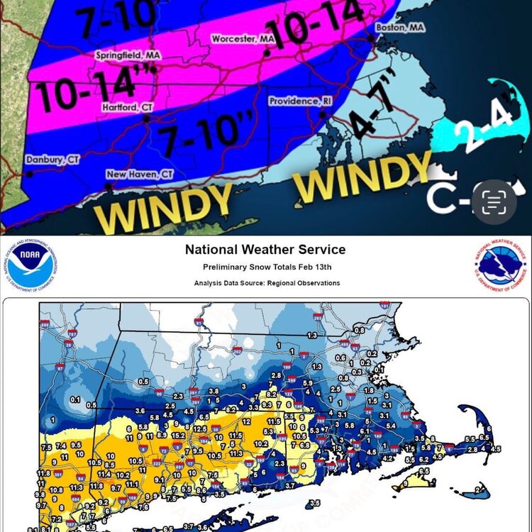
Certainly not happy with this forecast at all. Maybe it looks “fine” for Connecticut but an absolute disaster along the Mass Pike area and I essentially pulled the plug and called bust for Connecticut Monday evening. now ultimately one could say all I had to do was just shift this down some miles and tighten the gradient. If I had more time/energy I would have made an updated map but l would have not made those changes. I would have went significantly less for Connecticut and maybe do 4-7” southern and 2-4” so it would have been much worse if I did something so this map makes the forecast better than it would have been.
-

It was a Flop... February 2024 Disco. Thread
weatherwiz replied to Prismshine Productions's topic in New England
What a winter for Anchorage. One of their coldest/snowiest on record then they roll in with a daily record high yesterday. They must be jumping for joy...unless they like the cold. -

It was a Flop... February 2024 Disco. Thread
weatherwiz replied to Prismshine Productions's topic in New England
There is a narrow, but large swath of WWA's and even some winter storm warning's along the expected path of this clipper so we'll certainly want to see how that ends up performing. Something else to watch is whether the core of the system passes over the Great Lakes as sometimes that can provide the system with additional moisture. -

It was a Flop... February 2024 Disco. Thread
weatherwiz replied to Prismshine Productions's topic in New England
Yeah you can see the dry slot on guidance punch right into SNE after that quick WAA burst potential. I think there is room to dig that vort a bit more given the jet streak hasn't yet rounded the base of the trough as it is crossing NNE but that flow is pretty fast and the digging may happen too late for us. I'd watch for some advisory snows in southwest Maine into parts of New Hampshire. There also looks to be a bit of an inverted trough signal. -

It was a Flop... February 2024 Disco. Thread
weatherwiz replied to Prismshine Productions's topic in New England
I think the QPF is being underdone. Dynamics are pretty impressive and RH fields look good (though I didn't look at any soundings so maybe they are showing some dry layers). But that is a potent H5 jet streak moving in, looks like the nose of it coincides with the best lift/forcing too. I would anticipate precip could break out across much of the region. -

It was a Flop... February 2024 Disco. Thread
weatherwiz replied to Prismshine Productions's topic in New England
Don't even respond to them. The value and knowledge you bring is immense. It's a refresher to be able to divulge deep into the meteorology and not just scroll past 1000 snow maps 300 hours out. When we're discussing patterns and potential nobody is guaranteeing anything will happen, if people are taking it that way that is their issue. It's meteorology 101 that when you're looking medium range and beyond to gauge the pattern and use knowledge of how those patterns have performed historically. But they know this...they just like to troll. -

It was a Flop... February 2024 Disco. Thread
weatherwiz replied to Prismshine Productions's topic in New England
I would not be surprised to see mesos continue to beef up a bit more throughout the day. I haven't look in tremendous detail yet to see if this is something which will be a larger, more uniform precipitation shield or something that is more along the line of scattered-to-numerous squalls. I think the HRRR may have a solid idea of a more uniform precip shield further north, closer to the vort with squalls from PA through SNE. -

It was a Flop... February 2024 Disco. Thread
weatherwiz replied to Prismshine Productions's topic in New England
Yeah I stepped outside like 30 minutes ago to grab a package...it certainly felt like winter. While I don't have much of a snow pack here I am loving today. Despite the cold/wind the sun makes it much better. -

It was a Flop... February 2024 Disco. Thread
weatherwiz replied to Prismshine Productions's topic in New England
Tomorrow night could certainly overperform I think. NAM has the s/w amplifying as it moves across the region. Some pretty steep lapse rates involved too. Could be some hefty snow squalls. Maybe even some thunder/lightning across Pennsylvania with squalls which could propagate across southern New England. I could see some spots picking up 1-2''. -

It was a Flop... February 2024 Disco. Thread
weatherwiz replied to Prismshine Productions's topic in New England
I just uninstalled my bedroom A/C the other day -
Working on a little (well shouldn't say little it will be a bit long) blog post doing a bit of a recap. Won't finish tonight because the Bruins are on in 30 min. Probably won't be able to finish tomorrow because doing Valentine's Day dinner after work. Maybe I can finish Thursday after work before the Bruins game.


